|
|
Find A Cemetery (Maps, Photos, &
Transcriptions)
Brunswick County, North Carolina
©2005-2011 |
Known
Brunswick County Cemeteries with Maps
Listed below are almost 400 cemeteries and burial
sites in Brunswick County. I owe much gratitude to the
Brunswick County GIS
department for a lot of this information. The GIS
department undertook the tremendously important task
of documenting and mapping every known burial site in
the county.This listing below reflects all currently
known cemeteries in Brunswick County.
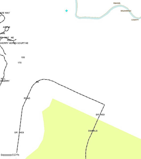
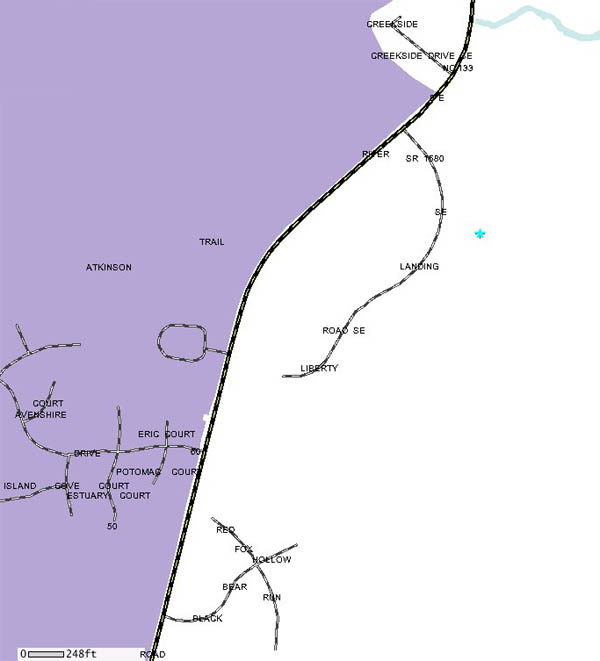
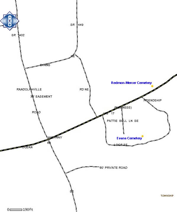
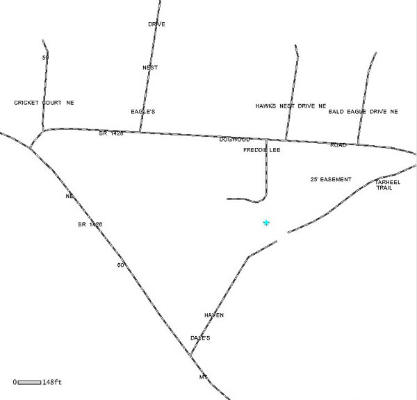
Please keep in mind that the street maps linked show
approximate locations of cemeteries, and are not
always exact. Street maps, topographic maps, and GIS
maps are all offered to help one find a cemetery in
which they are interested, and these should show a
reasonable search area, if not always an exact
location.
Note about topographic maps: cemeteries are usually
located in the middle of the maps, and are marked as
"cem," or sometimes they are marked with a cross. Some
topographic maps show more than one cemetery.
Please submit
your corrections as well as your cemetery
transcriptions and pictures for the site. All cemetery
information is valuable and is always appreciated.
|
NEW!!
For added ease in navigation, each section is now
expandable and collapsible. Click on the letters below
to open and close each section. Cemeteries are arranged
alphabetically.
|
Allan Cemetery, Winnabow
River Road
Note: Tax Map #129
(4 graves)
street
map
Brunswick County GIS
map |
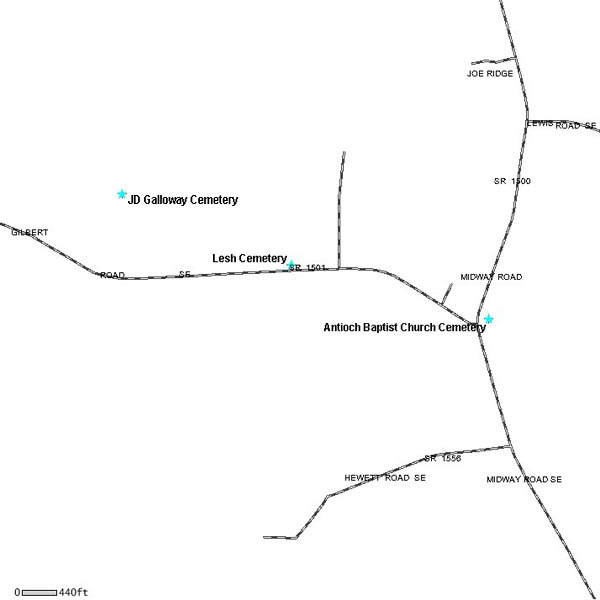
Antioch Baptist
Church Cemetery, Bolivia
1700 Midway Road
street
map
topographic
map |
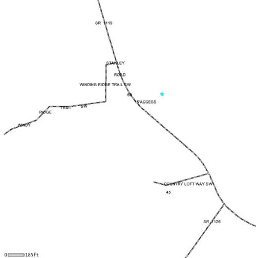
Bachelor Swamp Cemetery, Supply
Stanley Road
(Timeline: 1861-1903; 4 marked graves; many
unmarked; within a fenced goat pen)
street
map
Brunswick County GIS
map |
Ballard Cemetery,
Leland
Blue Banks Loop Road
Note: Tax Map #6
online transcription
street
map
Brunswick County GIS
map |
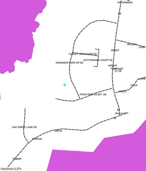
Beaver Dam Cemetery at Arbor Creek,
Southport
Cinnamon Fern Drive, off of Creek Drive
 online
transcription online
transcription
street
map
Brunswick County GIS
map |
Beck Cemetery,
Calabash
Hwy 17
online transcription
street
map
topographic
map |
Bellamy Cemetery, Supply
W Tanglewood Drive
online
transcription
street
map
topographic
map |
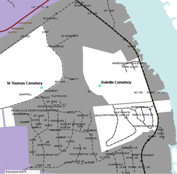
Belville
Cemetery, Winnabow
River Road
newspaper
article
street
map
Brunswick County GIS
map |
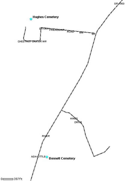
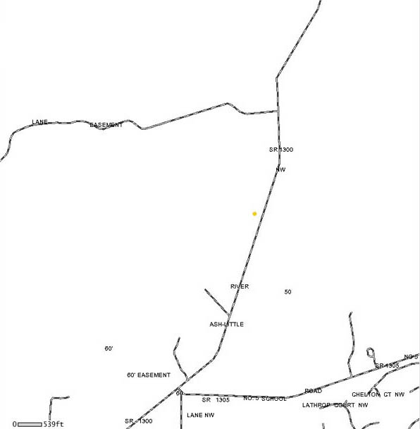
Bennettown Cemetery, Ash
2206 Ash-Little River Road
online
transcription
street
map
topographic
map
Brunswick County GIS
map |
Bennett Cemetery,
Sunset Beach
AKA Frink Cemetery
Hwy 179/Old Georgetown Road
online transcription
street
map |
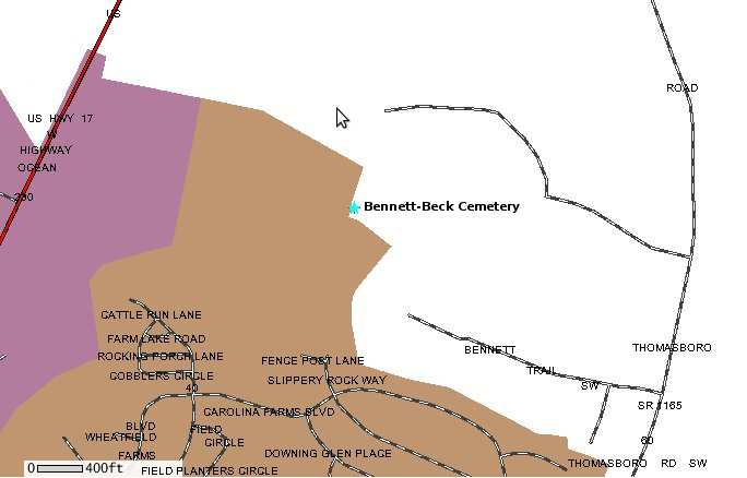
Bennett-Beck Cemetery, Thomasboro
Bennett Trail
online
transcription
street
map
Brunswick County
GIS map |
Samuel Bennett Jr
Family Plot, Shallotte
963 Village Point Road
online transcription
street
map
Brunswick County GIS
map |
Benton Cemetery, Leland
(AKA Watson-Benton Cemetery)
Colon Mintz Road
online
transcription
street
map
topographic
map |
Kennie Benton
Cemetery, Leland
Miller Trail
street
map
Brunswick County GIS
map |
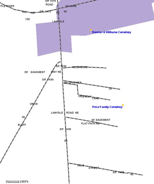
Benton - Williams Cemetery, Leland
1634 Lanvale Road
street
map
Brunswick County GIS map |
Bethel Baptist
Church Cemetery, Southport
Bethel Road
online transcription
street
map
topographic
map |
Bethel Methodist Church Cemetery, Leland
Goose Neck Road
street
map
topographic
map
Brunswick County GIS
map |
Bethel Primitive
Church Cemetery, Calabash
Hickman Road
online
transcription
street
map
topographic
map |
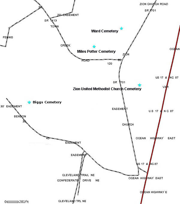
Biggs Cemetery, Leland
Benson Road
Note: Tax Map #70
online
transcription
street
map
Brunswick County GIS
map |
Bingham Field
Cemetery, Shallotte
554 Gladstone Circle
online transcription
street
map
topographic
map |
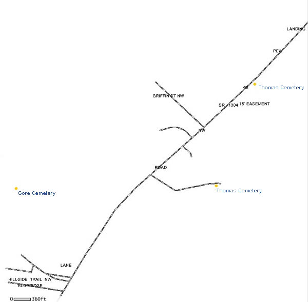
.Bland Cemetery, Ash
AKA Gore Cemetery
No 5 School Road
street
map
Brunswick County GIS
map |
Blanton Cemetery,
Calabash
(AKA Hardee Cemetery)
Robert Blanton Road
online transcription
street
map
topographic
map |
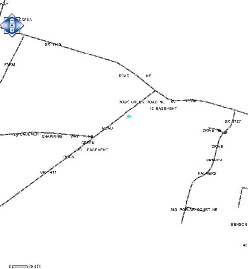
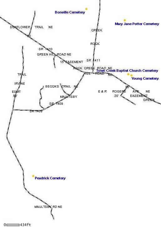
Bonville Cemetery, Leland
Rock Creek Road
Note: Tax Map #69
(2 marked graves; 3 unmarked graves)
street
map
Brunswick County GIS map |
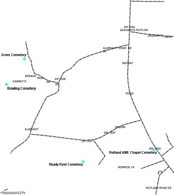
Bowling Cemetery,
Bolivia
Carney's Branch Trail
online transcription
street
map
Brunswick County GIS
map |
Brown Cemetery, Bolivia
Mercers Mill Trail off of Hwy 211
Note: Tax Map #186
online
transcription (partial)
street
map
Brunswick County GIS
map |
Brown Cemetery,
Leland
Saw Mill Road
(Timeline: 1972-1973; 2 graves)
street
map
Brunswick County GIS map |
Brown Cemetery, Winnabow
River Road
street
map
Brunswick County GIS map |
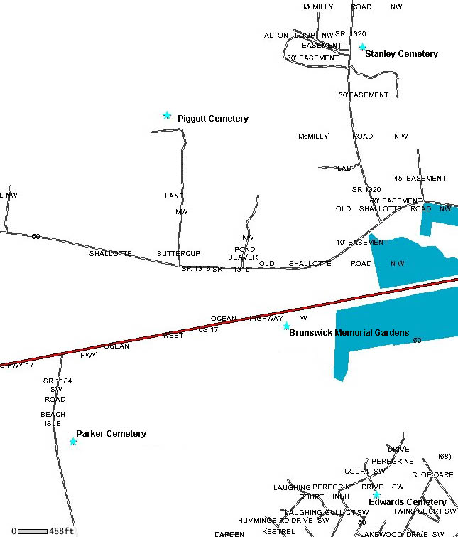
Brunswick
Memorial Gardens, Shallotte
Hwy 17
street
map
topographic
map
Brunswick County GIS
map |
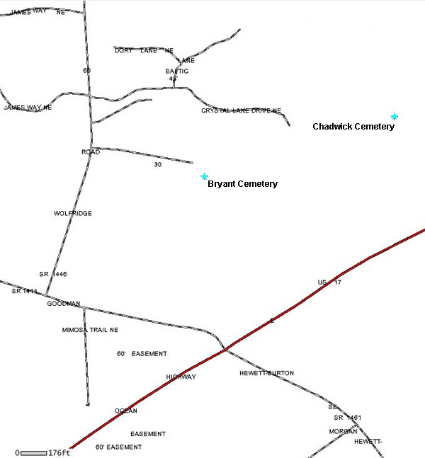
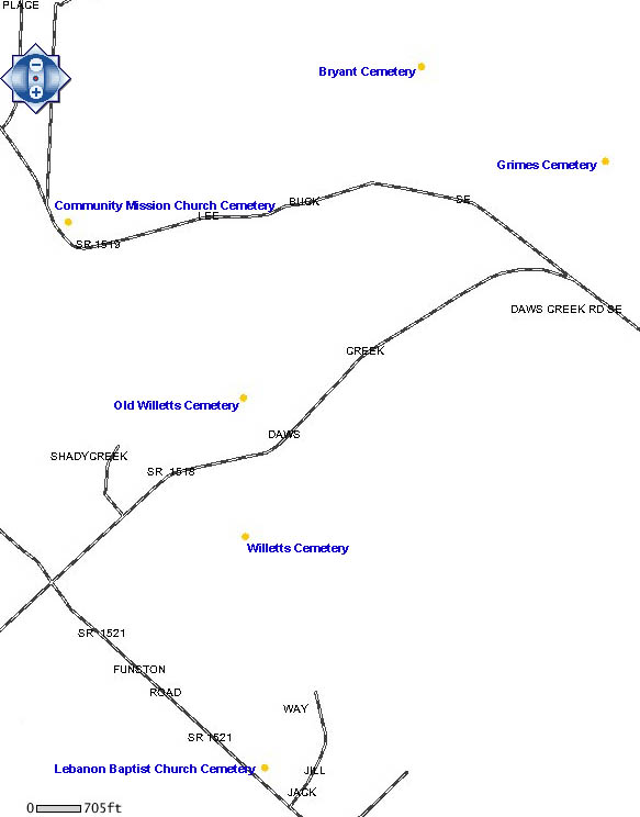
.Bryant Cemetery, Leland
Laurel Way
street
map
Brunswick County
GIS map |
Samuel Bryant
Cemetery, Supply
Chimney Way
Note: Tax Map #200
street
map
Brunswick County GIS
map |
Bryant Cemetery, Winnabow
Lee Buck Road
Note: Tax Map #85
online
transcription
street
map
Brunswick County GIS
map |
Burton Cemetery,
Leland
Burton Trail
online transcription
street
map
Brunswick County GIS map |
|
Caison Cemetery, Shallotte
Holden Beach Road
online
transcription
street
map
Brunswick County GIS map |
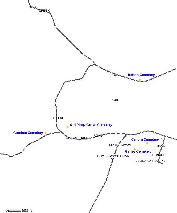
Callum Cemetery,
Leland
Green Hill Road
Note: Tax Map #68
online transcription
street
map
Brunswick County GIS map |
Camp Branch Baptist Church Cemetery,
Shallotte
Camp Branch Road
online
transcription
street
map
topographic
map
Brunswick County GIS
map |
Cape Fear
Memorial Park, Southport
Southport-Supply Road
street
map
topographic
map |
.Carlisle Cemetery, Ash
Ash-Little River Road
street
map
Brunswick County GIS
map |
Carroll Cemetery,
Leland
Green Loop Road
online transcription
street
map
Brunswick County GIS
map |
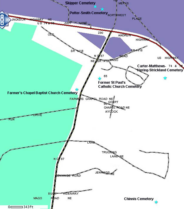
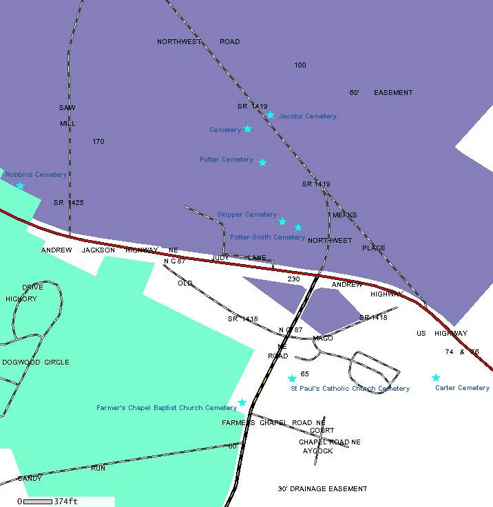
Carter Cemetery, Maco
AKA Matthews-Hering-Strickland Cemetery
Bacon's Way
online transcription
street
map
Brunswick County GIS map |
Cedar Hill
Cemetery, Leland
Cedar Hill Road
online transcription
street map
topographic
map
Brunswick County GIS
map |
Chadwick Cemetery, Leland
AKA Gore Cemetery
Hwy 17
online transcription
street
map
Brunswick County GIS
map |
.Chadwick
Cemetery, Shallotte
Hidden Shores Drive
street map
Brunswick County GIS
map |
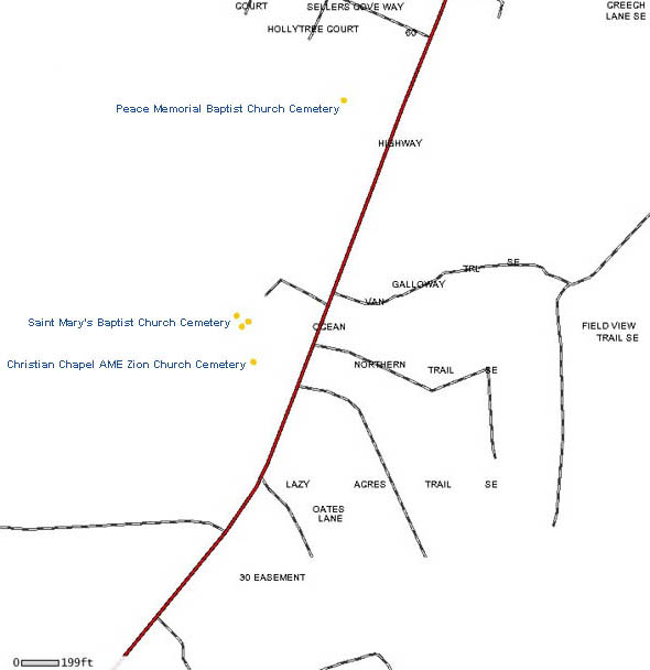
Christian Chapel AME Zion Cemetery,
Winnabow
5701 Ocean Highway East
street
map
Brunswick County GIS map
|
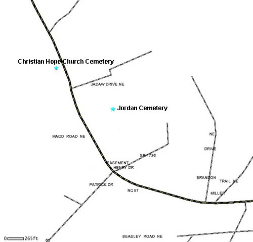
Christian Hope
Church Cemetery, Leland
2347 Maco Road NE
street
map
topographic
map
Brunswick County
GIS map |
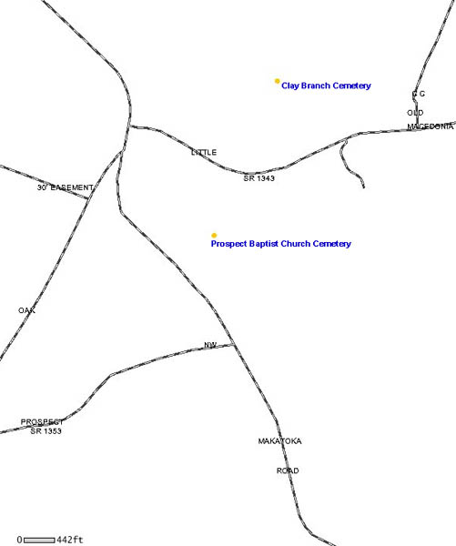
Claybranch Cemetery, Supply
Little Macedonia Road
Note: Tax Map #136
street
map
Brunswick County GIS
map |
Clemmons
Cemetery, Supply
Lawnie Dale Circle
online transcription
street
map |
Clemmons-Parker Cemetery, Supply
Mt Pisgah Road
(Timeline: 1955-1994)
street
map
Brunswick County GIS
map |
Coleman Cemetery,
Waccamaw
Hwy 130/Whiteville Road
street
map
topographic
map
Brunswick County GIS
map |
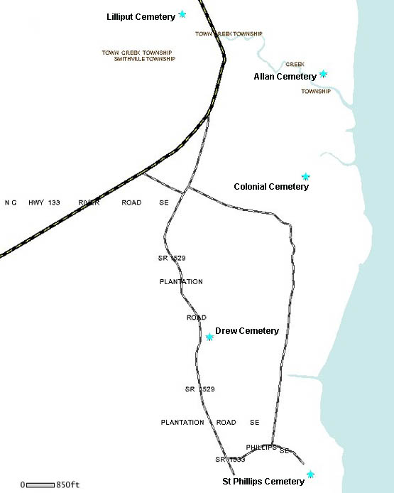
Colonial Cemetery, Winnabow
Orton Road
Note: Tax Map #144
street
map
topographic
map
Brunswick County GIS
map |
Community Chapel
Cemetery, Leland
Malmo Loop Road
online transcription
street
map
topographic
map
Brunswick County GIS
map |
|
|
Concord United
Methodist Church Cemetery, Supply
247 Southport Supply Road
online transcription
street
map
topographic
map |
Conway Cemetery, Leland
Blue Banks Loop Road
online transcription
street
map
Brunswick County GIS
map |
Coston Cemetery,
Leland
Blue Banks Loop Road
online transcription
street
map
Brunswick County GIS
map |
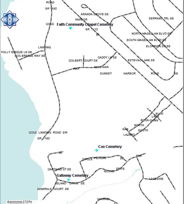
Cox Cemetery, Bolivia
Pelican Circle
street
map
Brunswick County GIS
map |
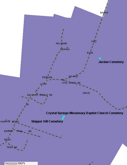
Crystal Spring
Church Cemetery, Leland
(AKA Skipper Hill Cemetery)
Blue Banks Loop Road
online
transcription
street
map
topographic
map
Brunswick County GIS map
|
Fred Cumbee Cemetery, Supply
Turnpike Road
(Timeline: 1998-Present)
online transcription
street
map
Brunswick County GIS
map |
Cumbee Cemetery,
Winnabow
Beetree Farm Trail
online transcription
street
map
topographic
map
Brunswick County GIS
map |
Cumbee-Hewett Cemetery, Winnabow
Beetree Farm Trail
(one wooden marker only)
photos
street
map
Brunswick County GIS map
|
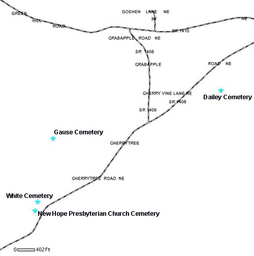
.Dailey Cemetery,
Winnabow
Cherrytree Road
(Timeline: 1958-1976)
street
map
Brunswick County GIS
map |
|
Damacus Road
Cemetery, Leland
|
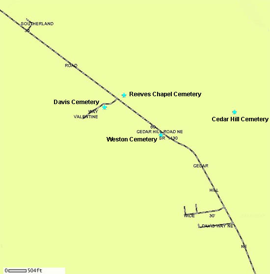
.Davis Cemetery,
Leland
AKA Moores Chapel Cemetery
River Road
(Timeline: 1800-Present; 12 graves)
street
map
Brunswick County GIS
map |
|
|
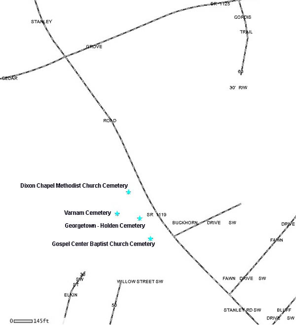
Dixon Chapel
Methodist Church Cemetery, Supply
190 Varnamtown Rd
street
map
topographic
map
Brunswick County GIS map
|
|
|
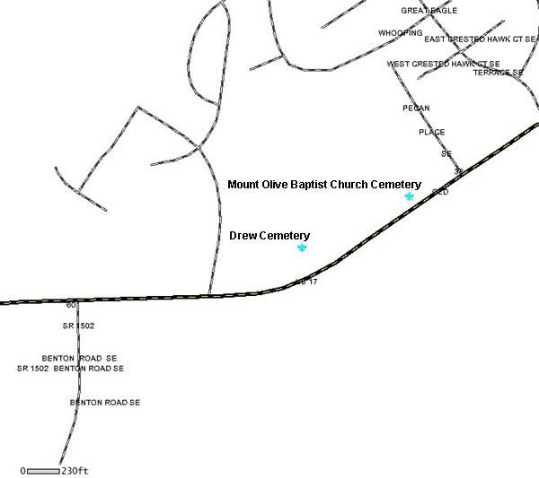
Drew Cemetery,
Winnabow
Plantation Road
street
map
topographic
map
Brunswick County
GIS map |
|
Edwards Cemetery, Ash
Aligator Road and Cox Road
Note: Tax Map #103
(Timeline: 1970; 3 graves)
street
map |
Edwards Cemetery,
Bolivia
Galloway Road
Note: Tax Map #123
(2 graves)
street
map
Brunswick County GIS map |
Edwards Cemetery, Shallotte
Phoebe Court
online transcription
street
map
Brunswick County GIS
map |
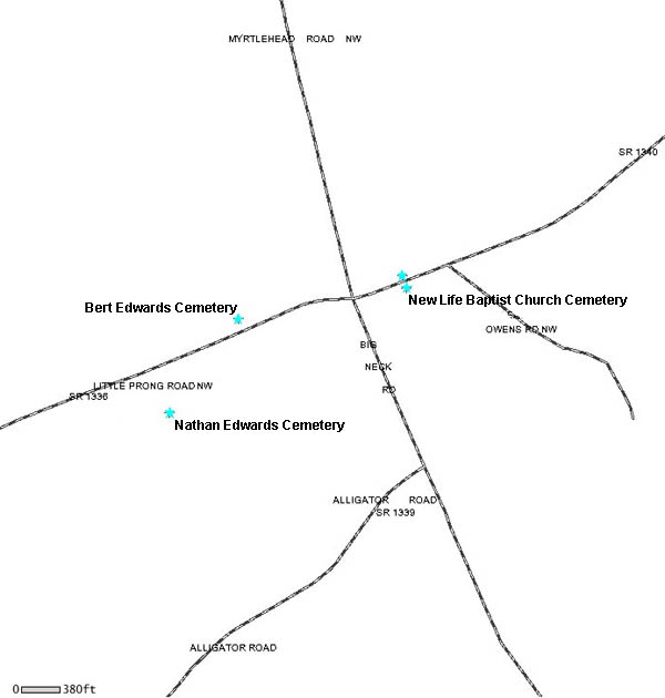
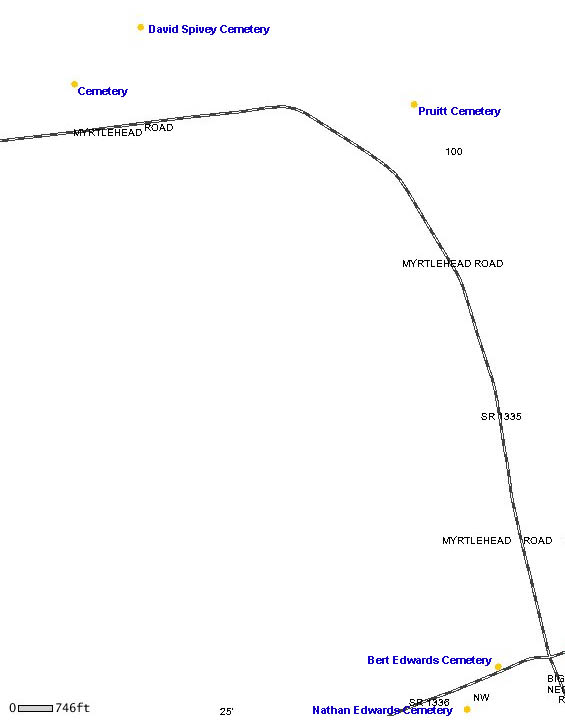
Bert Edwards
Cemetery, Ash
Little Prong Road
street
map
Brunswick County GIS
map |
Nathan Edwards Cemetery, Ash
Little Prong Road
Note: Tax Map #104
(Timeline: 1899-1920; 4 graves)
street
map
Brunswick County GIS
map |
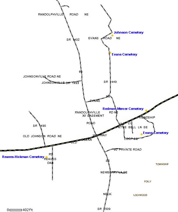
Evans Cemetery,
Ash
Ready Branch Way
Note: Tax Map #75
online transcription
street
map
Brunswick County
GIS map |
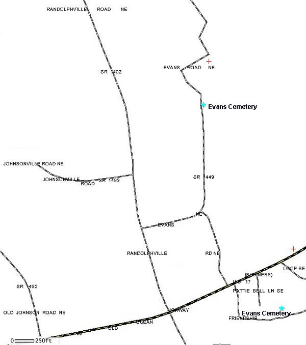
.Evans Cemetery, Bolivia
Evans Road
(Timeline 1966-1968; 2 graves)
street
map
Brunswick County GIS map |
.Evans Cemetery,
Bolivia
Friendship Loop Road
street map
Brunswick County GIS map |
Faith Community Chapel Cemetery, Supply
Sunset Harbor Road
online
transcription
street
map
Brunswick County
GIS map |
Faith Free Will
Baptist Church Cemetery, Leland
Parker Trail
online transcription
street
map
topographic
map |
Farmers Chapel Baptist Church Cemetery,
Maco
Farmers Chapel Road and Maco Road
online transcription
street
map
topographic
map |
Fields Cemetery,
Leland
Fields Cemetery Road
online transcription
street
map
Brunswick County GIS map |
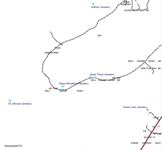
Forest Lawn Cemetery, Bolivia
off of Hwy 17
street
map
topographic
map
Brunswick County GIS
map |
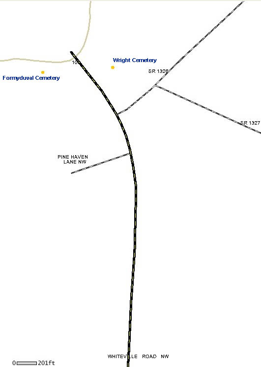
Formyduval
Cemetery
Whiteville Road
Note: Tax Map #102
(Timeline: 1895-1966; 7 graves)
street
map
Brunswick County GIS map |
Frink Cemetery at The Pearl Golf Course,
Calabash
Pearl Boulevard
online transcription
street
map |
Frink/Hill
Cemetery, Shallotte
Hewett Farms Road
street
map
Brunswick County GIS
map |
David Isaah Fulford Cemetery, Supply
Bowman Street
(3 graves; wooden markers only)
street
map |
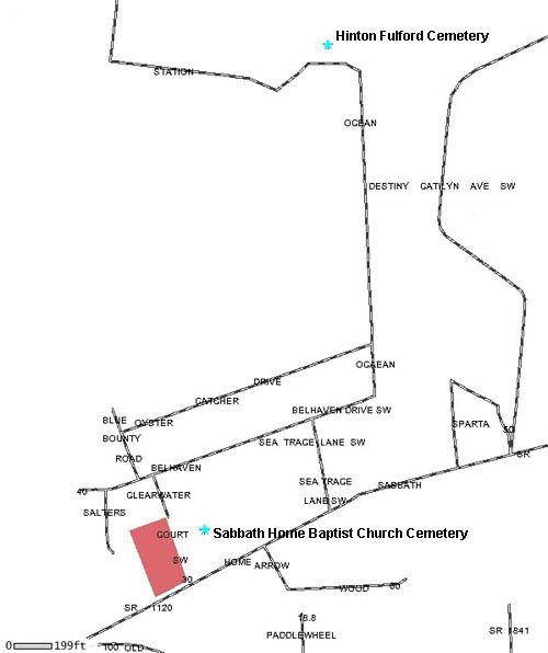
Hinton Fulford
Cemetery, Holden Beach
Ocean Station Road
(11 graves, no marked graves)
street
map
Brunswick County GIS
map |
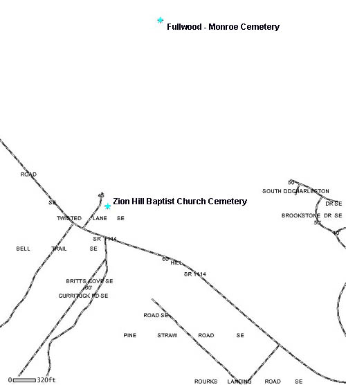
Fullwood - Monroe Cemetery, Supply
Zion Hill Road
Note: Tax Map #201
street
map
Brunswick County GIS Map |
Willie
Fulwood/Slave Cemetery, Varnamtown
Stone Chimney Road
Star News Online article
Brunswick County GIS
map |
|
Gainey Cemetery, Leland
Breman Lane
street
map
Brunswick County GIS map |
Galloway
Cemetery, Bolivia
Galloway Road
online transcription
street
map
Brunswick County GIS
map |
JD Galloway Cemetery, Bolivia
Gilbert Road
Note: Tax Map #170
(2 graves)
street
map
Brunswick County GIS map |
Galloway
Cemetery, Bolivia
Island Drive
online transcription
street
map
Brunswick County GIS
map |
Galloway Cemetery, Supply
Big Macedonia Road
online transcription
street
map
topographic
map
Brunswick County GIS
map |
Galloway
Cemetery, Supply
AKA Russ Cemetery
Green Swamp Road
online transcription
street
map
Brunswick County GIS
map |
Galloway Cemetery, Supply
Green Swamp Road
street map
topographic
map
Brunswick County GIS
map |
Ganey Cemetery,
Leland
Lewis Swamp Road
Note: Tax Map #68
street
map
Brunswick County GIS map |
Ganey Cemetery, Leland
behind 8627 Orchard Loop Road
street map
Brunswick County GIS map |
Ganus Cemetery,
Longwood
Etheridge Road
street
map
topographic
map |
Gause Cemetery, Winnabow
Cherrytree Drive
(Timeline: 1826; 1 marked grave)
street
map
Brunwsick County GIS map |
Gause's Tomb,
Shallotte
Hale Swamp Road
photos
History of Gause's Tomb
street
map
Brunswick County GIS map |
Gaylord Cemetery, Leland
Northwest Road
Note: Tax Map #8
(1 marked grave)
street
map
Brunswick County GIS map |
Georgetown -
Holden Cemetery, Supply
Stanley Road
street
map
topographic
map
Brunswick County GIS
map |
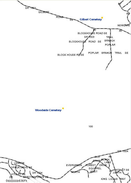
Gilbert Cemetery, Bolivia
Gilbert Road
online transcription
street
map
Brunswick County
GIS map |
Gore Cemetery,
Ash
Pea Landing Road
Note: Tax Map #210
(2 graves)
street
map
Brunswick County GIS
map |
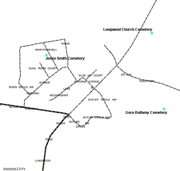
Gore - Bellamy Cemetery, Longwood
Russtown Road
online transcription
street map
Brunswick County GIS
map |
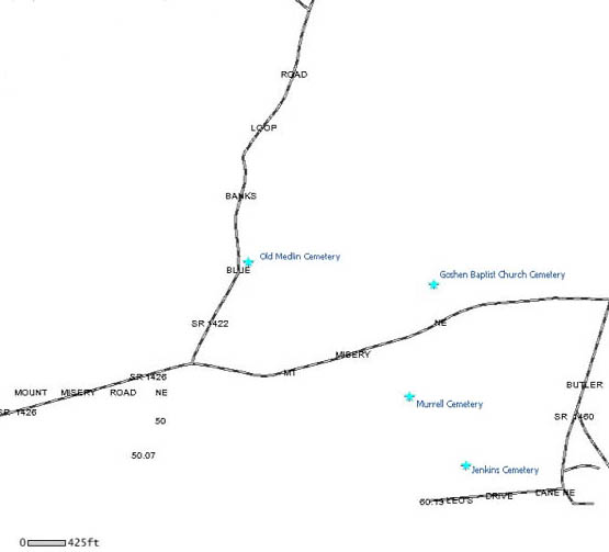
Goshen Baptist
Church Cemetery, Leland
Mount Misery Road
street
map
Brunswick County GIS
map |
Gospel Center Baptist Church Cemetery,
Supply
Stanley Road
street
map
Brunswick County GIS
map |
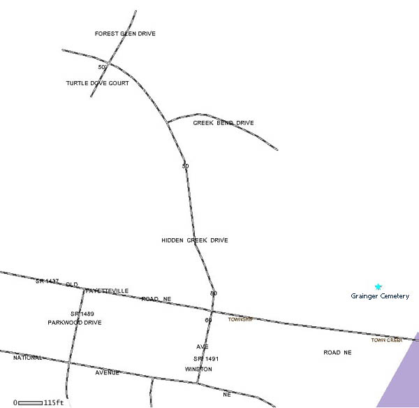
Grainger
Cemetery, Leland
Old Fayetteville Road
street
map
Brunswick County GIS
map |
Greenbanks Cemetery, Leland
Keith Road
Note: Tax Map #1
street
map
Brunswick County GIS map |
Greer Cemetery,
Bolivia
AKA Williams Cemetery
Carney's Branch Trail
street
map
topographic
map
Brunswick County GIS
map |
Griffin Cemetery, Ash
(AKA Bozeman-Griffin Cemetery)
Grifin Cemetery Road
online
transcription
street
map
topographic
map |
Grimes-Smith
Cemetery, Winnabow
Daws Creek Road
Note: Tax Map #100
(Timeline: 1854-1920)
information about
cemetery from email
street
map
Brunswick County
GIS map |
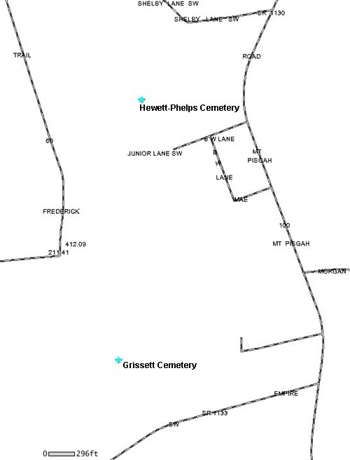
Grissett Cemetery, Supply
Stone Chimney Road
Note: Tax Map #184
online transcription
street map
Brunswick County GIS
map |
Grissett
Cemetery, Supply
Empire Road
(2 graves; brick remains only)
photos
street
map
Brunswick County GIS
map |
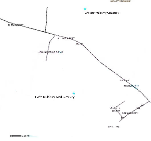
Grissett-Mulberry Cemetery, Shallotte
Mulberry Road
street
map
Brunswick County GIS
map |
Gurganus
Cemetery, Shallotte
Cemetery Way
online transcription
street
map
topographic
map |
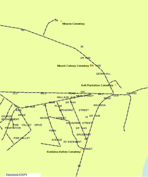
.Hall Plantation Cemetery, Leland
Cedar Hill Road & Bluff Hill Road; near
Railroad
(6 graves)
street
map
Brunswick County GIS
map |
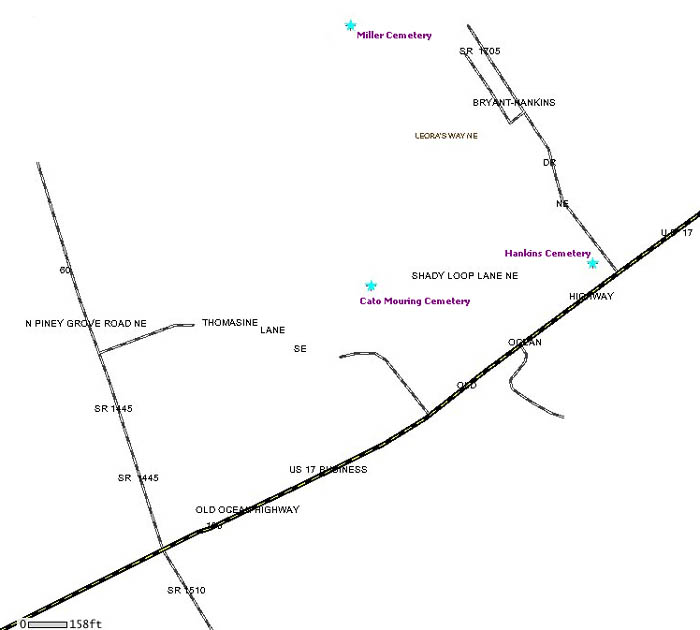
Hankins Cemetery,
Bolivia
Bryant-Hankins Drive
(Timeline: 1936-2006; 7 graves)
street
map
Brunswick County GIS map
|
Harvell Cemetery, Bolivia
Midway Road
online transcription
street
map
topographic
map
Brunswick County GIS map
|
Haw Hill
Cemetery, Leland
AKA Davis Cemetery
River Road
Note: Tax Map #101
street
map
Brunswick County GIS
map |
Henderson Cemetery, Ocean Isle Beach
Pharview Drive
online transcription
street
map
Brunswick County GIS map
|
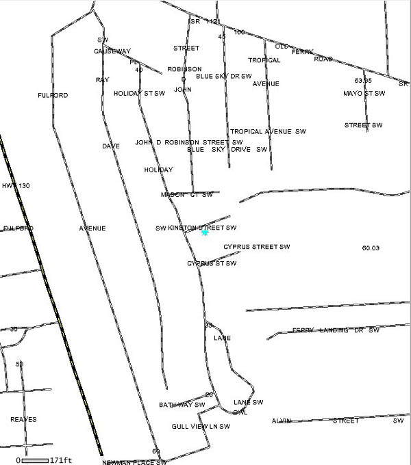
Joseph Hewett
Cemetery, Holden Beach
Kinston Street
street
map
Brunswick County GIS map
|
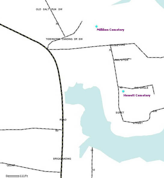
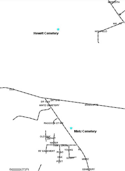
Hewett Cemetery, Shallotte
Egret Street
online transcription
street
map
Brunswick County GIS map
|
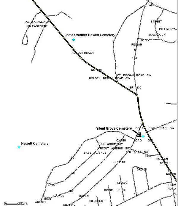
James Walker
Hewett Family Cemetery, Shallotte
Holden Beach Road
online transcription
street
map
topographic
map
Brunswick
County GIS map |
Hewett Cemetery, Shallotte
Old Shallotte Road
online
transcription
street
map
Brunswick County GIS map
|
Allen Hewett
& wife Gravesite; Supply
Green Swamp Road
Note: Tax Map #137
(2 unmarked graves)
street
map
Brunswick County GIS
map |
Hewett Cemetery, Supply
Ouida Trail
street
map
Brunswick
County GIS map |
Raleigh B Hewett
Cemetery, Supply
RB Lane
street
map
Brunswick County GIS
map |
|
|
Hewett-Phelps
Cemetery, Supply
Junior Lane
(2 marked graves; 4 unmarked graves)
street map
Brunswick County GIS
map |
|
|
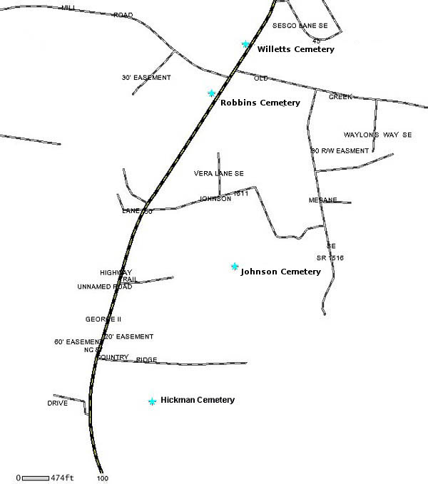
Hickman Cemetery,
Calabash
AKA Whispering Pines Cemetery
Calabash Road
online transcription
street
map
Brunswick
County Register of Deeds map |
|
|
Holden Cemetery,
Holden Beach
Carsten's Way
(Timeline: 1857; 3 graves)
street
map |
Holden Family Cemetery, Supply
Stone Chimney Road
online
transcription
street
map
topographic
map
Brunswick County
GIS map |
Holy Bethel
Cemetery, Ash
Ocean Hwy West 17
street
map |
|
|
Hooper Cemetery,
Leland
Hooper Road
street map
Brunswick County GIS
map |
Claris Horne Gravesite, Calabash
Beach Drive
online transcription
street
map |
Hughes Cemetery,
Shallotte
Friendship Road
(2 marked graves; 3 unmarked graves)
street
map
Brunswick County GIS map
|
|
|
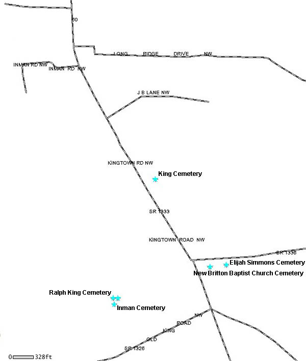
Inman Cemetery,
Ash
Old King Road
online transcription
street
map
topographic
map |
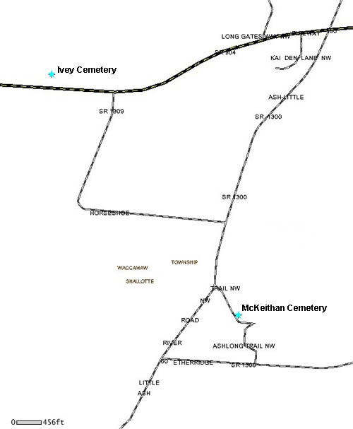
Ivey Cemetery, Longwood
Pireway Road
Note: Tax Map #161
(2 graves)
street
map
Brunswick County
GIS map |
|
|
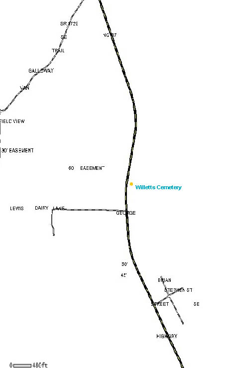
Jacobs Cemetery, Leland
AKA Willetts Cemetery
Northwest Road between 4008 and 4010
online transcription
street
map
Brunswick County GIS
map |
Jenkins Cemetery,
Leland
Leo's Drive
street map
Brunswick County GIS
map |
Jenkins Cemetery, Leland
Rock Creek Road
Note: Tax Map #69
(1 grave)
street
map
Brunswick County GIS
map |
Jennies Branch
Baptist Church Cemetery, Ocean Isle Beach
5256 Beach Drive
street map
topographic
map
Brunswick County GIS
map |
Johnson Cemetery, Bolivia
Evans Road
street
map
Brunswick County GIS map |
Johnson Cemetery,
Bolivia
Johnson Trail
street
map
Brunswick County GIS
map |
Johnson/Brown Cemetery, Leland
Saw Mill Road
(9 graves)
street
map
topographic
map
Brunswick County GIS
map |
Johnson Cemetery,
Ocean Isle Beach
Todd Road
online transcription
street
map |
Johnson Cemetery, Winnabow
Bell Swamp Road
Note: Tax Map #110
street
map
Brunswick County GIS
map |
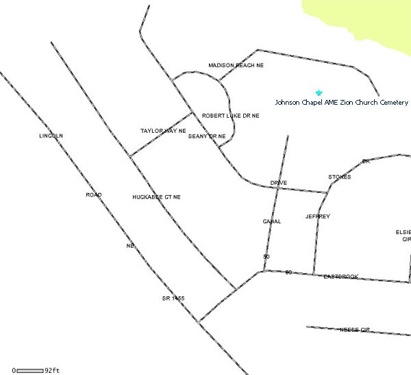
Johnson Chapel
AME Zion Church Cemetery, Leland
AKA Oak Lawn Cemetery
Canal Drive
street
map
Brunswick County
GIS map |
Jones Cemetery, Leland
AKA Holy Covenant United Holy Church Cemetery
Snowfield Road
street
map |
Jordan Cemetery,
Leland
AKA Watson Cemetery
Maco Road
Note: Tax Map #35
street
map
Brunswick County GIS
map |
Jordon Cemetery, Leland
AKA Brown Cemetery
Blue Banks Loop Road
Note: Tax Map #5
(5 graves)
street
map
Brunswick County GIS map |
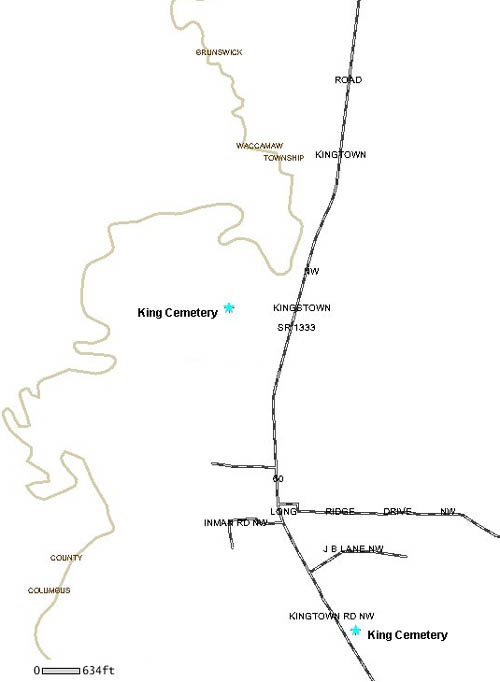
King Cemetery,
Ash
Kingtown Road
street map
Brunswick County GIS map |
King Cemetery, Ash
AKA Indigo Field Cemetery
Kingtown Road
(6 graves)
street
map
Brunswick County GIS map |
Ralph King
Cemetery, Ash
5914 Old King Road
street
map
Brunswick County GIS map |
King Cemetery, Leland
Bluff Drive
street
map
Brunswick County GIS map |
Lancaster
Cemetery, Supply
Turnpike Road
online transcription
street
map |
Law Cemetery, Bolivia
Law Road
(1 grave )
street
map
Brunswick County GIS map |
Lebanon Baptist
Church Cemetery, Winnabow
7342 Funston Road
street
map
topographic
map
Brunswick County
GIS map |
Lehew Cemetery, Shallotte
AKA Chapel Hill Cemetery
Hwy 17
street
map
topographic
map |
Leland Baptist
Church Cemetery, Leland
Village Road
street
map
Brunswick County GIS
map |
Lennon Cemetery, Bolivia
Old Lennon Road
Note: Tax Map #169
(6 graves)
street
map
topographic
map |
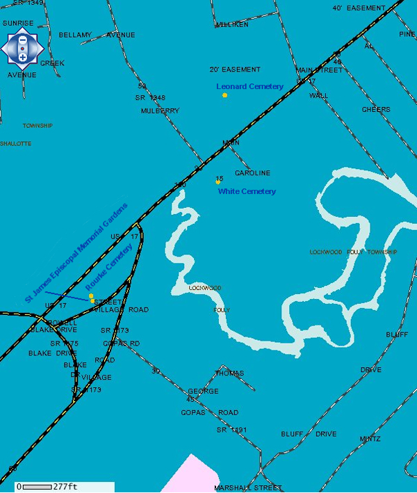
Leonard Cemetery,
Shallotte
Hwy Business 17
online transcription
street
map
topographic
map |
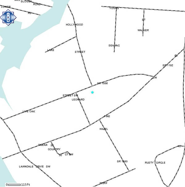
Leonard Cemetery, Shallotte
Live Oak Street
street map
Brunswick County
GIS map |
Lesh Cemetery,
Bolivia
Gilbert Road
(2 graves)
street
map
topographic
map
Brunswick County GIS map |
Lewis (Prior) Cemetery, Bolivia
Antenna Farm Road
Note: Tax Map #171
street
map
Brunswick County GIS map |
Lilliput
Cemetery, Winnabow
River Road
(7 graves)
street
map
Brunswick County GIS
map |
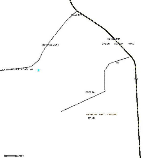
Christopher C Little Cemetery, Ash
Egypt Road
Note: Tax Map #78
online
transcription
street
map
Brunswick County GIS
map |
Little Prong
Cemetery, Ash
Little Prong Road
street map
Brunswick County GIS
map |
Live Oak Cemetery, Hickman's Crossroads
Hickman Road
online
transcription
street
map
topographic
map |
Lock Cemetery,
Leland
Hooper Lane
Note: Tax Map #6
street
map
Brunswick County GIS
map |
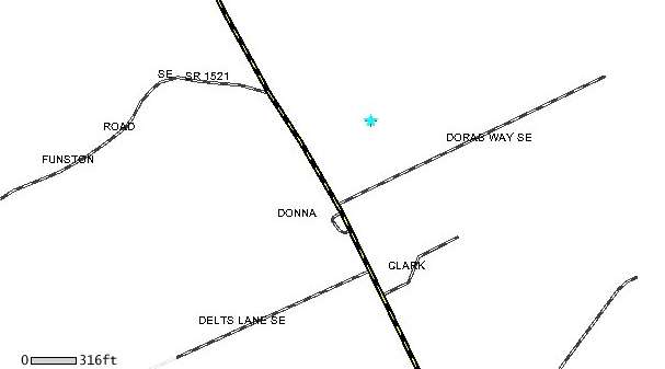
Long Cemetery, Ash
Ash-Little River Road
street
map
topographic
map
Brunswick County GIS map |
Long Cemetery,
Ash
Ash-Little River Road
Note: Tax Map #146
(8 graves)
street
map
Brunswick County GIS map |
|
|
Long Cemetery,
Supply
Edgarwood Way
(2 graves)
street map
Brunswick County GIS
map |
|
|
Ludlum Cemetery,
Longwood
Whiteville Road/Hwy 130
Note: Tax Map #147
(1 marked grave & 3 unmarked graves)
street
map
Brunswick County GIS map |
Ludlum Cemetery, Longwood
Whiteville Road/Hwy 130
Note: Tax Map #147
street
map
Brunswick County GIS map |
|
|
|
|
Oak Grove Baptist Church
Cemetery, Holden Beach
1356 Holden Beach Road
online
transcription
street
map
topographic
map
Brunswick County GIS
map |
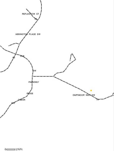
Cemetery at Ocean
Ridge Plantation, Sunset Beach
AKA Grissett - Frink Cemetery
Dartmoor Way
online transcription
street
map
topographic
map
Brunswick County
GIS map |
Ocean View Pentecostal FWB Church
Cemetery, Supply
1738 Stanbury Road
online
transcription
street
map
topographic
map |
Old Medlin
Cemetery, Leland
Blue Banks Loop Road
Note: Tax Map #9
(2 unmarked graves)
street
map
Brunswick County GIS
map |
Old Northwest Cemetery, Leland
Northwest Road
Note: Tax Map #8
street
map
Brunswick County GIS map |
Old Piney Grove
Cemetery, Winnabow
Green Hill Road
street
map
topographic map
Brunswick County GIS map |
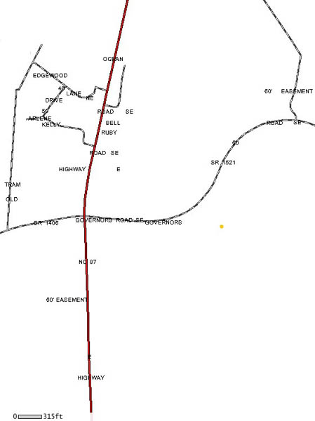
Old Saint Mary's AME Church Cemetery,
Winnabow
Governor's Road
(9 marked graves; 5 unmarked graves)
street
map
Brunswick County GIS
map |
Old Smithville
Burying Ground, Southport
near Nash Street
online transcription
street
map
topographic
map |
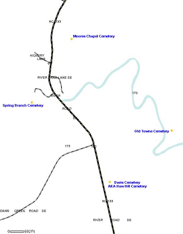
Old Towne Cemetery, Leland
River Road
Note: Tax Map #87
street
map
Brunswick County GIS
map |
Old Willetts
Cemetery, Winnabow
Daws Creek Road
Note: Tax Map #99
street
map
Brunswick County GIS
map |
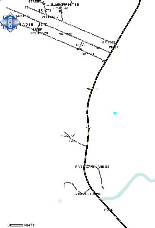
Orton Plantation Cemetery, Winnabow
Highway NC 133
online transcription
street
map
topographic
map |
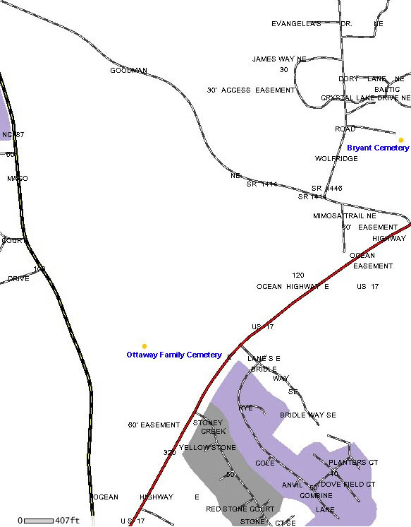
Ottaway Family
Cemetery, Maco
Maco Road
Note: Tax Map #57
street map
Brunswick County GIS
map |
Parker Cemetery, Shallotte
AKA Brooks Cemetery
Ocean Isle Beach Road
online
transcription
street
map
topographic
map
Brunswick County GIS
map |
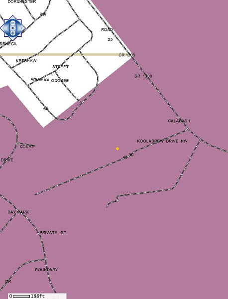
Patterson
Cemetery, Calabash
Koolabrew Drive
online transcription
street
map
Brunswick County
GIS map |
Peace Memorial Baptist Church Cemetery,
Winnabow
5811 Ocean Highway East
street
map
topographic
map
Brunswick County GIS
map |
Peadrick
Cemetery, Leland
Maultsby Road
Note: Tax Map #83
(timeline: 1880s, 5 graves)
street
map
Brunswick County GIS
map |
Perkinsville Missionary Church Cemetery,
Leland
Goose Neck Road
street
map
topographic
map
Brunswick County GIS map |
Phelps Cemetery,
Supply
Eastwind Drive
street
map
Brunswick County GIS
map |
Pierce Cemetery, Ocean Isle Beach
Beach Drive (Hwy 179)
online transcription
street
map
topographic
map |
Piggott Cemetery,
Shallotte
Buttercup Lane
street
map
topographic
map
Brunswick County GIS
map |
Piney Grove Community Cemetery, Bolivia
Galloway Road
Note: Tax Map #123
street
map
Brunswick County GIS map |
Piver Cemetery,
Ash
Whiteville Road (Hwy 130)
(7 graves)
street map
Brunswick County GIS map |
Pleasant View Cemetery, Sunset Beach
off of Hwy 179
online
transcription
street
map
topographic
map |
Point Repose
Cemetery, Leland
Blue Banks Loop Road
Note: Tax Map #6
(1 marked grave; 4 unmarked graves)
street
map
Brunswick County GIS
map |
Potter Cemetery, Leland
Northwest Road
(2 graves)
street
map
Brunswick County GIS
map |
Andrew Jackson
Potter Cemetery, Leland
Rock Creek Road
online transcription
street
map
Brunswick County GIS
map |
Benjamin Potter Cemetery, Leland
Town Creek Road
online transcription
street
map
Brunswick County GIS
map |
John M Potter
Cemetery, Leland
Town Creek Road
(Timeline: 1700s-1896; 2 broken stones)
street
map
Brunswick County GIS map |
Mary Jane Potter Gravesite, Leland
Rock Creek Road
Note: Tax Map #69
online transcription
street
map
Brunswick County GIS map |
Miles Potter
Cemetery, Leland
Town Creek Road
(Timeline: 1848; 7 graves)
online transcription
(partial)
street map
Brunswick County GIS
map |
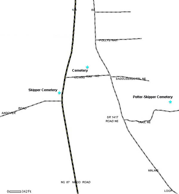
Potter-Skipper Cemetery, Maco
Gully Creek Trail off of Malmo Loop Road
online transcription
street
map
Brunswick County GIS
map |
Potter-Smith
Cemetery, Leland
Northwest Road
online transcription
street
map
Brunswick County GIS
map |
Potter's Field Cemetery, Southport
River Road
street
map
Brunswick County GIS map |
Price Cemetery,
Southport
River Road
online transcription
street
map
Brunswick County GIS map |
Price Family Cemetery, Leland
Friendly Lane
street
map
Brunswick County GIS map |
Prospect Baptist
Church Cemetery, Supply
Makatoko Road
online transcription
street
map
topographic
map
Brunswick County
GIS map |
Pruitt Cemetery, Ash
Myrtlehead Road
Note: Tax Map #76
(2 marked graves; 8 unmarked graves)
street
map
Brunswick County GIS map |
|
|
Rabon Cemetery, Winnabow
Green Hill Road
online transcription
street
map
Brunswick County GIS map
topographic
map |
Randolph
Cemetery, Bolivia
Tobe's Road
street
map
topographic
map
Brunswick County GIS
map |
Reaves Cemetery, Ocean Isle Beach
Old Georgetown Road
street
map
Brunswick County GIS map
|
Reaves-Hickman
Cemetery, Bolivia
Dan Reeves Road
street
map
Brunswick County GIS map
|
Reeves Chapel Cemetery, Leland
Cedar Hill Road
street
map
Brunswick County GIS map
|
Register
Cemetery, Shallotte
Todd Road
online transcription
street
map
topographic
map
Brunswick County
GIS map |
Reynold Cemetery, Winnabow
Bell Swamp Connection
streep
map
topographic
map
Brunswick County
GIS map |
Reynolds
Cemetery, Bolivia
Hwy 87
online transcription
street
map
Brunswick County GIS
map |
Royal Governor Nathaniel Rice Gravesite,
Winnabow
Dove Haven Lane
Note: Tax Map #70
street
map
Brunswick County GIS map
|
Roach Cemetery,
Supply
AKA Lancaster Cemetery
Robinson Drive
(Timeline: 1872-1957; 29 graves)
street
map
Brunswick County GIS map
|
Robbins Cemetery, Bolivia
Hwy 87
street
map
topographic
map
Brunswick County GIS
map |
Robbins Cemetery,
Leland
AKA Robinson Cemetery
Cedar Hill Road
street
map
Brunswick County GIS map
topographic
map |
Robbins Cemetery, Leland
Behind 110 Andrew Jackson Highway
street map
Brunswick County GIS
|
Robbins Cemetery,
Leland
Blue Banks Loop Road
Note: Tax Map #6
(10 graves)
street
map
Brunswick County GIS
map |
Robbins Cemetery, Leland
Green Loop Road
(Timeline: 1884-1931)
street
map
Brunswick County GIS
map |
Robbins-Hatten
Cemetery, Leland
Navassa Road
(Timeline: 1963-present; 6 graves)
street
map
Brunswick County GIS
map |
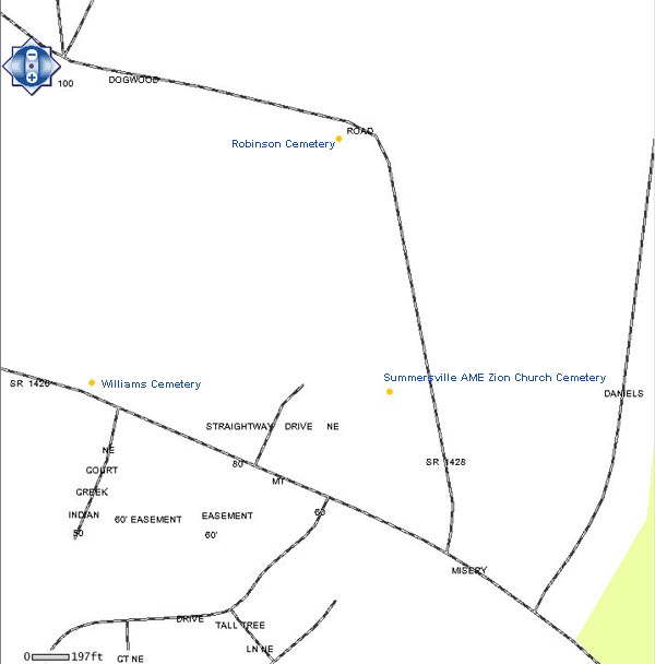
Robinson Cemetery, Leland
AKA Williams/Southerland Cemetery
Dogwood Road
street
map
topographic
map
Brunswick County GIS
map |
Eliza Robinson
Cemetery, Shallotte
Holden Beach Road
online transcription
street
map |
Robinson Cemetery, Supply
Seashore Road
online
transcription
street
map
topographic
map |
Ross Cemetery,
Ash
New Britton Loop Road
online transcription
street
map
Brunswick County GIS map
|
Rourke Cemetery, Shallotte
Powell Street
street map
Brunswick County GIS map
|
Rowell Cemetery,
Leland
Northwest Road
(two unmarked graves; others moved to Goshen
Church)
street
map
Brunswick County GIS map
|
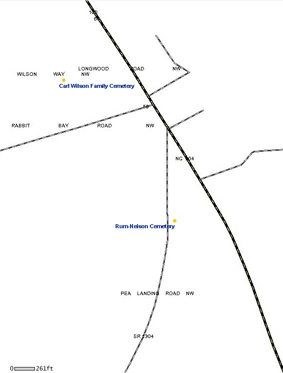
Rum-Nelson Cemetery, Ash
Pea Landing Road
street map
Brunswick County GIS
map |
Rusher Bay
Cemetery, Shallotte
AKA Hill Cemetery
Hale Swamp Road
street
map
topographic
map
Brunswick County GIS map
|
Larry Russ Family Cemetery, Longwood
Russ Road
street
map
Brunswick County GIS map
|
Rutland AME
Chapel Cemetery, Bolivia
Midway Road
street
map
topographic
map
Brunswick County
GIS map |
Sabbath Home Baptist Church, Supply
990 Sabbath Home Road
online
transcription
street
map
topographic
map
Brunswick County
GIS map |
Saint James AME
Zion Church Cemetery, Leland
27 Old Town Creek Road
street
map
topographic
map |
Saint James Episcopal Memorial Gardens,
Shallotte
4941 Main Street
street
map
Brunswick County GIS map
|
Saint Mary
Baptist Church Cemetery, Winnabow
Ocean Highway East
street
map
Brunswick County GIS map
Brunswick
County Register of Deedsmap
|
Saint Paul's Catholic Church Cemetery,
Maco
Maco Road
online
transcription
street
map
Brunswick County GIS map
|
Saint Phillips
Cemetery, Winnabow
St Phillips Road
street
map
Brunswick County GIS
map |
Saint Thomas Cemetery, Leland
Chappell Loop Road
street
map
topographic
map |
Seaside Cemetery,
Sunset Beach
Seaside Road and Live Oak Drive
Who
is buried in the small cemetery on Seaside
Road in Sunset Beach (myreporter.com)
street
map
Brunswick County
GIS map |
Riley Sellers Cemetery, Supply
Turnpike Road
online
transcription
street
map
Brunswick County GIS
map |
Shady Rest
Cemetery, Bolivia
Brown Road
street
map
Brunswick County GIS
map |
Sharon United Methodist Church Cemetery,
Supply
2030 Holden Beach Road
online
transcription
street
map
topographic
map |
Shell Point
Baptist Church, Shallotte
Canna Place
(Timeline: 1999-Present; 4 graves)
street
map
Brunswick County GIS
map |
Shiloh United Methodist Church Cemetery,
Maco
1874 Maco Road
street map
Brunswick County GIS map
|
Silent Grove
Cemetery, Supply
Oxpen Rd, off of Hwy 130
online transcription
street
map
topographic
map
Brunswick County
GIS map |
Simmons Cemetery, Ash
Kingtown Road
Note: Tax Map #74
(Timeline: 1943-1967; 5 graves)
street
map
Brunswick County GIS
map
topographic
map |
Benjamin Simmons
Cemetery, Supply
Mt Pisgah Road
Note: Tax Map #167
street map
Brunswick County GIS
map |
Elijah Simmons Family Cemetery, Ash
Little Prong Road
online transcription
street
map
Brunswick County GIS
map
Brunswick
County Register of Deeds map |
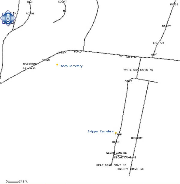
Skipper Cemetery,
Leland
Bear Trap Road
online transcription
street
map
Brunswick County GIS
map |
Skipper Cemetery, Leland
Quail Hollow Road & Mt Misery Road
street map
Brunswick County GIS
map |
Skipper Cemetery,
Leland
Northwest Road
(10 graves)
street
map
Brunswick County GIS
map |
Skipper Cemetery, Sandy Creek
(AKA Sandy Creek Cemetery)
Hwy 87/Maco Road
online transcription
street
map
topographic
map
Brunswick County
GIS map |
Smith Cemetery,
Ash
Ash-Little River Road
street
map
topographic
map
Brunswick
County Register of Deeds map
Brunswick County GIS
map |
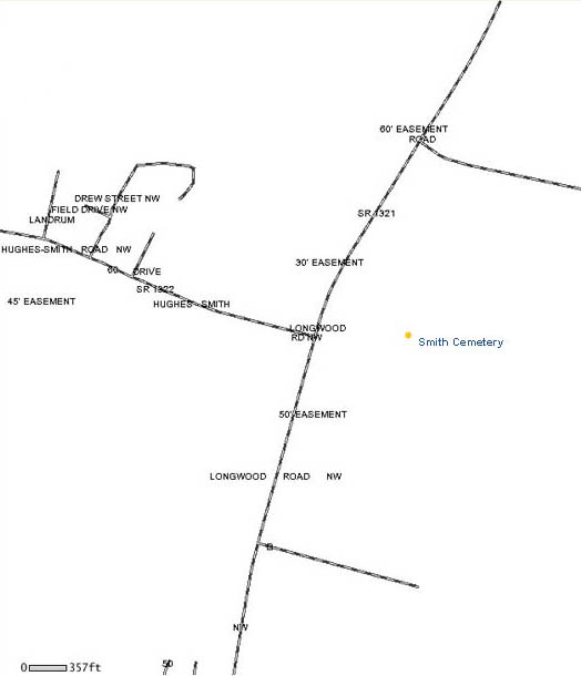
Smith Cemetery, Ash
Longwood Road
Note: Tax Map #178
street
map
Brunswick County GIS map
|
Azor James Smith
Cemetery, Ash
Longwood Road
street
map
topographic
map
Brunswick County GIS map
|
Smith Cemetery, Ash
Our Paradise Lane
Note: Tax Map #102
street
map
Brunswick County GIS map
|
Smith Cemetery,
Ash
AKA Simmons Cemetery
Hwy 130/Whiteville Road
online transcription
street
map
topographic
map
Brunswick
County Register of Deeds map |
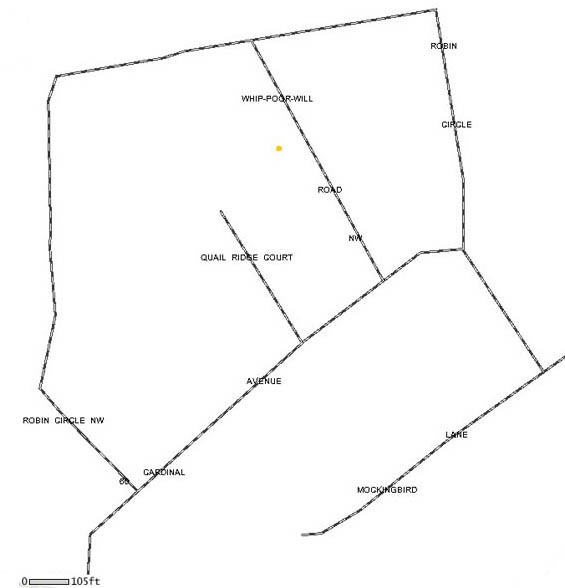
Jesse Smith Cemetery, Longwood
Whip-poor-will Road
(6 graves)
street
map
Brunswick County GIS map
|
John N Smith
Cemetery, Southport
Leonard Street
street
map
topographic
map |
Sneed Cemetery, Leland
Old Fayetteville Road
online transcription
street
map
Brunswick County
GIS map |
.David Spivey
Cemetery, Ash
Myrtlehead Road
(Timeline: 1978-1984; 2 marked graves; 2
unmarked)
street map
Brunswick County GIS map
|
GF Spivey Cemetery, Supply
Green Swamp Road
online
transcription
street map
Brunswick County GIS
map |
Spring Branch
Cemetery, Leland
River Road
Note: Tax Map #86
street
map
Brunswick County
GIS map |
Spring Green Missionary Baptist Church
Cemetery, Leland
Port Royal Road
street
map
Brunswick County GIS
map |
Stanaland
Cemetery, Sunset Beach
AKA Metcalf-Stanaland Cemetery
Clubhouse Road at Sea Trail Plantation
street
map
Brunswick County GIS
map |
Stanley Cemetery, Ash
AKA Stanley-Gause Cemetery
Johnnie Mae Road off of Ash-Little River Road
street
map
topographic
map
Brunswick County GIS map
|
Stanley Cemetery,
Bolivia
Bypass Way
street
map
topographic
map
Brunswick County GIS
map |
Stanley Cemetery, Shallotte
Brierwood Golf Course
online
transcription
street
map
topographic
map
Brunswick County GIS
map |
Stanley Cemetery,
Shallotte
AKA Angela Faye Cemetery
McMilly Road
street
map
topographic
map
Brunswick County GIS
map |
Stanley - Gore - Prince Cemetery, Ash
Ash-Little River Road
Note: Tax Map #193
online
transcription
street
map
topographic
map
Brunswick County GIS
map |
Stevens Cemetery,
Bolivia
Hwy 211
(4 graves)
street
map
Brunswick County GIS
map |
Sue Cemetery, Maco
AKA Chinnis Cemetery
Trucking Lane
online
transcription
street
map
topographic
map |
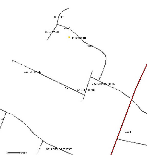
Richard Sullivan
Family Cemetery, Winnabow
Victoria Lane
online transcription
street
map
Brunswick County GIS
map |
|
|
Summersville AME
Zion Church Cemetery, Leland
2991 Dogwood Road
street
map
topographic
map
Brunswick County GIS
map |
|
|
Swain Family
Cemetery, Southport
off of Hwy 211
online transcription
street
map |
Sykes Cemetery, Leland
off of Goose Neck Road
street
map
topographic
map
Brunswick County GIS map
|
|
|
Tharp Cemetery, Town Creek
Town Creek Road
online transcription
street
map
Brunswick County GIS map |
James Tharp
Cemetery, Winnabow
Bell Swamp Road
Note: Tax Map #110
online transcription
street
map
Brunswick County GIS
map |
Thomas Cemetery, Ash
Worrell Lane off Pea Landing Road
(Timeline: 1896-1904; 2 graves)
street
map
Brunswick County GIS map |
Thomas Cemetery,
Ash
Pea Landing Road
street
map
Brunswick County GIS map |
Thomas Family Cemetery, Calabash
Trader's Lane Extension
street
map
topographic
map
Brunswick County GIS
map |
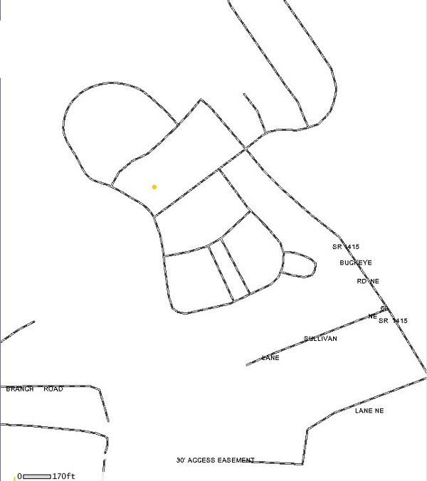
Thomas - Simmons
Cemetery, Leland
Buckeye Road
(Timeline: 1885-1976; 9 marked graves; 1
unmarked)
street
map
Brunswick County
GIS map |
Thorton Cemetery, Leland
Andrew Jackson Hwy 74/76
(Timeline: 1852; 2 marked graves; 2 unmarked
graves; located in the woods/part of
junkyard/goat pen)
street
map
Brunswick County
GIS map |
Town Creek Church
Cemetery, Leland
832 Green Hill Road NE
online transcription
street
map
topographic
map |
Troy Cemetery, Leland
Idle Way
Note: Tax Map #17
(4 graves)
street
map
Brunswick County
GIS map |
Union Chapel
Cemetery, Supply
2039 Boones Neck Road
online transcription
street
map
topographic
map |
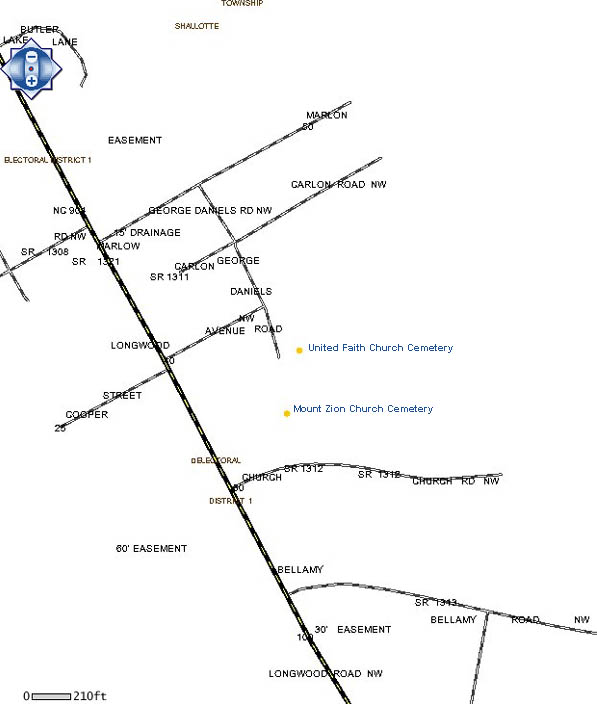
United Faith Baptist Church Cemetery,
Longwood
Mount Zion Church Road
street
map
Brunswick County GIS map |
Varnam Cemetery,
Supply
Stanley Road
street
map
Brunswick County GIS
map |
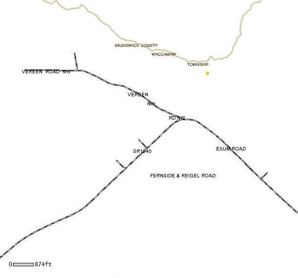
Vereen Cemetery, Ash
Vereen Road
Note: Tax Map #77
(Timeline: 1886; 2 graves)
street
map
Brunswick County GIS
map |
|
|
Ward Cemetery, Ash
Daniel Butler Road off of Hwy 904
street
map
topographic
map
Brunswick County GIS
map |
Ward Cemetery,
Leland
Zion Church Road
online transcription
street
map
Brunswick County
GIS map |
Waters Cemetery, Leland
between 2717 and 2729 Cedar Hill Road
street
map
Brunswick County GIS map |
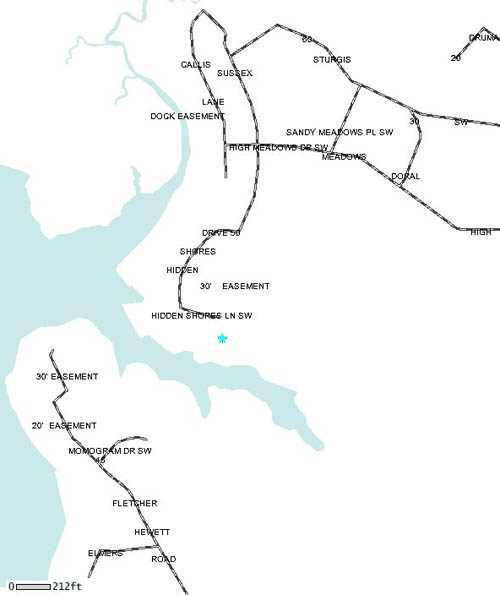
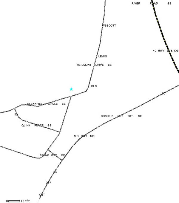
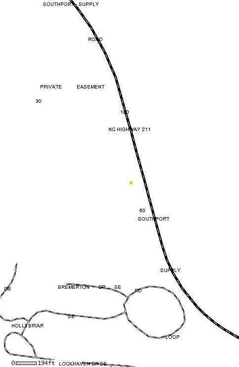
Wescott Cemetery,
Southport
Glennfield Circle
street map
Brunswick County
GIS map |
Westmore Cemetery, Leland
Blue Banks Loop Road
Note: Tax Map #6
street
map
Brunswick County GIS
map |
Weston Cemetery,
Leland
Cedar Hill Road
street map
topographic
map
Brunswick County GIS
map |
White Cemetery, Shallotte
Middle Dam Road
Note: Tax Map #214
online
transcription
street
map
Brunswick County GIS
map |
White Cemetery,
Shallotte
behind 4807 Main Street
(Timeline: 1886-1937; 8 graves)
street
map
Brunswick County GIS
map |
White Cemetery, Winnabow
Cherrytree Road
(1
grave)
street
map
Brunwsick County GIS map |
Willetts
Cemetery, Bolivia
Hwy 87
online transcription
street
map
Brunswick County GIS
map |
Willetts Cemetery, Winnabow
Daws Creek Road
(Timeline: 1898-1936; 3 graves)
street
map
Brunswick County GIS
map |
Willetts Family
Cemetery, Bolivia
Hwy 87
online transcription
street
map
topographic
map
Brunswick County
GIS map |
Williams Cemetery, Bolivia
Randolphville Road
(10 graves)
street
map
Brunswick
County Register of Deeds map
Brunswick County GIS
map |
Williams
Cemetery, Supply
Southport-Supply Road
Note: Tax Map #168
(6 graves)
street
map
Brunswick County
GIS map |
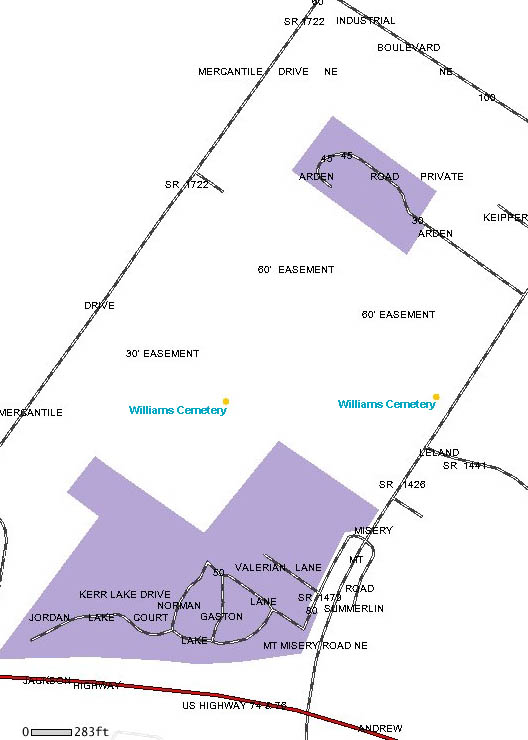
Williams Cemetery, Leland
Mt Misery Road
street
map
topographic
map |
Williams
Cemetery, Leland
Mt Misery Road
street
map
topographic
map
Brunswick County
GIS map |
Williams Cemetery, Leland
Mt Misery Road, across from 9281 Indian Creek
Court
(7 graves)
street
map
Brunswick County
GIS map |
Williams
Cemetery, Shallotte
Canna Place
(Timeline 1996-present; 4 graves)
street
map
Brunswick County GIS
map |
Wilson Cemetery, Calabash
Wilson Cemetery Drive off of Hwy 179
street
map
topographic
map
Brunswick County GIS map |
Carl Wilson
Family Cemetery, Shallotte
Longwood Road
*currently no burials at this planned cemetery
street
map
Brunswick
County Register of Deeds map
Brunswick County
GIS map |
Woodburn Cemetery, Leland
Between Lee Drive and Lake Drive
street
map
Brunswick County
GIS map |
Woodburn
Presbyterian Church Cemetery, Leland
509 Village Road
online transcription
street
map
topographic
map |
Woodside Cemetery, Bolivia
Old Lennon Road
Note: Tax Map #169
street
map
Brunswick County
GIS map |
Wright Cemetery,
Ash
Whiteville Road
Note: Tax Map #102
(10 graves; fenced)
street
map
Brunswick County GIS
map |
Young Cemetery, Leland
Green Hill Road
online
transcription
street
map
Brunswick County GIS
map |
Young Cemetery,
Leland
Wolfridge Road
street
map
Brunswick County GIS
map |
Zion Hill Baptist Church Cemetery,
Supply
2000 Zion Hill Road
street
map
topographic map
Brunswick County GIS Map |
Zion United
Methodist Church Cemetery, Leland
6864 Zion Church Road
street
map
topographic
map
Brunswick County
GIS map |
|
|
|
| North
Carolina Cemetery Survey and Cemetery Laws |
|


