 |
Mitchell County, North Carolina Genealogy NCGenWeb Project |
Updated October 25, 2023 |

|
|
||||||||||||||
|
Dr. Elisha Mitchell, for which the county was named; portrait engraving by Nathaniel Jocelyn (1796-1881) and D.C. Hinman
Historical Industries:
|
Welcome to the Mitchell County NC GenWeb site providing online genealogical information supplied by volunteers who are committed to sharing historical information and data. The county is located at the far western part of North Carolina which borders Tennessee.
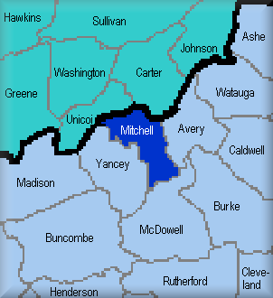
Mitchell county was formed in 1861 from parts of Burke, Caldwell, McDowell, Watauga, and Yancey Counties. The county was named after Dr. Elisha Mitchell, a professor at the University of North Carolina, Chapel Hill who was the first scientist to prove that a peak in this region of the Black Mountains was the highest point [6,684 feet] east of the Mississippi River. In 1857, he fell to his death at a waterfall while collecting data to verify his studies. In his honor, the county, waterfall and mountain were named Mitchell.
The creation of the county was triggered by the civil war and the issue of secession from the Union. The inhabitants of the southern part supported secession, while the northern residents agreed to stay with the Union. Jacob W. Bowman, Esq. [1831-1905] represented Yancey Co. to the NC Legislature and played a key role in the creation of the new county.
The mountainous county is 222 sq. miles and divided into 10 townships with Bakersville [est. 1868] as the county seat. The areas include:
|
About Mitchell Co.:
Records:
Research Links:
County Coordinator: Feel free to email me your comments, suggestions and information.
Search this site:
|
||||||||||||
|
Avery est. 1922 out of Mitchell, Watauga & Caldwell Yancey est. 1831 out of Buncombe & Burke McDowell est. 1850 out of Burke Buncombe est. 1791 out of Burke & Rutherford Madison est. 1851 out of Yancey & Buncombe Unicoi Co., TN est. 1875 out of Wash. & Carter Co., TN
Other Neighbors: Rowan est. 1753 out of Anson Burke est. 1777 out of Rowan Ashe est. 1799 out of Anson, Rowan, Surry, Wilkes Haywood est. 1808 out of western Buncombe Washington Co., TN est. 1777 out of western NC area Greene Co., TN est. 1783 out of Washington Co., TN
|
||||||||||||||
|
Links to all NCGenWeb Counties:
IMPORTANT NOTICE TO RESEARCHERS: Information on this site begins in 1861 with the creation of Mitchell County. 1870 is the first census for this county. It's important to consider the development of NC counties to know where to search and retrieve genealogical info. See Buncombe, Burke, Caldwell, McDowell, Yancey and Watauga county records prior to 1861.
|
||||||||||||||
|
|
||||||||||||||
|
|
||||||||||||||