Yancey County, North Carolina

Genealogy  NCGenWeb Project

Updated April 17, 2023


Yancey CountyWelcome to the Yancey County NC Gen Website providing online genealogical information supplied by volunteers who are committed to sharing historical 
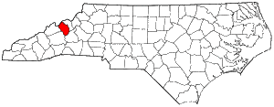
information and data.  Yancey County is located in the far western 
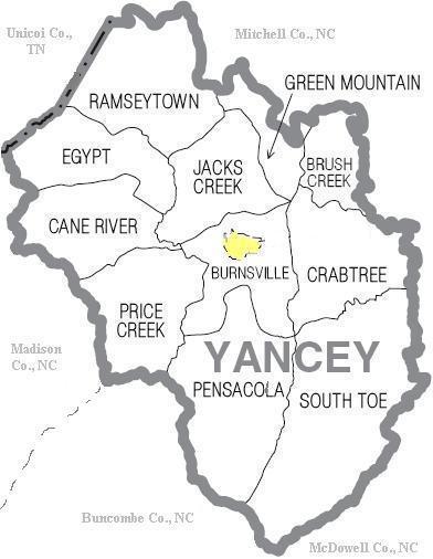
part of North Carolina which borders Tennessee.


In December 1833, Yancey County was established  from sections of Burke and Buncombe counties and named in honor of statesman Bartlett Yancey.  The county  became smaller forming Watauga [est. 1849], Madison [est. 1851], Mitchell [est. 1861], and Avery [est. 1911], counties respectively.  Since that time, the boundaries are preserved with Burnsville as the county seat, the only incorporated town and named after Privateer Captain Otway Burns [pictured below].  Bartlett Yancey and Otway Burns never lived in Yancey Co., but were prominent political leaders that influenced the development of the western North Carolina frontier.


Yancey County is a mountainous region having the highest average elevation of any county in North Carolina with 19 peaks rising over 6,300 feet.  It's surrounded by the Blue Ridge area of the Appalachian Highlands.   The Black Mountain Range crosses the south end of the county, intersected by the Blue Ridge and the Unaka Ranges.   Mt. Mitchell, part of the Black Mountain chain, is the highest peak in eastern North America with an elevation of 6,684.  It was named after Dr. Elisha Mitchell, a professor at the University at Chapel Hill who studied the area.   The South Toe and Cane rivers are the county's major waterways feeding most of the tributaries.


[Photo: Captain Otway Burns (1775-1850), after which the county seat, Burnsville, was named, was a naval hero of the War of 1812 and a politician who cast the tie breaking vote which allowed new western counties to be formed in North Carolina to include Yancey County.  There is a copper statue erected in 1909, located in the town center to commemorate him.]


History of North Carolina and its Counties    YANCEY

COUNTY FACTS AT A GLANCE:

-- Established in 1833 from Burke and Buncombe Counties

-- 311 Square Miles / 200,704 Acres

-- Mountainous region with a unique ecosystem of flora and fauna

-- County Seat:  Burnsville

-- Population in 2020:  17,712

-- Average Temp:  22-47 degrees winter / 80 degrees summer

-- Average Annual Rainfall:  44 inches; Average Annual Snow:  21 inches

-- Historical Industries:  agriculture, mining, textile, lumber, pottery

-- Historical Religions: Native American, Baptist, Presbyterian, Methodist

-- Primary Historical Ethnicity:  Native American, Irish, Scottish, German, English


Our Direct Neighbors:

Other Neighbors:

Links to all NCGen Web Counties:


IMPORTANT NOTICE TO RESEARCHERS:

Information on this site begins 1833 with the creation of Yancey Co. 

It's critical to consider the timeline of county formation to know where

to search for records and information.


FORMATION OF NORTH CAROLINA 1664 - 1965

HISTORICAL MAPS OF NORTH CAROLINA

FORMATION OF YANCEY COUNTY 1830 - 1920

EVOLUTION OF CO. TOWNS/ VILLAGES  1833 - 1970

Search

this site:


powered by FreeFind


2007-2023  All Rights Reserved.  The information contained herein is the property of individual submitters.  For information about how to become a NCGenWeb county host, please visit our volunteer page.   Yancey Co. host / webmaster is Beth Bradford Pytel.  Your comments and suggestions are always welcomed