
Return to Currituck Co.
![]()
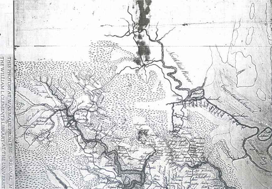
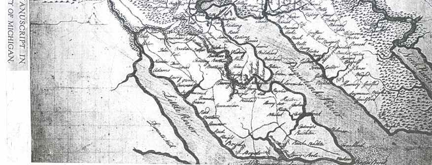
post-1770 partial Map of Currituck County (and others)
![]()
In William Doub Bennett's book Currituck County, North Carolina Eighteenth Century Tax & Militia Records. Baltimore: Clearfield Co., 1994, he describes this map as: "Unknown - post 1770 - A minute and careful survey of the land north of Albemarle Sound. The names and locations of landowners are given. May have been made during the Revolutionary War period.” By 'unknown', Bennett is referring to the map maker.
A photostatic copy of this map is housed at the North Carolina Archives in the manuscript department (Clinton Collection #293) with the notation "close to 1770, parts of modern counties of Currituck, Camden, and Pasquotank". Get a high quality image of this map from the University of Michigan.
The original map is located at the University of Michigan in the William L. Clements Library. Essentially a book collector before the Library opened in 1923, William L. Clements had acquired several notable atlases and some exceedingly rare maps bound into books relating to the period of American discovery and exploration. Shortly after the Library opened, Mr. Clements turned his attention to acquiring manuscript collections of British military and political figures active in American affairs between the 1750s and 1780s. Among his greatest acquisitions were the papers of Generals Thomas Gage and Henry Clinton, Lord Shelburne, and Lord George Germain. With each of these massive collections came hundreds of individual manuscript and printed maps of the American colonies, frontier fortifications, and battle plans from the French and Indian and Revolutionary Wars. These collections became a part of the Library's holdings with the settlement of the Clements estate in 1937.
This map (which seemed to be unfinished or a partial of a larger map) was scanned and sent to me in two sections--both huge and too large to put on one page. I've made sections of the map hoping that none of them will be too big to download on your computers. Some of the sections will overlap. The reason for making each section of the map so large is because there are many landowner's surnames (sorry, no first names) listed and in order to read them the images had to be fairly large. The main roads are seen as small dotted lines and don't seem to have changed drastically in the past 225 years. You will have to scroll across some of the pages to view different sections of the image. A few of the names may be illegible but for the most part they are fairly clear. Not all of Currituck County was on this map. Sadly, the outer banks region is totally missing. The upper right-hand side of the map deals solely with Currituck Co.; the left-hand side with Camden and Pasquotank counties. Marty Holland offers this information: "If you trace the North River all the way north to its narrowest point, everything to the east is Currituck and west is Camden. If the map was made prior to 1777, then everything west of the North River was Pasquotank. At the end of the narrowest part of the North River (where you see the names Grandy, Sawyer, Dosier, Sawyer, Bell, Sawyer, Sawyer running down the west side - see images #2 ), the dividing line continues to run in a straight northwesterly direction until it intersects with the Virginia border. So there is just a big swampy area in the northwestern part of Currituck. As far as I can tell, the names that are west of Moyock (on the northern part of the map) are all across the border in Camden. I think this is the area that is now called South Mills."
Below I've tried to piece together, as best I could, the two scans sent to me so you would have an idea of what the actual map looked like. There is also a table with links to each of the sections.
| Image #1 (77 kb) - Currituck Co. |
| Image #2 (124 kb) - parts of Currituck and Camden counties |
| Image #3 (142 kb) - mostly Camden Co. |
| Image #4 (142 kb) - Currituck & Camden Co. |
| Image #5 (143 kb) - parts of Camden and Pasquotank counties |
| Image #6 (181 kb) - Pasquotank Co. |
 |
 |
![]()