
Return to Beaufort County NCGenWeb Home Page
Return
to Beaufort County NCGenWeb Home Page
![]()
Beaufort County, NC Maps
![]()
![]() Formation of Beaufort County. N.C. (by Joyce Bell)
Formation of Beaufort County. N.C. (by Joyce Bell)
![]() 1590 White - de Bry Map of Coastal North Carolina (by Theodore DeBry)
1590 White - de Bry Map of Coastal North Carolina (by Theodore DeBry)
![]() 1630 Map of the Southeast
[Mercator]
(by Johannes Cloppenburg)
1630 Map of the Southeast
[Mercator]
(by Johannes Cloppenburg)
![]() 1696 Carte General de la Caroline (Hargrett Library, Univ. of Georgia)
1696 Carte General de la Caroline (Hargrett Library, Univ. of Georgia)
![]() 1709 Map by John Lawson (from Francis L. Hawks)
1709 Map by John Lawson (from Francis L. Hawks)
![]() 1733 A New and Correct Map of North Carolina by Edward Moseley
1733 A New and Correct Map of North Carolina by Edward Moseley
![]() 1775 A Map of North and South Carolina by Henry Mouzon (Library of Congress)
1775 A Map of North and South Carolina by Henry Mouzon (Library of Congress)
![]() c1779 Plan of the Town of Washington comprised of the original 60 lots
(online map which can be blown up to read owners names)
c1779 Plan of the Town of Washington comprised of the original 60 lots
(online map which can be blown up to read owners names)
![]() 1808 Price-Strothers Map (by John McGowan)
1808 Price-Strothers Map (by John McGowan)
![]() 1833 A New Map of the State of North Carolina (by MacRae-Brazier)
1833 A New Map of the State of North Carolina (by MacRae-Brazier)
![]() 1862 Civil War Map of North Carolina (from Harper's Weekly)
1862 Civil War Map of North Carolina (from Harper's Weekly)
![]() 1882 Kerr-Cain Map of North Carolina
1882 Kerr-Cain Map of North Carolina
![]() 1895 Map of Beaufort Co., NC (from Rand-McNally's Atlas)
1895 Map of Beaufort Co., NC (from Rand-McNally's Atlas)
![]() 2006 State Travel Map of Beaufort Co., NC (NC Dept. of Transportation)
2006 State Travel Map of Beaufort Co., NC (NC Dept. of Transportation)
![]() Beaufort Co., NC - Earth from Space
(NASA-Johnson Space Center)
Beaufort Co., NC - Earth from Space
(NASA-Johnson Space Center)
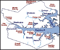
![]() Beaufort Co., NC Major Towns and Waterways (by Betsy Ross)
Beaufort Co., NC Major Towns and Waterways (by Betsy Ross)
![]() Beaufort County, NC Townships, 1930 Census (by Larry Flowers)
Beaufort County, NC Townships, 1930 Census (by Larry Flowers)
![]() Beaufort County, NC Map
(showing major towns)
Beaufort County, NC Map
(showing major towns)
![]()
|
|
© 2007-2008
McGowan/Sheppard
© 2009-present
Kay
Midgett Sheppard

