![]()
![]()
The Formation of Beaufort County, N.C.
![]()
Albemarle County
Albemarle County was formed in 1664 consisting of "all that parte of the province (of Carolina) which lyeth on the north east side or starboard side entering of the river Chowan now named by us Albemarle river together with the Islands and Isletts within tenn leagues thereof." The county was named for George Mock, Duke of Albemarle, one of the Lords Proprietors. By 1668 Albemarle County was divided into Chowan, Currituck, Pasquotank and Perquimans precincts for the purposes of local administration. Albemarle County ceased to be recognized as unit of government in 1689, although the name Albemarle County continued to be applied to the region ... well into the eighteenth century. (p. xxiii)
Bath County
Bath County was formed in 1696 from the territory south of Albemarle River. It was named in honor of John Granville, Earl of Bath. The territory was made into Archdale, Pamptecough and Wickham precincts in 1705. Bath Town was the county seat. "Whereas several Persons are seated on Pampticoe River without the Bounds of the County of Albemarle ..., it is now by the authority of this Court erected into a County & by the special direction of the Right Honorable the Governor is nominated the County of Bath." (p. 18)
Wickham Precinct
Wickham Precinct began just east of Bath at Mellyne's (later Sinclare's) Creek on the west side of the Matchapungo (later Pungo) River and on the north side of the Pamlico River including all the land from the creek eastward to Matchapungo Bluff, near present day New Holland. About 1712 the precincts of Bath County were renamed Hyde, Beaufort and Craven Precincts, respectively. Hyde was named in honor of Governor Edward Hyde.
Pamptecough Precinct
Beaufort: Beaufort was first called Pamptecough, the name being changed about 1712. It was named for Henry Somerset, Duke of Beaufort, who in 1709 became one of the Lords Proprietors. It is in the eastern section of the State and is bounded by Craven, Hyde, Martin, Pamlico, Pitt and Washington counties. The present areas is 831 square miles. Bath, incorporated in 1705, was the first county seat. Washington was made the county seat in 1785. When the name was changed no description was given. The description of Pamptecough was as follows: "lying on the north side of Pamtecought River and beginning at Molines's Creek, and westerly to the head of the river." (p. 18)
Archdale Precinct
Archdale precinct was formed in 1705 from Bath. It was named in honor
of John Archdale, governor of Carolina, 1694-1696. The name was changed
about 1712 to Craven.
"... the Precinct of Archdale taking all the south side of said (Pamptecough)
river and at present, including all the Inhabitants of Newse..." (p.
11)
Beaufort, Hyde and Craven Counties
In 1729 the act separating Beaufort and Hyde Counties authorized a courthouse to be built on the lands of William Webster, on the west side of the Pungo River for Hyde County. In 1739 the Precincts of Bath Counties were redesignated Hyde, Beaufort and Craven County.
![]()
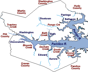
Beaufort County Boundaries
Boundary with Edgecombe and Tyrrell County
The boundary line between Edgecombe and Beaufort and between Tyrrell and Edgecombe was authorized to be established in 1741 "shall begin at the upper Corner Tree of Jenkin Henry's Line, on the South Side of the Roanoke River and from thence, run a direct line to the Mouth of Cheek's Mill Creek, on Tar River; and the said Commissioners, as soon as the said Line is finished, shall, under their Hands return the Courses, thereof into each of the Courts of the aforesaid Counties, which shall be recorded by the Clerks of these said several Courts; and the said Line so run shall for ever after, be deemed the Boundary Line between Tyrrell and Edgecombe Counties, and between Edgecombe and Beaufort Counties, from Tyrrell county as far as Tar River. And be it further Enacted, by the Authority aforesaid, That the Flat Swamp which, heretofore, was the Boundary of Albemarle and Bath Counties shall, to the Head of the said Swamp and from the Head thereof by a direct Line between Tyrrell and Edgecomb Counties, forever, be the Boundary Line between Tyrrell and Beaufort Counties."The boundary line between Tyrrell and Beaufort and between Tyrrell and Edgecombe was authorized to be continued in 1748 because taxes for surveying the same had not been collected.
"...for finishing the said Line between Part of the Edgecombe, Beaufort and Johnston Counties, already begun and Carried on to the Mouth of Cheek's Mill Creek, in Beaufort County on Tar River and from thence shall run, with a straight line to Contentnee, at the Mouth of Tosneat Swamp and thence up the main Stream of the Contentnee, opposite the Mouth of Cypress Swamp on Tar River; which said Line, when run by the Commissioners aforesaid, shall be by them entered on Record, in the Court of Edgecomb County, aforesaid, and shall hereafter be deemed and taken to be the true Bounds of the said county.... And be it further Enacted, by the Authority aforesaid, That all and every Clause and Clauses of the act, instituted, An Act for ascertaining the boundary line between Tyrrell County and Beaufort County and between Edgecombe County, Tyrrell County and Beaufort County so far as relates to running the Boundary Line between Edgecombe County and Beauforf County is and are hereby repealed and made void as if the same had never been made." (p. 18-19)
To Craven County
Part of Beaufort County was annexed to Craven in 1757 (p 19) "That the part of the said County of Beaufort, lying between Bay River and lower Broad Creek as aforesaid be from henceforth deemed, held, and taken to be part of Craven County." (p. 19)
To Pitt County
Pitt was formed in 1760 from Beaufort. The act was to become effective January 1, 1761 "That from and after the First Day of January next, the upper Part of the said County of Beaufort, beginning at the Line between the said County and Tyrrell, running South Southwest to Cherry's Run, where the main Road crosses the said Run; thence down the said Run to Tranter's Creek; thence down the said Creek to Pamlico River; thence down the said River to the Fork Point on the South side of the said River; thence up the Chocowinity Bay and Creek to the Head thereof; thence South, Southwest to the dividing Line of the said County and Craven; thence along the dividing Lines of Craven, Dobbs. Edgecombe and Tyrrell; so that all that Part of Beaufort County to the Westward of Cherry Run, Chocowinity Bay and Creek, shall, and is hereby declared to be a separate County and Parish and shall be called and known by the name of Pitt County and St Michael's Parish."
From Pitt County
Part of Pitt was annexed to Beaufort in 1785 "all that part of the county of Pitt included in the following bounds beginning at Craven county line where it crosses Creeping Swamp and running with Creeping Swamp and Checod Swamp to the mouth of Round Island branch, then a direct course to the mouth of Pitch Hole branch, then with the swamp to Bear creek, then down Bear creek to Tar River, then down the river on the north side to the mouth of Tranter's, then up said Creek to Martin county line, then with Martin, Beaufort and Craven lines to the beginning be and the same is hereby annexed to and shall be and remain a part of the county of Beaufort."
Boundary with Martin County
An act was passed in 1801 locating the boundary line between Beaufort and Martin, because disputes had arisen concerning titles to land and because of the uncertainty of the location of the boundary line. Reference was made to the law establishing Martin, but no description of the line was given in the law.
To Pitt County
Part of Beaufort was annexed to Craven in 1801 "all that part of Beaufort county that lies within the following bounds, viz. Beginning at the head of Jones' Bay, and running a direct line to Bay River Bridge, near Palmer's cabins; thence down the meanders of said Bay River to Jone's Bay, thence with said bay to the beginning." In 1811 the boundary line between Beaufort and Washington was authorized to be established and a record made in each county. No description is given in the law. (p. 20)
To Martin County
Part of Beaufort was annexed to Martin in 1816 "Beginning where the line that now divides the said counties intersects the Bear Grass Swamp, running along the main drain of said swamp, to the main drain of Tranter's Creek, thence up the main drain of said creek to mouth of the Flat Swamp, the present dividing line between the counties of Martin and Pitt"
From Hyde County
Part of Hyde was annexed to Beaufort in 1819 "That all the part of the county of Hyde, which lies upon the west side of Pungo river, be, and it its hereby added to, and made a part of the county of Beaufort"
Boundary with Washington County
An act to establish the boundary line between the counties of Washington
and Beaufort was passed in 1832.
"to run the boundary line between said counties, leading from Long
Acre to the Pungo settlement, or such parties of boundary as is yet undetermined
between said counties."
In 1851 an act was passed which stated that as the dividing line between
Washington and Beaufort had not heretofore been sufficiently described,
either by actual survey or by known and fixed boundaries, it becomes expedient,
in order to prevent disputes between the inhabitants of said counties in
relation to county affairs, that the said dividing line should be more
accurately ascertained. No description was given in the act. (p. 21)
Boundary with Craven County
In 1851 an act was passed authorizing the running and marking of the boundary line between Craven and Beaufort because of the uncertainty of the location of the said line. No description was given.
The dividing line between Beaufort and Craven was authorized to be established in 1852 "the dividing line, between said counties of Beaufort and Craven shall begin at the head of Joes's River at the bridge on the road leading from Durham's Creek to Goose Creek in Craven county, thence from said Bay River N. 47 deg. 48 min. W to Flat Swamp Bridge on the road leading from Core Point to Gaskins' Ferry, thence from said Flat Swamp Bridge N. 57 deg. 29 min. W to the run of Creeping Swamp on the Pitt county line."
Formation of Pamlico County
"That a county by the name of Pamlico shall be and the same in hereby laid off and established out of portion of Craven and Beaufort counties within the following bounds, to wit: Beginning at the mouth of South Creek in the county of Beaufort at Hickory Point, running thence up South Creek to the mouth of Bailey Creek and up Bailey Creek to the head thereof, thence a west course to Durham's Creek and up Durham's Creek to the head thereof, thence a direct line to the head waters of Deep Run and with Deep Run to Upper Broad Creek, in Craven county, and with Broad Creek to Neuse river, thence with Neuse river and Pamlico Sound to the mouth of Pamlico river, and thence up Pamlico river, so as to include Indian Island, to Hickory point, at the mouth of South Creek, the beginning." (p. 22)
To Pamlico County
"That on the first Thursday in March, one thousand eight hundred and seventy-four (1874), in Goose Creek Island township, in the county of Beaufort, an election shall be under the rules and regulations for the election of members of the General Assembly, for the purpose of allowing the qualified voters of Goose Creek Island township to vote upon the annexation of said township to the county of Pamlico. That portion of Beaufort county known as Goose Creek Island shall from and after that day, become a portion of the county of Pamlico."
To Pamlico County
"Beginning at the mouth of Goose creek and runs up Pamlico river to Lee's creek, then up said creek to the Washington road, then with said road westerly to the township line, then with the township line southerly to the Craven county line, then with the Craven and Pamlico county line to the mouth of Goose Creek, be said the same is hereby annexed to and shall form a part of Pamlico county. This shall have no effect until a majority of the qualified voters of the territory shall have declared themselves in favor of the annexation." (1876)
To Pamlico County
Part of Beaufort was annexed to Pamlico County in 1891 "beginning at the mouth of Durham's creek and running up the creek to its head, thence south to the dividing line between Beaufort and Pamlico counties, with said dividing line to Goose creek, thence down Goose creek to Pamlico river, thence up said river to the mouth of Durham's creek the beginning, be and is hereby annexed to the county of Pamlico. This act shall not go into effect until it shall have been submitted to and ratified by the qualified voters residing in the territory annexed." The election was to be held the first Thursday in May 1891. ( p. 22)
Boundary with Washington County
The dividing line between Beaufort and Washington was authorized
to be settled and fixed in 1911
"That the board of county commissioners of the counties of Washington
and Beaufort shall appoint two commissioners, one on the part of that count
of Washington and one on the part of the county of Beaufort, who shall
settle, determine, run and mark the dividing line between said counties,
from the western to the eastern terminus thereof.'
![]()
Compiled by Joyce A. Bell - Map by Elizabeth Ross
Source: The Formation of the North Carolina Counties 1663-1943, by David Leroy Corbitt, 1975
![]()
Copyright 2006
![]()