Burke County A comprehensive history of land |
 |
The following is a verbatim copy of a paper prepared by Dr. Emmett R. White in 1983. It is being included here as as a preface to the listing of the 6,000+ land grants which are currently being indexed from the existing card files in the North Carolina Room of the Burke County Library. I would like to personally thank Ms. Gale Benfield and all the wonderful Burke folks involved for making this all possible.
GO TO ALPHABETICAL LISTING - GO TO MAP
BURKE COUNTY LAND RECORDS
The following paper was prepared for the newly formed Burke County Genealogical Society and for use in the North Carolina Room of the Burke County Public Library in Morganton, North Carolina.
It is especially intended for those who are researching Burke County records, and who are not altogether familiar with the Land Records of Burke County. This should be of particular interest to amateur genealogists and historians.
EMMETT R. WHITE, M. D.
APRIL, 1983
Prior to 1729, North Carolina land transactions were handled through the auspices of the eight Lords Proprietors and their heirs. The Proprietary form of government went out of existence in 1729 when the heirs of seven of the eight proprietors decided to sell their land rights back to the Crown. The exceptions were the heirs of George Carteret, Lord Granville. Only until 1744 was his proportionate one-eighth share decided. A line was to be drawn coinciding with parallel 35º 34". All land between this parallel and the North Carolina-Virginia line would be under the jurisdiction of Granville. This slice of the pie was more than generous as it included half of the province of North Carolina.
In 1744 the Granville line was surveyed from the ocean to a point near the town of Bath. In 1746 it was extended westward to Rocky River, near present day southeast corner of Iredell County. In 1768 it was probable that is was partially surveyed west of the Catawba in order to establish a northern boundary of the newly created Tryon County; however, Tryon County did not become altogether functional until 1774 because of the indeterminate status of its southern boundary. In 1774, Granville's line was extended to the Blue Ridge.
For all practical purposes, there were no land acquisitions in Burke County prior to 1750, and certainly no settlement. A few Granville grants were issued just prior to the French and Indian War and few afterwards,--probably not more than a dozen or so.
On the death of Lord Granville, the Granville land office was closed in 1763. The heirs could not get their act together enough to reopen the office.
The advent of the American Revolution in 1775 sealed its fate altogether. The Granville District died a natural death in the courts in 1817.
Just a mention of Crown Grants -- even though Burke County should have been wholly within Granville's District, the western part of Granville's District was indeterminate. Because of this, it is possible that some of the Crown Grants may have extended into that portion of the state which now constitutes Burke County. Phifer, the Burke historian, felt that some Crown Grants extended into Burke County. The author, thus far, in a limited assay, is unable to corroborate this.
North Carolina, along with the rest of the colonies, declared its independence from Great Britain in 1776. Later that same year, the new State Constitution was drawn up. In April of 1777, Rowan County was divided and Burke County was therefore born. In the November session of the assembly of 1777, the North Carolina Land Offices were established, to begin operation in early 1778.
The newly established Land Offices recognized prior grants, i.e., Crown Grants, Proprietary Grants, and Granville Grants.
In addition, those persons who had settled on the land without due title were entitled to register their land through the grant system. In other words, squatters were allowed to register their land as much as someone who had obtained a previous grant.
Needless to say, many of those persons who had established their homesites in Burke County used this method to secure their lands. This was a relief from the previous confusion existing in the Granville land system.
In becoming acquainted with the land situation in early Rowan and Burke Counties, it is absolutely essential to understand the Land Grant Process. Land Grants were issued, insofar as Burke County is concerned, by three authorities -- The Crown (rarely, if at all), Granville's Office (a few), and by the State of North Carolina, beginning in 1778 (numerous). It is estimated that between 1778 and 1959, approximately 6,000 land grants were issued in Burke County. Of these, nearly half were issued between 1778 and 1800.
Each authority would establish its Land Office, manned by appropriate agents. The agents would be the initiating authority, would supervise the paper work, and, of course, collect fees and rents. The main purpose of the land grant system was to promote settlement, cultivation, and industry -- its secondary purpose was to make money (this often ended up being the primary purpose).
What were the steps necessary for the prospective settler to take in order to secure a land grant? First of all, he would understand that only a certain amount of land could be granted to him (usually in the neighborhood of 640 acres -- a square mile). There were criteria by which some additional amount of land could be procured. It was also understood that he must either settle on the land and/or make improvements on the land. "Improvements" generally meant a building of some sort -- such as a house, barn, sawmill, etc.
After picking out a section of unclaimed, or vacant, land he would mark the section. This was usually done by marking prominent trees, boulders, etc., or driving stakes at certain corners. The future settler then went to the Entry Officer of Claims, or Entry Taker. The Entry Taker kept an Entry Book (as it was in the state records), logged numerically. The Entry Taker, in conjunction with the future settler, would enter a brief description of the land in the entry book, describe roughly the terrain, water courses, roads, etc. If the settler was already living on the land, it would be so stated. A rough estimate of the acreage would be given. After the Entry Taker had received the entry, numbered it and had collected his fees, he would then issue a Surveyor's Warrant.
The warrant constituted the authority for the Surveyor to go ahead with his survey of the land. The entry number determined the order of the surveys. The warrant, most of the time, repeated the entry description, but would occasionally contain small bits of additional information, of value to the historian.
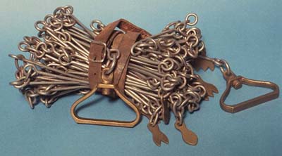
The Surveyor would survey the land, draw up a plat, and give a Surveyor's description of the land. This description would be more detailed and more technical than either the entry or warrant descriptions. The Surveyor was allotted chain carriers, appointed by the settler. These were, as a rule, relatives or neighbors. This is of value to genealogists, since these persons were listed on the Surveyor's description. [Generally, sixty-six feet in length, the chain may have weighed 12-13 pounds. While not heavy, chain bearers can generally be thought of as younger mail relatives of the settler. -DSH]
Following the survey, appropriate copies were then forwarded to the issuing authorities. After receipt of the surveys, and if there were no reasons to contest the situation, a land grant was drawn up and issued. The land grant description generally was a repeat of the Surveyor's description. The land grant gave authority to the settler to live on the land and to use the land. He could dispose of the land, in whole or in part, by the Deed method. (it must be remembered that a land grant is a primary deed)
Land grants and deeds had to be registered in county court records. The process of obtaining a land grant followed the order in Granville's Office, The Office of the Crown, and the State Land Grant Offices - namely; entry-warrant-survey-grant.
LAND RECORDS OF BURKE COUNTY
(INCLUDING ROWAN COUNTY)
AVAILABLE TO THE RESEARCHERA. Proprietary Grants - Of no interest since the area was unsettled during the proprietary period.
B. Crown Grants - As mentioned earlier, there is a possibility that some of the Crown Grants may have extended into present day Burke County. The Crown Grants are housed in the Land Grant Office, under the auspices of the Office of Secretary of State, Raleigh. The grants are housed in patent books. A file index is available. The researcher is referred to the recent publication by Mrs. Margaret M. Hofmann entitled, Colony of North Carolina Abstracts of Land Patents. This work abstracts the Crown Patents of North Carolina for a period extending from 1735-1764.
C. Granville Grants - The Granville Grants are housed both within the Department of Archives and History and the Office of Land Grants in Raleigh. A file index is available and copies can be made. Again, the researcher is referred to an upcoming additional work by Mrs. Hoffman entitled Granville Grant Patents of North Carolina. This will abstract the Granville Grants extending from the date of the first survey in 1744 through 1763.
D. Rowan County Deed Records - Rowan deeds (originals) are housed in the Court House Complex, Salisbury. Microfilm copies are available in the search room in the Department of Archives and History in Raleigh. Additional microfilm copies are available in regional libraries including The Burke County Library in Morganton. Abstracting of Rowan deeds has been carried out by Mrs. Jo White Linn of Salisbury. Two soft back editions are available listing abstract of Rowan deeds extending from the formation of the county in 1753 until 1774. For those deed records relating to Burke County between 1774 and 1777, one must go either to the original deed records in Salisbury or to the microfilm copies.
E. North Carolina Land Grant Records - The land grant records relating to the State of North Carolina Land Grant Offices are housed in the Land Grant Office of the Secretary of State, Raleigh, Mrs. Martha Paskewich, curator. A triple entry file index is used. It is listed first by surname initial and then by county and then by surname, all alphabetically arranged. The land grant records are arranged in two major sections as follows:
1. File Data - Included in this area are file envelopes, housing the information needed in preparation--of the grants. Important summary information is given on the front of each file envelope (entry dates and numbers, date of issue, book and page number of grants, and short descriptions of the land). Information contained within the envelopes generally include the following: (a) entry description (b) surveyors warrant (c) surveyors plat and description.
2. Land Grants - Housed in large books. To locate a grant it is necessary to know the book number and page number, given in the index or on the front of the file envelope. The Land Grant, as a rule, repeats verbatim the surveyors description.
*In 1977, the Bicentennial Committee of Burke County sponsored a project in which the important file data listed above was duplicated (from 1778 through 1800). The project was jointly sponsored by the Burke County Commissioners and by the Burke County Historical Society. Nathan Johnson, a Raleigh native and then a student at Brown University, performed the laborious dry copying (approximately 3,000 envelopes - nearly 10-15 thousand individual sheets). The project was supervised directly by Dr. White who made periodic trips to Raleigh to oversee the operation. The entire program was under the jurisdiction of Miss Eunice Ervin, Chairman of the Burke County Bicentennial Committee. Burke County thus became the first county in the state to duplicate these most important records (and still the only one). Security microfilm copies were made of the file data. These microfilm copies are available also in the Burke County Library. It must be emphasized that the file records in Raleigh represent the original data and no duplicated copies are available (except those in Burke County). Security microfilm copies of the grants have been made, however. When in Raleigh, dry copies can be-obtained of the file data and grants. Copying must be supervised by Land Grant Office personnel, since the original is very fragile.
F. Land Entry Books - Housed in the Department of Archives and History, Raleigh. Copies of the entry data is on microfilm and is available in the Department of Archives and History as well as regional libraries including Burke County Library.
G. Land Entry Abstracts 1778-1790- Published in two soft back editions by Mrs. Edith Huggins of Raleigh. Copies in Burke County Library. Volume II contains important supplementary information, mainly from court records.
H. Burke County Court Records - Deeds and grants were required to be registered in County Court Records. Burke County records began in 1791, prior records being lost. Court records indicated the date, grantor, grantee, and the number of acres. Land description generally was not given. Original court records are in Raleigh, Department of Archives and History Microfilm copies available in regional libraries, including Burke County Library. It must be remembered that Tax Records also list acreage and value.
I. Burke County Deeds - The Burke County Deed Records were lost during the closing days of the Civil War (Phifer says "burned or otherwise destroyed"). A few extant deeds are available, some in the hands of amateur genealogists. Burke deeds from 1865 are filed in the Register of Deeds Office, Court House, Morganton. Grantor and grantee indexes are present. The more recent deeds are also on microfilm with rapid search viewing equipment being available. Laura Anderson, currently (2015) the Register of Deeds.
Deeds can, of course, be of great value to the genealogist and historian. Many list the next of kin, usually the spouse. McBride states that perhaps 10% may contain names of additional relatives.
Miscellaneous Land Records
As mentioned earlier, land transactions and records can be found in Court Records and on Tax Lists. Additional sources include Probate Records (Wills, Inventories of Estates, etc.), Private Collections (e.g. Southern Historical Collection, Chapel Hill; McCubbins Collections, Salisbury), and Local Sources and Collections (such as those housed in the North Carolina Room of the Burke County Library).
VIRGINIA HEADRIGHTS
Earlier, in Virginia, headrights were established and defined.
In order to encourage immigration into the colony, the Virginia Company, meeting in a Quarter Court held on 18 November 1618, passed a body of laws called Orders and Constitutions which came to be considered "the Great Charter of privileges, orders and laws" of the colony. Among these laws was a provision that any person who settled in Virginia or paid for the transportation expenses of another person who settled in Virginia should be entitled to receive fifty acres of land for each immigrant. The right to receive fifty acres per person, or per head, was called a headright. The practice was continued under the royal government of Virginia after the dissolution of the Virginia Company, and the Privy Council ordered on 22 July 1634 that patents for headrights be issued.
Although seldom used during the eighteenth century, the procedure remained in effect until the passage of an act in the session begun in May 1779 which, in adjusting and settling titles to lands, gave a period of twelve months from the end of the legislative session for such rights to be claimed or be considered forfeited. A person who was entitled to a headright usually obtained a certificate of entitlement from a county court and then took the certificate to the office of the secretary of the colony, who issued the headright, or right to patent fifty acre of land. The holder of the headright then had the county surveyor make a survey of the land and then took the survey and the headright back to the capital to obtain a patent for the tract of land. When the patent was issued, the names of the immigrants, or headrights, were often included in the text of the document.
As valuable properties, headrights could be bought and sold. The person who obtained a patent to a tract of land under a headright might not have been the person who immigrated or who paid for the immigration of another person. Headrights were not always claimed immediately after immigration, either; there are instances in which several years elapsed between a person's entry into Virginia and the acquisition of a headright and sometimes even longer between then and the patenting of a tract of land.
The headright system was subject to a wide variety of abuses from outright fraud to multiple claims by a merchant and a ship's captain to a headright for the same immigrant passenger. Some prominent merchants and colonial officials received headrights for themselves each time they returned to Virginia from abroad. As a result of the abuses and of the transferable nature of the headrights, the system, which may have been intended initially to promote settlement and ownership of small plots of land by numerous immigrants, resulted in the accumulation of large tracts of land by a small number of merchants, shippers, and early land speculators.
The presence of a name as a headright in a land patent, then, establishes that a person of a certain name had entered Virginia prior to the date of the patent; but it does not prove when the person immigrated or who was initially entitled to the headright.
For extended analyses of Virginia land policies, see Fairfax Harrison Virginia Land Grants (New York, 1925, Richmond, 1979); Robert A. Stewart's introduction in volume one of Nell M. Nugent's Cavaliers and Pioneers (Richmond, 1934); Daphne Gentry's introduction in volume four of Dennis Hudgins' Cavaliers and Pioneers (Richmond, 1995); and the introduction to the Virginia Land Office Inventory, first published by the Library of Virginia in 1973.
----------
An online
series on Research in Virginia Documents. Prepared by Daphne
Gentry,
Publications and Education Services Division, The Library of
Virginia,
Copyright by The Library of Virginia; 2002
REFERENCES
- Ashe, Samuel A., History of North Carolina. (Greensboro 1925) Vol. I, p. 267.
- Clark, Walter, ed. State Records of N. C.
- Ervin, Eunice W., Morganton, N. C. re: Bicentennial Projects and Burke County Historical Society.
- Hofmann, Margaret M., Colony, of North Carolina: Abstracts of Land Patents, 1735-1764. Vol. I, (Weldon, N.C. 1982)
- Huggins, Edith W., Burke County, N. C. Land Records. 1778 (Hillsborough 1977) Vol. I. Burke County, N. C. Land Records (1779-1790) and Independent Miscellaneous Records (1777-1790) (Hillsborough 1981) -Vol. II.
- Land Grant Office; Office of the Secretary of State, Raleigh. Honorable Thad Eure, Secretary of State; Martha Pashewich, Curator.
- Leary, Helen F.M. and Stirewalt, Maurice. North Carolina Research; Genealogy and Local History, (Raleigh, 1980) p. 299-315.
Linn, Jo White Rowan County North Carolina Deed Abstracts, Vol. I and II (1753-1762; 1762-1772) (Salisbury, 1972).
McBride, Ransom, N. C. Genealogical Society Journal. Vol. IX, No. 2, May 1983, p. 68.
Oxford, Scott, Burke County Library System; Data relating to N. C. Room, microfilm, research, Land Grant File Data.
Phifer, E W. Jr., Burke, 1977 edition, p. 4-5; 327.
Phifer, E. W. Jr., Personal Communication (v.o.) to author.
Smith, Jim re: Burke County Genealogical Society Data.
Revolutionary Veterans Receive Land Grants
In 1782 each soldier and officer of the Continental line, then in service and who continued to the end of the war; or who had been disabled in the service, and subsequently all who had served two years honorably and had not re-enlisted or had been dropped on reducing the forces, were given lands as follows:
Privates 640 acres each; Non-commissioned officers lO00 acres each; Subalters 2560 acres each; Captains 3840 acres each; Majors 4800 each; Colonels 7200 each; Brigadiers 12000 each; Chaplains 17200 each; Surgeons 4800 each, and Surgeons Mates 2500 each. Immediately after the formation of Buncombe county, the rush began, and large grants were issued to Waightstill Avery. The Flowery Garden tract on Pigeon [River] was regarded as of the finest quality of land, and was granted to one of the McDowells... About 1785 Hon. Waightstill Avery of Burke took out "hundreds of grants", generally for 640 acre tracts, covering almost the entire valley of North Toe river, from its source to some where below Towcane, there being, here and there, along the valley, some older grant wedged in between his tracts. He took out grants also for lands on most all of the tributaries of the North Toe, including the lower part of Squirrel creek, of Roaring creek, of Henson's creek and of Three-Mile creek and also along the lower valley of South Toe and of Linville river, down to the Falls, and the upper valley of Pigeon in Haywood county and of Mills river in Henderson and Transylvania ....
The Swannanoa was recognized as the dividing line between Burke and Rutherford counties, from portions of which counties Buncombe was subsequently formed, and named for Edward Buncombe, who had been a colonel in the Revolutionary War. In 1791 David Vance and William Davidson, the former representing Burke and the latter Rutherford, agreed upon the formation of a new county from portions of both these counties west of the Blue Ridge, its western boundary to be the Tennessee line.
[see North Carolina Land Grants in Tennessee 1778-1791]
ARCHIVES WORKSHOP FOR BEGINNING GENEALOGISTS
Land Grant Records
1. A Land grant is a transfer of ownership of land from a sovereign power to a private citizen.
2. Land grants or patents were of two kinds:
Purchase Patents in which case the patentee bought the land outright.
Headright Patents where a settler obtained a given quantity of land simply by moving into the colony or paying for the importation of other settlers in the colony
3. The steps in obtaining a land grant:
Entry: the first application on the part of the settler that a certain piece of land be granted to him. This application originally was made to the secretary of the colony, later to a county official known as an entry-taker.
Warrant: the legal authorization to the county surveyor to go out and survey the land described in the entry.
Survey and Plat: a plat is a small map of the land to be granted drawn by the surveyor after he has survey the land, When the plat was drawn and a description of the metes and bounds of the land written on the back by the surveyor, copies of it and the original warrant were returned to the secretary of state.
Patent and Grant Issued: Upon receipt of the plat of survey, the secretary drew up a large legal form called a grant of patent and attached a copy of the plat to it. The governor then signed the grant and the secretary fixed the seal on it. The grant was then copied into one of the land grant books. When all the fees had been paid, the grant was delivered to the new owner.
4. Proprietary Land Grants (prior to 1729)
In 1663 and 1665 Charles II granted to eight men who helped him regain the English throne, an enormous expanse of land in America in which was located present-day North Carolina. Under the two charters, these eight Lords Proprietors received the authority to grant land. These grants from 1663 to 1729 were almost always in the form of headrights.
5. Crown Grants (1729-1752)
The British Crown bought Carolina back from the Proprietors in 1729. From 1729 until 1744, Crown grants were issued for land in any place in the colony. From 1744 to 1775, the royal authorities issued grants for lands in the southern part of North Carolina only. The Crown land office was closed in 1775 and there are no Crown grants after that date. The Crown continued the headright system used by the Proprietors until about 1752. After that date, purchase patents were the usual form.
6. Granville Grants (1729-1763)
At the time the Crown bought Carolina back in 1729, the descendant of one of the Lords Proprietors refused to sell his share. He was John Carteret, second Earl Of Granville. Lord Granville owned the northern part of North Carolina above a line which ran along the southern boundaries of present-day Tyrrell, Chatham, Randolph, Rowan counties from the ocean to the mountains. Lord Granville opened a land office where grants were issued from 1748-1763. Headright patents were never issued in the Granville District. Lord Granville's agents sold lands outright in the form of purchase patents to anyone with ready money. Granville died in 1763 and the land office never reopened.
7. State Grants
The state of North Carolina assumed title to all vacant lands in the state during the Revolutionary War. Land offices were opened in every county, both in the old Crown District and in the Granville District. The state granted purchase patents outright to anyone having ready money. The state of North Carolina ceased granting land in 1959.
8. Tennessee Grants
What is now the state of Tennessee was a part of North Carolina until 1790. This state made grants there from 1778 to 1790 just as it did in any other part of North Carolina.
9. Military Grants
In order to recruit soldiers for the regular army during the Revolutionary War, North Carolina promised free land in what is now Tennessee to anyone who would sign up. Militia soldiers did not receive land, only those soldiers in the Continental Line. Military land grants are all in what was then Sumner and Davidson counties (Tennessee).
10. With the major exception of the entries, warrants, and grants of the Granville District which are housed at the North Carolina State Archives, land grant records are kept at the Secretary of State Land Grant Office, 300 N. Salisbury St., Raleigh, N.C. 27603.
NOTE: Burke County was in the Granville District but the district had indeterminate borders so some Crown grants may be in Burke County.
Speculation Lands Collection
(1752-1930)
In Philadelphia in September of 1795, two agents, Andrew Baird and Lewis Baird, approached Tench Coxe, assistant to Alexander Hamilton, Treasurer of the United States under the Jefferson administration regarding land holdings of some half million acres in western North Carolina. The Baird agents represented the interests of the Rutherford Land Company that consisted of some 18 members or Trustees, including William W. Erwin , James Greenlee, and others. The Rutherford Land Company was apparently been created by Greenlee who owned extensive tracts in Burke County, North Carolina. Andrew Baird, a former New Jersey iron master, knew members of the Coxe family and this possibly accounts for the primary interest in Coxe as an investor. The Bairds offered Coxe an opportunity to purchase some or all of the land holdings of the Company, described as "east of the Blue Ridge Mountains" for 9 cents an acre. The tracts Tench Coxe eventually purchased, however, appear to have included land in present day Rutherford County, Polk County, Henderson County, Cleveland County, McDowell County and in Buncombe County. [William W. Ervin and Andrew Baird to Coxe, Sept. 17, 1795, Coxe Papers.]
Tench Coxe through a series of purchases obtained some 400,000 acres in western North Carolina. He managed to retain many of the land holdings for some twenty years by placing his real estate into a land trust. The first trust was held by William Tilghman, a trusted cousin and family lawyer, another friend and relative Abraham Kintzing, and a close relative, Richard Coxe, his wife's brother. It is believed that Pierre-Estienne DuPonceau, a family friend and lawyer was also appointed a trustee at this time. A more detailed description may be found at: http://toto.lib.unca.edu/findingaids/mss/speculation_lands/default.htm
Metes and Bounds - Units of Survey Measurements
The
use of chains to measure land (survey) was developed by
Edmund Gunter in 1620 and was based on the English statute for
measuring which was set in law that one "pole" equaled
one "rod"
- either term equaled 66 feet.
Edmund Gunters chain was developed to make surveying
easier.
It consisted of 100 links which totaled 4 "poles,"
which equals 66 feet.
1 link of chain = 7.92 inches (.66 feet)
25 links of chain (1/4 of total) =
1 perch = 1 pole = 1 rod = 16.5 ft.100 links = 1 chain = 4 poles or rods
1 chain = 66 feet
10 chains = 1 furlong = 660 feet = 40 poles
80 chains = 1 mile
1 square chain = 16 square poles
160 square poles = 1 acre
Ref:
[1] Steve Broyles' DeedMapper page
[2] Practical Surveying for Technicians by Robert P. Landon;
[3] The North Carolina Genealogical Society Journal, Volume XVI, No. 2, May, 1990: page 83, by James W. Miller, Jr., of Hickory, NC
Many thanks to Melissa Grider and Charmaine for their added help.
ISSUED LAND
GRANTS
References to update: 8 January 2004 - 13 Mar 2004
LAND GRANT BY NAME |
LAND GRANT BY YEAR |
NEED
A COPY? See the BCPLS Policy regarding
Land Grant copies, as
well as other genealogical help.
UNISSUED LAND GRANTS
These are the Burke
County Land Grants issued from 1779 to about 1803
(The land office was not issuing grants when the county was
formed, in 1777).
Note that this includes Granville Grants (1750-1768)
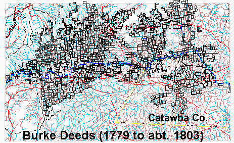
[Created by DeedMapper Ver. 3.0:20 (c) 2000 Directline Software]

© 2016-present By accessing this site, you hereby agree that any data posted is copyrighted by the NCGenWeb, the respective county host and/or individual contributors. Nothing contained herein is to be used for other than personal research and is not to be reposted, captured or cached on another server without the express written consent of the contributor.

Robin Mace Barger - © 2016-present
Last Modified: