![]()
![]()
THE ARCHAEOLOGY OF
COLINGTON ISLAND
![]()
SETTLEMENT AND SUBSISTENCE
ON
COLINGTON ISLAND: A SUMMARY
One of the most striking characteristics of the sites on Colington Island is the similarity of locational factors, regardless of the age of the sites. Each site is on the immediate shoreline, oriented directly toward a bay or smaller expanse of open, relatively shallow water; each lies on a ridge of Fripp fine sand, the typical soil of forested and stabilized dunes; and each has a number of microenvironments within easy access. The sites also share similar intrasite and primary subsistence patterns indicative of a single site type, although the cultural and intersite systems to which they belonged varied through time.
LOCATIONAL FACTORS
The location, topography, soils, plant and animal communities of Colington Island offer a limited choice, now and in the past, for human subsistence, settlement and other activities. It is not by accident that the more stable communities of the modern period occupy locations on, or similar to, the prehistoric sites.
All communities, past and present, on Colington Island are located on the shore, emphasizing their orientation to maritime transport, communication, subsistence, and in modern times, commerce. Along the shore, all communities occupy the high, forested dunes of Fripp fine sand, although some sections of modern communities have spread onto the gently sloping sands adjacent to or between the higher dunes, and onto "made land" which now fills former marshes and other low areas. The high, forested dunes offer excessive drainage, thus relatively dry conditions for habitation, and protection from storms by virtue of the well developed canopy forest and its understory. The Fripp fine sand of the high dunes has a canopy forest of live oak, loblolly pine, American beech and hickory with an understory of dogwood, American holly, black cherry and yaupon holly. The ground cover includes muscadine grapes, cabbage palmetto and other species (U. S. Department of Agriculture 1977: 46).
On these shoreside dunes, all of the known prehistoric sites are found: 31DR12 on Little Colington is oriented toward Dog Point Creek, a small aim of Blount Bay; 31DR13 in the community of Eagleton parallels the west shore of Blount Bay; 31DR14, 33 and 34 lie along the north shore of Big Colington on Kitty Hawk Bay; and 31DR15 and 16 along Albemarle Sound on the northwest shore. In each case the habitation lies on the higher elevations of the forested shoreside dunes, between 10 to 50 feet (3 to 15 meters) above current sea level (or well above sea level at the time of original occupation). In close proximity to each site there is the (Page 47) marine environment of the bays, lower slopes with different forest communities, the low, wet flats around fresh water marshes and ponds, and the ponds and marshes themselves. The primary reasons for selection of the site locations probably were (1) elevation, (2) proximity to the bays and their food resources, particularly the oyster beds, and (3) protection from storms offered by the forest cover. Evidence of minor exploitation of the other microenvironments exists in all the sites, but was certainly secondary to dependence on the aquatic environment.
THE TEMPORAL DIMENSION
At least within the time continuum represented by the sites on Colington Island, the environment of the island has remained relatively constant until the very recent period. Forests have been destroyed by storms or cut for timber and have replaced themselves in normal succession, dunes have buried older land surfaces in their southward and westward march, ponds and marshes have been filled and others created, and shorelines have gradually eroded or extended in response to sea level rise, storms and sedimentary deposition. With the exception of 31DR12 and 13, both of which were too disturbed for such observations, all the sites were deposited on older, buried land surfaces, the forest floor humus capping the Fripp fine sand dunes at the time of initial occupation at each site. The gray humus of Zone IV in sites 31DR14, 33, 34, and 15 was that land surface, and in each site there was evidence of tree roots of the former forests extending downward from that zone. Certainly, not all of the older land surface was exposed throughout the temporal span of the sites, and there is ample evidence of a continuous process of dune shifting and building in all of the excavated sites.
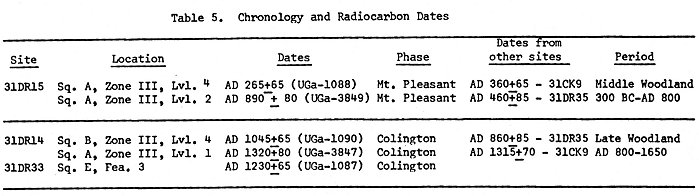
The earliest evidence of human occupation on the island occurs during the Mount Pleasant phase, in the first few centuries A.D. The radiocarbon date of A.D. 265 + 65 from the lowest level of 31DR15 probably falls near the initial occupation of that site, and may indicate the period of initial use of the others. 31DR15, Rush Point, and 31DR16, Stick, are pure Mount Pleasant sites, and the presence of Mount Pleasant ceramics mixed with the later component in sites 31DR12, 13, 14, and 33 argues for at least some use of these during that phase. The main Mount Pleasant occupation areas of 31DR14 and 31DR33 had been lost to erosional processes long before this research began. A radiocarbon date of A.D. 890 + 80 for the upper midden at 31DR15 falls near the temporal boundary between the Middle and Late Woodland periods (Table 5), and seems too late for the depositional sequence at Rush Point. Modern contamination is the apparent explanation for this error, but the date does agree with the end of the Mount Pleasant phase.
Beginning around 800 A.D., the Colington phase is the prehistoric culture of the Algonkian people who inhabited the coastal zone in protohistoric and early historic times. Major Colington (Page 48) components were found at 31DR13, Eagleton, 31DR14, Kitty Hawk Bay, and 31DR33, White Court, all indicative of a preference for the north shore of Big Colington during this phase. 31DR34, Colleton Lane is a small, but disturbed Colington phase site probably related to 31DR14, and the data from 31DR12, Beaseley, and 31DR15, Rush Point, imply only sporadic, perhaps transient use during this phase. Two radiocarbon dates from 31DR14, A.D. 1045 + 65 and A.D. 1320 + 80, derived from the lowest and upper levels of the midden deposits, respectively, imply at least a 300-year-long use of the site. A date of A.D. 1230 + 65 from 31DR33 reinforces the general contem- poraneity of the two sites suggested by their similar artifact assemblages.
The temporal span of the Colington Island sites begins near the mid-point of the Middle Woodland, ca. 250 A.D., and continues until around 1400 A.D. in the Late Woodland period. The radiocarbon dates (Table 5) do not necessarily bracket the site sequences, but do serve as indicators of temporal span at 31DR14 and 15, and provide at least one date within the sequence of 31DR33. The dates derived from Rush Point (31DR15) compare favorably with those obtained from the Mount Pleasant phase components of other sites. These are A.D. 360 + 65 from the Baum site (31CK9) in Currituck County (phelps 1977b: 20), and a recently received date of A.D. 460 + 85 (UGa-3435; B.P. 1490 + 85) from the Tillett site (31DR35) on Roanoke Island. Dates from the Colington phase components at Kitty Hawk Bay (31DR14) and White Court (31DR33) are comparable with those from the earliest Colington occupation at the Tillett site, A.D. 860 + 85 (UGa-3433; B.P. 1090 + 85), and the Baum site, A.D. 1315 + 70 (phelps 1980b).
INTRASITE PATTERN
The internal structure and spatial relationship within the Colington Island sites is as standard as the site locational factors, and this similarity in intrasite pattern, like the locational factors, existed throughout the temporal sequence.
The pattern is simplistic; scattered in random, lens-shaped piles on the crests and shoreward flanks of high dunes are oyster shells, other food remains, a few ceramic sherds, artifacts, charcoal and ash. Between these piles of midden debris the older humus is nearly devoid of artifacts, features, or structural evidence, although the absence of such data may be related to the relatively limited excavated areas. Hypothetically, each small midden deposit should have a shelter and activity areas in relatively close association. It is quite possible that some type of temporary shelter was built and used. Only those dune ridges in immediate proximity to the shoreline of the bays were selected as sites, reinforcing the emphasis on marine adaptation.
Within the shell middens, which are obvious refuse heaps, artifacts and other debris are randomly scattered. The few features encountered were either fire pits (hearths) or cooking (Page 49) pits; others were refilled and their function could not be determined.
![]()
(Page 50) |
![]()
The major portion of the cultural data recovered in these dispersed middens is directly referable to subsistence activities of food procurement, preparation, and discard after consumption. There is no direct evidence of food preservation for future consumption. The one activity other than food procurement present in all the sites is food preparation, cooking and temporary storage, based on the fire areas, cooking pits and the few ceramic sherds representative of a small number of vessels, probably brought with the inhabitants rather than produced on the island. Activities present in only the Colington phase sites are (1) processing of animal parts (antlers, hides) and tools and garments, and possibly clothing production or repair (bone awls and abrader); and (2) production of a few lithic tools, based on the small number of spalls, and, possibly, procurement of lithic resources from the ocean beaches although the raw material material may have been brought with the group.
The very low density of cultural material in the middens can be seen in the following list, which gives the average number of sherds, spalls, and faunal remains (bone count) per 10-centimeter level in a 2-meter square for each of the sites.
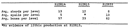 |
Compared with densities of approximately 100 to 500 or more sherds per level in comparable excavation units in known permanent villages, these counts are extremely low and reflect brief occupations and a limited number of cultural activities. This is also confirmed by the quite limited range and number of other artifact classes and types in the Colington Island sites. A less significant difference in the number of spalls and faunal remains occurs between these camps and permanent villages, but the counts for the latter site type are generally higher in these categories.
Each of the sites gives the impression of a temporary stay, sufficiently long to satisfy specific subsistence needs or preferences, by a small group of people. While no seasonality can be inferred for the Mount Pleasant phase site (31DR15), the Colington phase sites appear to have been used in the spring (31DR33) and late summer-early fall (31DR14). The group may have been one or more extended families, but their actual number and the type of social unit can only be implied from the data. That family units, (Page 51) rather than a group of one sex, occupied the sites is hypothesized from the artifact types and range of activities present in the sites and their implications for a normal division of labor. The dispersed nature of the middens also gives the impression of infrequent use over a considerable period of time. This may have resulted from a need to conserve the available oyster population, or a very small population occasionally exploiting these resources. In either case, the middens did not accumulate to the depth and extent of those associated with intensively occupied seasonal villages or permanent mainland villages where acres of shell midden grew to an appreciable height. In a sense, they represent a beginning stage of shell midden development, and were never used frequently enough to produce the overlapping, layered deposition characteristic of larger middens.
The site type is classified here as temporary camp (procurement camp; subsistence camp) with a primary function of habitation while exploiting marine food resources. Secondary subsistence activities included hunting and trapping of some fauna from the uplands, fresh water ponds, and marshes, and collection of forest products (in at least one site).
SUBSISTENCE PATTERN
The primary subsistence activity of all the Colington Island sites was shell fish collecting and consumption. Oysters were evidently the main food resource which led to establishment and continued seasonal use of the sites, and specific location and availability of oyster beds was probably a main factor in site location through time. No oysters live in the northern estuaries today because of the low salinity of the water. The closest living beds are in the vicinity of southern Roanoke Island (Porter 1974: Figure 1), 10 miles south of Colington Island. At the time the Colington Island sites were inhabited, however, and through the early years of the nineteenth century (Stick 1958: 9), there were inlets through the northern Outer Banks which provided an exchange of sea water with the flow of rivers empyting into the Albemarle Sound. Knowledge of the opening and closing of inlets through the north banks extends backward only to the 16th century, but the dynamic forces which create and close these corridors to the sea have been operable for many centuries before the first maps were produced. During the temporal span of the Colington Island sites, inlets were certainly open in close proximity to provide the salinity necessary for oysters and salt water fish species in the waters around the island.
A study of relict shell reefs for purposes of determining the extent and commercial value of the oyster shell in the estuaries reported large areas of shell between Colington and Roanoke Island (Page 52) and along the channel adjacent to the west side of Colington Island. No large beds were found in Kitty Hawk Bay, at least in the area sounded (N. C. Department of Conservation and Development 1964: 3). A more comprehensive and detailed study (Sampair 1974: Plate 3) mapped the large reef southwest of Colington Island, but did not take cores or soundings in Kitty Hawk Bay. These studies show that oysters have been available in vast quantities in the northern estuarine zone in past times, but the dates of these beds are unknown. Also, because of their emphasis on larger, commercially valuable deposits, many smaller beds were not mapped and more shallow bays were not explored.
The distribution of Mount Pleasant phase sites on Colington Island confirms existence of productive oyster beds along the western shore and in Kitty Hawk Bay and other smaller embayments between 200 and 800 A.D. The Colington phase sites along the north shore were certainly located to exploit beds in Kitty Hawk Bay, and the sites offer ample evidence of availability of oysters in that bay from 800 to 1400 A.D., and perhaps later. Haag (1958: 39) opined that the beds in Kitty Hawk Bay were evidence of an inlet to the ocean at that point, but this is argumentive. Recent geological studies have mapped relict channels and potential inlets just south of Colington (Riggs and O'Connor 1974), but no data have been obtained for Kitty Hawk Bay. Clams and miscellaneous gastropods from all sites were probably harvested along with the oysters but were insignificant as a food resource. The Venus clam shells at 31DR33 may represent intentional gathering of this species during the Colington phase, since these shells are relatively frequent in sites of this phase elsewhere.
The absence of fish remains, except for a few sharks or rays, at 31DR15 is somewhat remarkable, and indicates a coastal adaptive pattern solely oriented toward shell fish. Whether this was the result of specialized cultural preference or lack of knowledge of marine foods cannot be determined, and presents a problem to be studied at other coastal sites of the Mount Pleasant phase. Although land fauna such as deer and racoon were incidentally hunted, the reptilian resources of the freshwater ponds and marshes were ignored even though these animals were certainly known from inland areas.
On the other hand, the Colington phase sites at 31DR14 and 33 represent a thorough knowledge and efficient exploitation of the total coastal environment. Second only to shell fish, the Colington phase population relied on seasonal availability of large and small salt water fish, and on fresh water species when available during periods of sound flushing. The species represented would have required a number of fishing techniques such as hook and line, nets, weirs and other methods. Fish remains in these (Page 53) sites account for more than 90% of the total meat from non-shell fish sources. The upland forests were also exploited for deer, raccoon, rabbit, box turtles, and hickory nuts (at 31DR33) as a tertiary subsistence pursuit. The fresh water ponds and salt marshes were equally valuable, yielding turtles and alligator as well as ducks and clapper rails. The two Colington Phase sites were apparently utilized in different seasons, perhaps by the same group of people, in a pattern of maximum use of the group's territory.
THE INTERSITE PATTERN
Reconstruction of the intersite pattern, the synchronic relationship between the sites in a cultural system, to which the Colington island sites belonged may only be inferred at present. A recent cultural historical summary of coastal North Carolina (phelps 1980a) proposed basic regional and sub-regional sequences, but the past history of archaeological research in the area is too brief for specific delineation of territories utilized by single socio-political units.
The Mount Pleasant phase sites on the island are temporary camps occupied periodically for maritime subsistence activities. All of the Colington Island sites were used during this phase, indicative of the island as a popular area for oyster collecting and other supplementary, subsistence activities. The temporary camps on Colington are only one specialized part of the Mount Pleasant phase subsistence system, which is presumed to have been based primarily on agriculture. Larger permanent sites are known on the mainland, particularly on Currituck Sound and its tributaries (phelps 1980a: 41) but which of these sites are contemporaneous and systematically related to those on Colington Island cannot yet be discerned. The size of the territory exploited by one group may have been relatively large, and if the fresh water mussels from the Rush Point site are correctly interpreted, some of the occupants of that site were from the western reaches of the Albemarle Sound, or its tributaries, a distance of about 50 miles or more. The impression given by the evidence at 31DR15 is one of a culture not yet fully adapted to the coast, using only a select few of the available resources.
The basic settlement pattern of the Colington phase (phelps 1980a: 47-48) is better known than that of Mount Pleasant. The phase name, Colington, is derived from the island itself and the sites representative of this phase on the north shore. Mainland Colington phase sites are usually located where agriculture, hunting, gathering, fishing and shell fish collecting (both fresh water and marine) could be all accomplished within a relatively small catchment area. The Colington Island sites of this phase may have been supplementary subsistence camps for one of the immediate coastal socio-political units, or places where groups from the inner part of the estuarine system came to obtain marine resources. The (Page 54) almost exclusive use of Jasper as the primary lithic material in the Colington sites suggests a group familiar with coastal resources, but the availability of this material on the coast could easily have been known to more inland groups. Again, further research will be required to formulate specific territories and intemite relationships. Until then, any one of the Algonkian socio-political units in Currituck or the other counties bordering Albemarle Sound can be viewed as likely inhabitants of the Colington sites. The closest groups in the Algonkian distribution would have travelled less than two miles from their mainland villages at Point Harbor, but others were situated 80 miles or more away from the island. Whatever their origin, the seasonal occupants of the Colington phase sites on the island had a thorough knowledge of coastal resources and exploited them efficiently.
Irregardless of the particular cultural system to which the prehistoric visitors belonged, it is obvious that Colington Island has seen similar use since it was first occupied sometime in the 3rd century A.D. The island's natural limitations preclude stable or long-term agriculture, although this was attempted and abandoned, and its inaccessibility was a prohibitive factor for settlement until the technology of the 19th century. The island has seen prehistoric oysters and fishing camps, relatively permanent historic fishing comunities sustained by an elaborate redistributive and exchange system, and now is burgeoning with temporary sites again, the sunner settlements of an affluent modern society. (Page 55)
![]()
Copyright ![]() 2002
2002
Carolina Algonkian Project, All Rights Reserved
![]()