![]()
![]()
THE ARCHAEOLOGY OF
COLINGTON ISLAND
![]()
INTRODUCTION
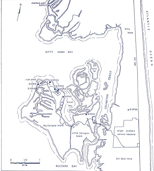
Colington Island is one of the chain of barrier islands which form the Outer Banks along the coast of North Carolina, separating the vast sounds of estuarine system from the Atlantic Ocean. It lies on the sound side of Bodie Island in Dare County, and was once a part of that island when sea level was lower than at present. Now it is separated from Bodie Island by the narrow passage of Colington Creek on the east and Kitty Hawk Bay on the north (Figure 1).
The Outer Banks are a fragile barrier constantly changing through time in response to the dynamics of nature, and their form in any synchronic segment along the time continuum is the result of a momentary balance between the dynamics of rising sea level, winds storms, tides and sedimentary processes. Although never completely stable, the Banks have maintained their current general form for approximately two to three thousand years, according to geological estimates. Archaeological studies also support that conclusion, having found no evidence of human use on the present surface of the islands prior to about 1000 B.C. and frequent use only within the past 2000 years. Colington Island is no exception to this; its initial occupation by native Americans probably occurred sometime between 200 and 300 A.D. and continued at least until the 14th century occupation by Algonkian people of the coastal region.
There is a vast difference in the appearance of the island's surface of 200 A.D. and at the present; the original inhabitants would certainly be amazed, probably appalled, by the modern appearance, and perhaps some of the modern residents would prefer to see Colington as it was eighteen centuries ago. Human culture is, however, as changeable as nature, and the island has changed in response to both nature and culture. This paper describes the earlier inhabitants of Colington Island from about 200 to 1400 A.D., adding another chapter to the continuing history of the island and the coastal area.
![]()
COLINGTON ISLAND TODAY AND IN THE PAST
From the air, Colington Island resembles a verdant butterfly with a tattered right wing, resting on the shoals inside the barrier islands (Figure 2). Its current shape is the result of rising sea level, erosion, and other natural processes which continually change the coast. Once connected with Bodie Island, it shares with that and the other barrier islands a surface topography of sand dunes separated by lower, wet areas, marshes and ponds. On the northeast side of the island the dunes trend northwest-southeast in parallel rows, on the south side they are irregularly spaced and oriented north-south, and on the northwest end of the island they follow a general east-west alignment except where they parallel the west shore of Blount Bay on the east and Albemarle Sound on the (Page 1) west. The dunes are not all of the same age, and their orientation reflects different directional forces affecting their fomation. Evidence of continuing dune migration was observed during the archaeological research, and there is no reason to doubt that it will continue.
![]()
|
Figure 1. Colington Island in coastal North Carolina. (Page 2) |
![]()
Soils on the island are either the fine sands of the dunes and their slopes or peats in the swales, marshes and ponds. Vast areas of shoreline marsh occur on the southeastern part of the island, and smaller areas are found on the northeastern and western shores. The islands directly north of Colington (Burnt Island and the Southern Islands) are also marsh, dissected by numerous shallow channels between Colington Creek and Blount Bay. A large marsh and pond embayment almost encircled by high dunes originally existed on the center of the north-western part of the island, and smaller interior marshes and ponds were located north and east of the larger one.
The dunes, presently ranging in height from 10 to 60 feet above sea level, originally supported forests of live oak, water oak,, hickory, pine, American beech, and other canopy species towering over the yaupon holly and dogwood in the understory. The forest floor supported palmetto, muscadine grapes and other plants. Gum, cypress, maple and wax myrtle on the lower slopes and flats gave way to willow, and finally marsh grasses in the peaty marshes and around ponds. The plant communities supported a varied array of fauna and the waters around the island contained numerous fish and shellfish such as oysters, clams and various gastropods.
Man has modified the island since his first occupation some 1800 years ago, but the earlier inhabitants did little more than cut trees for shelter and firewood, deposit their food refuse in heaps on the dunes, and dig a few pits for cooking and other activities. Even into the early years of this century, much of the island had not been irrevocably changed, but the past three decades have witnessed extreme modification.
The last native American inhabitants of Colington Island were people of the Algonkian-speaking culture whose territory included 6000 square miles of northeastern North Carolina from the Neuse River to the Virginia line, and from the Outer Banks to the heads of Albemarle and Pamlico sounds. Probably, there was no Algonkian settlement occupied on Colington Island at the time of the first English contact between 1584-1587 since the records of the exploratory expeditions make no reference to it, and John White's maps of that period show what is now Colington as a western bulge on Bodie Island. Colington Island emerges into the historic stream as Carlyle Island on 17th century maps, and was the first property in the Carolina Colony to be granted to an individual by the Lords Proprietors in 1663. (Page 3)
David Stick, the noted historian of the Carolina coastal area, has traced the history of the island from that time to the present (Stick 1953: 265-267; 1970). The grant of the island to Sir John Colleton resulted in a change of names from "Carlyle" to "Colleton", and the modern Colington is a derivative of the latter. Peter Carteret, one of Colleton's partners in the venture of establishing a plantation on the island, cleared land and planted corn and vineyards, and stocked the island with cattle and horses by 1655. The venture failed, presumably due to the devastating effects of a series of hurricanes, but is doubtful that extensive agriculture would have proved successful on the island soils even under ideal conditions. Some surviving correspondence of this venture provides interesting details of the endeavors and results of Colleton Plantation (Powell 1958), but no archaeological evidence of the plantation has been found.
Colonial settlement of the island began in the 1670s and by 1750 the island was divided into its two modern parts, Big Colington and Little Colington, by excavating a canal from the head of a small creek at the south end of Blount Bay southward to Buzzard Bay (Figure 2). Nineteenth century settlements were located on the south side of Big Colington, but late in the century the population shifted to the northern shores. In the late 19th and 20th centuries, the communities of Colington and Eagleton grew around the southwestern and northwestern shores, respectively, of Blount Bay. These communities supported themselves by commercial fishing until the decline of this industry (Stick 1958: 267).
Colington Island today has a mixed settlement pattern. A few permanent residents live mostly in the older communities, but seasonal cottages, house trailers, camp grounds and other tourist-related features stretch in an almost unbroken line along the paved road. The entire northwest section of Big Colington has been developed as the Colington Harbour resort community, complete with paved streets, a recreation center, and a guard gate. The lots of that development are on the high dunes and on "made land" adjacent to the canals and basins dredged from the former interior marsh. Regardless of eighteen centuries of culture change, Colington Island is still a place of primarily temporary settlement.
![]()
THE ARCHAEOLOGICAL PROJECT
Prior to 1972, only one published archaeological study existed for the entire northern coast and coastal plain of North Carolina. This was the work of William Haag (1958) who surveyed the shorelines of the Albemarle and Pamlico estuaries and parts of the Outer Banks in 1955-56 in a search for Algonkian sites which might correlate with those mentioned in the English exploratory records (Corbitt 1953). In the process, Haag recorded a number of archaeological sites and proposed a cultural-historical sequence (Page 4) which, although accurate in some respects . was in error in placing the entire sequence much too late in time. This, however, was a common error in American archaeology prior to wide availability of physical-chemical chronometric techniques such as radiocarbon dating. Haag's micro-culture areas of the "Banks" and "Sounds" have not withstood the test of time and additional data, since no major cultural distinction appears to exist within the estuarine zone. While minor differences may be seen in the material culture of socio-political units on the coast and these further inland on the Coastal Plain, the estuarine, or Tidewater, zone has a cultural-spatial integrity through time.
Since 1972, a number of archaeological studies related to environmental impact in the northern coastal area (phelps 1978) and the Colington Island vicinity (phelps 1977a; 1976), and basic archaeological research (phelps 1960b; 1977b) have provided sufficient data for the formulation of a cultural-historical model (phelps 1980a). The area surveyed by Haag is now designated as the Tidewater subregion of the North Coastal Region of North Carolina, and is approximately the area shown in the small inset map in Figure 1. Haag's "Early" and "Middle" periods were defined on the basis of a mixed assemblage, but can be generally correlated, with the Middle Woodland period Mount Pleasant phase (300 B.C. - 800 A.D.) in modern context. This applies particularly to the ceramic assemblage described by Haag, and factors out such artifacts as the Archaic period projectile points. His "Late" period, which he presumed to be almost historic, is the Colington phase (800 - 1650 A.D.) in this report, and is the prehistoric culture of the Carolina Algonkians.
In 1972, a study of the archaeology of the North Coastal region was initiated at East Carolina University. From the beginning of the archaeology program a year earlier, a research design for eastern North Carolina had been developed which drew from the known ethnohistoric data and cultural distributions a synchronic cultural-spatial framework. With this model as a guide, sites in each region or subregion could be investigated and regional sequences developed. This design applied not only to pure research, but to research as a mechanism for student training as well; for that reason, the 1972 field school in archaeology was conducted on the coast, working from a temporary base at Manteo on Roanoke Island. The goals set for 1972 were re-survey of the sites recorded by Haag on the Outer Banks and Roanoke Island in Dare County, location and recording of new sites, and test excavations where feasible in sites with potential for context.
The work on Colington Island began with a re-survey of the previously recorded sites. When the intact condition and imminent danger of destruction through development was determined for the sites within the Colington Harbour community (31DR14, 15, 16, 33, 34), permission was obtained to excavate tests in some of these. (Page 5) Approximately 12 students, under the direction of the author, worked for three weeks in late June and early July excavating and mapping sites 31DR14, 15 and 33. All specimens, photographs and data from these sites were cataloged during the field school session, and deposited in the permanent collection at East Carolina University at the termination of the session. A preliminary analysis of the ceramic specimens was accomplished in 1975-76, three radiocarbon samples from the sites were processed and dated with some extra funds available in 1975, and these data were included in a summary report (phelps 1977b). In the meantime, various funded projects took precedent over the Colington Island data and only when funds were made available through the current grant could sufficient time and personnel be budgeted for this study, including analysis of the faunal remains and additional radiocarbon sample dating (Table 5). Non-fish faunal remains were analyzed by Dr. Jeannette Runquist, Assistani Professor of Biology, Winthrop College, Rock Hill, South Carolina (see Appendix A), and fish remains were studied and reported by Dr. Camm C. Swift, Associate Curator of Ichthyology, Natural History Museum of Los Angeles County, Los Angeles, California (see Appendix B).
A comprehensive survey of Colington Island was not part of the project, but most of the dune ridges and slopes in the Colington Harbour property were inspected for archaeological sites. At least one location in the village of Colington was reported to us; in that instance, shell was observed where the slope of a dune had been cut to make room for a mobile home. No artifacts were seen with the shell, but the location on the southwestern side of Blount Bay was recorded. It is possible that some of the other shoreside dunes on the island also cover archaeological sites.
The known sites, which are the subject of this report, provide a basic understanding of culture history and land use, and some speculation on the relationship of Colington Island to the mainland in prehistoric times.
![]()
ARCHAEOLOGICAL SITES ON COLINGTON ISLAND
The seven known archaeological sites on Colington Island are located along the northern and northwestern shores of the island (Figure 2). Five of the sites were first recorded and collected by Haag (1958), who performed test excavations in only one of them. In 1972, all of these sites were re-surveyed and surface collected, two additional sites were located and recorded, and excavations were conducted in three of the sites. Other sites in the locality are 31DR39, a secondary deposition (phelps 1976) north of the Wright Brothers Memorial, and 31DR17, Shellbank Point, first recorded by Haag (1958: 36) and resurveyed by the author in 1977. This site, although disturbed by construction and erosion, has multiple components, including one of few Rangia clam middens known in this area. The latter component has been assigned site number 31DR46 (phelps 1977a:82), but the site has been so disturbed by real estate development that only limited research potential remains. (Page 6)
The Colington Island sites span approximately 1,500 years of prehistory during the Middle and Late Woodland period, and throughout their temporal span appear to have had similar functions and intrasite patterns regardless of change in other aspects of the culture of the people who occupied them. Each site is a small, specialized unit of the broader settlement pattern to which it belonged, and, as such, adds a significant dimension to knowledge of coastal cultural systems. The prehistoric sites also conform a pattern of land use and subsistence which has been relatively constant since the first occupation of the island, modified to some extent in modern times by new technology and redistributive systems.
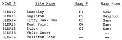
The sites are described in their locational order from the northeast point of Little Colington, to the northwestern shore of Big Colington Island. For convenience, the modern site names and North Carolina Archaeological Survey (NCAS) numbers are correlated with Haag's site numbers in the following list:
 |
![]()
BEASELEY SITE, 31DR12
The Beaseley site, the only one presently recorded on Little Colington Island, is located 1000 feet (305 meters) north of S.R. 1217 on the shore of Dog Point Creek (Figure 2). The site area is barely 2 feet (.6 meter) above present sea level on the northern end of a ridge of Fripp fine sand. This ridge has the highest general elevation on the northeastern end of the island, and is the easternmost extent of the Fripp soil. Surface morphology on this part of the island is characterized by a series of forested sandy ridges which trend northwest-southeast separated by sloughs or depressions of wet soils, the entire configuration reminiscent of dune topography now being drowned by the rise in sea level.
When Haag visited the Beaseley site it had already been extensively disturbed (Haag 1958:39), and this situation has been compounded over the years. House construction, fill, debris, and other modern cultural modifications have obliterated or covered much of the site and its original extent could not be determined in 1972. The only area in which a collection of cultural material was possible was a small (30 meter square) area of newly plowed and planted garden adjacent to one of the houses near the shore. The plowed section was a dark organic soil with numerous inclusive oyster (Page 7) shell fragments, evidently a remnant of the original midden, from which a meager sample of 6 ceramic sherds was obtained. All of the sherds belong to the Mount Pleasant series, as did the majority (22) of those collected by Haag in 1955 (Table 1). No Colington series material was found although Haag reported five Colington fabric impressed sherds in his collection.
![]()
|
Figure 2. Archaeological site distribution in the Colington Island locality. (Page 8) |
![]()
The combined ceramic sample from the 1955 and 1972 collections totals only 35 sherds (Table 1); 30 of these are various Mt. Pleasant types and 5 are Colington fabric impressed. No other artifacts were observed or collected. While the actual area searched and collected in 1955 is unknown, the 1972 collection from the garden area represents a very low density of cultural material (8 sherds from an approximately 900 square meter area.
![]()
 |
![]()
This low density of specimens compares favorably with other sites on Colington Island and indicates that the Beaseley site was probably a seasonal (temporary) collecting site for shellfish (oysters) and perhaps other food resources. Maximum site use apparently occurred sometime during the Mount Pleasant phase (300 B.C. - 800 A.D.), with possibly an occasional re-occupation during the succeeding Colington phase.
![]()
EAGLETON SITE, 31DR13
The modern comunity of Eagleton, located along Blount Bay on the northeast shore of Big Colington Island at the end of State Road 1217, is situated on the crest and slopes of a remnant dune with maximum elevation slightly above 10 feet (Figures 2, 3). It is obvious that the Fripp fine sand of the dune has been extensively modified to accommodate residences and appurtenant structures, yards,, docks, the roadway, and other modern construction. Little change had occurred between Haag's (1958:39) original survey and description (Page 9) and the 1972 work. Oyster shell and cultural material was observed and collected along the shoulders of the paved road, in driveways and the bare spots in yards for a distance of approximately 350 meters (1150 feet) along the crest and flanks of the dune ridge, but nowhere were intact deposits observed.
The 1972 collection included 34 ceramic sherds, 1 unretouched tan jasper spall, and 2 fragments of mammalian bones (probably deer). The combined sample from the 1955 and 1972 collections (Table 1) is 108 sherds; 62 of these are assignable to the Mount Pleasant series and 46 belong to the shell tempered Colington series. Although the sample is relatively small, it argues for relatively equal use of the site in both the Middle and Late Woodland periods. Site function appears to have been that of a seasonal shellfish collecting station with hunting and other subsistence activities as secondary functions. (Page 10)
![]()
Copyright ![]() 2002
2002
Carolina Algonkian Project, All Rights Reserved
![]()