Cemetery List, Tombstone Photo Index & Location

Those cemeteries marked with this image have been transcribed and placed in the Sampson Co. (Cem.) Archives and Tombstone Project. If you can and/or willing please submit an updated version to the Sampson Co., NCGenWeb.

A ---Be --- C --- D, F --- G, Hi --- Ho --- I, J --- K, L, M --- N, O, P --- R, S, T --- U, V, W


Name of Cemetery

Surveyed by

Directions: City/Town

FAG

A. H. Spell Cem.

Little Coharie Community, Roseboro

FAG
Adolphus Lee Cem.   McLamb Crossroads
FAG
Aman Family Cem. Route 5, Clinton
FAG
Amos Hall Cem. Clinton
FAG
Anders Family Cem.    
FAG
Andrew & Margaret Carter Cem    
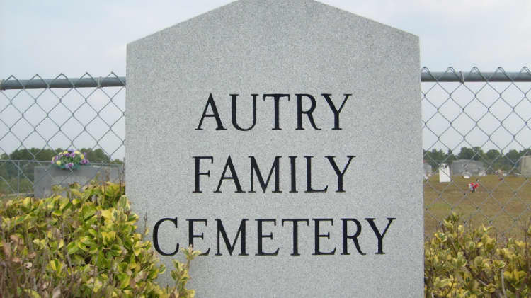
 

Autry Family Cem.


Cemetery Photo

William R Shatterly

In the Clement community, four miles south of the intersection of Autry Mill Road and Fayetteville Hwy (US 13) and one-half mile north of the intersection of Maxwell Road (SR-1006) and Autry Mill Road (SR-1446).

Hardy J Autry Cem.


In northwestern Sampson County at Hayes Mill Rd (SR-1445) and Faircloth Lane, 8/10 miles west of the intersection Hayes Mill Rd and Autry Mill Rd (SR-1446).

Molsey Autry Cem.


Also called the Wiley Autry Family Cem., located about 4 miles northeast of Autryville, Sampson County, North Carolina. This Cem. is on the left side of the road as you travel between Autryville and Salemburg, on what is called The Bonnettsville Road. It is just to the left of a private home.


Autryville Baptist Church Cem.


Is on Hwy. 24 across the road from the church.

Baggett Cem.


On Autryville Road about three miles west of Salemburg.

Baggett-Williams Cem. (Joe Moore Hill Cem)

Surveyed by Stacey Alder & Ashley Ellis April 2009

Maxwell Rd at Willowgrey Ln. Also called Joe Moore Hill Cem..

Bannerman Cemetery

Billie Shaw Powell

Near Kerr (a small, unincorporated town) in Sampson County, NC. The Cem. is about 1/2 mile from the South River, approximately three miles southwest of Harmony Driving directions to Bannerman CemeteryPresbyterian Church.


Barber Cem.


On Pine Ridge Rd just past Max Austin Ln and before you get to Maurice Pate Ln.

Barefoot Cem.


In northwestern Sampson County, 2 2/0 miles north of U S route 13 and near the intersection of Autry Mill Rd (SR-1446 and Wrench Rd (SR-1472). It is visible from this intersection. It was established about 1885.

Barefoot-Tew Cem.


On private property 2 miles south of U S route 13 near the intersection of Autry Mill Rd (SR-1446) and Maynard Rd (SR-1450).


"Be" Cemeteries

Back to the Top

William Bennett Cem.

Surveyed by Randy Jackson May 2001

On SR.1710, Emmet Thornton Rd. Sampson County, Newton Grove, NC, in middle of a field.

William Bennett Cem.    

Bethabara Cem.


At 5092 Maxwell Rd (SR-1006) at Bethabara United Methodist Church.

Bethany Pentecostal Free Will Baptist Church Cem.

Surveyed by Linda Vann, Oct. 2009


Bethesda Friends Meeting Church Cem.


At 4955 Greenpath Rd (SR-1005) near Dunn in northwestern Sampson Co.


Beulah Methodist Church Cem.


4610 Corinth Church Rd Roseboro

Black River Chapel Presbyterian Church Cem. Partial listing.

Surveyed by Billie Shaw Powell 2008
& Pam Bailey March 2009

From Ivanhoe Rd turn right on Eddie L Jones Rd. Church and Cem. will be on the right.

Bradshaw Cem.

Surveyed by Doug Bradshaw, Charles and Judy Bradshaw March 2008

Clear Run to the farm of Amos McLamb. Clear Run is located on Hwy 411 just before you cross the Black River. We were able to find the cemetery about a half mile from the road on Mr. McLamb’s farm. It is situated close to the banks of the Black River.


Raiford (Raeford) Brewington Family Cem.


On or off Brewington Road, and said to be on private land and neglected for many years


Bright Family Cem.


Location on K. Bryan Road and Taylor Bridge NC between Junior Lane and Bonham road (SR 1117) across Duplin Co. in Sampson Co.


"C" Cemeteries

Back to the Top


Cannady Cem.


Coming from Roseboro, go to Bonnetsville and turn right on Bass Lake Road. Not sure of the distance, but there is a sign on the left by the road that says "Hardy Royal Family Cem.". Cem. is down that path.


Carter Cem.


Location???

Chestnutt Cem.

Surveyed by Myra & Keith Lanier November 2007

On Cornwallis Road just past M. J. Johnson Road in a field on the right. This Cem. is on the Duplin-Sampson County line.


Clement Baptist Church Cem.


In the community of Clement at the intersection of Maxwell Road and Autry Mill Road, go west onto Maxwell Road less than a mile, just past Sivertson Road on the left. You will see the Baptist Church on the right or north side of the road. The Cem. is behind the church.


Clinton Cem.


Is in downtown Clinton on Hwy. 24--becomes Sunset Avenue


Corbett Cem.


From Newton Grove take Hwy 50/55 East (Mt. Olive Hwy) pass the intersection of Elbert Thornton Rd (SR 1710) and Corbett Rd (SR 1707). Go through for .08 mile. Cem. is on left.


Core-Dudley-Strickland Cem.


From Exit 72 on I-95 at Dunn, N. C. travel east seven miles on Spring Branch Road (SR1002) until you see Smiley's Convenience Store on your left. It is a brick building. Turn left at store. You will be on Alderman Mill Road or SR1605. Travel one mile. You will see a dirt path on your left just before your reach a brick home on the left. The Cem. is located on the left a few hundred feet down the dirt path. IMPORTANT: Stop at brick home and ask permission to go to the Cem..


Neil Culbreth Cem.


About 2 miles north of Roseboro,NC. It is on State Hwy. 1002


"D", "F" Cemeteries

Back to the Top

Faircloth Cem.

Surveyed by Sharon Dover Romanek July 2003

From Highway 24 between Autryville and Roseboro going west you will come to Horseshoe Road, which turns to the right and is a loop road that joins back up with Highway 24. Turn onto Horsehoe Road. Nirvana is a dirt road that turns off to the left from Horseshoe Road. The Cem. is about a mile off Horseshoe Road. Although the road leading back is dirt is it a good quality dirt road.

Raiford Faircloth Cem.

Surveyed by Sharon Dover Romanek November 2004

From Autryville, going toward Roseboro take Autryville Road west. Stay on Autryville Road for about 5 miles. Just past Hitching Post Road there will be a dirt road on your immediate left that leads back into a field. Turn left onto it, and go straight back to where the grove of trees is. The Cem. is just behind the grove of trees up on a small hill in the middle of a farming field.

Jimmy Field Cem.


in the Clement Community in northwestern Sampson County at a point one mile north of Maxwell Rd (SR-1006) and 500 feet west of Waterpoint Rd (SR-1442). In the middle of a field and fenced.

Fisher Cem.

Surveyed by Sharon Dover Romanek April 2006

From Fayetteville, NC take highway 24 east to Autryville. From Autryville turn left onto Autryville Road . This will be an intersection about 1 mile into Autryville just as you are preparing to leave Autryville which is a VERY small town. There is a Cem. on the right and a large brick church on the left corner where you will turn. Continue for about 3 miles. You will pass Punkin Town Road on your right. You should see the Cem. on your left about 1 mile past Punkintown Road. It is a very small Cem. and is just before Dewitt Williams Road which is also on the left.


Fryar Cem.


Ingold Community


"G" - "Hi" Cemeteries

Back to the Top

Goodman-Hunt Cem.

Surveyed by Stacey Alder & Ashley Ellis April 2009

2000 block of Autry Mill Rd.. Godwin, NC


Grandview Memorial Gardens


From Clinton 3 miles north on Hwy 421 North – Across from Dudley’s Home Furnishings

Amos Hall Cem.


Small Family Cemetery located in Northwestern Sampson Co
between South River Rd (SR-1424) and Sivertsen Rd (SR-
1425).

Daniel Hall Cem.

Surveyed by ? November 2005

850 Jordan Road, 1 mile west on Jordan (SR 1484) from the intersection of South River Road (SR 1424) and Jordan Road (SR 1484). The Cem. is on the left.


Halls United Methodist Church Cem.


Cemetery Photo


From NC Hwy 24 in Autryville go north on N Gray St which becomes Minnie Hall Rd (SR-1414). Go 4.5 miles to the intersection of Carroll Store Rd (SR-1430). The Cem. will be at this intersection. The church is located six-tenths mile west at 4621 Minnie Hall Rd.

Harrell Family Cem.


At Harrells Crossroad turn right on Highway # 421 Cem. is 1 mile in the fork of road. Cem. is on Duplin-Sampson County Line

Dempsey Haywood Hayes Cem.


Family Cemetery located in the Clement Community

>>Dennings in Hill Crest Cem.    

Joe Moore Hill Cem. (white)


Maxwell Rd at Willowgrey Ln

Joe Moore Hill Cem. (black)    


Hillside Cem.


At the corner of Friday and Alex Benton Roads, Newton Grove


"Ho" Cemeteries

Back to the Top


Hobbs Cem.


On 701 south from newton grove to monks crossroads, turn left on cedar point rd.(SR 1745) turn immediate right on Lassiter rd. (SR 1714) go 0.6 miles Cem. on the right


Hodges Chapel Church Cem.


Location???


Old Holly Grove Free Will Baptist Church Cem.


Clinton, Rte 2


Hollywood Cem.


From Roseboro, take Hwy 242 North. Go for 0.5 miles. Cem. is on the right.


Home Cem.


Location???

Honeycutt Cem.


About nine miles northwest of Clinton, NC at the intersection of High House Rd (SR-1006) and Honeycutt Rd (SR-1325).


Honeycutt-Matthews Cem.


Cemetery Photos


Start from Autryville, NC at the intersection of US Hwy 24 and N. Gray St. Go .4 mi north on North Gray Street, which becomes Minnie Hall Rd (SR-1442) and go 1.7 miles. Turn left onto Sivertson Rd (SR-1425). and continue for 4.5 miles. Turn right onto Maxwell Rd and go 1.4 miles to Waterpoint Rd (SR-1442), then left ont Waterpoint. Cem. will be .2 mile on the left on a knoll.

Honeycutt's Request Primitive Baptist Church Cem.


From the Cumberland/Sampson Co line (South River) go 2 miles northeast on Fayetteville Hwy (US-13) to Baptist Chepel Rd (SR-1451). Turn right on Baptist Chapel Rd. The Cem. and church will be 2/10 mile on the left next to the road.

Hopewell United Methodist Church Cemetery


4641 Church Rd
Newton Grove, NC 28366

George Horne Cem.


On South River Rd (SR-1424) about 4 miles north of Autryville, NC at a point one-half mile west of it's intersection with Delmore Rd (SR-1423).


"I", "J" Cemeteries

Back to the Top


Ivanhoe Baptist Church Cem.


It is in the Ivanhoe community in Southern part of the county

Jackson Family Cem.

Surveyed by Randy Jackson March 2005

Leaving Newton Grove on NC 55 Mount Olive Highway it will be .2 miles past Pleasant Union Christian Church on the right in wooded area back of field.

Jackson Family Cem. #2   From Hwy 421 (Clinton to Dunn) make a left onto Feed Mill
Road. From there make a right onto Williams Lake Road. The
cemetery will be on the right side of the road. It is
neatly kept and very accessible.

Jackson-Tew Cem.


2.8 miles north of Sampson Co/Cumberland Co line on Hwy 13 (personal property)

John Curtis Jackson Cem.


150 yrs. southwest from sr 1620 from a point of 0.43 miles southeast of sr 1630 in plain view township, Sampson county, Dunn, N.C.

Mark D Jackson Cem.


in northwestern Sampson County in a field near 888 Hummingbird Lane (private rd). Hummingbird Lane starts at Fayetteville Hwy (US-13) and runs north to Alvin Rd (SR-1601)

William C Jackson Cem.


Family cemetery located in northwestern Sampson County


Johnson Cem.


Harrells...Location???; Delway...Location???; Stedman...Location???

Justice Cem.


On Cabin Museum Rd near Cotton Ln on the side of the road.


"K", "L", "M" Cemeteries

Back to the Top

Keener Methodist Cem.

Surveyed by Linda W. Vann Aug. 31, 2009 and Nov. 01 2009

Seven miles from Clinton on Highway 701 North, left onto SR 1746 (Keener Road)
Go 0.3 miles, church and cemetery are on the right.


Kelly Cem.


Kerr Cem.


Charles Shaw King Cem.


Cemetery Photos


Henry King Cem.


Cemetery Photos


James King Cem.    

Littlefield Missionary Baptist Church Cem.

Surveyed by Linda Owens & Alice Ferguson November 2008

Rosin Hill Road between McLamb’s Crossroad and Rosin Hill/Newton Grove Highway (Off Highway 13 that runs from Newton Grove through Spivey’Corner)

John Matthews Cem.


on High House Rd (SR-1006) at its intersection with Huntley School Rd (SR-1434).

Shadrick Matthews Cem


n the Clement Community of Sampson Co., N. C. at a point 3/0 mile north of Maxwell Rd (SR1006) and 2/0 mile west of Waterpoint Rd (SR-1442). It is on private property in the center of a livestock pasture. Permission is required to visit

Maxwell Cem


bout 1 ˝ miles west of Clement in Dismal Township at the southeast corner of the intersection of Maxwell Road (SR 1006) and Halltown Road (SR 1427).

McGee United Methodist Church Cem


1100 McGee Church Rd., Clinton From the intersection of US Hwy 421 and NC Hwy 24 in Clinton, travel north on US 421 one and one-half miles to Five Bridge Rd (SR-1311). Turn left onto Five Bridge Rd and continue 3.5 miles to McGee Church Rd. The cemetery and church will be visible on the right.


McLamb Colored Cem


Salemburg ~ Location???

McLemore Cem

Surveyed by Sharon Dover Romanek December 2004

Take Highway 24 from Fayetteville heading East toward Autryville. Continue 3.3 miles from the caution light at Autryville to the Hayne Exit road which becomes the Hayne Stretch Road after about 100 yards. It is then 4 miles to William’s Lane . There will be a small wood frame home directly across from the road. This is where William Lane Williams resided while still alive. Turn left onto Williams Lane and follow it about 1/4 mile or so. It will be a dirt road and will go through a heavy residential area where homes are very close to each other. The dirt road will curve to the right back behind some houses and the cemetery is on the left. This is a VERY congested area, so caution MUST be used if visiting the cemetery at all.

Mill Creek Baptist Church Cem


Mill Creek Baptist Church Rd Roseboro

Mill Creek Church Road Cem


Moore Family Cem


Off Cabin Museum Rd between Brock Ln and Walter Moore Ln. There is a long path to the cemetery.

Mt Carmel Church of God of Prophecy Cem

Surveyed by Sharon Dover Romanek July 2003

From Autryville, going toward Roseboro take Autryville Road west. Stay on Autryville Road for about 4.8 miles. Turn left onto Leroy Autry Road. Go about 1/4 mile and the cemetery is on the right.


Mt Elam Cem


2211 Mount Elam Church Rd Roseboro


"N", "O", "P" Cemeteries

Back to the Top


Joseph Naylor Cem


about 1 1/2 miles northwest of Mingo . From Spring Branch Road (S.R. 1002) east .10 miles on Aman Dairy Road (S.R. 1601) north about 170 yeard along the west side of the pasture fence. It can be seen from the road but is behind a point between a couple of houses. S.R. 1002 leaves Dunn and crosses I-95 at Exit 72 as Pope Road which becomes Spring Branch Church Road as it crosses into Sampson County. Aman Dairy Road is about 8 miles almost due south of Exit 72 (Pope Road Exit - Dunn) and after passing Spring Branch Church. Smiley's Store us on the northeast corner where you want to turn to the east.


Oak Grove Pentecostal Free Will Baptist Church Cem


6535 Oak Grove Church Rd Stedman


Oak Plain Presbyterian Church Cem


Near the Duplin-Sampson County line on Highway 1120, west of Rose Hill, N. C

Old County Cem


on Hollingsworth Rd, just off NC 50 in Suttontown area. It is about 1.3 miles on the left behind the Old Whit Sutton residence in a field.

Parkersburg Missonary Baptist Church Cem    

Point Level Church Cem

Surveyed by Linda McLamb Owens July 2008

from Clinton, NC US 421 NORTH Drive about 9.5 miles Turn RIGHT onto WYRE BRANCH RD – Drive about 1 miles Turn RIGHT onto VANN RD – Drive about .6 miles Point Level Church Cemetery is on the Right


Powell Cem


Pridgen Cem


"R", "S", "T" Cemeteries

Back to the Top

Raynor Family Cem


Just outside of Newton Grove off Hwy 13 on Friday Rd on a private farm. There are about three mobile homes parked in a line along Friday Rd. Beside one is a dirt road that goes a short distance to the back of the field. At the end of the dirt road is a tall clump of trees that can be seen from the road.


Royal Cem


Taking 242 from Salemburg towards Midway, right after you go through the intersection of 242 & High House Road, at Piney Green Baptist Church, there is a road that turns to the left, Royal Road. There is a cemetery just a short ways on the left


Hardy Royal Family Cem


Coming from Roseboro, go to Bonnetsville and turn right on Bass Lake Road. Not sure of the distance, but there is a sign on the left by the road that says "Hardy Royal Family Cemetery".


Running Branch Church Cem


354 Running Branch Rd off Highway 421, Clinton

Salemburg Cem

Surveyed by Bobby Tripp June 2009

Across the road from Salemburg Baptist Church on Bearskin Rd Salemburg. Behind the Family Life Center

Solomon Sessoms Cem


Shady Grove Baptist Church Cem


Hwy 13 between Newton Grove and Spivey's Corner

Shiloh Pentecostal Holiness Church Cem

Surveyed by Stacey Alder & Ashley Ellis April 2009


Sloan Family Cem


On Hwy # 701, between Garland and South River, Sampson County, N.C. About 3/4 miles south of Garland, right side of highway, on a hill.


Smith Chapel Church Cem


Parkersburg, McDaniels Township

Spell Family Cem


on State Road 1002, (also called Dunn Road) in the Spelltown Community. It is on the Dunn to Roseboro Road. It is approximately five mile west of Salemburg, N.C.

Murdock F Starling Cem


From Autryville, NC (NC Hwy 24) take North Gray St (SR-1414). N Gray St becomes Minnie Hall Rd (SR-1414) Go 2 2/10 miles to South River Rd (SR-1424). Turn left onto South River Rd. Go 3 3/10 miles to a dirt lane on the left beside a large oak tree and an old house. The cemetery is 3/10 mile down the dirt lane on the right. This small family cemetery is located on private property owned by Mr. & Mrs. M. F. Starling. One should obtain permission to visit it.


Stokes Family Cem


on County Road 1943 (Waycross Road), 0.52 mile north of County Road 1945 (Trinity Church Road) in the Waycross Community


Sunrise Memorial Gardens


From Roseboro take Hwy 242 North for 3 miles. Cemetery is on the left.

Tyndall Cem


On the west side of Tew Rd (SR-1452) about 7/10 mile south of its intersection with Wrench Rd (SR-1472).

"U", "V", "W" Cemeteries

Back to the Top


Unknown Cem


Hayne area on Carey Bridge Rd off Hwy 24. Take Hwy 24 west, 5 miles from Roseboro. Turn right on Carey Bridge Rd (St Rd 1256) go 1.7 miles cemetery on the right.


Unknown Cem


Mill Creek Church Rd in Roseboro


Vinson Cem


off of Hayne Stretch Road (SR1255). Turn left off of Hwy. 24 (coming from Roseboro) onto Hayne Exit Road, it becomes Hayne Stretch Road. Go about 2.5 miles, then turn right into a dirt field. Go 0.2 mile where the field & the woods me, and the cemetery is on the left.

J. Frank Warren Cem

Surveyed by Linda W. Vann Nov. 01 2009

From Clinton, take US Hwy 701 to Monks Crossroads turn left on to Rosin Hill Road. Cemetery is on the left just past intersection with Whit Road (SR 1843)

Warrick Cem


on Hollingsworth Road, 600 feet off of NC 50 Hwy., on the right, by an old cedar tree that stands alone

William Bright Warrick Cem

Surveyed by Randy Jackson March 2005

On (SR. 1814) Juniper Rd. Sampson Cty Newton Grove, NC.Near Houses Mill in the middle of field.


Wells Chapel Cem


On U. S Hwy # 41, west of Wallace, and near the Duplin and Sampson County Line, The highway divides the cemetery with the church on the south side of the Highway


West Cem


From Magnolia take Academy Street it will run into Isham Frederick Road (SR1114). About 10 miles turn left on Buck Hall Creek Road (Sr1113). About 1/2 mile turn left on Carroll road (SR 1108) Cemetery is on right about 3/10 miles in a field. Cemetery is close to the Sampson County Line. Very undergrown

C A Williams Cem

Surveyed by Sharon Dover Romanek April 2004

Going east from the Fayetteville area of North Carolina on Highway 24(Clinton Road) to Autryville, NC, take Autryville Road left. You will have a cemetery on your right at this intersection, and a church on the left ahead of you. To the right this same street is known as Church Street. Go 4.3 miles. Turn left on Leroy Autry Road; go about a 1.2 mile and turn left between some houses. There is no marker pointing the way to the cemetery, but any neighbor in the area will know of the location of the cemetery. You will wind back in on a dirt road to the cemetery, which is surrounded by farming fields and woods

Williams - Best Cem

Surveyed by Linda W. Vann Nov. 01 2009

From Clinton, take US Hwy 701 to Monks Crossroads turn left on to Rosin Hill Road. Cemetery is on the right just past intersection with Houses Mill (SR 1804)

Williams - Britt Cem

Surveyed by Linda W. Vann Nov. 01 2009

Seven miles from Clinton on Highway 701 North, turn left onto Kenner Road (SR1746). Cemetery is on left at intersection of Kenner Road and Basstown Road.


Edward S Williams Cem


Location???


James Thomas Williams Cem


1 1/2 miles eastnortheast of Clement, 60 yeards southeast of a dirt road at a point 70 yeards northeast of S R 1441 at a point 0.13 miles north of S R 1006 (Maxwell Rd) in Dismal Township


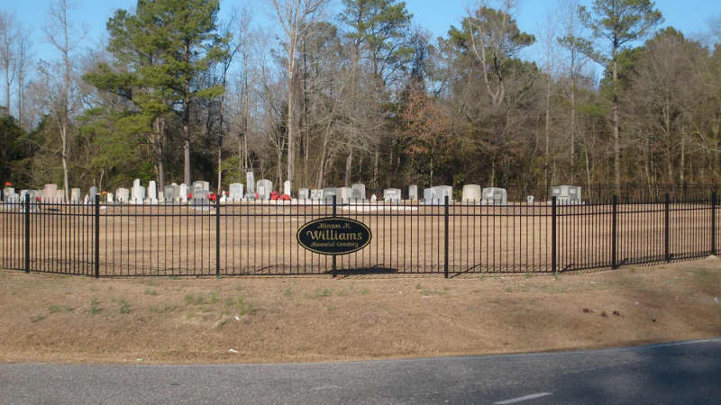
Minson M Williams Memorial Cem


Cemetery Photo


about 8 miles north of Autryville, NC at the intersection of Maxwell Rd (SR-1006) and Welcome School Rd (SR-1441) and eight-tenths mile west of Clement Elementery School.

Noah Williams Cem

Surveyed by Linda W. Vann Nov. 01 2009

From Clinton take Hwy 421 North to Spivey's Corner. Turn right on Hwy 13 (Newton Grove highway). Turn left onto Timothy Road (SR 1620). Turn right on Watery Branch Road (SR 1638). Cemetery is on right just prior to Maple Grove Church Road (SR 1635)

William Reddin Williams Cem


North of S.R. 1419 1/4 mile northeast of S.R. 1233 (Dewitt Williams Road)


Williamson Family Cem.


Cemetery Photos


Wright Cem.


off of Emmett Jackson Road (Sr1302) turn right on Bradshaw Crow Road (SR 1321) Cemetery is .1 mile before you reach Sampson County of the right side of road Very undergrowth