|
|
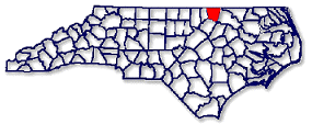
Warren County, North Carolina
and our neighborsWarren and Franklin Counties were formed in 1779 from Bute County which had been established in 1764. For several years the inhabitants of Bute had longed for a division of the county because of the hardships to fulfill civil duties from the remote parts of the very large county. On 26 April 1777 Mr. Benjamin Seawell introduced a petition in the North Carolina General Assembly from the several inhabitants of Bute for a division of the County. For some reason the division was not made. Two years later, in 1779, Mr. Edward Jones introduced another petition 'for the division. A bill was slated and enacted into law on 20 January 1779:
.... That from and after the passing of this Act the County of Buts shall be divided into two distinct Counties by a direct line from the Granville line to Halifax or Nash County line as the case may be, leaving in each part or division an equal quantity of Acres as near as can be ascertained ... and all that part or division which lies North of said line and adjacent to Virginia shall be a distinct County by the name of Warren, and all that part or division that lies South of said line shall be a distinct County by the name of Franklin;.. (SRNC, XXIV, 227)
On 29 January 1779 the General Assembly meeting at Halifax appointed the Commissioners for dividing Bute County. Julius Nichols, John Faulcon, William Duke, John Norwood, and Matthew Thomas were to be responsible for measuring the bounds of Bute County, running the dividing line, and choosing sites near the center of each county whore courthouses and public buildings were to be built. Later in 1779 two other acts of Assembly established Warrenton and Louisburg as County Seats of Warren and Franklin Counties respectively,
In 1786 Warren County annexed more territory, a part of Granville County:
.... Beginning at the point where the line of division between Warren and Granville Counties shall touch the line of division between this State and the State of Virginia, and running thence west along the said line to Nutbush Creek, thence up said creek as it meanders to the mouth of Anderson's Swamp, thence up the said swamp to the fork, thence up the south fork of the said swamp to Stark's mill, thence 'by a line to be run due south until it shall touch the aforesaid line of division between Warren and Granville, be, and the same is hereby annexed to and shall remain a part of the County of Warren .... (SRNC, XXIV, 866)
Warren County remains today the same except for a western part which was cut off to form a part of Vance County when it was formed in 1881.
Bute Co. was formed from Granville Co. in 1764 and abolished in 1779 when it was divided into Warren Co. and Franklin Co. The courthouse of Bute Co. was located at a place called "Buffalo Rice Path" on land owned by Jethro Sumner about 6 miles southeast of present Warrenton, North Carolina. Most of the records of Bute County are still located in Warren Co. though some may be found in Franklin Co.
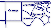
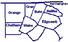
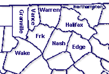
Warren County, North Carolina County Area in 1760
County Area in 1770 County Area Today
From the above maps you can see than anyone doing research in Bute Co. should also check for their ancestors in Granville, the parent Co. as well as the present counties of Vance, Franklin, Wake, Northampton, Halifax and Nash. We do hope you will visit our neighboring counties. Warren County Communities & Townships they are or were located in
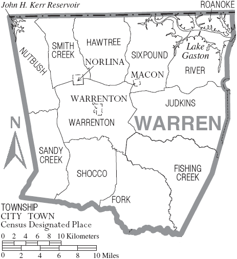
Afton Shocco North Carolina Arcola Fishing Creek North Carolina Aspen (small community in Eastern Warren Co., discontinued 1915) Judkins North Carolina Axtell Sandy Creek North Carolina Church Hill Six Pound North Carolina Elams Roanoke North Carolina Elberon Sandy Creek North Carolina Embro Judkins North Carolina Enterprise River North Carolina Five Forks Six Pound North Carolina Grove Hill (fork of Grove Hill Rd & Arcola Rd) Fishing Creek North Carolina Inez Fork North Carolina Jerusalem Church Hawtree North Carolina Liberia Warrenton North Carolina Lickskillet Shocco North Carolina Littleton (officially became part of Halifax Co. in July 1974) River North Carolina Macon Six Pound North Carolina Manson Sandy Creek North Carolina Marmaduke Fishing Creek North Carolina Merry Mount (extreme northern part of township) Hawtree North Carolina Norlina Smith Creek North Carolina Oakville Hawtree North Carolina Odell Fishing Creek North Carolina Oine Smith Creek North Carolina Old Bethlehem Fishing Creek North Carolina Parktown Shocco North Carolina Paschall Hawtree North Carolina Ridgeway Smith Creek North Carolina Rose Hill Nutbush North Carolina Snow Hill Warrenton North Carolina Soul City Nutbush North Carolina Vaughan Judkins North Carolina Vicksboro Sandy Creek North Carolina Warren Plains Fishing Creek North Carolina Warrenton Warrenton North Carolina Wise Hawtree North Carolina Warren County Townships
(click image to enlarge map)
Current Warren County Townships:
Fishing Creek Township
Fork Township
Hawtree Township
Judkins Township
Nutbush Township
Roanoke Township
River Township
Sandy Creek Township
Shocco Township
Smith Creek Township
Sixpound Township
Warrenton Township
--------------------------------
Townships through the years
While most Townships or Districts existed in Warren County since its beginnings, they were not always identified in Census records. The following are the Townships that were listed in the Federal Census years of 1850 thru 1930.
1850
1860
Nutbush District
Warrenton
Sandy Creek District
(other townships not indicated)
Warren District
Warrenton
1870
1880 Township No. 1 - River Township Fishing Creek Township Township No. 2 - Six Pound Township Fork Township Township No. 3 - Hawtree Township Hawtree Township Township No. 4 - Smith Creek Township Judkins Township Township No. 5 - Nutbush Township Littleton Township Township No. 6 - Sandy Creek Township Nutbush Township Township No. 7 - Shocco Township River Township Township No. 8 - Fishing Creek Township Sandy Creek Township Township No. 9 - Judkins Township Shocco Township Township No. 10 -Warrenton Township Six Pound Township Smith Creek Township see 1874 Map Warrenton Township 1900 1910 Fishing Creek Township Fishing Creek Township Fork Township Fork Township Hawtree Township Hawtree Township Judkins Township Judkins Township Nutbush Township Nutbush Township River Township River Township Sandy Creek Township Roanoke Township Shocco Township Sandy Creek Township Six Pound Township Shocco Township Smith Creek Township Six Pound Township Warrenton Township Smith Creek Township Warrenton Township West Warrenton Township 1920 1930 Fishing Creek Township Fishing Creek Township Fork Township Fork Township Hawtree Township Hawtree Township Judkins Township Judkins Township Nutbush Township Nutbush Township River Township River Township Roanoke Township Roanoke Township Sandy Creek Township Sandy Creek Township Shocco Township Shocco Township Six Pound Township Six Pound Township Smith Creek Township Smith Creek Township Warrenton Township Warrenton Township Descriptions of some Warren County Locations Seen in Records, North Carolina Gazetteer, by William S. Powell:
Fishing Creek:
rises in E Vance County and flows NE in Vance and Warren Counties and SE and S in Warren County to the Franklin-Warren, Halifax-Nash, and Halifax-Edgecombe county lines to a point approx. 7 mi. N of Tarboro. From there, it flows S to enter Tar River. It appears as Great Fishing Creek on the Moseley map, 1733, and on the Collet map, 1770.
Fishing Creek Township: SE Warren County.
Not to be confused with nearby Fishing Creek Township, E central Granville County. Fishing Creek District had 59 heads of families in 1790.
Little Fishing Creek:
is formed in E central Warren County by the junction of Walkers Creek and Big Branch. It flows SE into W Halifax County, where it enters Fishing Creek on the Halifax-Nash county line. Appears as Conway Creek on the Moseley map, 1733, and as Little Fishing Creek on the Collet map, 1770.
Hawtree Creek:
rises in N central Warren County and flows N into Virginia, where it enters Roanoke River. Appears on the Moseley map, 1733.
Littleton:
town in E Warren County and NW Halifax County. Alt. 389. Inc. 1877 and named for Little Manor (Home of William Person Little, state senator from Warren County: 1804-1806. The house was built in 1780 and is still standing) Person's Ordinary, the tavern owned by Thomas Person (1733-1800), Regulator, officer of the Continental Line, and state legislator, was located there and is shown on the Collet map, 1770. The tavern, which is still standing, was called Peterson Inn on the Price map, 1808. Littleton was mentioned by name in newspapers as early as 1823, and in 1831 a post office was est. there under the present name. The MacRae map, 1833, shows Littleton as an established community.
Additional: Originally Littleton was divided between the counties of Warren and Halifax,but in July 1, 1974 an election was made to make Littleton only to be a part of Halifax County
Middleburg-Nutbush Township:
E Vance County. Two separate townships were merged in 1965.
Nutbush: See Williamsboro.
Nutbush Creek:
rises in city of Henderson in central Vance County and flows N into Kerr Lake. Shown on the Moseley map, 1733.
Nutbush Township: See Middleburg-Nutbush Township.
Roanoke Township: NE Warren County.
Not to be confused with the nearby locations of Roanoke Township in E. central Northampton County, nor Roanoke Rapids in Northern Halifax County.
Sandy Creek:
rises in SE Vance County and flows SE across Warren and Franklin Counties and into Nash County, where, in Hilliardston community, the name is changed to Swift Creek, which see.
(Note: there are 8 Sandy Creeks, plus a Big Sandy Creek, and Little Sandy Creek, & 3 Townships in NC; they are in Wilkes, Alamance, Cumberland, Davidson, Durham, Granville, Randolph, Franklin, Vance & Warren)Shocco:
community in N Franklin County. Site of popular nineteenth-century springs and resort.Shocco Springs:
former health resort in s(outh) Warren County on Shocco Creek. Located approx. 9 mi. s(outh) of the city of Warrenton, it was famous in the nineteenth century as a social, recreational, and health resort built around mineral springs. Shocco Male Academy was located here. Neither is in existence any longer. Shocco Springs had a post office from 1832 until 1866, and was shown on the Price map, 1808.
Shocco Township, S(outh) Warren County:
Shocco Creek rises in e(ast) Vance County and flows se through Warren County onto the Franklin -Warren County line where it enters Fishing Creek. Shown on the Price map, 1808. Named for the Shoccoree Indian Tribe.Shocco Creek:
rises in E Vance County and flows SE through Warren County onto the Franklin-Warren County line, where it enters Fishing Creek. Shown on the Price map, 1808. Named for the Shoccoree Indian tribe.Sixpound Creek:
rises in N central Warren County and flows N then NE into Lake Gaston. Appears on the Moseley map, 1733.
Smith Creek:
rises in W Warren County and flows NE into Mecklenburg County, Va., where it enters Roanoke River. Shown on the Moseley map, 1733, as Great Creek but appears by the present name on the Price map, 1808._________________________________________________________________________________________________________ Copyright 2002 to present by Deloris Williams, Nola Duffy, Ginger Christmas-Beattie for the NCGenWeb Project. No portion of anything on this site is to be used for anything other than personal research. Any republication or reposting is expressly forbidden without express written consent of the owner. This page was last updated on 04/30/2021