 |
NCGenWeb
|
 |
|
The Lost Colony
|
||
|
North Carolina, British researchers
find clue to location of Lost Colony
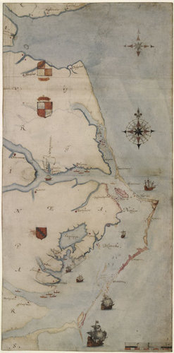
A map in the British Museum holds an intriguing clue By Jay Price Posted: Thursday, May. 03, 2012 "La Virginea Pars”, a map of the east coast of North America
(c. 1585-87) produced by the Elizabethan artist and gentleman, John
White (P&D 1906,0509.1.3, c. British Museum).
Researchers at the British Museum in London, prompted by questions from an amateur historian who teaches economic development at UNC-Chapel Hill, found a symbol hidden for centuries under a patch on an Elizabethan map that could show where the settlers of the Lost Colony went after they vanished in 1587. The missing colonists, it turns out, may have moved to what is now an Arnold Palmer-designed golf course in Bertie County. The discovery was announced Thursday at UNC’s Wilson Library by a panel from a Durham-based group of historians and archaeologists named the First Colony Foundation and two scholars at the British Museum, who appeared via video webcast. -------------------------- Updated in June 2020.
In more recent discoveries, archeologists may have solved the
mystery of the Lost Colony.
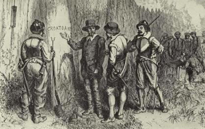
Hatteras Island is thought to be one place the colonists went,
after abandoning their new home (which became Dare County NC). The
island was formerly named after the Croatoans, a Native American
tribe who lived there. Emergency medical technician and part time
archaeologist Scott Dawson is one of today’s residents.
He has written a book detailing his findings that suggests that
John White knew exactly where the colonists had gone and that a
number of them had assimilated with the Native Americans. More can
be read in the stories below.
|
"La Virginea Pars”, a map of the east coast of North America (c. 1585-87) produced by the Elizabethan artist and gentleman, John White (P&D 1906,0509.1.3, c. British Museum). |
|
June 2020: Study Suggests the Mystery of the Lost Colony Solved |
|
|
Lost Colony Research: |
|
| List of Participants in Roanoke Voyages: The Lost Colonists | The Lost Colony Center |
| >>>Lost Colony Center: Current Research | Read latest research news & papers |
| What is the Truth About the Lost Colony? New Insight (Nov.2015) | Coastal Carolina Indian Center |
| Lost Colony YDNA Project (newest results) | FamilyTreeDNA Lost Colony if Roanoke |
| Lost Colony Research Group: Genealogy, DNA, Archaeology (old site) | FamilyTreeDNA Research Group |
|
Contact: NCGenWeb State Coordinator
|
|
Last updated: January 26, 2024 |
|
|