
![]()
![]()
Currituck Co., NC Extant Voter Registrations of 1867
by Frances Holloway Wynne
© 1992
![]()
One of the more helpful but under-utilized resources available for genealogical use is the 1867 Voters Lists of some of the Southern states. The voters lists were created during the Reconstruction period shortly after the Civil War. The lists are county wide registrations of white and African-American males over the age of twenty-one who were eligible to vote for delegates in the state constitutional conventions of 1867-1868. This list is historically interesting because it is the first showing of full names of black voters, many of whom were former slaves. Because the registrations contain the names of men living in each county, the registrations could be considered a substitute census. The registration lists contain the names of the registrants and their length of residence in the state, the county and the precinct.
There are many men who were excluded and would not have been included on the registration list. Among those would be men who served in the Confederate military in the rank of Major or above, those who served at any time in their lifetime in any elected or appointed governmental position and those who owned more than $20,000 in personal property. It is readily understandable why a militia officer during the rebellion would be denied the privilege of voting, but one wonders why an overseer of highways, a lighthouse keeper or a post master would be excluded. These latter hardly seem to be key governmental decision-making positions. Men in the excluded classes lost their United States citizenship and were required to apply to the President of the United States to regain it. When a person already registered was decided not to be entitled to registry, the following note was inserted after his name: "Stricken out April __, 1868", but the name was not erased.
When the law definitely required a one-year residency, one wonders why some potential voters were accepted after showing less time. Some voters were challenged and rejected with no explanation while on others the registrars went into great detail to explain rejection. There us no explanation for some names being stricken, but yet there were indications of acceptance for voting. Even though the voting age was supposedly 21, there are a few indications that not all voters were that age.
Lists of voters are found in most, but, not all Southern states. There are no known lists for Virginia and the border states of Tennessee, Kentucky, Missouri and Maryland did not suffer the agony of Reconstruction and were not required to register.
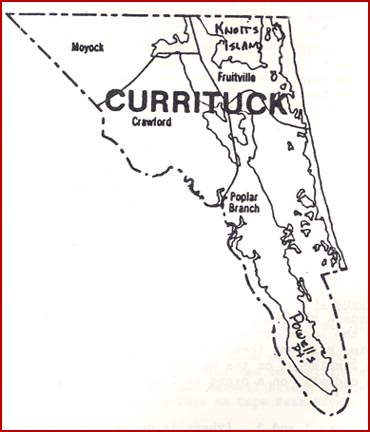
Currituck County Township Descriptions
The county is so formed, being intersected by water courses and by islands detached from the mainland, the commissioners, N.E. Baxter, Chm. Board Commiss., have thought it best, for the convenience of the inhabitants, to divide it into five townships as follows:
MOYOCK TOWNSHIP - Commencing on North Landing River on the Virginia line, following said river and Currituck Sound in a southern direction up to a place known as the Launch, thence west across Tulls Creek Bay to the mouth of Tulls Creek thence up said creek to the head of New Bridge Creek thence west to the Camden Co. line, thence along said county line to the Virginia line, thence along said line to the beginning. This township includes the precincts of Moyock, Tulls Creek and Gibbs Woods. Board: W.H. Cowell, Jno. W. Evans, Richard Etheridge - 14 Sep 1867
POPLAR BRANCH TOWNSHIP - Commencing on the Atlantic Ocean at the south line of Fruitville Township running south along said ocean to Caffees Inlet from thence due west course across the beach to Currituck Sound thence south across said sound to the south end of Powells Point, thence around said point to Camden line, thence down said line to the south boundary of Crawford Township, thence from the west mouth of Albemarle and Chesapeake canal through said canal across Currituck Sound touching the north end of Churches Island to the head of Ship Bay, thence from the head of Ship Bay running a due east course to the beginning. This township embraces Narrow Shore, Church's Island, Poplar Branch, Powells Point and that portion of the beach beginning from the head of Ship Bay running south to Caffees Inlet. Board: Robert S.D. Holbrooke, Samuel Dowdy, George Baum - 19 Sep 1867
CRAWFORD TOWNSHIP - Beginning at the Launch, binding Currituck Sound, running in a southern direction to the Albemarle & Chesapeake canal, thence down said canal to North River, thence down said river to the Camden line, thence along said line until it intersects the line of Moyock township. This township includes the precincts of the Court House & Indian Ridge and that portion of Coinjock precinct lying north of the canal.
FRUITVILLE TOWNSHIP - Commencing on the Atlantic Ocean at the Virginia line, running south along said ocean to a point due east from Ship Bay in Currituck Sound, thence running across the beach due west to said bay, thence across Currituck Sound to the Launch, thence following the eastern boundary of Moyock Township to the Virginia line, thence along said line to the beginning. This township embraces Knotts Island, Mackeys Island, Crow Island, Morse's Point, Monkey Island and that portion of the beach land from the Virginia line south to the head of Ship Bay.
NAGS HEAD TOWNSHIP - Commencing at Caffees Inlet on the Atlantic Ocean running south along said ocean to the Hyde Co. line, thence across the beach along the Hyde Co. ling to Pamlico Sound, thence north up said sound to the south end of Roanoke Island, thence up Croatan Sound along the west side of said island, thence across the mouth of Albemarle Sound, thence up Currituck Sound to Caffees Inlet, thence due east course to the beginning. This township embraces North Banks, Roanoke Island, Nags Head and Bodys Island.
LINKS TO SURNAMES
![]()
|
|
|
|
|
|
|
|
2004 Kay Midgett Sheppard