
Return to Currituck Co.
![]()
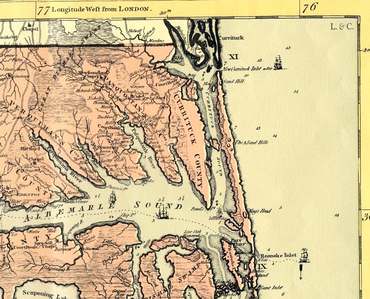
1775 Map (partial) by Henry Mouzon, Jr.
This map is entitled An Accurate Map of North and South Carolina with their Indian Frontiers, Shewing in a distinct manner all the Mountains, Rivers, Swamps, Marshes, Bays, Creeks, Harbours, Sandbanks and Soundings on the Coasts; with The Roads and Indian Paths; as well as The Boundary or Provincial Lines, The Several Townships and other divisions of the Land In Both the Provinces and is dated 1775. Mapmaker and civil engineer, Henry Mouzon, Jr. (1741-1807) was the grandson of a Huguenot immigrant to South Carolina who held land grants in Berkeley County. Henry, Jr. was born in Craven (now Williamsburg) County, South Carolina. After his father’s death in 1749, eight-year-old Henry Jr. was sent to France for his education, where it is presumed that he learned mapmaking skills. He received his first important public commission in 1771, when he and Ephraim Mitchell (subsequently the surveyor general of South Carolina) were appointed by Governor Lord Charles Greville Montague to survey the boundaries of the civil districts of South Carolina. In May 1774, Mouzon advertised a proposal for a corrected map of South Carolina to be issued the following January. When the map was published, it included both North and South Carolina and corrected some of the mistakes of the two previous maps of the area—James Cook’s 1773 map of South Carolina and John Colett’s 1770 map of North Carolina. American, British, and French forces used this map during the American Revolution. George Washington’s copy is owned by the American Geographical Society. Names of owners of plantations and other settlements appear on the map.
![]()
![]()