Return to Currituck Co.
![]()
Currituck County Estates
![]()
Sandford Doxey - 1877
17 Sept 1877 - Summons for Relief. S.D. DUNTON, et. als. against Jno. T. & N.N. HAMPTON, W.C. ST___?, Lighthouse Club, Thos. JARED, Peter POYNER, Josephus BAUM and the heirs of Jacob BAUM, dec'd. They are to be at the Courthouse on the first Monday in October 1877 and answer complaint which is served with this summons [no complaint was found in this estate record]. /s/ A.O. DEY, CSC
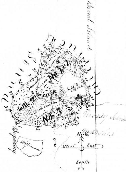
11-12 Oct 1877 - Surveyors Plat. This plat represents Brant Island of marshes surveyed the 11th & 12th of October 1877, by virtue of the annexed order of Court for the purpose of a division between the heirs of Sandford DOXEY & Thos. EVERTON or their representatives; the DOXEY heirs representing 2/3 & the EVERTON heirs the other 1/3, containing 285 acres, and in order to make Little Oyster Creek the division line as near as possible with a straight line a little more than 1/3 was added to the EVERTON side, that is to say, that the EVERTON part contains 103 acres and the DOXEY part 182 acres. The division commences between stations 34 &1, 5 chains from the former, 7 chains & 90 links from the latter in the water striking the marsh on the South side of Little Oyster Creek at a post, North 65° East running across the various meanderings of said Oyster Creek, and across the big pond to the South side of the gap called Hole in the Wall 69 1/2 chains to a post, one chain from station 22, & South of it. The following are the courses and distances around said Island [a long page of metes & bounds were given] /s/ H.B. ANSELL, CSC
not dated - We, the undersigned commissioners, having been appointed by order of the Superior Court to divide and appropriate an Island of Marsh known as Brant Island among the tenants in common set forth in the petition for partition, did on the 11th & 12th day of October 1877 proceeded together with the County Surveyor and divided and set apart the same among the heirs & representatives of Sandford DOXEY, deceased, and heirs & representatives of Thomas EVERTON, deceased, according to their respective rights. The heirs of Sandford DOXEY are allotted all the Northwest part of said Island with a line of partition drawn from the south side of the West mouth of Little Oyster Creek on the west side of the Island, thence cutting across the meanderings of said Creek and across the Big Cove to Hole in the Wall on the east side of the Island--this part represents 2/3 in value and covers 182 acres. For courses and distances see Surveyors Report & plat. This part on plat is markers No. 1 & No. 2.
To the heirs of Thomas EVERTON, deceased, is allotted all the South east part of said Island and as far North as the above described partition line--this covers 103 acres and 1/3 in value of said Island and is marked No. 3 on the plat. We ran the division line in that place on account of giving, as near as possible, the creek & cove as a natural dividing line. The division commences 7.90 chains Northwesterly from the beginning or the point near the west end of Williamson Island marked station No.1, and 5 chains off the most west point of marsh of said Island marked on plat No. 34 and ends on South side of Hole in the Wall and one chain from the North side of it at station No. 22. Both ends of division are marked with posts. /s/ W.H. WALKER, S.F WOODHOUSE[Source: Currituck County Record of Estates 1812-1926; Vol. Brumsey-Ferebee (Microfilm G.030.1862909)]
This estate was contributed by Kay Midgett Sheppard. No part of this document may be used for any commercial purposes. However, please feel free to copy any of this material for your own personal use and family research. If you find anything in these records that pertains to your families, it is strongly suggested that you look at the original record on your own to check for errors or possibly other additional and helpful information. Thank you!
© 2007 Kay Midgett Sheppard