
Return to Currituck Co.
![]()
[Deed Book 23; pg. 28] May 27, 1840 - Samuel THOMPSON of Currituck Co. sold to Doxey LEE of Chowan Co., for $50.00, a tract of land whereon my father Samuel THOMPSON, dec'd., lived and died in Currituck County Court House District bound by the Main Road on Northeast, John BELL on the Northwest & Southwest, and by Edmund BAXTER on Southeast containing 30 acres. Witnesses: E. SIMMONS, B.T. SIMMONS. Registered: Sept. 21, 1840
[Deed Book 23; pgs. 29-30] Oct. 18, 1837 - Robert J. WILLIAMS sold to Jonathan WOODHOUSE, both of Currituck County, for $850.00, a certain piece or parcel of land bounded as follows….WILLIAMS side of East Swamp in Thomas SANDERSON a Northerdly course binding on the East Swamp side to Cason MORRISETT line, westerly binding on MORRISETTs line, then road side to west side of William NICHOLSONs in Patent granted to Peter POYNER South End of patent at Thomas SANDERSON line , Easterly binding on Thomas SANDERSONs line, containing 120 acres. Witnesses: Thos. B. JARVIS, William A. JARVIS. Registered: Sept. 21, 1840.
[Deed Book 23; pgs. 30-31] July 15, 1840 - Frederick PERRY sold to Thomas TWIFORD, for $85.00, a certain piece of land on the North Banks , beginning at the Sandy Run Bridge….to Kitty Hawk Bay…..Elijah SEBBRENs run the shore to a gut, binding Joshua HARRISON the west, Elijah SEBBRENs the north…to contain 75 acres more or less. Witnesses: Sol. ASHBEE, Ivy DOWDY. Registered: Sept. 21, 1840.
[Deed Book 23; pgs. 31-32] Nov. 27, 1839 - Caleb S. WALKER of Tyrel County sold to Samuel B. DOZIER of Currituck Co., for $400.00, a piece of land being in Currituck, bounded as follows: North by Arm SIMMONS, East by Levi WALKER, South by Elizabeth GRAY, containing 128 acres. Witnesses: Caleb ELVERTON, Levi WLAKER. Registered: Sept. 21, 1840.
[Deed Book 23; pgs. 32-33] May 23, 1840 - John ETHERIDGE of the County of Desota & State of Mississippi, sold to Josiah ETHERIDGE, for $50.00, a certain parcel of land in Currituck known by the name of Juniper Ridge, it being 14th part of land formerly belonging to William HUMPHRIES sold by his Executor and bid off by Josiah ETHERIDGE, and which John HUMPHRIES gave a deed to Josiah ETHERIDGE for 193 acres. Witness: William ETHERIDGE. Registered: Sept. 21, 1840.
[Deed Book 23; pgs. 33-35] Jan. 4, 1840 - Isaac N. BAXTER, Guardian of Isaac N. HUGHS and Mary B. HUGHS, orphans of John W. HUGHS, dec'd.,.sold to CALEB ETHERIDGE, by virtue of an order of Court of Pleas and Quarter Sessions, lands of John W. HUGHS which were advertised for sale at Court House done on 4th day January 1840 for the purpose of paying a judgment in favor of Jonathan B. LINDSEY against the heirs of said HUGHS. Caleb ETHERIDGE SR. offered bid of $700.00. Said land in Court House District bounded as follows: tract where said HUGHS formerly lived beginning in the road Cart BELL and EDWARD HALSTEAD corner, various courses with road to Samuel KEMP corner, from KEMPs line to corner in Wm. F. DAVIS heirs land, south to James SNOWDENs heirs line various courses to Buckskin road east various courses of the road to first station containing 114 acres. Another piece lying on South and West of Buckskin road the tract that C.R. KENNEY sold as Executor of W.F. DAVIS beginning at Buckskin road formerly Wm. PERKINS line binding said line to Joshua BAXTERs line, containing 38 acres. Another piece adjoining this piece willed to John W. HUGHS by John WILLIAMS, at a corner then HOLLEYs various courses to Joshua BAXTERs line various courses to William POYNERs line to William PERKINS formerly John PERKINS line containing 26 acres, making in all 1781/4 acres more or less. Witness: W.B.F. BAXTER. Registered: Sept. 21, 1840
[Deed Book 23; pgs. 35-36] July 1, 1839 - Ida WICKER sold to William WHITE, for $5.00, a certain piece of land lying on Knots Island which land fell to me by the death of my Father Wm. WICKER adjoining lands of Jacob WICKER, Malachi WATERFIELD and William WHITE. Witnesses: Nath. W. DOUDLY, Bragwell MOORE. Registered: Sept. 21, 1840.
[Deed Book 23; pgs. 36-37] Jan. 14, 1840 - Edward GARRETT sold to Duren E. GARRETT, for $20.00, a parcel of land in a place called Back Woods …Moses B, POWERS line formerly called SPENCERs line, down to John L.D. POWERS, dec'd.,. containing 18 acres. Witnesses: George W. POWERS, James SORY. Registered: Sept. 21, 1840.
[Deed Book 23; pgs. 37-38] July 27, 1840 - Tully DOZIER, SR. sold to Henry William LEE, for $450.00, a parcel of land in Indian Ridge District near Guinea, bounded by Widow FLOROREYs land on main road twenty feet from the canal to Branson BELL along BELLs line of Cypress Run or branch, continues along various courses within twenty feet of Canal by estimation of 48 acres. /s/ Tully DAUGE. Witnesses: Benj. N. BRAY, Tully L. DOZIER. Registered: Sept. 21, 1840.
[Deed Book 23; pg. 38] May 27, 1840 - Wallace BRAY sold to Doxey LEE of Chowan County, for $175.00, a parcel of land where Samuel THOMPSON, dec'd., lived. Bounded by John BELL on the Northwest & South tract and Edward BAXTER on Southeast, also a tract of land whereon Saml. THOMPSON JR. lives binding James DOXEY on the North & South John MATTHIAS on West & East of main road, containing 30 acres. Both my right & title to the said lands and the right & title I bought of Edmund THOMPSON, heir of Samuel THOMPSON, dec'd., and the widows dower of the said deceased. Witnesses: E. SIMMONS, B.T. SIMMONS. Registered: Sept. 21, 1840.
[Deed Book 23; pgs. 39-40] Sept. 26, 1840 - Joseph LEARRY & Wife Harriett B. LEARRY, Jermima VanPELT & Henry VanPELT, sold to Josiah HOLLEY of Bertie County, for $500.00, parcel of land in Currituck known as Jackson Island being in Roanoke Marshes, the Island upon which the General Government built a “Lighthouse” sued for and recovered by the heirs at Law of Daniel VanPELT late of Hertford County including the whole of said Island. Witness: Wm. W. CHERRY. Registered: May 4, 1841.
[Deed Book 23; pg. 48] July 25, 1840 - John M. MIDGETT sold to the United States, for $40.00, "...my share, being 1/5 of 4 acres of land lying on Body's Island..." joining the south prong of Deep Creek, it being the land designated by Capt. SKINNER as the site for a lighthouse. Witnesses: Isaac L. FARROW, Thos. H. BLOUNT. /s/ John M. MIDGETT. Registered: June 2, 1841.
[Deed Book 23; pg. 58]
September 25, 1840 - I Michael WHITSON for and in consideration of the
sum of $46.75 paid to me by Elihue WOODHOUSE for a parcel of land & swamp
that fell to me by the death of my Father Michael WHITSON commencing at a
pine on the side of main road at Elihu WOODHOUSE land along WOODHOUSE
land thence eastward course to back line to land formerly belonging to
Malachi MERSER various course to land of Elihu WOODHOUSE which is
called the MERCER land various courses to first station to contain 200
acres. Witness: George WILTBENAGER. Registered December 13,
1840
[Deed Book 23; pg. 59]
July 27, 1840 - I Henry W. LEE for and in consideration of the sum of
$700.00 paid to me by Tully DOZIER SEN. for a parcel of land binding
Joab DOZIERs thence along the line to Lazareth FLORYs line to first
station to contain 50 acres. Witness: Tully L. DOZIER, Benj. N. BRAY.
Registered December 13, 1840
[Deed Book 23; pg. 59-60] October 6, 1838 - We James ETHERIDGE and wife Elizabeth for and in consideration of the sum of $35.00 paid to us by William DOWDY for a tract of land known by name of MULDEN tract containing 20 acres. Beginning at John FANSHAW & James COWELLs corner and running a Eastward course binding on said COWELLs land to William MACKBRIDEs line thence Eastward course to creek binding on the said William MACKBRIDEs line thence various courses of the creek to John FANSHAWs line to the first station. Witness: D.B. MORSE, Joshua FENTRESS. February term 1840 - Elizabeth ETHERIDGE appears and acknowledges she signed deed of her own free will and consent. Witness: C. ETHERIDGE, Ja. BELL. Registered December 13, 1840
[Deed Book 23; pg. 60-61]
September 29, 1840 - I Josiah IVES for and in consideration of the sum of
$425.00 paid to me by Dennis W. DUNTON for a parcel of land beginning at
a post at Ephram BALLANCEs corner running Eastwardly course binding said
BALLANCEs line to the sound then along the sound to Ann Matildy
LINDSEYs line to the main road thence along main road to first station
containing 50 acres. Witness: Josiah JONES, Betsey McHORNEY.
Registered December 13, 1840.
[Deed Book 23; pg. 110-111]
I William DUDLEY for and in consideration of the sum of $32.50 paid to me
by Ezekiel BEASLY for a certain tract of land lying on Knotts Island
commencing at S.E. corner post adjoining the land of said BESELY thence
running a Westwardly course to Wm. SMITHs line thence down his line to a
post to the land of Lydia WATERFIELDs on the North side thence a
Eastwardly course binding on said WATERFIELDs line to the land of
James J. SPRATT from his line to first station containing 2 acres.
Witness: John J. WATERFIELD. Registered March 15, 1841
[Deed Book 23; pg. 110-111] April 18, 1839 - I Wilson G. NASH guardian to the heirs of Joseph BALLENTINE agreeable to an order of Court November term 1838 for and in consideration of the sum of $691.00 paid to me by Jesse B. LEE for a negro boy named Harry. Witness: Johnston MARCHANT. Registered March 15, 1841
[Deed Book 23; pg. 111-112] November 25, 1840 - I Hugh WILLIAMSON for and in consideration of the sum of $100.00s paid to me by John FORBES for Two certain parcels of land in District of Coinjock. One tract beginning at land owned by Alex. SPEERS running Westly by land owned by William ONEALs estate Southerdly by land of Samuel ONEAL and thence to first station containing 14 acres. The other tract commencing bounded on the East by lands of Samuel ONEAL running Westerdly to land formerly owned by Moses CRICKMORE and containing 10 acres. Witness: E. SIMMONS, John JARVIS, JUN. Registered March 15, 1841
[Deed Book 23; pg. 112-113] November 12, 1840 - Indenture made between James M. FEREBEE and Elenor HUMPHRIES, witnesseth whereas Josiah ETHERIDGE late of Currituck died Testate as a certain piece of land beginning in West corner of Tully L. DOZIERs line various courses to first station containing 193 acres, which said tract the said Elenor HUMPHRIES and daughter of Josiah ETHERIDGE dec’d. now for and in consideration of the sum of $200.00 paid to said HUMPHRIES by James M. FEREBEE doth convey unto him all her undivided interest and share in above tract of land known by name of Juniper Ridge. Witness Benj. BRAY. Registered March 15, 1841
[Deed Book 23; pg. 113-114] January 12, 1841 - Between Terance WALLER of first part, William JONES who is naturally chosen trustee to the second part, and Wilson CORPREW of the County of Norfolk and State of Virginia of the third part. Whereas said Terance WALLER is and stands justly indebted to the said Wilson CORPREW the several sums of money due by notes to wit. One note for $150.00 dated May 1, 1840, two years after date with interest from date. One other note for $84.97 due January 2, 1841 and in order to secure the payment of the same hath consecuted and agreed to make over in trust the following property herein after described. Now this indenture witnesseth that the said Terance WALLER for and in consideration of the sum of $1.00 to him paid by William JONES upon Trust to wit One tract of land which I purchased from James PARSONS lying in the district of Moyock and bounded on the lands of James PARSONS the heirs of Nicholas SLACK dec’d the Shingle Land Creek and other persons containing 100 acres. Also one other tract being in afsd. District and binding on the above tract of land John N. WILSON & others containing 30 acres. Also all my horses, cattle, hogs, sheep, corn fodder household and kitchen furniture all and every species of property in my possession. To have and to hold the within named property unto the said William JONES upon Trust witnesseth if said Terance WALLER shall well and truly pay or cause to be paid unto William Wilson CORPREW the within named debt with the cost and charges occuring before the First day of May 1842 then this indenture to be of no affect. But should the said WALLER fail to pay to CORPREW the above named amounts for the said William JONES may after 10 days notice for time and place of sell and convey the same to the purchaser and out of proceeds to pay within named debts with interest cost and charges & the surpluss if any to pay over to the said WALLER. Witness: Thos. B. BUTT. Registered March 8, 1841
[Deed Book 23; pg. 115] February 22, 1841 - Between Jordan HUMPHRIES and wife Elizabeth of State of Virginia and County of Princess Anne and Caleb CAPPS of Currituck for and in consideration of the sum of $105.00 paid to me Jordan HUMPHRIES and wife Elizabeth by Caleb CAPPS for a certain parcel of undivided land lying on Knotts Island bounded on North by the lands of the heirs of William CAPPS dec’d and on the East by the waters the land of Dennis CAPPS heirs dec’d by the South and on the West by the main road together with a right in the woodling that Joel CAPPS dec’d gave to his Son Joel which fell to the said Elizabeth HUMPHRIES. Witness: John J. WATERFIELD. February Term 1841- Elizabeth HUMPHRIES appeared before James BELL, & James M. FEREBEE Esquires and she acknowledges she signed deed with her own free will and accord. This February 22, 1841. Registered March 15, 1841
[Deed Book 23; pg. 116] February 3, 1841 - I John CATON for and in consideration of the sum of $260.00 paid to me by James M. FEREBEE for a parcel of land and swamp being known by name of Goard Ridge bounded beginning at a cypress at James COWELLs line then East course with said James M. FEREBEEs line across the ridge to James BELLs line thence with the said BELLs line Northerly to William SNOWDENs and BELLs corner in Goard Ridge branch thence with SNOWDENs line a south course to James COWELL line to the first station containing 17 acres. Witness: R.M. BERRY. Registered March 15, 1841
[Deed Book 23; pg. 117] January 12, 1841 - I Sally ONEAL for and in consideration of the sum of $20.00 paid to me by William WOODHOUSE for a certain parcel of land lying on the main Powells Point road beginning at main road thence Northerly course along said road to Julia WOODHOUSE line various courses to Thomas WHITEHALL line along WHITEHALL line to main road containing Two and a half acres. Witness: C.T. CHAPLAIN. Registered June 15, 1841
[Deed Book 23; pg. 117-118] May 31, 1841 - I William BALL for and in consideration of the sum of $1000.00 paid to me by Wilson R. SUTTON for a parcel of land that Nancy GRAY bought of Daniel LINDSEY lying on Churches Island beginning at a post on the sound thence Southardly binding said sound to John W. GRAYs line thence Westwardly binding said GRAYs line to Coinjock Bay thence Northwardly binding said Bay to Enoch BALLs line thence Eastwardly with line to the sound then with the sound to the first station containing 200 acres. Also all Nancy GRAYs right of Dower to the lands on Churches Island descended from her husband Thomas GRAY deceased. The said Wm. BALL doth covenant that he is seized of said Leases in fee simple that he hath good title for Nancy GRAYs life to said dower right and can lawfully convey the land etc. Witness: J. FORBES, Thos. TWIFORD. Registered June 15, 1841
[Deed Book 23; pg. 118-119] April 13, 1839 - Wilson G. NASH guardian to the heirs of Joseph BALLENTINE dec’d agreeable to an order of Court November term 1838 for and in consideration of the sum of $791.00 to me paid by Jesse B. LEE for one negro boy named Lamb. Witness: Johnston MARCHANT. Registered March 15, 1841
[Deed Book 23; pg. 119-120] February 22, 1841 - I William M. GREGORY for and in consideration of the sum of $20.00 to me paid by Jesse HOBBS for one certain piece of land being on North side of beginning at Jesse HOBBS a Northerly course along the sound side to OUTLAWs line various other courses to first station containing 18 acres. Witness: Sol. ASHBEE, W. L. HARRISON
[Deed Book 23; pg. 120-121] September 16, 1840 - I John BARNARD for and in consideration of the sum of $1350.00 paid to me by Nathan BARNARD for a certain tract of land being the land formerly belonged to Jessey BARNARD dec’d bounded commencing at main road on North side of the Big Ditch on canal adjoining the land belonging to Daniel SANDERSON and Wife and from main road running Northerly and an Eastwerdly course binding the lands of D. SANDERSON to the North Corner to the land of Edmond LINDSEY then Eastwerdly and Southerdly corner binding lands of Edmond LINDSEY and Thos. S. SANDERSON to the Swamp road a South Westerdly course binding the land of Wilson CORPREW and Wife various courses along Swamp road to first station containing 250 acres. Witness John FANSHAW, E. W. WOODHOUSE
[Deed Book 23; pg. 121-122] December 19, 1838 - I Joseph OWENS for and in consideration of the sum of $200.00 paid to me by Samuel OWENS for a parcel of land lying on Powells Point adjoining the land of James OWENS & others beginning at a pine post at the corner of James OWENS thence easterly with James OWENS land thence along Southerly to David OLDS line various courses to first station containing 55 acres. Witness: Dorcas STACY, Young OLDS.
[Deed Book 23; pg. 122-123] January 10, 1842 - Between CalebW. WILLIAMS of the first part, Jno. C. HETFIELD of the second part & J.R. BRIGHT Trustee of the third part, whereas the said Caleb W. WILLIAMS is justly indebted to John C. HETFIELD in the sum of $800.00 by note bearing date January 10, 1842 and whereas the sd. Caleb W. WILLIAMS being desirous to secure the payment of sd. Debt now therefore this indenture. Witnesseth for and in consideration of the premises together with the further consideration of the sum of $1.00 in hand paid to the sd. Caleb W. WILLIAMS by the said J.R. BRIGHT Trustee for 3 negroes viz. Jacob aged 60 years, Henry aged 55 & Daniel 35. J.R. BRIGHT his heirs etc. in fee simple forever in special trust & confidence shall apply the same to the use intent following & no other that is to say that if the aforesaid debt together with the lawful interest that may have accrued on the same shall not be fully paid off on or before January 10, 1845 then and in that case it shall be lawful & shall be the duty of the sd. J.R. BRIGHT being hereby required by the sd. John C. HETFIELD having first advertised the same at the Court House of sd. County and 3 other public places within County for space of 20 days to proceed & sell the said property at public auction to highest bidder for ready money & convey the same by proper & sufficient ??????? The purchaser & out of the proceeds or moneys arising from sd. Sale to detain all the necessary expenses of this Trust & then pay off & discharge the sd. Debt & interest or such part thereof as shall remain unpaid at the time of sd. Sale & the overplus (if any) he shall truly & faithfully return to the said Caleb W. WILLIAMS his Extrs. Etc. & it is further agreed by & between the parties to these presents that in the mean time that is to say from the date hereof until the day of sale the said Caleb W. WILLIAMS shall be privileged & entitled to hold said property & use & apply the profits to his use & benefit & if at any time before the sale of the property the said Caleb W. WILLIAMS shall pay off & discharge the aforesaid debt & interest together with all necessary expenses hereby incured then in that case this indenture & every part & clause thereof shall be utterly void & of no effect otherwise to remain in full force. Witness: John S. WILLIAMS
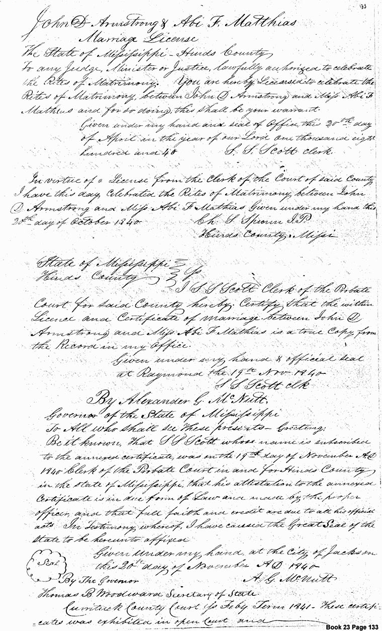
[Deed Book 23; pg. 133-134] Marriage license between John D. ARMSTRONG & Abi F. MATTHIAS in Hinds Co., Mississippi. To any Judge, Minister or Justice lawfully authorized to celebrate the Rites of Matrimony. You are here by Licensed to celebrate the Rites of Matrimony between John D. ARMSTRONG and Miss Abi F. MATHIAS and for so doing this shall be your warrant. In Virtue of a License from the Clerk of the Court of said County I have this day celebrated the Rites of Matrimony between John D. ARMSTRONG and Miss Abi F. MATHIAS given under my hand this 20th day of October 1840. /s/ Ch. S. SPENCER, J.P. [MARRIAGE RECORD - see image]
State of Mississippi
Hinds County
I,
S.S. SCOTT Clerk of the Probate Court for siad County
hereby Certify that the within License and Certificate of marriage between
John D. ARMSTRONG and Miss Abi F. MATHIAS is a true copy from the
Record in my office. Given under my hand & official seal at Raymond the 19th
Nov. 1840.
By Alexander G. McNUTT Governor of the State of Mississippi
To All who shall see these presents—Greeting: Be it known
that S.S. SCOTT whose name is subscribed to the annexed certificate was on the
19th of November A.D. 1840 clerk of the Probate Court in and for
Hinds County in the State of Mississippi that his attestation to the annexed
certificate is in due form of Law and made by the proper officer, and that full
faith and credit are due to all his official acts. In testimony whereof I have
caused the Great Seal of the state to be hereunto affixed. Given under my hand at the city of Jackson this 20th
day of November A.D. 1840. /s? A.G. McNUTT
Thomas B. WOODWARD, Secretary of State
Currituck
County Court SS - Feby Term 1841 These certificates was exhibited in open Court.
Registered: March 15, 1841
[Deed Book 23; pg. 136-137] I Jesse B. LEE for and in consideration of the sum of $791.00 paid to me by Wilson G. NASH for one negro boy named Lemuel. Witness: Johnston MARCHANT. Registered March 15, 1841
[Deed Book 23; pg. 137] December 8, 1840, - I John SMITH for and in consideration of the sum of $50.00 to me paid by John C. HETFIELD for a parcel of Beach and Marsh land the one half of the said tract that I bought of Dennis TATUM as pr. deed May 9, 1837, beginning at South side of Currituck Inlet it being part of the beach & marsh of land included in John WHITEHEADs patent know by the name of Sassefras Marshes containing50 acres. Witness: Jas. WILLIAMS, Edward HALSTEAD. Registered March 15, 1841
[Deed Book 23; pg. 156] No. 695 - Know all men present that we for and in consideration of the sum of $10.00 for every 100 acres paid into our Treasury by Henry WHITE, David JONES, Levin WHITEHOUSE & Lydia HARDY for a tract of land containing 158 acres in Knotts Island known by the name of Jesse Nole, Abbeys and Long Nole beginning at an angle of Indian Creek and a ditch across Whites Nole various courses to first station. Entered October 9, 1840. By Command W. HILL Secretary of State. Registered December 5, 1841
[Deed Book 23; pg. 157] I Edward H. BAXTER for and in consideration of the sum of $1000 dollars paid to me by William F. BAXTER for a tract of land in the Court House district, binding on the south by the lands belonging to the heirs of Edward HARDY deceased, on the East by Currituck Sound containing 114 acres. Witness: S.B. DOZIER, J.W. BAXTER. Registered June 13, 1841
[Deed Book 23; pg. 169] January 6, 1841 - William MURRILL sold to Samuel PARKER for $30.00, for a certain piece or tract of land containing 2 acres running down Spence HALL’s line a S.W. coarse and various other courses. Witnesses: Manliff R. GREGORY, Polly PARKER. Registered: June 13, 1841.
[Deed Book 23; pg. 169-170] February 22, 1841 - Tully BELL, Clerk & Master to Hodges GALLOP. Whereas at Fall Term 1839 William WALKER, Levi WALKER, Caleb WALKER, Lovey WESTFIELD, Naomi WALKER of full age and of Polly WALKER & Nancy WALKER, infants by their Guardian Caleb WALKER, Delia WALKER, an infant by her Father and next friend Isaac WALKER, filed their petition to sell the lands set forth in this said petition one of which tracts is situated on Powells Point adjoining the lands of Willis GALLOP and Thomas TILLETT containing by estimation 33 acres by virtue of this decree in the case it was offered for sale at auction on the premises on the 22nd day of February 1840 when and where Hodges GALLOP appeared and bid the sum of $300.00 which was the greatest and best bid it was therefore stricken off to him at that sum. He entered into bonds agreeable to the terms of sale, at Spring Term 1840 report made and confirmed at Fall Term 1840 ordered that the Clerk & Master collect the money & make a Deed to the purchasers.
[Deed Book 23; pg. 198-199] Samuel M. MANN of Hyde County sold to Benjamin MIDGETT of Tyrrell County, for $50.00, "...my right, title, and interest to the lands that descended to me from my grandfather John MIDGETT and also the land that descended to my from my uncle, Samuel MIDGETT, dec'd.", said undivided land being in Currituck County on Roanoak and Bodies Island, except 4 acres sold to the United States for a lighthouse. This indenture was made October 30, 1841. Wit: John S. BURRUS, Benj. SAUNDERSON. /s/ Samuel M. MANN. Registered: May 9, 1842.
![]()
No part of these deed abstracts may be used for any commercial purposes. However, please feel free to copy any of this material for your own personal use and family research. If you find anything in these deeds that pertains to your families, I would strongly suggest that you either order a copy of the deed from the county or look at a copy of the microfilm on your own to check for errors or possibly other additional and helpful information.
|
|
|
|
|
|
|
|
© 2012

