
Return to Currituck Co.
![]()
[Deed Book 9; pg. 1] Nov. 25, 1804 - John SIMMONS and wife Sally of Princess Anne Co., VA sold to Dennis SIMMONS of Currituck Co., for $500, 40 acres on Knots Island in Currituck. Witnesses, Jesse TAYLOR, Jno.(?) ANSELL; Registered 18 Feb 1805
[Deed Book 9; pg. 1-2] Nov. 9, 1804 - I Hillary MORSE for the sum of Ł50 paid to me by Francis MORSE for a parcel of land. Beginning at a Ditch at the corner of my Plantation to Zachariah MORSEs line along his line to contain 10 acres. Witness Zachariah MORSE, Elizabeth MORSE, Thomas MORSE; Registered Feb. 18, 1805
[Deed Book 9; pg. 2-3] Sept. 2, 1804 - I Willoughby WHITE for the sum of 135 Silver dollars paid to me by John MACKIE for a parcel of land containing 3 acres lying on Mackies Island. Beginning binding on Evan JONES line & John MORSEs line it being part of a tract that James WHITE bought of David JONES. Witness T. BAXTER, John SCURR; Registered Feb. 19, 1805
[Deed Book 9; pg. 3-4]
This Indenture made the 10th Day of November Eighteen hundred &
four Between George GRIGGS & Charlotte his wife of the county of Currituck and
state of North Carolina of the one part and Willoughby MORSE of the county and
state afsd. of the other part Witnesseth that for and in consideration of the
sum of two hundred Dollars current money in hand paid by the said Willoughby
MORSE to the sd. George GRIGGS & Charlotte his wife the Receipt whereof he
doth hereby acknowledge & therefore doth aquit and discharge the said Willoughby MORSE and his heirs a certain tract or parcel of land containing
eight acres more or less lying near the back Bay and Bordered as follows
Beginning at a pine stump a corner stump running southeastardly to a water
oake continuing ____ to John MORSE line thence binding on the sd. MORSEs land
to the great marsh cross over and thence binding on the land of Solomon MORSE, Arthur MORSE & the sd. Willoughby MORSE to a pine stump Beginning first
station on To have and to hold the said tract & parcel of land to the sd. Willoughby MORSE his heirs & assigns forever with all the appurtenances
presents Belonging or in any wise appertaining to the only proper use & Behoof
of him the said Willoughby MORSE his heirs and assigns for warrant and the
said George GRIGGS & Charlotte his wife Doth first themselves & their heirs
warrant and forever defend the tract and parcel of land unto them Willoughby MORSE his heirs and assigns forever ____ themselves the sd. George GRIGGS & Charlotte his wife and his heirs and all persons whatsoever, in Witness
whereof I the sd. and George GRIGGS & wife hath hereunto set our hands & seals
the same date as first written. /s/ George [his x mark] GRIGGS;
Charlotte [her x Mark] GRIGGS. Witness. Test John
[his x mark) MORSE; John CARSON; Caleb BURKETT
State of N. Carolina Currituck __Novem. Term 1804. This Deed of Sale from George GRIGGS & Charlotte his wife to Willo. MORSE was proved by the oath of John CARSON in open Court in due form of Law & ordered Registered According to
order is Registered Feb of the 19th Day 1805. Test Willis
ETHERIDGE Pub. Register; Attest T. BAXTER C.C.C.
[Submitted by
Jean Schroeder]
[Deed Book 9; pg. 4-5]
This Indenture made twentieth fourth day of
November in the year of our Lord one Thousand Eight hundred & four Between
John MORSE of the one part of the County Currituck and State of North
Carolina and George GRIGGS of said County and State of the other part
Witnesseth that for and in consideration of the sum of two hundred and fifty
Dollars in hand paid I the said George GRIGGS the said John MORSE
the Receipt whereof he Doth hereby acknowledge and therefore Doth aquit and
discharge George GRIGGS and his heirs & have granted Bargained & Sold and
by these presents Do grant Bargain Bargain Sell and Deliver unto the sd.
George GRIGGS and his heirs a certain tract or parcel of land containing
twenty five acres and Bounded as follows Beginning at a Gum standing near the
new Ditch South forty five & Degrees west to a Gum stump joining Uriah CASONs
land to a point joining Wm. JONES land joining Wm. JONES land to a
corner Gum then Beining at the first Station at a Gum running from thence then
Runing South fifty four and half Do East to a corner Gum to have and to hold the
said tract and parcel of land to the said George GRIGGS & his heirs and
assigns forever with all the appurtenances presents Belonging or in any wise
appertaining to the only proper use and Behoof of him the sd. George GRIGGS
his heirs and assigns forever & the sd. John MORSE Doth for himself and
his heirs warrant and forever Defend this sd. Tract & parcel of land unto the
said George GRIGGS and his heirs & assigns forever against himselfe the
said John MORSE and his heirs and all persons or persons whatsoever in
Witness whereof I the sd. John MORSE hath hereunto set my hand & seal the
Day & Year first Written. Signed Sealed & Delivered in presence of Caleb
BURKETT, Arthur MORSE & John GRIGGS. /s/ John
[his x mark] MORSE
State of N. Carolina Currituck Js: Novem. Term 1804. this Deed of Sale from John
MORSE to George GRIGGS was proved by the oath of Arthur MORSE & John GRIGGS in
open court in due form of law & ordered Registered. Attest T.
BAXTER C.C.C.
According to order is Registered Feby the 9th day of 1805.
Test Willis ETHERIDGE Pub. Register
[Submitted by
Jean Schroeder]
[Deed Book 9; pg. 5-6]
This Indenture made the 27th Day of
Novemb. One thousand Eight hundred and four Between John SIMMONS &
Sally his wife of the county of Princess anne and State of Virginia of the
one part & Robert SIMMONS of the County of Currituck No. Carolina of the
other part Witness that for and in consideration of the sum of five hundred
dollars to the said John SIMMONS and Sally his wife in hand paid
by the said Robert SIMMONS at & Before the Sealing and Delivery of these
presents the Recipt whereof we Do hereby acknowledge and thereof and every part
thereof Do hereby acquit Exonerate and Discharge the said Robert SIMMONS
his heirs and assigns by these presents they the sd. John SIMMONS &
Sally his wife have Granted Bargained Sold alined and confirmed unto the sd. Robert SIMMONS his heirs & assigns one certain tract or parcel of land
containing forty acres situate lying on Knots Island in the County of Currituck
being part of the tract of land formerly the property of John SIMMONS
Decd. And Bounded as Follows viz & Beginning at the Creek on the Eastward side
of said land and running by a line of marked trees S:881/2 W to the Great Marsh
S:67 W. Bordering on Marsh then N.881/2 D ; E: to sd. Creek then along sd. Creek
to the first Station. To have and to hold the sd. Bargained premises with all
the appurtenance thereunto Belonging to the sd. Robert SIMMONS his heirs
& assigns forever to his and their proper use and Behoof and the sd. John
SIMMONS & Sally his wife Do hereby covenant and promise that the sd.
Land is free from every incumbrance whatsoever had made Done committed or
suffered by them & the sd. John SIMMONS and Sally his wife fore
themselves their heirs Execr. and Admr. This Bargained premises unto the sd.
Robert SIMMONS his heirs & assigns forever will warrant and Defend against
all & every person or persons whatsoever laying claim or claimes thereunto,
Witness whereof the sd. John SIMMONS and Sally his wife have
hereunto set their hand & Seals the day & year first above Written & Signed
Sealed & Delivered in the presents of us Witnesses. Test Jesse TAYLOR, John
ANSELL; /s/ John SIMMONS
State of N.Carolina Currituck Js. Novem. Term 1804.. This Deed of Sale from John SIMMONS to Robert
SIMMONS was acknowledged in open Court in due form of Law Ordered Registered
According to order is Registered Feb the 19th Day of 1805.
Attest. T. BAXTER C.C.C.
Test Willis ETHERIDGE Pub. Register
[Submitted by
Jean Schroeder]
[Deed Book 9; pg. 6-7] 1803 - I Caleb ETHERIDGE Sheriff by order of a Writ of Fiere Facis issued out of the Court of Pleas & Quarter Sessions commanding me out of the goods chattles & lands of Samuel JASPER dec’d in the hands of his Exec. to cause the sum of Ł22 & 10 Shillings for debt along with the sum of Ł5, 7 Shillings & 3 Pence for cost & charges which Elias WILLIAMS lately recovered against JASPER. Secondly I was commanded to cause the sum of Ł47, 14 Shillings & 9 Pence also the sum of Ł8, 12 Shillings & 11 Pence cost & charges which was recovered by Major CLARK against the Exec. of Samuel JASPER dec’d for debt & costs. The total of these 2 judgments in the sum of Ł70, 4 Shillings & 9 Pence. In obedience of the 2 Writs I Caleb ETHERIDGE Sheriff did enter & take possession a tract of land whereon Samuel JASPER dec’d formerly lived & his Widow now lives on Knots Island, bounded by William BONNEY, Mordica BEESLEY dec’d containing 14 ˝ acres. At publick vendue on the premises where & when Malachi JONES did appear & bid the sum of Ł5 & 16 Shillings pr. acre & was highest bidder in the sum of Ł84 & 2 Shillings, therefore I have granted & conveyed unto Malachi JONES the said land. Witness T. BAXTER; Registered Feb. 20, 1805
[Deed Book 9; pg. 7-8] Oct. 28, 1804 - I Arthur NORTHERN for the sum of $125 paid to me by Henry BALLENTINE for a percel of land. Beginning in James NICHOLSON’S line various courses to Franky WILLIAMSON’S line to Caleb COX line various courses to the first containing 75 acres. Witness Jos. BALLENTINE, Simon WILSON; Registered Feb. 20, 1805
[Deed Book 9; pg. 8] Oct. 28, 1804 - I Arthur NORTHERN for the sum of $125 paid to me by Javon COX for a percel of land. Beginning in James NICHOLES line across the main road to Frankey WILLIAMSON line to a corner in Patrick NORTHERNs line binding on his line to the first containing 75 acres. Witness Jos. BALLENTINE, Simon WILSON; Registered Feb. 21, 1805
[Deed Book 9; pg. 8] Nov. 27, 1804 - I James DAUGE, JUN. for the sum of $100 paid to me by Phillip DAUGE for a peace of land in the West Swamp. Beginning in a line between Samuel FEREBEE, Phillip DAUGE, & James DAUGE to Crabs Nole that I sold James DAUGE to Samuel FEREBEE with his line to the first containing 7 acres.; Registered Feb. 21, 1805
[Deed Book 9; pg. 9] Oct. 8, 1804 - Thomas MERCER to Louis THOMPSON. Both of Currituck, for Ł20, 1 acre lying in the road side at the line between me and James PHILLIPS. Witness: Charles V. HERBERT, Louis (x-her mark) CLARKSON; Registered Feb. 21, 1805
[Deed Book 9; pg. 10-11] Nov. 26, 1804 - I Phillip DAUGE for the sum of Ł200 paid to me by James DAUGE JUN. for a tract of land. Beginning at a corner between Benjamin CHITTUM heirs & Phillip DAUGE along this line to James DAUGE corner to Crabs Nole to the roade to the first containing 18 acres.; Registered Feb. 21, 1805
[Deed Book 9; pg. 11] Feb. 21, 1696 - Know ye that we have given & granted unto Thomas COX a tract of land containing 640 acres on the South side of Moyock Creek. Beginning at a corner taken up by John BENNETT with his line to William STAFFORDs line down the Creek various courses to the first. This land being due to Thomas COX for the transportation of 1 person for every 50 acres. Yielding & paying unto us 1 Shilling for every 50 acres, provided that Thomas COX causes to seat or plant within 3 years of date hereof. /s/ John ARCHDALE; Registered Feb. 22, 1805
[Deed Book 9; pg. 11-12] Nov. 22, 1804 - I Caleb ETHERIDGE Sheriff by an order issued out of the Court of Pleas & Quarter Sessions I was ordered to sell at publick auction a negro man that calls himself Thomas WILLIAMS agreeable to Act of Assembly prohibiting the unlawful importation of Negroes, that Ľ of the purchase money be paid down the other ľ be for 6 months credit the purchaser giving notes with approved security. In obedience of this order on June 2, 1803 at publick vendue where & when James DOZIER JUN. appeared & bid the sum of Ł181 & was highest bider, by virtue of the order I Caleb ETHERIDGE Sheriff have conveyed the negro man Thomas WILLIAMS unto James DAUGE JUN. Witness T. BAXTER; Registered April 4, 1805
[Deed Book 9; pg. 12-13] Jan. 29, 1805 - We Cornelius JONES & Charlotte WHITE for the sum of $250 paid to us by Thomas BRAY for a negro woman named Sarah & her child named Linner. Witness Nancy BRAY; Registered April 4, 1805
[Deed Book 9; pg. 13] Sept. 2, 1790 - I William NORTHERN for the sum of Ł90 paid to me by Brickhouse BELL for a negro woman named Sary & child by name of Sarey. Witness Gideon MARCHANT; Registered April 4, 1805
[Deed Book 9; pg. 13] Aug. 5, 1795 - I Samuel JARVIS for the sum of Ł20 paid to me by Lydia JARVIS daughter of Colo. Thomas JARVIS for a negro garl named Hanner. Witness Thomas GREGORY; Registered April 4, 1805
[Deed Book 9; pg. 14] Jan. 21, 1805 - I William SHEPHERD for the sum of 400 Silver dollars paid to me by Brickhouse BELL for a negro man named Jack. Witness S. FEREBEE; Registered April 4, 1805
[Deed Book 9; pg. 14-15] Aug. 8, 1793 - I Lemuel SANDERSON for the sum of Ł42 & 10 Shillings paid to me by John SANDERSON Sen. for a negro garl called Ann about 5 years old. Witness Wm. WROTEN; Registered April 4, 1805
[Deed Book 9; pg. 15] Feb. 21, 1805 - I John STANDLEY & Elizabeth my Wife for the sum of 140 Silver dollars paid to me by Thomas BAXTER for 2/3 of a negro boy named Lewis near 8 years of age which 2/3 of negro boy was deeded to us by the death of William SHERGOLD, deceased. Witness Henry MACLANEN; Registered April 5, 1805
[Deed Book 9; pg. 15] Sept. 30, 1796 - I James DAUGE for the sum of Ł85 paid to me by Willoughby DAUGE for a negro garl named Sarah about 14 years of age. Witness Wm. SIMMONS, Enoch DAUGE; Registered April 5, 1805
[Deed Book 9; pg. 16] Feb. 11, 1805 - I Joseph SIMMONS for the sum of 1 ear of corn pr year to be paid to me by Jeremiah Swaine RANDOLPH for the let all that messuage of land containing 3 acres beginning at Benjamin TAYLORs corner for the term of 12 years with privilege of timber & fire wood for the term & stock of hogs & cattle to range in marsh & woods. If Jeremiah RANDOLPH should leave the premises not to be sold to any other person but to return to me. He is also to build one log house with a brick Chimney & build a corn crib & hen house & such other houses as I see fit to put on the land. We both bind ourselves to the sum of Ł500. Witness Jesse TAYLOR, John TAYLOR; Registered April 5, 1805
[Deed Book 9; pg. 16] Feb. 15, 1805 - I John HALL for the sum of $10 paid to me by Samuel GREGORY for a lease of 1 acre during his natural life whereon his house now stands & joining Mr. HARRISONs line to be laid off near in a square as it will admit. Samuel GREGORY is to have priviledge of giting rail timber, fire wood & lightwood on HALLs land adjoining the acre, at the death of GREGORY the land is to return to John HALL. Witness S. HALL; Registered April 5, 1805
[Deed Book 9; pg. 17] Feb. 8, 1805 - I Thomas MILLER appoint my trusty & loving friend John LAMB my lawful attorney for me & in my name & stead in whatever manner or means for all intents & purposes as I myself might or could doe.; Witness John DAUGE, Abner DAUGE; Registered April 5, 1805
[Deed Book 9; pg. 18] Nov. 28, 1804 - Josiah NICHOLSON appoints James NICHOLSON of County of Currituck my true and lawful attorney for me and in my name. Witness Chas. V. HERBERT, Louis (X-her mark) CLARKSON; Registered 6 Apr 1805
[Deed Book 9; pg. 18-19] June 14, 1802 - I Matthias TOLER JUN. am held & firmly bound unto Matthias TOLER SEN. in the pennal sum of Ł500. The condition of this obligation is such that whereas Matthias TOLER SEN. has given his Son Matthias TOLER JUN. a deed for the tract of land whereon TOLER SRN. now lives on Powels Point dated June 14, 1802, now if TOLER JUN. should not meddle with nor enterrupt his Father nor his Mother but suffer them to enjoy the houses & plantations where they live during their natural life unmolested by TOLER JUN. then obligation be void. Witness Levi W. HALL, Lemuel GREGORY; Registered April 6, 1805
[Deed Book 9; pg. 19] June 14, 1802 - We James TOLER & Matthias TOLER JUN. are held & firmly bound unto Matthias TOLER SEN. for the pennal sum of Ł100. The condition of this obligation is such that whereas Matthias TOLER SEN. sold to James TOLER & Matthias TOLER JUN. a tract of land lying in Tyrrel County known by name of Bodys & Matthias TOLER SEN. is to have priviledge of cutting timber on the land. They shall not debar nor hinder TOLER SEN. from cutting timber during his natural life. Witness Levi W. HALL, Lemuel GREGORY; Registered April 6, 1805
[Deed Book 9; pg. 19] Mar. 13, 1804 - I Caleb GREGORY am held & firmly bound unto John HUTCHINGS in the just sum of $500. The condition of this obligation is such that John HUTCHINGS hath delivered to Caleb GREGORY property supposed to be adequate to the support & maintenance of HUTCHINGS during his life & GREGORY is to support him in the manner he has been accustomed with diet, clothing, washing, lodging & other necessaries. Witness Joseph MORGAN, Betsey SAWYER; Registered April 6, 1805
[Deed Book 9; pg. 20] Feb, 18, 1805 - Samuel WHITEHURST, SEN. to James DAUGE, both of Currituck, 9 acres in Currituck by said WHITEHURST and DAUGE's line. (Trade as per deed below? No money mentioned.) Witness Wm. DAUGE, Gideon WHITEHURST; Registered April 6, 1805
[Deed Book 9; pg. 20] Feb. 18, 1805 - James DAUGE SEN. to Samuel WHITEHURST, 9 acres in Currituck by DAUGE and WHITEHURSTs line. Witness Wm. DAUGE, Gideon WHITEHURST; Registered April 8, 1805
[Deed Book 9; pg. 21-22] Feb. 23, 1805 - I James DAUGE SEN. for the sum of Ł25 paid to me by Gideon GREGORY for a parcel of land. Beginning at Perkins old plantation thence binding on HUTCHINGS line thence to the first containing 25 acres. Witness Saml. ETHERIDGE, Phillip DAUGE; Registered April 8, 1805
[Deed Book 9; pg. 22] Feb. 28, 1805 - I Jeremiah PERKINS for the sum of $21 paid to me by John BELL for a parcel of land where we both live containing 2 2/4 acres & 8 poles. Witness S. FEREBEE; Registered April 8, 1805
[Deed Book 9; pg. 23] Feb. 22, 1804 - I Jacob PERKINS for the sum of $370 paid to me by Samuel FEREBEE for a piece of land on the West side of Indian Ridge. Beginning in Dennis DAUGEs line along his line to the Swamp as I bought of Josiah PARR with this line to DAUGEs corner along his line to a corner of William PARRs line to James HUTCHINS along his line to the first containing 75 acres of land & swamp. It being the land that I bought of Isaiah PARR & Dennis DAUGE which he bought of Daniel PARR. Witness B.N. BELL; Registered April 8, 1805
[Deed Book 9; pg. 23] Dec. 7, 1804 - I Richard BRUNT for the sum of Ł300 paid to me by Caleb BELL for a parcel of land, Beginning on the back of Tulls Creek at the corner of Thomas BRUNTs land along his line to Daniel LEEs land along his line to Sukey BRUNTs land to William FLORAs land along his line to Tulls Creek down the Creek to the first containing 114 acres. Witness Andrew BATES, Benjamin BRICKHOUSE, James BRUNT
[Deed Book 9; pg. 24-25] Aug. 5, 1803 - We John HUMPHRIES & Patsy his Wife, Charles GRICE & Sally his Wife of Pasquotank County for the sum of Ł20 paid to us by Samuel ETHERIDGE for a parcel of land. Beginning at Phillip DAUGEs line thence to the swamp to ETHERIDGEs line to main road along the road to the first containing 2 acres. Witness Wm. DAUGE; Registered April 9, 1805
[Deed Book 9; pg. 25] Sept. 10, 1804 - I William LINDSEY of Pasquotank County for the sum of $250 paid to me by Daniel DUNTON for a parcel of land in Currituck County & distinquished by the tract my Father give me in his Last Will & Testament. Witness Timothy CATTER, Hannah CATTER; Registered April 9, 1805
[Deed Book 9; pg. 25-26] Mar. 13, 1804 - I John HUTCHINGS for the sum of $500 paid to me by Caleb GREGORY for a parcel of land. Beginning at a corner between GREGORY & HUTCHINGS binding Nathaniel HUTCHINGS line then binding on the land of John LAMB & Peter DAUGE binding on the land of James HUTCHINGS to the first containing 50 acres. Witness Joseph MORGAN, Betsey SAWYER; Registered April 9, 1805
[Deed Book 9; pg. 26] Nov. 13, 1804 - I Thomas FEREBEE for the sum of 500 Silver dollars paid to me by William WHEATLEY for a parcel of land. Beginning at the Creek at Daniel KINNUNs line to Phillip LUFMANs CORNER along his line to William CREEFs orphans line along his line to Willoughby WHITEs corner along his line to Enoch PAINEs corner along his line to the Creek up the Creek to the first containing 100 acres. Witness Davis FANSHER, William FULFORD; Registered April 9, 1805
[Deed Book 9; pg. 27] Feb. 11, 1805 - I James ETHERIDGE for the sum of $1500 paid to me by Josiah ETHERIDGE for a tenement of land whereon I now live. Beginning at a corner between Branson BELL, James ETHERIDGE & Josiah ETHERIDGE various courses to a line between Archelus TURTEN orphans line & James ETHERIDGE & Josiah ETHERIDGE various courses to a line between Branson BELL & James ETHERIDGE to the first containing 80 acres. Witness Wm. SIMMONS, Caleb SEARS; Registered April 10, 1805
[Deed Book 9; pg. 28] Feb. 11, 1805 - I James ETHERIDGE for the sum of $100 paid to me by Josiah ETHEREIDGE for a tenement of land. Beginning at a corner in the West Swamp between James ETHERIDGE & Josiah ETHERIDGE to William SIMMONS entry down his line to a corner between Samuel DAUGE & James ETHERIDGE down this line to a line between Archelus TURTON orphans land & James ETHERIDGE then to the first containing 150 acres. Witness Wm. SIMMONS, Caleb SEARS; Registered April 10, 1805
[Deed Book 9; pg. 28-29] Feb. 22, 1804 - I Luke BARNARD & Mary my Wife for the sum of 100 Silver dollars paid to me by Thomas BAXTER for a tract of land lying on Currituck Shore. Beginning at a division line between Luke BARNARD & Willoughby MORRIS SEN. various courses to Hanson BRIGHTs corner & Richard HOLSTEADs corner near the main road leading to Tulls Creek to John GRAYs orphans corner between me & John BRYANTs orphans to John BRINTs orphans various courses binding BRYANTs orphans being Willoughby MORRIS SEN. corner & my corner various courses to the first containing 40 acres. Witness Henry MACLANEN, Susanne BERRY; Registered April 10, 1805
[Deed Book 9; pg. 29-30] Jan. 4, 1805 - I John HUMPHRIES for the sum of 400 Silver dollars paid to me by Dennis DAUGE JUN. for a parcel of land. Beginning at Keds? Run Bridge at the main road leading from the Academy various courses to the first containing 50 acres of land & swamp, it being partly the land John HUMPHRIES bought of Thomas P. WILLIAMS. Witness Willo. BARNARD; Registered April 11, 1805
[Deed Book 9; pg. 30-31] Jan. 15, 1805 - I James BRINT for the sum of $133 paid to me by Sarah BRINT for a parcel of land near the Northwest prong of Tulls Creek. Beginning at the corner between Richard BRINT & Daniel LEE along LEEs line to a corner between Daniel LEE & Thomas GLASGOW with GLASGOW line to the corner of Enoch HEATHs in GLASGOWs line along HEATHs line to Richard BRINTs along his line to the first containing 44 1/3 acres of land. Witness Zachariah MERCER, John CHITTUM; Registered April 11, 1805
[Deed Book 9; pg. 31] [date?] - Pimmons TURNER and Lucey his wife sold to Thomas HARVEY, blacksmith, all of Currituck, for 50 silver dollars, 60 acres of land in Currituck by the name of Campbell Land, formerly occupied by Solomon CAMPBELL, deceased, by Thos. MERCER, James HUGHES. Sixty acres. Witness S. THOMPSON, Robert BELL; Registered 11 Apr 1805
[Deed Book 9; pg. 32] Dec. 5, 1804 - I John BELL & Bridget my Wife for the sum of $546 paid to me by Jonathan HAILS for a piece of land in Gibb’s Woods. Beginning in Malachi REED’S line along his line to REED’S & Thomas MARCHANT’S line down MARCHANT’S to the first containing 52 acres. Witness Mitchel SIMMONS, William BELL; Registered April 11, 1805
[Deed Book 9; pg. 32-33] Feb. 9, 1805 - I Thomas MERCER JUN. for the sum of $100 paid to me by Thomas MERCER SEN. for all that tenement of land that my Father given me by Deed of Gift date Nov. 30, 1796, except 1 acre sold to Louis THOMSON. Beginning on the Sound side Colo. PHILLIPs line various courses to the first containing 70 acres. It being the land formerly bought of Caleb MASON, also one other tract of land bought of John MASON. Beginning on the Sound side Evan THOMSONs line up his line to Thomas MERCERs line of the tract of land he bought of Caleb MASON down this line to the Sound to the first containing 35 acres. Witness Solo. ALCOCK, Josiah ETHERIDGE; Registered April 12, 1805
[Deed Book 9; pg. 33-34] Sept. 19, 1804 - I Labin GREGORY for the sum of Ł400 paid to me by Benjamin MORRIS of Camden County for a peace of land on Powels Point. Beginning various courses to SIKES line binding on his line to the division line between the said parties to the high ground in LEWESEON? Various courses thence to DUKEs corner binding on his line to DOXEs? Line to a corner on ADAMS line to the first containing 217 acres. Witness E. DAILEY, James FEREBEE; Registered April 12, 1805
[Deed Book 9; pg. 34] Aug. 23, 1804 - I Anthony FENTRESS for the sum of Ł10 paid to me by David FENTRESS for a parsel of land on the North Banks on the East side of Jeanquite Creek. Beginning Josiah PERRYs with his line to Citty Hawk Ridge to the first containing 100 acres. Witness Bowin GREEN, John MACOYE; Registered April 12, 1805
[Deed Book 9; pg. 34-35] May 17, 1804 - I Samuel ETHERIDGE for the sum of Ł20 paid to me by Lemuel LANGLEY for a percel of land on Powels Point. Beginning at Albemarle Sound to Robert WEST line to the corner of Samuel ETHERIDGEs along his line various courses to the first containing 25 acres. Witness Bowin GREEN, John Macoy; Registered April 12, 1805
[Deed Book 9; pg. 35] Sept. 25, 1804 - I Lemuel LANGLEY for the sum of 300 hard Silver dollars paid to me by John ETHERIDGE for a piece of land on Powels Point on Albermarl Sound beginning at Samuel ETHERIDGEs corner down his line various courses to the first containing 25 acres. Witness Bowin GREEN, John MACOY; Registered April 12, 1805
[Deed Book 9; pg. 36] Oct. 27, 1803 - I John GIBBENS for the sum of $1000 paid to me by Jehu HALL for a parcel of land on Powels Point. Beginning on Albermarl Sound where Benjamin SIKES land runs to the Sound then with his line to Joshua GIBBENS line with his line to Caleb PADRICKs line with his line to John MELSONs land to William CHAPLINs land to Albermarle Sound various courses of the Sound to the first containing 100 acres. Witness Franky WILLIAMS, Joshua GIBBEN; Registered April 13, 1805
[Deed Book 9; pg. 36-37] Nov. 12, 1804 - I Michal WALKER for the sum of $550 paid to me by Simion SAWYER for a tract of land where on I now live. Beginning various courses to Charles DICKENS land to Henry EVANS line various courses to the first containing 80 acres. Witness Jacob SAWYER, Jesse SAWYER ; Registered April 13, 1805
[Deed Book 9; pg. 37-38] Mar. 12, 1804 - I Jacob CARTWRIGHT of Camden County, for the sum of $550 paid to me by Bowin GREEN for a parcel of land on Powels Point. Beginning on Albermarl Sound PARKERs corner with his line to HARRISONs line with his line as fer as will inclose the land that George Day WEST gave to his Daughter ANNA then agreeable to the Last Will & Testament of WEST as he ordered the land to be divided between his 2 Daughters Lusana & Anna thence to the first containing 44 acres. Witness John MACOY, Benjamin PARKER; Registered April 13, 1805
[Deed Book 9; pg. 38] Sept. 21, 1803 - I John AYDLOTT & Mary my Wife for the sum of 100 Silver dollars paid to me by Caleb FORBES for the Dower land that fell to Mary AYDLOTT at the death of her former Husband William FORBES during the Natural Life of Mary AYDLOTT belonging to her 1/3 part. Witness Zo. HARRISON, John MACOY; Registered April 15, 1805
[Deed Book 9; pg. 39] Feb. 21, 1805 - I Thomas ALLEN for the sum of Ł480 paid to me by Nathan WALKER for a parsel of land known by name of Churches Iland. Beginning at the Sound side Foster JARVESs corner binding on his line to Leven DUNTONs line with his line to the Sound binding on the Sound to the first containing 62 ˝ acres. Witness Thos. MACHONEY/MACHORNEY, John JARVIS; Registered April 15, 1805
[Deed Book 9; pg. 39-40] June 6, 1803 - I William BEST for the sum of Ł10 paid to me by William BEST JUN. for a parcel of land on the North Banks joyning John DOUGH patrin [patent] at the Sound side across the patrin of William BEST SEN. or coming at James BEST corner along his line to the Sound to the first containing 50 acres. Witness Noah SAWYER, James BEST, Thos. GARRETT; Registered April 16, 1805
[Deed Book 9; pg. 40] Oct. 5, 1804 - I Peter GALLOP for the sum of Ł15 paid to me by Thomas BEST JUN. for a peace of land on the North Banks containing 50 acres. It being the ˝ tract of land Peter GALLOP bought of Daniel SHANNEN. Witness Thos. TILLETT, Thos. GARRETT; Registered April 16, 1805
[Deed Book 9; pg. 40-41] Feb. 11, 1805 - I John WESKETT for the sum of $400 paid to me by Mary DOUGH for a parcel of land situated on Roanoak Island. Beginning at James MASONs corner to WESKETTs line to the Sound to Thomas DOUGHs line with his line to the first containing 75 acres of land & marsh. Witness Thomas GARRETT, Abraham BAUM; Registered April 16, 1804
[Deed Book 9; pg. 41] Apr. 5, 1804 - I John DUNSTON for the sum of $60 Spanish dollars paid to me by John PATRIDGE for a parcel of land situated on the North Banks. Beginning at the Sound side binding at John PATRIDGE line with this line to the Sea to Abraha DUNSTON with his line to the Sound to the first containing 60 acres. Witness Jesse PATRIDGE, William RODGERS; Registered April 16, 1805
[Deed Book 9; pg. 41-42] Dec. 18, 1804 - I Samuel BENSON for the sum of Ł50 paid to me by James WILLIAMS for a parcel of land situated on the North Banks. Beginning at John PERRYs corner to Mathias TOLER SEN. Line through the swamp to the first containing 50 acres. Witness Thomas GARRETT, Mary CASSEE; Registered April 17, 1805
[Deed Book 9; pg. 42] Jan. 30, 1804 - I Absolum WILLIAMS & his wife Rachel for the sum of Ł40 paid to me by Josiah PERRY for a parcel of land on the North Banks. Beginning at Joseph BOGUS line with his line until 50 acres be made up to John GAMEWELLs line with his line to the first. Witness Thomas GARRETT, Caleb CAPS; Registered April 17, 1805
[Deed Book 9; pg. 43] Jan. 14, 1804 - I Caleb CAPS for the sum of 80 Silver dollars paid to me by Josiah PERRY for a parcel of land situated on the North Banks. Beginning at John GAMEWELLs Corner to the Sea to James ALLENs line with his line to the first containing 50 acres. Witness Thomas GARRETT, Saml. SALYEAR; Registered April 17, 1805
[Deed Book 9; pg. 43-44] Feb. 23, 1805 - I Cader BEACHUM for the sum of 4 Silver dollars paid to me by Daniel TOLER for a tract of land on the North Banks at the head of Kitty Hawk Bay. Beginning at Samuel DOUGHs line to Edmond BEACHAMs gut with the gut to the head of the Bay to Samuel DOUGHs line with his line to the first containing 1 acre. Witness Thomas GARRETT, Caleb TOLER; Registered April 17, 1805
[Deed Book 9; pg. 44] Mar. 31, 1802 - I Mitchel DAUGE for the sum of 20 Spanish dollars paid to me by Stephen WESKETT for all my Right, Title to the property on Collenton Island. Beginning at the Eastard side of Little Collenton to the Shell Bank various courses to the first containing 25 acres. Witness Barnabe ETHERIDGE, William ETHERIDGE; Registered April 17, 1805
[Deed Book 9; pg. 44-45] Feb. 22, 1805 - I Stephen BEASLEY for the sum of $15 paid to me by Stephen WESKETT for all the priviledge that was given by my Grandfather Stephen WESKETT to William BEASLEY which I bought of BEASLEY in the Marsh on Roanoak Island known by the Back Marsh. Witness William ETHERIDGE, Barnabe ETHERIDGE; Registered April 18, 1805
[Deed Book 9; pg. 45] Feb. 20, 1805 - I Stephen BESLEY doth make over to Abel ASHBEE all of my Right Title & Claims of the peace of land lying on Roanoak Island binding on the lines of John DANIEL & Silvey GIBBS containing 47 acres. Witness Abraham BAUM, Solomon ASHBEE; Registered April 18, 1805
[Deed Book 9; pg. 45-46] Feb. 20, 1805 - I Abel ASHBEE, Mariner, & Mary his Wife for the sum of $60 paid to me by Stephen W. BEASLEY for a percel of land lying on Currituck Banks containing 50 acres. Witness Abraham BAUM, Solomon ASHBEE; Registered April 18, 1805
[Deed Book 9; pg. 46-48] Mar. 28, 1760 - Know ye that I John Earl GRANVILLE for the sum of 10 Shillings paid by Peter DAUGE for all that tract of vacant land in the Parish of Currituck containing 200 acres. Beginning at the Indian line in center of Peter DAUGEs corner to PELLs line along his line to SAWYERs corner along his line to John SAWYERs corner to PERKINSs corner along his line to James DAUGEs line to Peter DAUGEs line to the first. Yielding & paying unto me the yearly rent of 24 Shillings or 3 Shillings for every 100. /s/ GRANVILLE, Thos. CHILD; Witness Thos. JONES, Richard VIGERS; Registered April 29, 1805
[Deed Book 9; pg. 48-49] Nov. 17, 1743 - Know ye that we have granted unto Peter DOUGHTE for a tract of land containing 400 acres. Beginning at Richard SAWIERs line to the corner of the Indian line to the first. Yielding and paying unto us the yearly rent of 4 Shillings for every 100 acres. Provided that within 3 years from date hereof that Peter DOUGHTE shall clear & cultivate at the proportion of 3 acres for every 100 & also this patent be entered in Office of Auditor General within 6 months of date hereof. /s/ Gabriel JOHNSTON; Registered April 30, 1805
[Deed Book 9; pg. 49-51] May 20, 1761 - I John Earl GRANVILLE for the sum of 10 Shillings paid by Hillary SIMMONS have granted unto him a tract of vacant land in the Parish of Currituck on the West Swamp. Beginning in William PARRs line along his line to DAUGEs line along his line various courses to BIGGS line to Abner LEGGETs corner to John PERKINS line to MAURISSETs line along his line to the first containing 630 acres. Yielding & paying unto me the yearly rent of 25 Shillings & 2 Pence which is rate of 3 Shillings for every 100 acres. /s/ GRANVILLE; Registered April 30, 1805
[Deed Book 9; pg. 51-52] May 1, 1668 - Know ye that we the Lord Proprietors of Carolina do give & grant unto Benjamin TULL a tract of land containing 739 acres called by name of Indian Town Ridge, being for 1 person for every 50 acres. Yielding & paying unto us the rent of 1 Shilling for every 50 acres, provided that Benjamin TULL plant or cause to be seated & planted within 3 years of dater hereof, given under our seal Nov. 8, 1714. /s/ Henry DUKE; Registered May 4, 1805
[Deed Book 9; pg. 52] Dec. 12, 1804 - No. 233 - Know ye that we for the sum of 50 Shillings for every 100 acres granted paid into our Treasury by Edward GARRET have given & granted unto him a tract of land lying in the Back Woods of Moyock near Mill Run. Beginning near SPENCE’S line with his line to Cornelius WILSON’S line various courses to the first. Entered Aug. 20, 1804. Provided Edward GARRETT pays unto us the yearly sum as our General Assembly may direct & that he shall cause this grant to be Registered in the Registers office within 12 month from date hereof. /s/ James TURNER; Registered May 28, 1805
[Deed Book 9; pg. 53] Apr. 15, 1805 - We James & Demsey NORTHERN are held & firmly bound unto William WILSON SEN. In the full sum of $200. The condition of the above obligation is such that as soon as James NORTHERN comes to lawful age he shall at the request of William WILSON SEN. shall acknowledge a deed for a parcel of cypress swamp land which fell to him by the death of his Brother Stephen NORTHERN containing 14 acres out of the patent that Thomas POYNER surveyed for his Father John NORTHERN dec’d. Bounded by the land formerly his Father called the East Ridge by the land formerly Maxey BOWRINs. Witness Jos. BALLENTINE, Simon WILSON; Registered June 27, 1805
[Deed Book 9; pg. 53] May 22, 1805 - I Caleb COX for the sum of 400 Silver dollars paid to me by Peter BALLENTINE for a negro man named Jerry. Witness Lewis COX; Registered June 27, 1805
[Deed Book 9; pg. 53-54] Mar. 29, 1805 - I William NEAVILL for the sum of Ł253, 12 Shillings & 6 Pence paid to me by Peter BERNARD for a negro man named Sam. Witness Saml. WILLIAMS; Registered June 27, 1805
[Deed Book 9; pg. 54] Apr. 25, 1805 - We John DAUGE of Camden County, & Jeremiah MERCER for the sum of $300 paid to me by Andrew BATES for a negro woman named Violet about 40 years old, & a negro child called Bridget about 4 months old. Registered June 27, 1805
[Deed Book 9; pg. 54-55] Mar. 18, 1805 - I Robert MELVIN for the sum of 190 Spanish dollars paid to me by Daniel LINDSEY for a negro boy by name of James about 8 years of age. Witness Daniel SANDERSON; Registered June 27, 1805
[Deed Book 9; pg. 55] Apr. 3, 1805 - I Elizabeth SHERGOLD for the sum of $48 paid to me by Thomas BAXTER for 1/3 part of a negro boy named Lewis near 8 years of age. Which negro boy ceded to me by the death of my husband William SHERGOLD. Witness Susanna BERRY; Registered June 27, 1805
[Deed Book 9; pg. 55-56] Feb. 2, 1805 - I Thomas MARCHANT for the rents & convenants hearafter reserved & contained have leased unto Demcey ETHERIDGE a plantation & track of land for the term of 8 years by paying $30 pr. year at the end of each year. Demcey ETHERIDGE is not to till more than ˝ of the plantation in Indian corn, nor more than 2 years successively, also has rite to clear as much of premises as he thinks proper but not to rent the land out again without my approbation. Witness Grace DAUGE, Charles COATS; Registered June 28, 1805
[Deed Book 9; pg. 56] Feb. 8, 1805 - I Thomas MARCHANT for the sum of $35 paid to me by Willis DAUGE have leased unto Willis DAUGE a part of a plantation called DEMBEYs for the term of 5 years. DAUGE agrees to faithfully till only ˝ of the leased 2 years successively then that part to be changed & other ˝ tended, & to have corn land set well in pease & return plantation in good order & under good fence, not to rent out to any other person, nor to cut or make waste of any timber, & not to give priviledge of range or pasterage on said land. Witness Hollo. WILLIAMS, Miles S. WILSON; Registered June 28, 1805
[Deed Book 9; pg. 56-57] Feb. 4, 1805 - I Thomas MARCHANT doth lease unto George RAINBOW part of the plantation called DEMBEYs for the term of 5 years for the sum of $30 a year to be paid yearly. RAINBOW is not to rent out the land or give my priviledge to any person, land is not to be tended only ˝ at a time & not more than 2 years successively, there is no timber to be cut or made use of only for the use of plantation. Witness Miles S. WILSON; Registered June 28, 1805
[Deed Book 9; pg. 57] Mar. 8, 1805 - I Dennis BOWREN for the Natural Love & affection which I bareth unto Sarah BOWREN his Mother, as well for the better maintainance of her, I lend the use & benefit of a plantation with all houses belonging for her Natural Life. It being a tract of land I purchased of Fredrack DAYLEY joining James BALLENTINE & William WILSON lands as deed from Frederick DAILEY & Wife to Dennis BOWREN. After my Mother Sarah BOWREN decease I give the land unto my 2 Sisters Lydia BOWREN & Sarah BOWREN JUN. to be equally divided between them. Witness Caleb COX, Frederick DAILEY, Demsey NORTHERN; Registered June 28, 1805
[Deed Book 9; pg. 58] Nov. 27, 1802 - I John SANDERSON for the Love & affection I bair unto my 3 children Susannah SANDERSON, Daniel SANDERSON, & John SANDERSON as well as 30 Shillings paid in behalf of the children. I hath granted after reserving my Natural life unto my 2 Sons Daniel & John SANDERSON all my catel that is belonging to me at North River & my home stock excepting 4 largest sters & 1 cow & calf caled Vairgo. I give unto my Daughter Susannah SANDERSON after my natural life 1 tract of marsh named Narrises Island with 8 head of stears that is on the Island. I give unto my Son Daniel SANDERSON 1 negro boy by name of Eashmol after my death & 1 wench named Dinair. Witness Daniel LINDSEY, Laml. MIDHELL; Registered June 28, 1805
[Deed Book 9; pg. 58-59] Apr. 29, 1805 - I Abraham BAUM SEN., Planter, for the sum of $750 paid to me by Azriah BAUM, Planter, for a part of a tract of land. Beginning to the North of Thomas TILLETT SEN. plantation, beginning at the Sea to Mr. POPERWELLs line with his line to the Sound to the first containing 50 acres. To be divided out of the tract joining POPERWELLs line containing 250 acres. Witness Thomas TILLETT, Fredrick DOUGH; Registered June 29, 1805
[Deed Book 9; pg. 59-60] Apr. 15, 1805 - I Abraham BAUM SEN. of Roanoke Island for the sum of $400 paid to me by James ETHERIDGE for a tract of land on Powels Point. Beginning at the mouth of Thomas WALKERs Creek then to Thomas & Spence WALKERs line along SPENCE’s line to Brindy’s Ridge to Currituck Sound along the Sound to the first containing 100 acres. Witness Reuben ETHERIDGE, Jeremiah ETHERIDGE; Registered June 29, 1805
[Deed Book 9; pg. 60] May 7, 1805 - I Burkett GARD for the sum of Ł15 paid to me by Zebedee BEECHAM for a parcel of land containing 25 acres on the South side of Kitty Hawk Bay on the North Banks. Beginning various courses of the water to Colenton Creek to Abigal GARDs line various courses to the first. Witness Thos. TILLETT, Nathan WALKER; Registered July 1, 1805
[Deed Book 9; pg. 61] Jan. 21, 1805 - Nathan POYNER to Daniel LINDSAY, for Spanish milled dollars, 165 acres of land in Currituck bounded by Edward TAYLOR, Lemuel SANDERSON, Robert GIBSON, John MERCER (?) SEN. Witness Benjamin TAYLOR, SEN., Jesse; Registered 1 Jul 1805
[Deed Book 9; pg. 61] May 22, 1805 - Know ye that I William BEST SENR. of the state of North Carolina & County of Currituck planter for the sum of Ł15 to me paid by Burket GARD of the State and County, a Certain piece or parcel or track of land having and containing 25 acres of land be the same more or less it being the 1/4 of a deed of George POPPERWELL lying on the north Banks in the County afsd. lying on lemons bay Butted & Bounded as follows Beginning at the Bay Side line Running Mark GAMULs line thence Running up the sd. line to the Run thence across the sd. Run to GARDs line along the sd. line untell it takes the one half of that peace of land between GARDs line & the bay. /s/ William [his x mark] BEST. Test. Thos. TILLETT; Dolly TILLETT. This Deed of Sale from William BEST Sailor to Burkitt GUARD was proved by the oath of Dolley TILLETT in open Court; Registered July 1,1805
[Deed Book 9; pg. 62] May 1, 1805 - I Jacob SAWYER for the sum of $500 paid to me by William HUNNINGS for a parcel of land. Beginning at Salley WHITEHALLs line to Nancy GRAYs line binding on her line to the Sound thence binding on the Sound to Salley WHITEHALs land to the main road to the first containing 57 1/3 acres. Witness S. SAWYER, Daniel PADRICK; Registered July 1, 1805
[Deed Book 9; pg. 63] Sept. 24, 1800 - I Caleb SANDERSON for the sum of $26 paid to me by John SANDERSON SEN. for a parcel of land. Beginning at a branch between Caleb & John SANDERSON to Daniel LINDSEYs line to the first containing 4 acres. Witness Thomas SANDERSON, Daniel LINDSEY; Registered July 2, 1805
[Deed Book 9; pg. 63-64] Mar. 4, 1805 - Benjamin TAYLOR, SEN. to Charles GRIGGS, both of Currituck, for 1800 silver dollars, land in Currktuck County beginning on the North River Swamp and bounded by where Silbey BARCO now lives, Hadley WOODHOUSE, Rachel BENNETT , Joseph CASE, YOUNGHUSBAND. "To land Formerly owned by Sarah SMITH". Bounded also by Thos. WHITEs land. Witness Thomas POYNER; Registered July 2, 1805.
[Deed Book 9; pg. 64-65] Feb. 19, 1800 - Benjamin TAYLOR, SEN. to Lemuel SANDERSON, both of Currituck, for Ł25, a parcel of juniper swamp which borders a patent granted to Edward TAYLOR and Saml. EADYs line. Witness, John REID(?), J.(?) TAYLOR; Registered July 20, 1805
[Deed Book 9; pg. 65] May 25, 1805 - I Willis SIMMONS for the sum of Ł30 paid to me by Francis MORSE for a parcel of land containing 4 acres. Witness S. HALL; Registered July 2, 1805
[Deed Book 9; pg. 65-66] Apr. 23, 1804 - I Hillary MORSE for the sum of $350 paid to me by Willis SIMMONS for a percel of land, containing 52 acres. Witness John DAILEY; Registered July 3, 1805
[Deed Book 9; pg. 66-67] Feb. 8, 1805 - I Jeremiah PERKINS for the sum of $35 paid to me by Francis SNODEN for a parcel of land being in Bucks Skin Swamp. Beginning in John PERKINS line along his line various courses to the first containing 15 acres. Witness M. SIMMONS, John CAMPBELL; Registered July 3, 1805
[Deed Book 9; pg. 67] Mar. 20, 1805 - I Peggy GOODLAN for the sum of $40 Silver paid to me by Simon JENKINS for a parcel of land joining Samuel BAXTER’S land containing 10 acres. Witness En. PAYNE, Zebulon LEE; Registered July 3, 1805
[Deed Book 9; pg. 67] Feb. 28, 1805 - I Dennis BOWRIN stand justly indebted to Fredrick DALEY in the just sum of $1200 which debt he is desirous to secure in the most effectual manner which he hath agreed to make over in trust to Demsey NORTHERN a pies of land to be disposed of to satisfy the debt. I Dennis BOWRIN for the sum of 5 Shillings paid to me by Demsey NORTHERN Trustee that plantation & land I purchased in exchange with him ajoining Moyock Creek. Bounded by the land of Joseph BALLENTINE at Moyock Mill, William WILSON & the land formerly Thomas FEREBEE dec’d to Caps DAYLES containing 75 acres. Never the less Demcy NORTHERN as trustee shall & jmay at any time after Lydia & Sally BOWREN comes to lawfull age who is trustees to Dennis BOWRIN should come in for a part of that plantation I purchased of him in exchange of mine which formerly belonged to MalachI BOWRIN dec’d Father to them all. In such case the should come in for an equal part then in that case giving then lawfull notice at public auction & convey to the purchaser a good sufficient estate which sale to be made to Dennis BOWRIN. The proceeds of the sale to satisfy & pay Frederick DALEY the sum of $1200 with intrest, & Demcy NORTHERN Trustee shall truly pay to DALEY. I Frederick DAYLEY for my part that as soon as his Sister Lydia & Sally BOWRIN arrive to lawfull age & assigns over all their right & title in the land I purchased of you which cojme from your Father MalachI BOWRIN dec’d in that case I will release all my right & Title in the mentioned land. Witness Phillip NORTHERN, James NORTHERN; Registered July 3, 1805
[Deed Book 9; pg. 68-69] Feb. 27, 1805 - I Dennis BOWRIN & Sary BOWRIN for the sum of $650 paid to me by Fredrick Dailey for a parcel of land & swamp. Beginning in Lewis COX line up the line to Edward BOWRIN patten to Maximillion BOWREN to the first containing 175 acres. Witness Caleb COX, Lewis COX; Registered July 4, 1805
[Deed Book 9; pg. 69] Feb. 27, 1805 - I Fredrick DALEY & Rachel my Wife for the sum of $650 paid to me by Dennis BOWRIN for a peace of land. Beginning at Single Landing Bridge to Capt. DOUGLES to the old road formerly called Robert FEREBEE’S to William WILSON binging on his land to the land formerly called COOPERS binding on that land to Joseph BALLENTINE formerly called John STANDLEY’S to Moyock Creek down the Creek to the first containing 75 acres. Witness Caleb COX, Demsey NORTHERN; Registered July 4, 1805
[Deed Book 9; pg. 70] Mar. 2, 1805 - Caleb COX Esq. know ye that we in confidence of your fidelity have appointed you to examine Rachel DAILEY wife of Fredrick DAILEY & privately & apart from her husband, if she freely gave her consent without fear or compulsion of her husband to a deed from Fredrick DAILEY to Dennis BOWRIN; Registered July 4, 1805
[Deed Book 9; pg. 70] Apr. 18, 1805 - I Benjamin NORTHERN for the sum of $60 paid to me by Phillip NORTHERN for a parcel of swampish land. Beginning at a corner in Phillip NORTHERN & Simon WILSON’S line along his line to NORTHERNs line to the first containing 17 acres. Witness James NORTHERN, Joseph BALLENTINE; Registered July 4, 1805
[Deed Book 9; pg. 70-71] Apr. 18, 1805 - I Benjamin NORTHERN for the sum of $450 paid to me by Phillip NORTHERN for a parcel of land. Beginning at the division line between Benjamin NORTHERN & Phillip NORTHERN along Phillip’s line to James NORTHERNs line along his line to Demsey NORTHERN line various courses along this line to the first containing 60 acres. Witness James NORTHERN, Joseph BALLENTINE; Registered July 5, 1805
[Deed Book 9; pg. 71-72] Apr. 15, 1805 - I Demsey NORTHERN for the sum of $30 paid to me by William WILSON Sen. For a parcel of cypress swamp. Bounded by the land formerly John NORTHERN’S dec’d called East Ridge tract & the land formerly Maximilon BOWRINS in Moyock District being the patent John NORTHERN took up surveyed by Thomas POYNER, give to his Son Stephen NORTHERN in his Will at his death fell to all his Brothers & Sisters to be equally divided which contained 14 acres a peace to each shear. Witness Jos. BALLENTINE, Simon WILSON; Registered July 5, 1805
[Deed Book 9; pg. 72] Apr. 15, 1805 - I Arthur NORTHERN for the sum of $30 paid to me by William WILSON Sen. For a parcel of cypress swamp land. Bounded by the land formerly John NORTHERN dec’d & Maximilon BOWRIN in Moyock District, surveyed by Thomas Poyner, given to his Son Stephen NORTHERN at his death leaving no will fell to his Brothers & Sisters containing 14 acres each shear. Witness Jos. BALLENTINE, Simon WILSON; Registered July 5, 1805
[Deed Book 9; pg. 72] Mar. 6, 1805 - I Demcy NORTHERN for the sum of $500 paid to me by Aaron BRIGHT Esq. for ˝ a tract of land that fell to Demcy NORTHERN & James NORTHERN by the death of Stephen NORTHERN, it being the land that John NORTHERN purchased of Joseph HAYMAN & Prescoat NICKEN. Joining Aaron BRIGHT Esq. Marmeduke COX & Thomas ELLASONs lands containing 100 acres. Witness John COX, Thomas ALLASON, Dennis BOWREN; Registered July 5, 1805
[Deed Book 9; pg. 73] Jan. 24, 1805 - I William SIMMONS for the sum of $20 paid to me by Phillip LEE for a tract of land situated in Gibbs Woods containing 2 acres. Witness Edw. WEST, Juley ALLEN, John HILL; Registered July 6, 1805
[Deed Book 9; pg. 74] Mar. 22, 1805 - I John SIMMONS & Sally my Wife of Princess Anne County Virginia for the sum of $450 paid to me by Samuel ETHERIDGE for a trak of land containing 67 acres on Knots Island. Beginning at the Great Marsh to Robert SIMMONS line to Dennis SIMMONS line from thence join his line to the creek to the first. Witness Lydia ETHERIDGE, Betsey ETHERIDGE, John BONNEY; Registered July 6, 1805
[Deed Book 9; pg. 74-75] May 13, 1805 - I Francis LEATHFIELD for the sum of $100 paid to me by Southward WATERFIELD for a tract of land known by name of Murrys Field on Knots Island containing 6 ˝ acres. Beginning at Jacob LEATCHFIELD’S dec’d line to William SMITH’S land with his line till it meets the line of John GUIN? With his line till it meets the line of Jacob LEATCHFIELD dec’d along his line to the first. Witness Mc. JONES, Joel WICKER; Registered July 6, 1805
[Deed Book 9; pg. 75] Feb. 27, 1804 - I William ROBERTS of Camden County for the sum of 35 Silver dollars paid to me by Endymon CORNICK of Princess Anne County Virginia for ˝ of a tract of land on Nots Island District joining the Sea Board near Currituck Inlet. Beginning on S.E. side of Deals Island to WARDs patent various courses to the Virginia line various courses to the first containing 610 acres as appears by grant dated Dec. 6, 1803. Witness Thos. ROBERTS, D. DAUGE; Registered July 6, 1805
[Deed Book 9; pg. 76-77] Jan. 23, 1802 - I Griffith DAUGE for the sum of 1052.62 Silver dollars paid to me by Samuel FEREBEE for a messuage of land & swamp whereon Griffith DAUGE now lives. Beginning at Sams Run Bridge to William LURRYs land binding on his line to William Neavill & the heirs of William FEREBEE dec’d line along their line to Cornelius GREGORYs line along his line to the first containing 100 acres of land & swamp. Provided upon condition that if Griffith DAUGE shall well & truly pay unto Samuel FEREBEE the full sum of Ł526, 5 Shillings & 9 Pence upon Jan. 1 next without any deduction whatsoever. Witness B.K. BELL, Anthony SIMMONS; Registered July 8, 1805
Apr. 5, 1805 - I hereby assign over unto Thomas C. FEREBEE all my right title & interest to the within above Mortgage Deed for value received. /s/ S. FEREBEE; Witness B.K. BELL; Registered July 8, 1805
[Deed Book 9; pg. 77-78] May 28, 1805 - I Thomas LUFMAN for the sum of Ł10 paid to me by Phillip LEE for a parcel of land near Tulls Creek containing 4 acres. Witness Moses BUNNILL, John POWERS; Registered July 6, 1805
[Deed Book 9; pg. 78-79] May 27, 1805 - Solomon ALCOCK Sheriff of Currituck and William BRYANT Witnesseth that whereas by a certain writ of fini facis of the State issued out of the County Court of Pleas & Quarter Session for Currituck County on the first Monday in August 1802, directed me as Sheriff, I was commanded in the following words: Viz. State of North Carolina to the Sheriff of Currituck County greeting agreeable to an Executuion leved on the land of Willis WICKER Decd. Now in the hands & possession of Nancy WICKER Adm. of the Estate….to the Currituck County Court of Pleas & Quarter Session on the Last Monday in February 1802 you are hereby commanded to expose to publick sale the land & tennments of sd. Willis WICKER….you cause to be made the sum of Seventeen Pound Two Shillings & Four Pence which William WATERFIELD recovered against Nancy WICKER Admin. As afsd for debt & also the sum of Ł2, 8 Shillings & Ten Pence for cost & charges by him in that behalf expended by reason of the Detenson of the sd. Debt besides Sheriff fees. Witness Spence HALL, Clerk of our sd. Court at office at Currituck the 3rd Day of September 1802. T. Baxter D. CCC
I said Solomon ALCOCK Sheriff toke possession of a certain tract of land whereon the sd. Willis WICKER formerly lived other sufficient property being not to be found, sd. land is situated on Knots Island bounded as follows to contain 2 Acres of land, also 2 acres of land as per deed from DUDLEY to WICKER makes the complement of 4 Acres of land sold. The sd. Will. BRYANT bid $13.50 for first acre of land & $15.00 for 2nd acre of land, $10.50 cents for the third acre & $7.00 for the Fourth Acre of land making in all the sum of $46.00 for said 4 Acres of land; Registered: July 9, 1805.
[Deed Book 9; pg. 79-80] May 27, 1805 - Between Solomon ALCOCK Sheriff & Samuel TILLITT….Currituck Court of Pleas & Quarter Session on Last Monday in February 1802. I was commanded in following words..whereas Griffith SAWYER recovered before Joseph MORGAN one of the Justices of the Peace for the County of Camden against Peter BAUM Adm. of the estate of EUSTACE OBRIEN Decd. A judgement for the sum of Ł7 & one half penny & cost four shillings & the sd. Peter BAUM Adm. of the Estate of Eustace OBRIEN in his hand & Execution thereof was returned to the County Court of Currituck on last Monday 1799 Executed or levied on a certain tract of land on the North Banks against the lands of Will. ETHERIDGE, which said woodland were claimed by Lazarus LINTON Esq. and the right of Eustace OBRIEN were travirse and by the verdict of the Jury were pronounced the Right of the sd. Eustace OBRIEN Decd. Which determination was at August Term One Thousand & One (sic) and it was offered by the Council for the plantiff that it was Requsite for a stay of Execution Twelve Months from the Determination thereof which ware adopted in case of his or other claims under the right of Eustace OBRIEN Decd. Stay of Execution Relapsed & on motion of the Council ordered that Execution issue to sell the land & tenements of sd. Eustace OBRIEN Decd. Which were under the claim of Lazarus LINTON Esq. …..cause to be made the sum of Ł7 & half penny which Giffith SAWYER lately in the County Court of Pleas & Quarter Session held for the County of Currituck recovered against BAUM adm. of sd EUSTACE OBRIEN Decd. For debt as also the sum of Ł16, 2 Shillings & 8 pence for costs & charges by him in that behaf expended by reason of Detension of the sd. Debt besides Sheriff fees on the same whereof the Right is good in the hands of the sd. PETER BAUM & the premises of sd. OBRIEN liables appears of record and have you then & there the said money before the sd. Justices of the sd. Court at the Courthouse in Currituck on the Last Monday in February next then & there to render unto the sd. Griffith SAWYER his debt.
I Solomon ALCOCK in obedience to the writ did enter upon & take possession of a certain tract of land belonging to the Estate of sd. Eustace OBRIEN Decd. Other sufficient property being not to be found which land is situate lying and being in Currituck County on the North Banks bounded as follows…beginning at the TILLETT on the north the Sound on the West the land of the ROGERS on the South the sea on the East being apart of the tract of land known by the name of the Doctors Folley laying on Francis Creek that Josiah NICHOLSON surveyed for sd. Eustace OBRIEN & patented by sd. OBRIEN which patent contained 367 acres of land the contents or complement of acres not being known that was ???? sold which is the last & all of any part of the sd. Patent that was unsold? All the appurtenances thereunto belonging & after due & legal Notice by avertising for publick vendue for the purpose afsd. __________Day of _______ when and where the sd. Samuel TILLETT appeared and bid the sum of Ł74 19/8 for the whole of the land & was highest bidder for the Right of Eustace OBRIEN in the said remainder of the land & now this Indenture witnesseth that I Solomon ALCOCK Sheriff in virtue of the sd. Writ to me directed & the laws in such cases made & provided & in consideration of the sum of Ł24 [sic], 19 Shillings & 8 Pence half penny as afsd. To me in hand paid by the sd. Samuel TILLETT. Registered: July 9, 1805.
[Deed Book 9; pg. 80-81] May 7, 1805 - Nathaniel WILSON & Salley GRIMES sold to John COX of the County of Currituck, for $101.00, for a certain piece of land in Currituck bounded as follows: beginning at Gideon LAMBs corner then running to Parker LYNDLES? then down his line to Josiah CHERRYs line thence down the said line to David MERSEREs line thence along the sd. Line to Camden line thence along sd. Line to first station containing 320 acres of Swamp. /s/ Nathaniel WILSON, Salley [x] GRIMES. Witnesses: Iavon COX, __mon WILSON. Registered: Sept. 9, 1805.
[Deed Book 9; pg. 81-82] August 15, 1805 - Caleb CAPTS SEN. & his wife Jemima CAPTS formerly the wife of Willis GWIN, Dec'd.. of the one part and the heirs of Stephen DUDLEY Dec'd. of the other part. For and in consideration of the sum of $55.00 to us in hand paid or secured to be paid by the said Dec'd. Stephen DUDLEY or his heirs we do acknowledge ourselves fully satisfied and paid having bargained and sold the One Third part of a certain tract of land which was sold to the afsd. Stephen DUDLEY at public auction by the Exe. of the Last Will John GWIN as will appear by a deed made to said DUDLEY by John GWIN bareing date 24th of August 1804 and registered in Register Office in Currituck in Book No. 12 and page 529 the butts and bounds of said land being therein described in said deed was proven by oath of Wm. WILLIAMS August Term 1804; Registered: Sept. 9, 1805.
[Deed Book 9; pg. 82] August 27, 1805 - Richard WARDEN of Currituck Co. sold to Solomon WILSON of Norfolk Co., Va, for $274.00, a tract of land situate on the South side of the Northwest River beginning on Moyock Creek adjoining Charles GILDENs land thence binding GILDENs line to the land of Carter BARNARD thence binding on sd. BARNARDs land to a corner thence binding on the land belonging to the heirs of Simon WILSON thence binding on the land of James WIGGLETON to the River thence binding on the Northwest River to Mouth of Moyock Creek to the first station containing 175 acres. Witness: Willoughby WEST, Thomas POYNER; Registered: Sept. 9, 1805
[Deed Book 9; pg. 83-84] Aug. 29, 1805 - I Willoughby WHITE for the sum of Ł250 paid to me by Evan JONES for 150 acres on Jones Island formerly the property of Hugh PIRDEY dec’d. beginning at JONES corner to Back Creek to the first. Witness And. DUKE, Dennis DOZIER; Registered Sept. 10, 1805
[Deed Book 9; pg. 84-85] Aug. 10, 1805 - I Isaiah PARR for the sum of 600 Silver dollars paid to me by Benjamin COX for a piece of land near Coinjock Chappel. Beginning at Benjamin COX’S new patten corner along his line to James WILLIAMSONs corner to Joseph FEREBEEs line thence with William BRUMSEYs line Leven DUNTONs line & Leven BALLANCEs line to the first containing 85 acres. Witness John TATUM, Samuel TATUM; Registered Sept. 10, 1805
[Deed Book 9; pg. 85] Feb. 23, 1805 - I James DAUGE SENIOR for the sum of $2500 paid to me by Dennis DOZIER SENIOR for a tract of land. Beginning at John Lamb & James DAUGE to Gideon GREGORYs corner a ditch which being the dividing line between GREGORY & James DAUGE to a corner of Peter DAUGEs orphans to a corner between the orphans, John LAMB & myself to the first containing 80 acres. Witness Miller SAWYER, Thomas BOSWOOD; Registered Sept. 10, 1805
[Deed Book 9; pg. 86] Feb. 23, 1805 - I James DAUGE SEN. for the sum of 300 Silver dollars paid to me by Dennis DOZIER SEN. for a tract of land. Lying at a corner between Wineford CHITTUM & James DAUGEs line along main road to Nathaniel HUTCHINGS line down his line to a corner of HUTCHINGS & James DOZIER JUN. along a ditch to Wineford CHITTUMs line down her line to the first containing 10 ˝ acres. Witness Enoch DAUGE, Blathia DAUGE; Registered Sept. 10, 1805
[Deed Book 9; pg. 86-87] Apr. 9, 1803 - I Jacob PERKINS for the sum of $60 paid to me by James DAUGE SEN. for a parcel of land. Beginning in PERKINS line to the ditch between PERKINS & Isaac DAUGE to WHITEHURSTs line a corner between Samuel WHITEHURST & James DAUGE along DAUGEs line to the first containing 4 ľ acres of land & swamp. Witness S. FEREBEE; Registered Sept. 11, 1805
[Deed Book 9; pg. 87] Apr. 9, 1805 - From James DAUGE SEN. for $22 being in full for a piece of land sold by Jacob PERKINS as a Sheriff in year 1799, the property of Luke BARNARD lying in the East Swamp joining the land of Jacob Perkins & James DAUGE bid by Richard JARVIS at 29 Shillings & 6 Pence pr acre being highest bidder on Feb. 1, 1799. Witness S. FEREBEE; Registered Sept. 11, 1805
[Deed Book 9; pg. 87-88] Aug. 27, 1805 - I Caleb PARR for the sum of $200 paid to me by Samuel WHITEHURST for a tract of land being near Indian Ridge in the West Swamp by the name of Newfound land part of a piece of land known by the name of Beach Noal. Beginning at a corner between Jesse & William PARR to their corner running along James DAUGE’S line to the first containing 50 acres. Witness Miller SAWYER, William HEARRING; Registered Sept. 11, 1805
[Deed Book 9; pg. 88] James WHITE, executor of the estate of John MCHORNEY, deceased, to Thomas MACHORNEY, all of Currituck, for 5 silver dollars, 37 1/2 acres of land and marsh on the banks within a few miles of Currituck Inlet by Willoughby MORRIS. Witness Jonathan TAYLOR, Robert WHITE; Registered Sept. 11, 1805
[Deed Book 9, pg. 89] James WHITE, Executor of the Estate of John MCHORNEY to Jonathan TAYLOR, both of Currituck, for $10.10, 100 acres of land east part of head of the Bay. Mouth of Parkers Creek. Measured in poles. Refers to Samuel SALYEAR, JUN(?). Witness Thomas MAHONEY, Robert WHITE; Registered 11 Sep 1805
[Deed Book 9, pg. 89-90] Aug. 26, 1805 - I John ARMSTRONG for the sum of 350 Silver dollars paid to me by Spence HALL for a part of a tract of land I bought at Sheriffs sale from the land of Hollowell ETHERIDGE . Binding on Samuel LEEs line & on the marsh & William ETHERIDGE orphan of John ETHERIDGE deceased line until will contain 112 acres. Witness T. BAXER, S. FEREBEE; Registered Sept. 12, 1805
[Deed Book 9, pg. 90] Feb. 7, 1801 - I Thomas WHITEHALL for the sum of $285 paid to me by Jacob SAWYER for a parcel of land. Beginning at Salley WHITEHALLs line binding on E. side of main road to Nancy GRAYs line binding on her land to the Sound binding on Sound to Salley WHITEHALLs land to the first containing 57 1/3 acres. Witness Thos. POYNER, Bowin GREEN; Registered Sept. 12, 1805
[Deed Book 9, pg. 91] Aug. 28, 1805 - I Nathan WALKER for the sum of Ł50 paid to me by Demsey DOUGH for a parcel of land on the North Banks. Beginning at Thomas MIDGETTs line to the head of Pools Creek up Thomas MIDGETTs line to Henry SIKES line to the Bay to the first containing 50 acres. Witness Thos. POYNER, Thos. TILLETT; Registered Sept. 14, 1805
[Deed Book 9, pg. 91-92] Jan. 26, 1805 - I Thomas MARCHANT indebted to Fredrick MUNDY of Princess Anne County Virginia, & being my wish & desire to satisfy such debt I otherwise Frederick MUNDY after giving 10 days notice to sell any part of my property he shall think proper for reddy money & pay him all just debts he shall hold against me or my estate. Witness William HOLT, William MEEKINGS; Registered Sept. 14, 1805
[Deed Book 9, pg. 92] July 29, 1805 - We Zachariah & William SIMPSON are held & firmly bound unto William & Henry BEASLEY & Vinson WHITE in the full sum of $200. The condition of the obligation is such that whereas we have sold a tract of land on the Indian Creek District of Knots Island. Beginning on N. side of SIMNPSONs new land to Henry WHITEs or Samuel JESPER line various courses to the first containing 70 acres, which they paid Zachariah SIMPSON $5 pr acre for high land & $2.50 pr. acre for marsh. Zachariah SIMPSON when he comes to lawful age is to make a Deed of good right & title to William & Henry BEASLEY & Vinson White. Witness Saml. ETHERIDGE, Joacum BESLEY; Registered Sept. 14, 1805
[Deed Book 9, pg. 92-93] May 1805 - I Salley GRIMES & Darkes MAY of Norfolk Parrish of St. Brides Virginia are held & firmly bound unto John COX for the full sum of $250. The condition of this obligation is such that if Darkes MAY shall when ever arrive to lawful age make unto John COX her Right to a piece of swamp land. Witness Javan COX; Registered Sept. 14, 1805
[Deed Book 9, pg. 993] Aug. 27, 1804 - I Angelico MAUND for the love & affection which I have unto Harrison ALMOND of Virginia, hath given & granted unto him my ˝ of my former Husband William MAUNDs property which he willed to him except the $100 therein excepted. I give all my Right & Title that I have or might have in the property after my decease in all point to go & be disposed according to the Last Will & Testament of my former Husband. Witness Nancy BRAY, Edward HARDY; Registered Sept. 14, 1805
[Deed Book 9; pg. 93] Isabel POYNER, widow of the late Benjamin POYNER, SEN., sold to Benjamin TAYLOR, SEN, for $60, [no acreage given]. /s/ Isabela (x POYNER. WitnessThos WILLIAMS, Silbey BARCO; Registered Sept. 16, 1805
[Deed Book 9; pg. 94] Aug. 26, 1805 - Benjamin COX to Jeremiah LAND, for $400, a Negro man slave named Simon. Witness M. JONES, Jesse TAYLOR; Registered Sept. 16, 1805
[Deed Book 9; pg. 94] Oct. 3, 1803 - I John POYNER for the sum of $360 paid to me by Benjamin COX for a negro woman named Carolina & 2 boys named Ase, & Harry. Witness Benjamin C. KALLAM, Dory DOZIER; Registered Sept. 16, 1805
[Deed Book 9; pg. 95] Aug. 10, 1805 - I Adam ETHERIDGE SEN. of Roanoke Island for the sum of $300 paid to me by Mava DOUGH of the Island for a negro boy called March. Witness Reuben ETHERIDGE, Edward BRICKHOUSE; Registered Sept. 16, 1805
[Deed Book 9; pg. 95-96] July 25, 1805 - I Adam ETHERIDGE SEN. for the sum of $200 paid to me by Salley ETHERIDGE for a negro girl called Claramond. Witness Barnabe ETHERIDGE, Ru. ETHERIDGE; Registered Sept. 16, 1805
[Deed Book 9; pg. 96] July 25, 1805 - I Adam ETHERIDGE, SEN., Planter, for the sum of $50 paid to me by Salley ETHERIDGE for a negro girl called Tinah. Witness Barnabe ETHERIDGE, R. ETHERIDGE; Registered Sept. 16, 1805
[Deed Book 9; pg. 96-97] Nov. 28, 1797 - I Thomas DUDLEY for the sum of $100 paid to me by Jacob LITCHFIELD for a negro boy called Will. Witness John SIMPSON, Easter BROWN; Registered Sept. 17, 1805
[Deed Book 9; pg. 97] July 1805 - I John COX & Anne my Wife for the sum of $50 paid to me by Javan COX for a piece of swamp, binding on John POWERS line & Camden County line containing 160 acres. Witness Lewis COX; Registered Sept. 17, 1805
[Deed Book 9; pg. 97] May 20, 1805 - I John PAIN for the sum of $300 paid to me by Ezekel HOOPER for a negro woman named Milley about 20 years of age. Witness John Clark; Registered Sept. 17, 1805
[Deed Book 9; pg. 97-98] June 26, 1805 - I Laban THOMAS for the sum of $150 paid to me by Elijah MARMADUKE for a parcel of land on Powels Point. Beginning on William LUTTS line various courses to James FORBES line to the first containing 25 acres. Witness S. HALL, Polley HALL; Registered Sept. 17, 1805
[Deed Book 9; pg. 98-99] June 26, 1805 - I Elijah MARMEDUKE for the sum of $150 paid to me by Laban THOMAS for a parcel of land on Powels Point. Beginning on THOMASs line binding on Daniel DOWDYs line to Albermarle Sound with the Sound to James FORBESs line with his line to THOMASs line to the first containing 38 acres. Witness S. HALL, Polley HALL; Registered Sept. 17, 1805
[Deed Book 9; pg. 99] Aug. 23, 1805 - I Richard SANDERSON for the sum of 55 Shillings pr. acre paid to me by Jasper PICKETT for a parcel of land being part of the track of land whereon my Father John SANDERSON dec’d formerly lived. Beginning where Elijah ADDERSON land corners binding his line to DOWDYs line binding his line to Henry SANDERSON line with his line to the land belonging to Henry SANDERSON to the land belonging to the heirs of George COFFEE dec’d various courses to the first containing 50 acres. Witness T. SANDERSON, Tolley GRANDY; Registered Sept. 18, 1805
[Deed Book 9; pg. 99-100] Aug. 15, 1805 - We Jesse & John AIRS of Herrington County? for the sum of $8 paid to us by Thomas TILLETT for a parcel of land on the North Banks. Beginning on the Fresh Pond to the Sea various courses of the Sea to Nickloas LUNs line with his line to the first containing 20 acres. Witness Lamuel DALLEY, Daniel DOWDY; Registered Sept. 18, 1805
[Deed Book 9; pg. 100-101] July 25, 1805 - I Adam ETHERIDGE for the sum of $400 Silver paid to me by Salley ETHERIDGE for a parcel of land on the North end of Roanoke Island. Beginning on the North part of Island & of my lands various courses to the first containing 50 acres. Witness Barnabe ETHERIDGE, R. ETHERIDGE; Registered Sept. 18, 1805
[Deed Book 9; pg. 101-102] May 24, 1805 - I Elizabeth WILLIAMS for the sum of Ł40 paid to me by Hezekiah FARROW SEN. for a parcel of land at Cape Hatteras near Poiney Woods Landing. Beginning at the Sound with George DIXONs line back to FARROWs line with his line to DIXONs corner to the Sound along the Sound to the first concluded 27 2/3 acres. Witness John FARROW, Zachariah BURRUS; Registered Sept. 18, 1805
[Deed Book 9; pg. 102] May 25, 1804 - Christopher ONEEL of Mattamuskeet in Hyde County, sold to Willobee BASNETT of Cape Hatteras Banks in Currituck County, for $30.00, a tract of land on Cape Hatteras Banks beginning on the Sound side at Christopher ONEELs and running to Ive ONEELs, then to the Sound, containing 63 1/3 acres. Witness William MIDYETT, William ONEEL, John CLARK; Registered: Sept. 19, 1805
[Deed Book 9; pg. 102-103] May 23, 1805 - I James ONEEL for the sum of Ł50 paid to me by Hezekiah FARROW SEN. for a parcel of land at Cape Hatteras near Poiney Woods Landing joining Elizabeth WILLIAMS. Beginning at the Sound with WILLIAMS line to FARROWs line with his line to the heirs of Cornelius HOWARDs corner with his line to the Sound along the Sound to the first concluded 27 2/3 acres. Witness Thomas FARROW, John FARROW; Registered Sept. 19, 1805
[Deed Book 9; pg. 103] July 25, 1805 - I Adam ETHERIDGE SEN. for the sum of $250 paid to me by Salley ETHERIDGE for a negro boy called Sam. Witness Barnabe ETHERIDGE, R. ETHERIDGE; Registered Sept. 19, 1805
[Deed Book 9; pg. 104] Aug. 5, 1805 - I Isaac FARROW for the sum of $150 paid to me by Pharoah FARROW for 50 acres of land on Hatteras Banks. Beginning at the North corner of Isaac FARROWs field to the Sea with the Sea shore to Pharoah FARROWs line with his line to the first. Witness William BURRUS, William SCARBRO; Registered Sept. 19, 1805
[Deed Book 9; pg. 104-105] May 17, 1804 - I Richard GRAY for the sum of 100 Silver dollars paid to me by Henry BARNS for a tract of land on Cape Hatteras Banks. Beginning at a small Island to the North of Folly Creek on the Sound with Francis FARROWs line to the Sea with the Sea as far as will conclude 50 acres. Witness Christopher FLOWER, Joseph GRAY; Registered Sept. 20, 1805
[Deed Book 9; pg. 105-106] Jan. 21, 1805 - I George SCARBROUGH of Cape Hatterass Banks for the sum of $45 paid to me by William MEKINS SEN. for a tract of land near the Cape, containing 50 acres, it being of a patent No. 312 that was granted to Henry BLACK May 5, 1769. Witness John CLARK, William CLARK; Registered Sept. 20, 1805
[Deed Book 9; pg. 106] June 8, 1804 - I George R. DIXON & Comfort my Wife for the sum of $40 paid to us by James ONEAL for a parcel of land on Cape Hatterass. Beginning at the Sound at Elizabeth WILLIAMS line with he line to Cornelious HOWARDs dec’d line with his line to the Sound to the first to conclude 27 2/3 acres. Witness Reuben BURRUS, John FARROW; Registered Sept. 20, 1805 [Note: below the signatures of George & Comfort it has “to go to Cartwright County” (Carteret County)]
[Deed Book 9; pg. 106-107] Aug. 9, 1805 - I John CLARK Deputy Sheriff by virture of Execution for Debt, have been commanded to expose for sail 25 acres of land on Hatterass Banks. Beginning on Robert BASNETTs line with his line to Major WHIDBEE corner with his line to the Sound to the first, the property of Elijah BASNETT, to satisfy a judgment recovered against him by Thomas FARROW in the sum of Ł3, 17 Shillings & 6 Pence. Willoughby BASNETT did bid the sum of 28 Silver dollars which was the greatest bid. By virtue of this execution I John CLARK Deputy Sheriff has conveyed unto Willoughby BASNETT the land. Witness William BURRUS, James ONEEL; Registered Sept. 21, 1805
[Deed Book 9; pg. 107-108] May 21, 1805 - I Joseph GASKINS for the sum of $200 paid to me by Joseph FARROW for 2 parcels of land. 1st. Beginning in the Muddy Marsh various courses back to Muddy Marsh near WAHABs causeway containing 50 acres surveyed by Thomas POYNER Aug. 2, 1798. 2nd. Beginning on the Sound to Hezekiah FARROWs line of the land his dwelling house stands to the first line above mentioned 50 acres with this line to 3rd corner of 50 acres then with Hezekiah FARROW SEN. line to the Sound to the first. Witness Thomas FARROW, John CLARK; Registered Sept. 21, 1805
[Deed Book 9; pg. 108] May 2, 1805 - John ONEEL and his wife Drusilla & William MILLER and his wife Elizabeth for the sum of Ł45 paid to us by William WILLIAMS for a tract of land on Cape Hatterass Banks, it being 2/3 of the land formerly belonged to Jesse JENNETT dec’d. Beginning at the Sound running with James WAHABs line with his line to the back line to conclude 33 1/3 acres. Witness John CLARK, Enoch MILLER; Registered Sept. 21, 1805
[Deed Book 9; pg. 109] Jan. 8, 1805 - The lawful heirs of Thomas MIDYETT, dec'd., of Currituck County sold to John GRAY of Currituck County, for 357 silver dollars, a tract of land on Kinnekeet Banks bounded on the soundside by Thomas GRAY and running to the seaside, containing 50 acres. Witness: John CLARK, Thomas GRAY. /s/ Samuel [x] MIDYETT, James MIDYETT, Christopher FARROW, Judah [x her mark] MIDYETT, Thomas [x] MIDYETT, Joseph [x] MIDYETT, Solomon MIDYETT.
[Deed Book 9; pg. 109-110] May 1805 - Thomas GRAY of Currituck County sold to Daniel MIDYETT of Chickamacomico Banks, for Ł15 a tract of land at the north end of Mirtle Hamocks, containing 50 acres. Witness John QUIDLEY, Christopher ROLLINSON; Registered Sept. 23, 1805
[Deed Book 9; pg. 110] Aug. 22, 1805 - I Elizabeth FARROW for the sum of Ł50 paid to me by Hezekiah FARROW for a piece of land on Cape Hatterass. Beginning at John FARROW’S land to STOW’S line across the Great Island with the patent line to John FARROW’S corner various courses to the first to conclude 50 acres. Witness John FARROW, Hezekiah WHIDBEE; Registered Sept. 23, 1805
[Deed Book 9; pg. 110-111] May 1805 - Daniel MIDYETT of Chickamacomico Banks in Currituck County sold to William BURRUS of Cape Hatteras in Currituck County, for Ł12, a tract of land lying on a place formerly knowns as Bats Back? beginning at the SW corner of Pharoah FARROWs deed and running to the seaside, containing 50 acres. Witness Christopher ROLLINSON, John QUIDLEY; Registered Sept. 23, 1805
[Deed Book 9; pg. 111] July 1805 - I Francis ROLLINSON of Cape Hatterass Banks for the sum of $100 paid to me by Thomas BALLANCE for a tract of land on Cape Hatterass Banks containing 50 acres. Witness Caleb BALLANCE, Reuben BURRUS; Registered Sept. 23, 1805
[Deed Book 9; pg. 111-112] July 15, 1805 - I Francis ROLINSON of Cape Hatterass for the sum of $50 paid to me by Thomas BALLANCE for a tract of land on Cape Hatterass Banks. Beginning at Thomas QUIDLEYs corner with his line to the Sound thence to Green Island to the first containing 72 acres. It being part of a patent by Francis ROLLINSON known by the name of Green Island. Witness Caleb BALLANCE, Reuben BURRUS; Registered Sept. 24, 1805
[Deed Book 9; pg. 112-113] Oct. 1805 - I Barbara BALLANCE of Cape Hatterass Banks for the sum of $25 paid to me by William BALLANCE of Cape Hatterass for a parcel of land. Beginning at Laban BALLANCE line various courses to Thomas BALLANCE line with his line to the Sea Beach with this line to Laban BALLANCE line to the first containing 24 ľ acres. Witness Caleb BALLANCE, Courtnay BALLANCE; Registered Sept. 24, 1805
[Deed Book 9; pg. 113] Jan. 30, 1805 - I John BALLANCE of Cape Hatterass Banks for the sum of $90 paid to me by Reuben BURRUS for a tract of land being on Cape Hatterass Banks. Beginning at Dunkins Creek to John BRATCHAMs line to the Sea Beach to the first containing 30 acres. Witness William BURRUS, John BURRUS; Registered Sept. 24, 1805
[Deed Book 9; pg. 113-114] Aug. 24, 1805 - I John STOE/STOW for the sum of $60 paid to me by Caleb BALANCE for a parcel of land on Cape Hatterass Banks joining the lands of Thomas BALLANCE & William STOE. Beginning at William STOEs corner with his line to the Sea then with Thomas BALLANCEs line to the first containing 15 2/3 acres. Witness William BALLANCE, Joshua BALLANCE ; Registered Sept. 24, 1805
[Deed Book 9; pg. 114] Sept. 16, 1801 - I Thomas BALLANCE for the sum of $27 paid to me by John STOW for 15 ˝ acres of land on Cape Hatterass Banks. Beginning at William STOWs corner to the Sea along the Sea back to William STOWs to the first. Witness Thos. POYNER, Joshua BALLANCE ; Registered Sept. 24, 1805
[Deed Book 9; pg. 114] May 16, 1805 - I John BALLANCE for the sum of 65 Spanish dollars for 19 acres on Hatterass Banks. Beginning at William QUIDLEYs line near John BRATCHUMs well along QUIDLEYs line to the Sea with the Sea to Reuben BURRUS line with his line to BRATCHUMs line with his line to the first. Witness William BURRUS, William QUIDLEY; Registered Sept. 24, 1805
[Deed Book 9; pg. 115] Sept. 16, 1801 - I John STOW for the sum of $15 paid to me by Thomas BALLANCE for 15 ˝ acres of land on Cape Hatterass Banks being the Easternmost part of the 50 acres BALLANCE sold to me. Beginning at John STOWs corner binding on his land to the Sound with the Sound to William STOWs line to the first. Witness Thos. POYNER, Joshua BALANCE; Registered Sept. 24, 1805
[Deed Book 9; pg. 116] July 20, 1805 - I John QUIDLEY for the sum of 25 Silver dollars paid to me by William WILLIAMS, Mariner, for a parcel of land on Hatterass Banks. Beginning at a piece of land Isaac FARROW SEN. gave his son Isaac FARROW, bought of William ELKS on the Sound to Kings Point various courses to the first containing 50 acres. Witness Christopher ROLINSON, John CLARK; Registered Sept. 24, 1805
[Deed Book 9; pg. 116-117] Oct. 12, 1805 - I James NICHOLSON of Baltimore, Maryland do appoint my trusty friend Thomas WILLIAMS Esq. my lawful attorney, for me & in my name & stead to ask, demand, recover & receive all sum of money, debts, rents etc. & to sell & dispose of as much of my lands, negroes & other property as will raise $2000 except a schooner named Farmers Fancy. Witness Edward WOODYEAR, Jeremiah WYNNE, Saml. W. LEE; Registered Oct. 18, 1805
[Deed Book 9; pg. 117-118] Dec. 10, 1804 - No. 232 - Know ye that we for the sum of 50 Shillings for every 100 acres hereby granted paid into our Treasury by Christopher ONEEL have granted a tract of land containing 50 acres on Chicimacomack Banks. Beginning on Hammock Island to Christopher ONEELs patent on the Sound binding on the water various courses to Jenkins Creek to the SW point of Nowakee Island to the first. Entered June 2, 1802. Yielding & paying unto us such sums of money yearly as our General Assembly may direct, provided that Christopher ONEEL causes this grant to be Registered in the Registers office within 12 months of date hereof. /s/ James TURNER, Esq.; Registered Nov. 30, 1805
[Deed Book 9; pg. 118] Jan. 8, 1805 - Thomas FEREBEE gives power of attorney to my friend John DOXEY. Witness Solomon ALCOCK; Registered Dec. 23, 1805
[Deed Book 9; pg. 118] Josiah NICHOLSON to Thomas WILLIAMS , both of Currituck County. In consideration of rent received. Land bordering where Josiah NICHOLSON lives; Wm. THOMSON (dec?, Sen?) term of 20 years. Ł4 for each year to Josiah NICHOLSON. Witness, Jas NICHOLSON, Benjamin [x] SANDERSON, Sally [x] PATTON?; Registered, May 20, 1805
[Deed Book 9; pg. 119] Nov. 23, 1805 - I Hezekiah WOODHOUSE JUN. for the sum of Ł100 paid to me by James WHITE SEN. for a negro woman named Talican. Witness Thomas POYNER; Registered Dec. 23, 1805
[Deed Book 9; pg. 119] Oct. 21, 1805 - I Jacob LITCHFIELD for the sum of 230 Spanish dollars paid to me by Daniel LINDSEY for 2 negro gairls named Sinah about 8 years of age & Judey about 6 years of age. Witness John T. HAMPTON, Laml. SANDERSON; Registered Dec. 23, 1805
[Deed Book 9; pg. 120] Nov. 27, 1805 - Daniel LINDSAY to John DOXEY, One negro girl bought seven years ago by name of Sinnair, for 127 Spanish milled dollars. Witness Wm. GRAY, Wm. DOXEY; Registered Dec.23, 1805
[Deed Book 9; pg. 120] Oct. 8, 1805 - Josiah NICHOLSON and his wife Penelope to their son Josiah NICHOLSON, land lying on Coinjock Bay. Being a part of my old plantation. Witness Chas. V. HERBERT, John HOMBLTON; Registered Dec.24, 1805
[Deed Book 9; pg. 121] Nov. 22, 1805 - Deed of gift from Josiah NICHOLSON, SEN. to his wife Nelopy [Penelope in another place], land bordering son Josiah NICHOLSON. Witness Andrew DUKE,Thos. WILLIAMSON; Registered Dec.24, 1805
[Deed Book 9; pg. 122] May 21, 1805 - I James DAUGE SEN.& Sally his Wife for the love & affection I bear towards my Son Enoch DAUGE do grant unto him a percel of land, binding on Samuel WHITEHOUSTs line various courses to the first containing 15 acres. In case my Son Enoch should die without lawfull issue for the same land to fall back to my Son Jasper DAUGE. Witness Miller SAWYER, Simeon JARVIS; Registered Dec. 25, 1805
[Deed Book 9; pg. 122-123] Sept. 19, 1805 - I Willis SIMMONS for the sum of Ł157 & 10 Shillings paid to me by Francis MORSE for a parcel of land beginning at the head of POYNERs Creek various courses to the first containing 40 acres. Witness John DAILEY, John CATON; Registered Dec. 26, 1805
[Deed Book 9; pg. 123] Aug. 23, 1803 - Deed of gift from Josiah BELL to his son William BELL, both of Currituck, 50 acres of land in Currituck bounded by Willo. DAUGE, HALSTEAD's line. Land I bought of John GRAY. Witness James COWEL. November Term 1805. proved in open court by the oath of James COWELL. Registered Dec.23, 1805
[Deed Book 9; pg. 124] Oct. 25, 1805 - I Enoch PAIN & Mary my Wife for the sum of 43 Silver dollars paid to me by Moses FANCHER for a parcel of land adjoining Pegy MAIS/MAYS & Samuel BAXTER. Joining BAXTERs line to Nancy? FANCHERs line down Simon PERKINS line to the first containing 10 acres. Witness Thos. MULDER; Registered Dec. 26, 1805
[Deed Book 9; pg. 124-125] Nov. 27, 1805 - I Solomon BRIGHT & his wife Margret & Willoughby WEST & his wife Elender for the sum of 100 Silver dollars paid to us by Linton LEE JUN. for 2 parcels of land that is our parts of the land that belonged to Richard FLORA dec’d. No. 1 containing 6 ˝ acres, No. 2 containing 6 ˝ acres, No. 3 all our part of Woodland being 28 acres. Witness Mitchel SIMMONS, Malachi DUDLEY, Thos. LUFMAN; Registered Dec. 27, 1805
[Deed Book 9; pg. 125-126] Sept. 10, 1805 - I Moses FANSHER for the sum of $155 paid to me by John HARRIS for a piece of land. Beginning in Luke LAMBs line to the corner of Luke LAMB, Grace FANSHER, & Thomas HARRIS along HARRIS line to Nancy FEREBEEs corner in HARRISs line along FEREBEEs line to Luke LAMBs to the first containing 15 ˝ acres. Being the land that Moses FANSHER bought of William SIMMONS. Witness S. FEREBEE; Registered Dec. 27, 1805
[Deed Book 9; pg. 126-127] Nov. 2, 1805 - We Michel GIBSON & John GIBSON for the sum of Ł250 paid to us by William LUNN for a parcel of land containing 50 acres. Witness Thos. Poyner; Registered Dec. 28, 1805
[Deed Book 9; pg. 127] Nov. 20, 1805 - I Abel ASHBEE for the sum of Ł6 paid to me by Solomon ASHBEE for a message of land on the North Banks. Beginning at the Sound JACCOCKs line along his line to the Sea various courses of the Sea to Henry PADRACKs line along his line to the Sound to the first containing 60 acres. Witness Abraham BAUM; Registered Dec. 28, 1805
[Deed Book 9; pg. 127-128] Oct. 9, 1805 - I James PHILLIPS of Norfolk County, Virginia for the sum of 500 Silver dollars paid to me by John MACKIE for a parcel of woodland. Beginning at Jeremiah PERKINS & BELLs corner along BELLs line to James POYNERs line to John SIMMONS line to John PERKINS line to Jeremiah PERKINS corner with his line to the first containing 101 ˝ acres. Witness T. BAXTER, Gracy BAXTER; Registered Dec. 28, 1805
[Deed Book 9; pg. 128-129] Oct. 9, 1805 - I James PHILLIPS of Norfolk County, Virginia for the sum of 1500 Silver dollars paid to me by John MACKIE for a parcel of land. Joining on the Sound being part of the land Salley MASON bought of Nathaniel POYNER & joining the land of James SPENCE from the Sound to Samuel PHILLIPS dividing line to the first at James SPENCEs corner to Currituck Sound containing 105 acres. Witness T. BAXTER, Gracey BAXTER; Registered Dec. 31, 1805
[Deed Book 9; pg. 129-130] Dec. 20, 1805 - No. 244 - Know ye that for the sum of 50 Shillings for every 100 acres hereby granted paid into our Treasury by Thomas MERCER SEN. hath granted unto him a tract of land containing 99 acres on the Shore. Beginning at the River in James PHILLIPS line various courses to James HUGHES & FLUREYs corner to James HARVEYs line along the River to the first. Entered June 14, 1805. Yielding & paying unto us such sums of money as may be directed by our General Assembly, provided that this grant is Registered in the Registers Office within 12 months of date hereof. /s/ Alex. MARTIN during inability of the Govn.; Registered Jan. 28, 1806
[Deed Book 9; pg. 130] no date - This may certify that Robert BALL & Mary SIMMONS was joined togather as Man & Wife in Holy Matermoney Feb. 16, 1806 by Willis ETHERIDGE J.P.; Registered Feb. 17, 1806 [MARRIAGE RECORD -see image]
[Deed Book 9; pg. 130-131] Nov. 28, 1805 - No. 240 - Know ye that we for the sum of 50 Shillings for every 100 acres have granted unto Peter BAUM a tract of land containing 250 acres near Roanoak Inlet. Beginning at Peter BAUMs patten corner various courses to the first. Yielding & paying unto us the yearly sums as our General Assembly may direct, provided that Peter BAUM cause this grant to be registered in the Registers Office within 12 months of date hereof. /s/ James TURNER, Esq.; Registered Feb. 26, 1806
[Deed Book 9; pg. 131] Feb. 18, 1806 - Josiah NICHOLSON to Penelope NICHOLSON, all negroes -- Lam, a man; Sampson, a man; T.(?) a woman; Lamb, a boy. Witness, C. (?) ETHERIDGE; Registered Mar. 25, 1806
[Deed Book 9; pg. 131] Aug. 16, 1805 - Willoughby MORRIS SEN. for the natural good will & affection which I bear towards my son Willoughby MORRIS JUN. have granted unto him the ˝ of a sloop called the Wilkey. Witness T. BAXTER; Registered March 25, 1806
[Deed Book 9; pg. 132] Feb. 15, 1806 - I David SEMORE for the natural love & affection that I bear unto my beloved Dafter in Law Salley WILLIAMS, Son in Law John WILLIAMS, & Son in Law Thomas WILLIAMS & the causes of me hereunto moving hath granted unto the children in law part of my property to wit: 6 head of cattle to Salley, 2 read & white pided heffers to John, 2 yearland heffers & 1 year old calf to Thomas 2 2 year old heffers 1 black 1 read. Witness: Thos. TILLETT, Dennis WILLIAMS; Registered March 25, 1806
[Deed Book 9; pg. 132-133] Dec. 3, 1805 - I Caleb BELL for the rents reserved I have leased unto William BRICKHOUSE all that land & plantation adjoining Tulls Creek it being the land I purchased of Richard BRINT. For the term of 8 years from the date hereof paying yearly & every year of the term 1/3 part of all Indian corn & 2/3 part of all cider that is made or can be made from the product of the orchard. Witness Benjamin BRICKHOUSE, Andrew BATES; Registered March 25, 1806
[Deed Book 9; pg. 133] Nov. 15, 1805 - I Nathan LEE of Randolph County for the consideration of me moving have nominated & appointed Hillery LEE of Guilford County my lawful attorney, to sell & make over a tract of land lying in Currituck County. Witness: Jn. CULLOCK, Caleb FLORRY; Registered March 25, 1806
[Deed Book 9; pg. 134] Sept. 14, 1805 - I John DAUGE of Camden County for the sum of $300 paid to me by Andrew BATES for a negro man named Sam. Witness Elizabeth ROBINSON, Mary BATES; Registered March 25, 1806
[Deed Book 9; pg. 134-135] Nov. 23, 1804 - I Tully DAUGE for the sum of Ł150 paid to me by Phillip DAUGE for a negro boy named Daniel. Witness Malachi McCOY; Registered March 26, 1806
[Deed Book 9; pg. 135] no date - William TATUM to Sandford DOXEY, both of Currituck, for 220 dollars, one Negro girl by the name of Nan. Witness: John BRABBELL. February Term 1806. Registered 26 Mar 1806
[Deed Book 9; pg. 135-136] April 14, 1805 - I Benjamin POYNER for the sum of $120 paid to me by Jasper PICKETT for a negro boy named George. Witness: David OLESACK; Registered March 27, 1806
[Deed Book 9; pg. 136] Samuel and Druscilla THOMPSON marriage. "This may certify that Samuel THOMSON and Drusilla THOMSON was joined in holy matrimony as man and wife the 27th day of March, 1806 by Willis ETHERIDGE, J.P. [MARRIAGE RECORD - see image]
[Deed Book 9; pg. 136] Willis and Agnes ETHERIDGE to Jeremiah LAND, both of Currituck, for Ł50, a Negro fellow by the name of Ben (Bill?) and also one Negro woman by the name of Nan. No Signatures. Witness, Wm. TAYLOR. February Term 1806. Registered 27 Mar 1806
[Deed Book 9; pg. 136-137] June 3, 1805 - I Hadley WOODHOUSE for the sum of $200 paid to me by Jonathan WOODHOUSE for a negro man named Daniel. Witness Jasper PICKETT; Registered March 27, 1806
[Deed Book 9; pg. 137] Sept. 14, 1805 - I Levi W. HALL for the sum of $303 paid to me by John DANIELS of Ronoake Island for a negro man called Yoro. Witness James ETHERIDGE, Joseph DANIEL; Registered March 27, 1806
[Deed Book 9; pg. 138-139] Edward TAYLOR, William TAYLOR, Jesse TAYLOR, Willouby McHORNEY in right of his wife, and Thomas JARVES, in behalf of his heirs, all of Currituck, $300 , to Lamb TAYLOR one negro woman called Amey and child called Sarah. /s/ Edward TAYLOR, Wm. TAYLOR, Jesse TAYLOR, Willoughby (x- his mark) MAHONEY (?), Thos JARVIS and James TAYLOR. Witnesses, Caleb WHITE and Jesse TAYLOR. Dated 17 Feb 1806. February Term 1806. Registered, 27 Mar 1806. Later transaction, same group for $200 paid by Edward TAYLOR. Negro girl called Huldey. February Term 1806 Registered 29 Mar 1806. Additional transaction (s), same group for $300 paid by Lamb TAYLOR. One negro man called Joe. Dated 17 Feb 1806
[Deed Book 9; pg. 140] Feb. 3, 1806 - I John HEATH for the sum of $285 Silver paid to me by James WHITE for a negro woman named Lowes. Witness Jesse BARNARD, T. SANDERSON; Registered March 29, 1806
[Deed Book 9; pg. 140] Feb. 21, 1806 - I Benjamin SPENCE for the sum of $250 paid to me by Lamb TAYLOR for a negro man called Taff. Witness Samuel SALYEAR JUN.; Registered March 29, 1806
[Deed Book 9; pg. 140-141] Dec. 28, 1805 - I Joice SHANEN for the sum of $300 Spanish dollars paid to me by Samuel BROWN for a negro man called Jem. Witness Levi W. HALL, Samuel SHANNEN; Registered March 31, 1806
[Deed Book 9; pg. 141-142] Feb. 20, 1806 - I Marchant BALLENTINE & Elizabeth my Wife for the sum of $35.64 paid to me by John STANLEY for a parcel of land. Being the 1/3 of cleared land formerly belonging to Will. ETHERIDGE (sic) deceased which was allotted to Elizabeth SHERGOLD now Elizabeth BALLENTINE the Widow of Will. SHERGOLD deceased. Witness T. BAXTER; Registered March 31, 1806
[Deed Book 9; pg. 142-143] Dec. 20, 1805 - I Euphan/Fanny WILSON for the sum of $101 paid to me by John COX for a peace of land. Beginning at Gideon LAMB corner to Parker SYNDLES line down his line to Josiah CHERRYs line to David MERSERACE/MERCER? line to the Camden line to the first containing 320 acres. Witness Thos. HASON, Cornelius DAVIS; Registered March 31, 1806
[Deed Book 9; pg. 143-144] Mar. 3, 1802 - We, Gideon LAMB & Joseph MORGAIN, exec. of Thomas LURRY dec’d, for the sum of Ł16 & 2 Shillings paid to me by John LAMB, at public auction agreeable to the Will of the deceased, a parcel of cypress swamp bounded by Brickhouse BELL containing 100 acres. Witness: I. LAMB --Note this deed should have been proved & registered in Currituck County when the land & swamp lies in such case provided. Malachi SAWYER C.C.C. ; Registered March 31, 1806
[Deed Book 9; pg. 144] Dec. 17, 1805 - I John LAMB for the sum of Ł5 paid to me by Brickhouse BELL for a parcel of swamp land on North River to contain 1/3 part of the tract of swamp. Beginning at the Indian line to North River with the River to the course of BELLS Deed with course of deed various courses to Robert BARNARD’S swamp land to the first containing 100 acres. As the Executors of Thomas LURRY dec’d sold to LAMB 1/3 part to join the swamp of BELLs. Witness Peter BARNARD; Registered April 1, 1806
[Deed Book 9; pg. 144-145] Feb. 4, 1806 - I James ETHERIDGE SEN. for the sum of $1000 Spanish dollars paid to me by James ETHERIDGE & Enoch BROCK for a parcel of land. Beginning at dividing corner of James ETHERIDGEs & Josiah ETHERIDGE to a line between James ETHERIDGE Sen. & Josiah ETHERIDGE binding on Arter TURTENs line various courses to the first containing 100 acres. Witness James SCOTT, Josiah ETHERIDGE; Registered April 1, 1806
[Deed Book 9; pg. 145-146] Dec. 4, 1805 - I Solomon JARVIS JUN. for the sum of $120 paid to me by Thomas MERCER, SEN. for a parcel of land joining Isaac DOZIERs. Beginning at DOZIERs line to Josiah BELLs along his line to SIMMONS line to the first containing 50 acres. Witness John SCURR; Registered April 1, 1806
[Deed Book 9; pg. 146] Dec. 4, 1805 - Received of Solomon JARVIS JUN. by the hands of Thomas MERCER SEN. in full of 4 executions that I had against Solomon & that I hold no claim against him or his property & his land was clear of any claim that I had against the land of Solomon JARVIS. Witness John SCURR; Registered April 1, 1806
[Deed Book 9; pg. 146-147] Oct. 7, 1805 - I James BAXTER for the sum of Ł180 for a parcel of land. Bounded by Nancey FEREBEEs line down the Creek until it takes ˝ of all the lands that belongs to James BAXTER & Samuel BAXTER given to them by their deceased Father being called 50 acres. Witness Thos. FANSHER, Joseph MORSE; Registered April 1, 1806
[Deed Book 9; pg. 147-148] Aug. 17, 1805 - I James SIMMONS & Polley my Wife for the sum of $468 for the ˝ of 2 tracts of land which Willoughby DAUGE dec’d in his Last Will & Testament left to be equally divided unto Polley SIMMONS & Cloe READ. Beginning in Dennis DAUGE line at William PARRs line binding on PARRs line, CATENs line, LEEs line, COWELLs line, & the heirs of A. TURTEN line & Samuel DAUGEs line to Dennis & Willoughby DAUGEs corner to the first containing 240 acres. The other piece beginning at Thomas LEEs corner various courses to the first containing 72 acres. Witness T. BAXTER; Registered April 2, 1806
[Deed Book 9; pg. 148] Nov. 26, 1805 - I Josiah BELL & Rebeckah my Wife for the sum of $400 Silver paid to me James FENTRESS for a parcel of land lying in East Ridge. Beginning on the ridge of BONNEYs point to Solomon JARVES JUN. line along his line to Hilary SIMMONS patten to the first containing 80 acres. Witness M. SIMMONS; Registered April 2, 1806
[Deed Book 9; pg. 148-149] Dec. 9, 1805 - I Hillary LEE attorney for Nathan LEE late of Currituck for the sum of $80 paid to me by Daniel LEE for a tract of land. Beginning at Linton LEE Sen. & Daniel LEEs corner various courses along Daniel LEEs line to corner between Benjamin BRICKHOUSE & Daniel LEE containing 28 acres. Also 15 acres of a tract of swamp adjoining the land of Tatum WILSON heirs & Benjamin BRICKHOUSE & Linton LEE being all that part of swamp Nathan LEE heired from his Father Nathan LEE. Witness Sarah BATES, Andrew BATES; Registered April 2, 1806
[Deed Book 9; pg. 149-150] Nov. 29, 1805 - I Thomas PARKER of Halafax County for the sum of $173 Silver paid to me by Benjamin COX for a piece of land. Beginning at the fork of Cowinjock Creek to BROWNs old patten various courses to the first containing 52 acres. Witness M. SIMMONS, Ben. TATOM, John BALLANCE ; Registered April 2, 1806
[Deed Book 9; pg. 150-151] Feb. 25, 1806 - I Benjamin COX for the sum of $26.25 paid to me by James WILLIAMSON for a piece of land. Beginning on COXs new patten to BAXTER’S line to WILLIAMSONs line to the first containing 3 ľ acres. It being the land that WILLIAMSON bought of Isaiah PARR out of the same track that COX has bought of PARR since. Witness Elijah CASON; Registered April 3, 1806
[Deed Book 9; pg. 151] Dec. 16, 1805 - Josiah and Penelope NICHOLSON to Nathan ROBINSON, for $1000, 100 acres of land on the bay bordered by Adam ROBINSON and Armstead SOLES. Witness: Chas. V. HERBERT, John TAYLOR. /s/ Josiah NICHOLSON, Penelope (x) NICHOLSON; Registered Apr. 3 1806
[Deed Book 9; pg. 152] Feb. 24, 1806 - Josiah NICHOLSON to John BALLANCE, for Ł20, 50 acres in Currituck bordered by the land that Edward LEECH bought of Josiah NICHOLSON....LEECHs line now owned by the orphans of John THOMSON Witness: C. ETHERIDGE, Dory DAUGE. Registered: April 3, 1806
[Deed Book 9; pg. 152-153] Nov. 30, 1805 - We Luke BARNARD, Son of Samuel BARNARD deceased, Thomas BARNARD, Jesse BARNARD, John BARNARD, Sons of Carter BARNARD, deceased, & Peter BARNARD, Son of Jesse BARNARD deceased, for the sum of $800 Silver paid to us by Jeremiah LAND for all our right title & interest in a tract of land which formerly belonged to Joseph BARNARD dec’d & from him devised by Last Will & Testament unto his Daughter Hulday BARNARD who died intestate & under age without issue & ceded unto us as heirs of Joseph & Huldah BARNARD. The land being near the Courthouse various courses to LINDSEYs line along his line to the Sound to the first containing 50 acres. Witness T. BAXTER, T. SANDERSON, B.U. BELL; Registered April 4, 1806
[Deed Book 9; pg. 153-154] Feb. 25, 1806 - I William BRABLE & Betsey/Elizabeth my Wife for the sum of $12.50 paid to me by Caleb TATEM for a piece of land lying between Benjamin TATEM & Daniel DUNTON line containing 4 acres. Witness Tatem BRABBELL, Josiah PERRY; Registered April 4, 1806
[Deed Book 9; pg. 154-155] Nov. 6, 1805 - I Mathias TOLER SEN. for the sum of Ł25 paid to me by Peter WINN for a parcel of land on the North Banks. Beginning at Andrew WINNs corner of his land on Kitty Hawk Ridge binding his line to Bull Ridge Marsh to the first containing 50 acres. Witness Josiah PERRY Jun. Andrew WYNN; Registered April 4, 1806
[Deed Book 9; pg. 155] April 2, 1805 - I John A. MELSON for the sum of $180 Silver paid to me by James MELSON for a parcel of land on Powels Point. Beginning at Mathias TOLERs & John AYDLOTTs corner along TOLERs line to the corner of John EVINS along his line to Daniel PADRICKs line along his line to John EVINS line along his line to the corner of John ADERLETT line with his line to the first containing 50 acres. Witness Saml. GREGORY, William WALKER; Registered April 4, 1806
[Deed Book 9; pg. 155-156] Nov. 2, 1805 - I Samuel ETHERIDGE for the sum of Ł400 paid to me by John ETHERIDGE for a peace of land lying on Albermarle Sound. Beginning on the Sound to Samson ETHERIDGE land to Samuel ETHERIDGE line down his line to the Sound with the Sound to the first. Witness John MACOY, Absolom GREVES; Registered April 4, 1806
[Deed Book 9; pg. 156] Feb. 22, 1806 - I Jesse BRAY for the sum of $200 paid to me by Joshua GIBBINS for a parcel of land on Powels Point. Beginning various courses of the swamp to Thomas BROWNs line then binding GIBBENS old line & John EVANS line agreeable to a Deed given by Sarah PADRICK, Caleb PADRICK & Daniel PADRICK bearing date Nov. 2, 1805 containing 50 acres. Witness S. HALL, John MACORNY; Registered April 5, 1806
[Deed Book 9; pg. 157] Aug. 30, 1805 - I Bowen GREEN for the sum of Ł200 paid to me by Luke GREGORY for a track of land on Powels Point. Beginning various courses to Joshua HARRISONs line to James FORBES corner to the first containing 52 acres. Witness John MACOY, Thomas DOWDY; Registered April 5, 1806
[Deed Book 9; pg. 157-158] Nov. 24, 1805 - I Thomas WALKER guardian to Spencer WALKERs orphans & whereas Zorobabel HARRISON brought suit at Aug. term 1803 against Spencer WALKER Admin. for the recovery of Ł121, 10 Shillings & 9 Pence it has been suggested that Administrix had property belonging to the estate of WALKER. Accordingly it appeared that there was a balance in the hand of the Administrix to the sum of Ł106, 18 Shillings & 10 Pence & there was still due on original judgment of Ł14, 12 Shillings & 1 Penny, Thomas WALKER guardian to the orphans was to shew cause if any he had why the sd. orphans land should not be sold to satisfy the recovery of Debt which guardian failed to do. The whole judgment & costs amounted to the sum of Ł30 & 2 Pence, a stay of execution was issued for 12 months, & Thomas WALKER agreed to sell a part of the land belonging to his Wards on 6 months credit. On Nov. 24, 1806 at public auction Thomas WALKER offered for sale the land, & Archabald ETHERIDGE bid the sum of Ł1, 10 Shillings & 4 Pence per acre which was the highest bid, Thomas WALKER for the sum of Ł30 & 2 Pence paid by Archabald ETHERIDGE for the land containing 19 ľ acres. Witness S. HALL, Polly HALL; Registered April 5, 1806
[Deed Book 9; pg. 159] Feb. 19, 1806 - I Luke GREGORY for the sum of Ł200 paid to me by Samuel ETHERIDGE for a track of land. Beginning at Spence Hall GREGORYs line thence binding Asa ETHERIDGEs line as fur as Asa ETHERIDGE sold to Thomas GREGORY binding Spence Hall GREGORYs line to the first containing 15 acres. Witness Bowen GREEN, John MACOY; Registered April 7, 1806
[Deed Book 9; pg. 159-160] Nov. 2, 1805 - We Sarah PADRICK & Caleb PADRICK for the sum of $250 paid to us by Jehu HALL for a parcel of land on Powels Point a place known as Broad Neck where Sarah PADRICK now lives bounded all around by the lands of Jehu HALL containing 13 acres. Witness S. HALL, Sally LINDSEY; Registered April 7, 1806
[Deed Book 9; pg. 160-161] Nov. 2, 1805 - We Sarah PADRICK & Caleb PADRICK for the sum of $200 paid to us by Jesse BRAY for a parcel of land on Powels Point being that piece of land that Peter PADRICK dec’d bought of John GIBBENS. Beginning at the swamp to John EVENS Long Island field along his old line to Joshua GIBBINS line with his line to the first containing 50 acres. [Note: this deed is also signed by Daniel PADRICK.] Witness S. HALL, Sally LINDSEY, John WHITSON?; Registered April 7, 1806
[Deed Book 9; pg. 161-162] Feb. 22, 1806 - I Joshua GIBBENS for the sum of $200 paid to me by Jesse BRAY for a parcel of land on Powels Point. Beginning on the Swamp side to Thomas BROWN’S line with his line to HILLs line to Jehu HALLs line to the first containing 50 acres. Witness S. HALL, John MACOY; Registered April 7, 1806
[Deed Book 9; pg. 162-163] Sept. 3, 1805 - I James THOMAS, a person of colour, for the sum of $100 paid to me by Richard DAUGH, SEN. for a piece of land on Powels Point, beginning on Richard DAUGHs line containing 20 acres. Witness S. HALL, Jehu HALL; Registered April 7, 1806
[Deed Book 9; pg. 163] Jan. 11, 1806 - Thomas ROBERTS to John DUNSTON, for $100, 50 acres on North Banks near Kitty Hawk Bay. Shadrick Gallop's line. /s/ Thomas (x) ROBERTS. Witnesses, Thos. GARRETT and John PATRIDGE; Registered Apr.8, 1806
[Deed Book 9; pg. 164] Nov. 22, 1805 - No. 239 - Know ye that we for the sum of 50 Shillings for every 100 acres hereby granted paid into our Treasury by John FISHER have granted unto him a tract of land containing 50 acres in the Great Swamp. Beginning at George FISHERs corner where it intersects with TAILORs line with his line to WHITEHALLs line along his line to George FISHERs line along his line to the first. Entered Sept. 3, 1802. Yielding & paying unto us yearly such sums as may be directed by our General Assembly, provided John FISHER causes this grant to be Registered in the Registers Office within 12 months of date hereof. /s/ James TURNER Esq.; Registered May 29, 1806
[Deed Book 9; pg. 164-165] Nov. 22, 1805 - No. 238 - Know ye that we for the sum of 50 Shillings for every 100 acres hereby granted paid into our Treasury by John FISHER have granted unto him a tract of land containing 50 acres in the Great Swamp. Beginning where George FISHERs line intersects with Jonathan TAILERs line various courses to the first. Entered Sept. 3, 1802. Yielding & paying unto us yearly such sums as may be directed by our General Assembly, provided John FISHER causes this grant to be Registered in the Registers Office within 12 months of date hereof. /s/ James TURNER Esq.; Registered May 29, 1806
[Deed Book 9; pg. 165-167] Jan. 28, 1761 - Know ye that I John Earl GRANVILLE for the sum of 10 Shillings sterling paid by Peter DAUGER, hath given & granted unto him all that tract of vacant land. Beginning in BIGGS line to BARBERs line along his line to PERKINS corner various courses to the first containing 275 acres. Yielding & provided that Peter DAUGER pay to us yearly the sum of 11 Shillings which is at rate of 3 Shillings for every 100 acres. /s/ GRANVILLE, by Thos. CHILD; Registered May 30, 1806
[Deed Book 9; pg. 167-168] May 5, 1806 - I Andrew DUKE & Sarah my Wife for the sum of $2 hard dollars paid to us by Leven DUNTON for all that messuage of ground on the side of Cowinjock Bay various courses containing 70 yards for the term of 30 years. Leven DUNTON is to build a Mill on the ground, on the line that divides DUKE & William COWELLs land & any other building that he may think proper. If he should want to sell the Mill he is to give 1st refusal to DUKE. Yielding & paying unto us the sum of $2 hard dollars yearly. Witness Ruban TAYLOR, Lovey JASPER; Registered July 14, 1806
[Deed Book 9; pg. 168] No date - I David TATEM for the sum of Ł500 paid to me by Jeremiah LAND for a negro man named Britt. Witness W. DOZIER; Registered July 14, 1806
[Deed Book 9; pg. 168-169] March 17, 1806 - I David JONES Mariner, for the sum of $150 paid to me by Thomas BRAY Yeoman, for a negro boy named Lewis 9 years old. Witness Anthony FRAME, Cornelius JONES; Registered July 14, 1806
[Deed Book 9; pg. 169-170] Aug. 31, 1805 - I Caleb ETHERIDGE Esq. Sheriff by virtue of 1 Writ of Vende sponee? & 1 Writ of Frifacis issued out of Superior Court of Law & Equity of town of Edenton Oct. 6, 1805 commanding me of the goods, chattles & lands of Joseph FEREBEE to cause the sum of Ł251, 10 Shillings & also the sum of Ł44, 3 Shillings & 4 Pence which was lately recovered by Thomas WILLIAMS administrater for debt & damages. You levied the same on the lands of Joseph FEREBEE & 2 negroes Ned & Demsey which remain in your hands unsold for want of bidders. To the Sheriff we command you of the goods, chattles & lands of Joseph FEREBEE, Samuel FEREBEE, Thomas WILLIAMS, & Willis SIMMONS you cause the sum of Ł597 6 Shillings lately in Superior Court of Law at Edenton Pleasant YOUNGHUSBAND recovered against them. In obedience of 2 Writs I Caleb ETHERIDGE Sheriff did enter & take into possession the lands whereon Joseph FEREBEE now lives. Beginning on Caleb SEARS land & binding the lands of Caleb SEARS, Thomas MERCER, Jeremiah MERCER & Anthony SIMMONS that would include the quantity of land sufficient to satisfy the balance due sd. Writs. When & where on Aug. 31, 1805 Samuel FEREBEE appeared & bid 50 Shillings pr acre & was highest bidder, & I Caleb ETHERIDGE in consideration of the sum of Ł352 4 Shillings & 4 Pence that being the balance due both Writs paid by Samuel FEREBEE hath granted unto him the land above bounded containing 143 acres 3 Rods & 12 Poles. Witness: I. DAUGE; Registered July 14, 1806
[Deed Book 9; pg. 171-172] Aug. 1, 1805 - I Caleb ETHERIDGE Sheriff by virtue of a Writ of Fieri Facias issued out of the Superior Court of Law & Equity for the District of Edenton on April 31, 1805 commanding me of the goods, chattles & lands of Joseph FEREBEE, Samuel FEREBEE, Thomas WILLIAMS, & Willis SIMMONS to cause the sum of Ł527, 6 Shillings which Pleasant YOUNGHUSBAND recovered against them for nonperformance of certain promises & undertaking. In obedience of Writ I entered & took possession of a tract of land whereon Joseph FEREBEE had a claim of property in Coinjock District Back Woods. Beginning at Benjamin CAFEs corner In Will. BRUMSEYs line along his line to Maximillion WALKERs corner to BROWNs patent line to James WILLIAMSON corner to the first containing 114 acres, being the property of Joseph FEREBEE whereon Thomas MILLS dec’d formerly lived. After legal notice said land was exposed for sale at publick vendue on Aug. 1, 1805 where & when Isaac BAXTER appeared & bid the sum of Ł2 1 Shillings per acre & was highest bid. By virtue of Writ I Caleb ETHERIDGE Sheriff for the sum of Ł285 to me paid by Isaac BAXTER have granted & conveyed unto him the said property. Witness: S. FEREBEE, T. BAXTER; Registered July 15, 1806
[Deed Book 9; pg. 172-173] Aug. 2, 1805 - I Caleb ETHERIDGE Sheriff by virtue of a Writ of Fieri Facias issued out the Court of Pleas & Quarter Sessions commanding me that of the goods, chattles, & lands of Jonathan ROBERTSON in hands of Tulley ROBERTSON to cause the sum of Ł64, 18 Shillings & 4 Pence which Jeremiah PERKINS security of Jonathan ROBINSON recovered against him & Ł3, 16 Shillings 7 Pence for cost & charges for debt & Tulley Guarnishee is liable. In obedience of Writ I did enter & take possession a tract of land whereon Tulley ROBERTSON then lived, lying in Coinjock District BackWoods. Beginning at foot of SLEIGHTs Swamp Road to THOMSONs line to BAXTERs road to the first containing 100 acres. Land is an undivided moiety among the heirs of Will ROBERTSON dec’d which Jonathan ROBERTSON is one of the heirs entitled to 1/6 part of land & plantation formerly Will. MUNCREEF property. After legal notice on Aug. 2, 1805 at publick vendue where & when Will BRUMSEY appeared & bid the sum of Ł18 for Jonathan ROBERTSONs right of land & was highest bidder & I Caleb ETHERIDGE Sheriff by virtue of Writ have granted & conveyed unto Will BRUMSEY the above mentioned land. Witness T. BAXTER; Registered July 15, 1806
[Deed Book 9; pg. 173-175] Aug. 21, 1805 - I Caleb ETHERIDGE Sheriff by virtue of a Writ of Fieri Facias issued out of the Court of Pleas & Quarter Sessions commanding me out of the goods, chattles & lands of Permenus TURNER to cause the sum of Ł5 which was recovered against him for debt by Will READ & also the sum of Ł2, 6 Shillings & 3 Pence for costs & charges. In obedience to Writ I entered & took possession a tract of land where Permenus TURNER formerly lived on the Court House Shore. Beginning by George ROWLAND land on West, John GRAY orphans & David JONES on North, & James WILLIAMS dec’d land & James HUGHES on the East & on South by land of James DOXIE, John CAMPBELL being 1/3 of Permenus life. After legal notice on Aug. 24, 1805 at public vendue where & when Thomas HERVEY appeared & bid the sum of 50 Shillings for the 1/3 right & was highest bidder. I Caleb ETHERIDGE by virtue of Writ have granted & conveyed the above mentioned 1/3 right of land unto Thomas HERVEY. Witness S. FEREBEE, T. BAXTER; Registered July 16, 1806
[Deed Book 9; pg. 175-176] Feb. 1, 1806 - I Josiah BELL SEN. for the sum of $174 paid to me by Thomas BAXTER for a parcel of land. Beginning in John STANLEYs corner in the heirs of John GRAYs line along his line to Simon MATTHIAS corner along his line to Jolliff HOLSTEADs corner in Simon MATTHIAS line various courses to the first containing 87 acres. Witness Abigail PHILLIPS, Anna HAMAN; Registered July 16, 1806
[Deed Book 9; pg. 176-177] Aug. 20, 1805 - I William BRUMSEY for the sum of Ł18 paid to me by Tulley ROBERTSON for a parcel of land. Bounded known by name of Will. MUNCREEFs plantation beginning at foot of John SLEIGHTs Swamp road to THOMSONs line along BAXTERs road to the first containing 100 acres. The land here described is undivided moiety among Charles ROBERTSON, John ROBERTSON, Tulley ROBERTSON, Manliff ROBERTSON, Nathan ROBERTSON & Edward ROBERTSON heirs of William ROBERTSON deceased & Jonathan ROBERTSON being intitled to 1/6 part & which his 1/6 William BRUMSEY bought at Sheriff sale, which I now sell to Tulley ROBERTSON & no other part. Witness T. BAXTER; Registered July 16, 1806
[Deed Book 9; pg. 177-178] May 21, 1806 - I Jeremiah MERCER JUN. for the sum of $83.25 paid to me by Samuel FEREBEE for a parcel of land. Beginning at a corner between Jeremiah MERCER JUN. & Jeremiah MERCER SEN. in Samuel FEREBEEs line to the Indian line various courses to the first containing 6 ˝ acres. It being part of the land MERCER bought of John ROBERTSON. Witness Salley BAXTER; Registered July 17, 1806
[Deed Book 9; pg. 178-179] Mar. 10, 1806 - I Thomas LEE for the sum of $285 paid to me by James ETHERIDGE, SEN. for a messuage of land. Beginning at the corner of ETHERIDGEs in William READs line along ETHERIDGEs line to REEDs Juniper Ridge along his line to James COWELLs corner along his line to James SIMMONS line along SIMMONS & READs line to the first containing 95 acres of land & Swamp. It being the land whereon Thomas LEE now lives commonly called Juniper Ridge. Witness S. FEREBEE; Registered May 17, 1806
[Deed Book 9; pg. 179] Sept. 21, 1805 - I John CATON for the sum of $120 paid to me by James ETHERIDGE for a tract of land, beginning at a corner of Thomas LEEs line containing 40 acres. Witness Dennis DOZIER, Samuel DOZIER; Registered July 17, 1806
[Deed Book 9; pg. 180] Christian TAYLOR of County of Camden (?) (Caroline?) in North Carolina to Ephraim POWERS of Currituck, for 100 silver dollars, 48 acres bordered by James POWERS. /s/ Christian (X-his mark) TAYLOR. Witnesses: James (x) POYNER, Jesse ETHERIDGE, and Saml. (x) POWERS; Registered July 11, 1806
[Deed Book 9; pg. 180-181] Mar. 10, 1806 - I Alfred BOWREN for the sum of $900 Silver paid to me by Caleb COX for a tract of land near Moyock Mill. Beginning in the Run between this land & Joseph BALLENTINE orphans along his lands to a corner along BOWRENs line & John NORTHERN down the road to the Run between BOWREN & Denis BOWREN various courses to the first being the land Edmon BOWREN bought of Solomon COX containing 130 acres. Witness Lewis COX, Wm. HAYMON; Registered July 18, 1806
[Deed Book 9; pg. 181-182] Apr. 29, 1806 - I Abraham BAUM SEN. for the sum of $40 Silver paid to me by John DANIEL for a piece of land lying on Ronoke Island. Beginning at the corner of Abraham BAUM & James PUGH to a creek to Samuel DANIELs dec’d line binding on his line to the first containing 10 acres. Witness: Simeon SAWYER, M. SIMMONS; Registered July 18, 1806
[Deed Book 9; pg. 182] Nov. 9, 1805 - I Thomas BARROTT for the sum of $500 Spanish dollars paid to me by Samuel JARVES for a tract of land on Powels Point. Beginning by the Sound which is a line tree between my land & 50 acres sold to Walter SIKES deceased to Samuel JARVESs lad various courses binding his line to the Sound to the first containing 125 acres. Witness Levi W. HALL; Registered July 18, 1806
[Deed Book 9; pg. 182-183] Aug. 23, 1805 - We, John, William, Caleb, Aaron, Wallace, Laben, Courtney, Joshua BALLANCE, Sarah AUSTIN, Robert BURRUS heirs of our Father William BALANCE, SEN, dec’d, at his request & desire do forever quit claim in manner whatsoever to a parcel of land on Cape Hatterass Banks between the lines of John BALLANCE & Thomas BALLANCE as their deed will show for 20 acres. Witness: William STOW; Registered July 18, 1806
[Deed Book 9; pg. 183] Mar. 26, 1806 - I Caleb BALLANCE for the sum of Ł5 paid to me by Daniel AUSTON for part of land lying on Hatterass Banks. Beginning at the line of Robert BURRUSs various courses to the first containing 4 acres. Witness William STOW, Harmon AUSTIN ; Registered July 18, 1806
[Deed Book 9; pg. 184] Mar. 26, 1806 - I Daniel AUSTAIN for the sum of Ł5 paid to me by Caleb BALLANCE for part of land lying on Hatterass Banks containing 2 acres. Witness: William STOW, Hannor AUSTIN; Registered July 19, 1806
[Deed Book 9; pg. 184-185] Nov. 26, 1805 - I William STOW for the sum of Ł5 paid to me by Caleb BALLANCE for a part of land lying on Hatterass Banks containing 34 acres. Witness: Joshua BALLANCE, Laban BALLANCE ; Registered July 19, 1806
[Deed Book 9; pg. 185] Aug. 24, 1805 - I John STOW for the sum of $40 paid to me by William STOW for a parcel of land on Cape Hatterass Banks. Joining the land of Thomas AUSTIN & Thomas AUSTIN with this line to William STOWs line with his line to Thomas BALLANCEs line with his line to the Sound with the Sound to the first containing 34 1/3 acres. Witness: Caleb BALLANCE, Joshua BALANCE; Registered July 19, 1806
[Deed Book 9; pg. 185-186] Apr. 7, 1806 - I William ROLINSON of Cape Hatterass for the sum of $45 Silver paid to me by Joseph FULSHER of Beaufort County, Washington, for a track of land laying on Cape Hatteras Banks. Beginning at Daniel TOLSON corner at the Sea side with his line to the old patent line so far as to contain 15 compleat acres, to have it as wide on the Sea as the Sound. Witness: Christopher FARROW, William BURRUS; Registered July 19, 1806
[Deed Book 9; pg. 186-187] May 7, 1806 - I Willoughby BASSNETT for the sum of 50 Spanish dollars paid to me by Pearcival DRING for a percail of land on Cape Hatterass Banks being part of a lot of land that fell to Cornelius HOWARD at the division of land belonging to the estate of John SMITH dec’d joining the lot which fell to Reuben BURRUS at the division. Beginning at corner of Reuben BURRUS lot on the Sound in the frunt line of NEALS patent with his patent line along the Sound to Stephen BROOKS back patent with this line to BURRUSs line to the first containing 50 acres. Witness: Christ. FARROW, William BURRUS; Registered July 21, 1806
[Deed Book 9; pg. 187-188] Aug. 19, 1803 - I Joseph WILLIAMS SEN. for the sum of $80 Silver paid to me by John GRAY for a parcel of land lying on Cape Hatterass Banks. Beginning at the Log House Drean at the Sound various courses to corner of Joseph WILLIAMS protator patch to the first containing 25 acres. Witness: Joseph MORGAN, Assa WILLIAMS; Registered July 21, 1806
[Deed Book 9; pg. 188-189] May 1, 1806 - I Pharoah FARROW for the sum of $240 Silver paid to me by Christopher PEEL for a parcel of land on Kinekeet Banks. Beginning at the Sea side at Christopher FLOWERS corner to the Sound to William BURRUSs corner to the Sea to the first containing 50 compleate acres. Being a peace of land onest sold by Francis FARROW SEN. to Pharoah FARROW & part of 2 pattens formerly belonging to Jacob FARROW SEN. Witness: Joseph MORGAN, Robert GRAY; Registered July 21, 1806
[Deed Book 9; pg. 189] May 9, 1806 - I Christopher PEEL of Kinneykeet Banks for the sum of $100 Silver paid to me by Richard GRAY for a tract of land lying on Kinnekeet. Beginning at John PEELs patent line at the Sea to Kinekeet Woods to John PEELs patent line various courses to the first conclude 62 acres. Witness: Joseph MORGAN, Pharoah FARROW; Registered July 21, 1806
[Deed Book 9; pg. 189-190] May 9, 1806 - I Christopher PEEL of Kinekeet Banks for the sum of $225 paid to me by Robert GRAY for a parcel of land. Beginning at the Sound side joining William GRAYs line binding his line to John PEELs line various courses to the first containing 22 ˝ acres. Witness: Joseph MORGAN, Pharoah FARROW; Registered July 22, 1806
[Deed Book 9; pg. 190] May 7, 1806 - I Robert GRAY of Cape Hatterass Banks for the sum of $220 Silver paid to me by Ezekiel HOOPER for a track of land on Cape Hatterass. Beginning at Jacob WILLIAMS corner to Joseph WILLIAMS line with his line to Jacob WILLIAMS to the first containing 50 acres. Witness: Joseph MORGAN, Pharoah FARROW; Registered July 22, 1806
[Deed Book 9; pg. 191] May 14, 1806 - I John GRAY for the sum of $100 Silver paid to me by Ezekiel HOOPER for a track of land. Beginning at the Sound at the Long House Drean various courses to Joseph WILLIAMS protater patch to the Sound with the Sound to the first containing 25 acres. Witness: Joseph MORGAN ; Registered July 22, 1806
[Deed Book 9; pg. 191-192] May 13, 1806 - I Ezekiel HOOPER of Kinekeet Banks for the sum of $100 Silver paid to me by John GRAY for a track of land on Kinekeet. Beginning at the Sound at John GRAYs corner with his line to the Sea side to Joshua GRAYs corner to the Sound with the Sound to the first conclude 25 acres. Witness: Joseph MORGAN, Fea DOLIAR?; Registered July 23, 1806
[Deed Book 9; pg. 192] Apr. 22, 1806 - I Henry CLARK for the sum of $22 paid to me by John CLARK for a parcel of land on Cape Hatterass Banks, it being a part of land that was given to the Hatterass Indians for a Residence & has bin convaid to the Whites. Beginning near the Sound with various courses of the Indian Pattent to conclude 50 acres. Witness: Christopher FARROW, Willoughby BASNETT; Registered July 23, 1806
[Deed Book 9; pg. 193] Nov. 22, 1805 - Patent No. 235 - Know ye that we for the sum of 50 Shillings for every 100 acres hereby granted paid into our Treasury by Thomas BALLANCE have given & granted unto him a tract of land containing 40 acres on Cape Hatteras Banks. Entered Aug. 13, 1803. Yielding & paying unto us yearly such sums as our General Assembly may direct, provided that Thomas BALLANCE causes this grant to be Registered in the Registers Office within 12 months of date hereof. /s/ James TURNER, Esq.; Registered Aug. 27, 1806
[Deed Book 9; pg. 193-194] Dec. 19, 1805 - Patent No. 241 - Know ye that we for the sum of 50 Shillings for every 100 acres hereby granted paid into our Treasury by Thomas TILLETT have given & granted unto him a tract of land containing 400 acres on the North Banks. Beginning at Peter BAUMs corner on the Sea side to the North point of Roan Oak Inlet to the Sound side various courses of the Sound to Peter BAUMs corner on the Sound to BALLANCEs line to the first. Entered Jan. 1, 1805. Yielding & providing that Thomas TILLETT pay unto us yearly such sums as our General Assembly shall direct, provided that he cause this grant to be Registered in the Registers Office within 12 months of date hereof. /s/ Alexander MARTIN SEN.; Registered Aug. 27, 1806
[Deed Book 9; pg. 194] Nov. 22, 1805 - Patent No. 236 - Know ye that we for the sum of 50 Shillings for every 100 acres hereby granted paid into our Treasury by Thomas BALLANCE have given & granted unto him a tract of land containing 92 acres on Cape Hatterass Banks. Beginning at the Thoroughfare of the Righ Island to Broad Marsh various courses to inclose the Island to the first. Entered Aug. 13, 1803. Yielding & paying unto us yearly such sums of money as our General Assembly may direct, provided that Thomas BALLANCE causes this grant to be Registered at the Registers Office within 12 months of date hereof. /s/ James TURNER ; Registered Aug. 27, 1806
[Deed Book 9; pg. 195] Jan. 21, 1805 - Land Patent No. 245. Fifty shillings for every hundred acres. Caleb TAYLOR. 300 acres in Currituck on the North Banks. /s/ Alex MARTIN by Will. WHITE, Sec.; Registered 27 Aug 1806
[Deed Book 9; pg. 195-196] Dec. 20, 1805 - Know ye that we for the sum of 50 Shillings for every 100 acres hereby granted paid into our Treasury by Christopher ONEEL have given & granted unto him a tract of land containing 400 acres on Chicomorock Banks. Beginning at Christopher ONEELs corner binding on his line various courses to the first. Entered March 2, 1804. Yielding & providing that he shall pay to us yearly such sums of money as our General Assembly may direct, provided that Christopher ONEEL causes this grant to be Registered in the Registers Office within 12 months of date hereof. /s/ Alex. MARTIN; Registered Sept. 19, 1806
[Deed Book 9; pg. 196] Nov. 28, 1804 - I James JARVIS for the sum of $100 paid to me by Thomas FEREBEE for a parsil of land. Beginning at the Mill Streem various courses to Luke LAMBs line along his line thence along William FULFORDs line to Mary FULFORDs line to the first containing 10 acres. Witness: William BRICKHOUSE, Wm. FULFORD; Registered Oct. 13, 1806
[Deed Book 9; pg. 196-197] 1804 - I Caleb ETHERIDGE Esq. Sheriff by virtue of a Writ of Fieri Facias issued out of the Court of Pleas & Quarter Sessions commanding me out of the goods, chattles & lands of William WATERFIELD to cause the sum of Ł207, 3 Shillings & 5 Pence farthing which William THOMSON adm. lately recovered him for debt & also Ł3, 2 Shillings & 9 Pence for cost & charges whereas William the Son of William is liable. In obedience of the Writ I did enter & take into possession of a tract of land whereon Williams Father formerly lived being a moiety to the said Will. The land is situated on Knotts Island being 34 acres between 5 heirs, his share containing 8 ˝ acres to William WATERFIELD Son of William Dec’d & William WATERFIELD who is to pay to No. 4 $20. After legal notice I did expose the land for sale at publick vendue where & when Malachi JONES appeared & bid the sum of Ł6, 5 Shillings & 6 Pence per acre and was the highest bid. I Caleb ETHERIDGE Sheriff by virtue of Writ & for the sum of Ł53 6 Shillings 9 Pence paid by Malachi JONES I have granted & conveyed the above mentioned land. Witness: T. BAXTER; Registered Oct. 13, 1806
[Deed Book 9; pg. 198-200] May 29, 1806 - I Caleb ETHERIDGE Sheriff by virtue of a Writ of Fier Faceas issued out of the Court of Pleas & Quarter Session commanded me out of the goods, chattles & lands of John WESKETT Sen. & Thomas WALKER Sen. to cause to be made the sum of Ł35 15 Shillings & 1 ˝ penny which Samuel GREGORY assignee of Daniel LINDSEY lately recovered against them for debs & also the sum of Ł4 19 Shillings & 7 Pence for cost & charges. In obedience of the Writ I did enter & take into possession a tract of land whereon John WESKETT Sen. lived containing 100 acres, being under mortgage from WESKETT Sen. to Abraham BAUM Sen. which mortgage reads as follows: I John WESKETT Sen. for the sum of $410 Spanish dollars paid to him by Abraham BAUM Sen. for my parcel of land whereon I now live, beginning on Thomas WALKERS Creek to head of Creek & WALKERs line to Spencer WALKERs line to the Currituck Sound binding the Sound to the first containing 100 acres. /s/ John WESKETT; Witness: Daniel PADRICK, Will. WROTEN
Other sufficient property being not found, which land is on Powels Point bounded including mortgage & the balance together as per Deed from Richard JARVIS to John WESKETT Sen. Beginning at WEBBs Creek to JARVESs line to a line whereon Joyce SHANNEN now lives binding the lands formerly Joseph EVANS dec’d to Spencer WALKERs line with his line to Thomas WALKERs line binding his line to the Sound with the Sound various courses to the first containing 250 acres of land, marsh & swamp. After legal notice I did expose the land for sale at public vendue where & when Abraham BAUM appeared & bid the sum of $573 & was highest bid. By Virtue of Writ I Caleb ETHERIDGE Sheriff have granted & conveyed unto Abraham BAUM the above mentioned land. Witness: S. FEREBEE, T. BAXTER; Registered Oct. 14, 1806
[Deed Book 9; pg. 200-201] May 25, 1805 - I Caleb ETHERIDGE Sheriff by virtue of a Writ of Fieri Facias issued out of the Court of Pleas & Quarter Sessions commanding me out of the goods, chattles, & lands of Thomas MIDYETT, SEN.(sic) to cause the sum of Ł53, 1 Shilling which Joseph MORGAIN lately recovered against him for debt & also the sum of Ł5, 14 Shillings & 6 Pence for cost & charges. In obedience of Writ I did enter & take into possession of a tract of land whereon Thomas MIDYETT, JUN.(sic) then lived which land is on the North Banks. Beginning on Panters Creek to Henry SIKES old line to Kitty Hawk Bay to Panters Creek to the first containing 100 acres. It being the whole of the land of Thomas MIDYETT JUN. After legal notice I did expose the land for sale at public vendue where & when Joseph MORGAN appeared & bid the sum of 9 Shillings per acre & was best bid. By virtue of Writ I Caleb ETHERIDGE Sheriff for the sum of Ł45 paid to me by Joseph Morgan I have granted & conveyed the above mentioned land unto him. Witness: T. BAXTER, S. FEREBEE; Registered Oct. 14, 1806
[Deed Book 9; pg. 201] Feb. 18, 1806 - Caleb ETHERIDGE, Sheriff to Thos. WILLIAMS, Lands and Tenements of James NICHOLSON and John J. HAMPTON. Debt and charges for lawsuit. Land wherein the said James NICHOLSONs father Josiah formerly lived. In Currituck on Coinjoick backwoods, by Demcy BALLANCE, Lemuel WALKER, Robert POYNER. Thirty and one fourth acres. James NICHOLSON bought from his father. /s/ Caleb ETHERIDGE, Sheriff. Witnesses: T. BAXTER, S. FEREBEE; Registered 14 Oct 1806
[Deed Book 9; pg. 202-203] Aug. 11, 1806 - I Joseph SIMMONS for the sum of $100 Silver paid to me by Samuel CREEKMUR for a parcel of land. Beginning in Samuel ONEELs line binding on William FISHERs line to POYNERs line binding on his line to corner of patent granted to Asahel SIMMONS TO John STEVENS line binding on his line & Samuel ONEELs line to the first containing 82 acres. Witness: Hosea BALL, Enoch BALL; Registered Oct. 15, 1806
[Deed Book 9; pg. 203-204] - Apr. 21, 1806 - I Abraham WATERFIELD for the sum of $135 paid to me by Malachi JONES for 18 ˝ acres whereon Benjamin WATERFIELD now lives on Knots Island, being a 1/5 part of the land Abraham WATERFIELD Sen. dec’d being lott No. 2 which was willed to him by his Father Michel WATERFIELD dec’d, beginning at the water at a stake that divides this land & John WATERFIELDs part various courses to the No. 1 lot allotted B. WATERFIELD various courses to the first. Witness: Dennis SIMMONS, Daniel GRIMSTEAD; Registered Oct. 15, 1806
[Deed Book 9; pg. 204-205] - Apr. 15, 1806 - I Benjamin WATERFIELD Sen. for the sum of $180 paid to me by Malachi JONES for a parcel of land containing 18 ˝ acres on the Northside of my plantation, the 1/5 part my Father Abraham WATERFIELD Sen. dec’d willed to him by his Father Michel WATERFIELD Sen. Dec’d, surveyed by Mitchel SIMMONS. Witness: William WATERFIELD, Daniel GRIMSTEAD; Registered Oct. 15, 1806
[Deed Book 9; pg. 205-206] - June 11, 1806 - I Southward WATERFIELD for the sum of $200 paid to me by Joacom BEASLEY for a tract of land known as Murrys field on Knots Island containing 6 ˝ acres. Beginning at Jacob LEATCHFIELD dec’d line as the River runs to William SMITHs land along his line tell it meets John GUIN along his line tell it meets Jacob Litchfield dec’d line along his line to the first. Witness: M. JONES, Wm. SIMPSON; Registered Oct. 16, 1806
[Deed Book 9; pg. 206-207] March 5, 1806 - Arthor NORTHERN and Euphan his wife together with Dorcas MAY & Sarah GRIMES of the County of Norfolk and State of Virginia of the one part and Aaron BRIGHT of the County of Currituck and State of North Carolina of the other part Witnesseth that the said Arthor NORTHERN and Euphan his wife together with Dorkes MAY and Sarah GRIMES for and Inconsideration of the sum of one hundred Dollars convey and confirm unto him the said Aaron BRIGHT his heirs or assigns forever a Certain piece or parcel of Land situate lying and being in the county of Currituck & State of North Carolina afsd. Bounded as follows beginning at a gum standing near the Main Road thence running along the sd. Road a westerly corse to the Swamp thence along the sd. Swamp & Easterly course to the said BRIGHTs line thence along a line of marked trees a Northerly Course to the first Station containing twenty five acres be the same more or less. /s/ Arthur NORTHERN, Fanny NORTHERN, Dorcas MAY, Sarah [her x mark] GRIMES. Witnesses: Thos. HAYMAN, Solomon BRIGHT. Registered: Oct. 16, 1806.
[Deed Book 9; pg. 207] Aug. 25, 1806 - Mitchel LEE & wife Anne to Phillip LEE, for $15 a certain peace or parcel of Land Lying and being in Currituck County beginning at a water oak standing in the Dividing line which was made by the Will of Samuel LEE between said Mitchel LEE & Phillip LEE his sons thence down said line eastward by the Creek thence southardly up the Creek to the fork of the Creek thence up the Creek westardly to the mouth of a gutt then up the gutt the various Courses of the gutt to the head of said gutt thence Northwardly a strate Line to the first station containing twenty acres more or less and all the building orchard, swamp waters, water courses profits thereof Belonging or there unto appertaining the Rents and profits thereof. /s/ Mitchel LEE. Witnesses: John HILL, Thos. HARVEY. Registered Oct. 16, 1806.
[Deed Book 9; pg. 208] July 17, 1806 - Godfrey WHITEHURST to William POYNER, both of Currituck, for 50 silver dollars, 5 acres of land in Currituck by Saml. THOMPSON, GRAY's line, William POYNER. /s/ Godfrey (x) WHITEHURST. Witness, S. THOMPSON; Registered Oct. 17, 1806
[Deed Book 9; pg. 208] Mar. 7, 1806 - I Thomas FEREBEE for the sum of $100 paid to me by Gracey JARVIS for a parcel of land beginning in the fork of the Mill Stream to Luke LAMBs line along his line to William FULFORDs line thence along Mary FULFORDs line to the first containing 10 acres. Witness: Richard DOZER, William FULFORD; Registered Oct. 16, 1806
[Deed Book 9; pg. 209] July 18, 1806 - Simon JENKINS to Godfrey WHITEHURST, both of Currituck, for 20 silver dollars, 3 acres of land in Curriuck bounded by James LEE. /s/ Simon JENKINS, Witnessed, Rich. DOZIER Moses (x) FANCHER; Registered 17 Oct 1806
[Deed Book 9; pg. 210] July 19, 1806 - I Simon JINKINS for the sum of $30 paid to me by Moses FANSHER for a parcel of land beginning at Godfry WHITHURST corner with his line to James LEEs line with his line to Moses FANSHERs line to the first containing 7 acres. Witness: Richard DOZIER, Phillip GUFMAN?; Registered Oct. 17, 1806
[Deed Book 9; pg. 210-211] Aug. 25, 1806 - I James DAUGE SEN. for the sum of $30 Silver paid to me by James DAUGE JUN. for a parcel of land lying on North River. Beginning at a corner between James DAUGE JUN. & Peter CHITTUM along his line to Dennis DAUGE SEN. to the corner of Nathaniel HUTCHINS & Dennis DAUGE with HUTCHINSs line to James DAUGEs line to the first containing 1 ľ acres. It being part of the land that I had of Gideon GREGORY. Witness: John BAXTER; Registered Oct. 17, 1806
[Deed Book 9; pg. 211-212] Aug. 9, 1806 - I John CAMPBELL & Nancy his Wife for the sum of $270.60 paid to me by Willoughby MORRIS for a parcel of land, being part of the tract of land formerly belonging to John GRAY dec’d which John GRAY bought of Andrew BATS Esq. lying on the road towards Tulls Creek. Bounded by John GRAY on one side & Elizabeth GRAY & MORRIS on the other sides containing 27 acres 16 poles. Witness: T. BAXTER, Wm. L. HEARRING; Registered Oct. 18, 1806
[Deed Book 9; pg. 212-213] Aug. 9, 1806 - I Willoughby MORRIS & Elizabeth his Wife for the sum of $49.40 paid to me by John CAMPBELL for a parcel of land bounded by Polley GRAYs on one side & Charles WARDs orphans on the North to Betsey PRAY containing 16 acres 1 rood & 13 poles being part of the tract of land formerly John GRAYs dec’d which GRAY bought of Andrew BATES Esq. lying on the Court House. Witness: T. BAXTER, Wm. L. HEARRING; Registered Oct. 18, 1806
[Deed Book 9; pg. 213-214] Dec. 3, 1805 - I Hollowell OLD of Camden County for the sum of $1100 paid to me by Gardner TRAPTON/TROFTON of Camden County for a tract of land Griss & Saw Mill lying on the head of Tulls Creek in Currituck County formerly the property of John WALMSLEY dec’d containing 152 acres. Beginning at BRIGHTs line to dividing line between this land & a tract called the Tisha LEE tract various courses to the Saw Mill Run so as to cause 1 acre of ground reserved for the Griss & Saw Mills to BRIGHTS line with his line to the first. Witness: Malachi WILKINS, Nehemiah RIGGS; Registered Oct. 20, 1806
[Deed Book 9; pg. 215-216] June 13, 1806 - I Jesse TAYLOR for the sum of $539.08 paid to me by Daniel LINDSEY for a parcel of land situate on Currituck Narrows Beginning on the East side of the Lorriel Swamp at Julia TAYLORS with her line to Thomas SANDERSON Esq. line with his line to Benjamin TAYLORs line back to Lorrel Swamp containing 59 ˝ acres. Also 1 piece of marsh beginning at the edge of Julia TAYLORs LINE to the Narrows to Benjamin TAYLORs line with his line to the first containing 20 acres. Also a piece of Swamp in Lorril Swamp beginning at Julia TAYLORs line with her line to Jesse Bernards land with his land to Benjamin TAYLORS with his line various courses to the first containing 13 ˝ acres. Also a peace of Cypress Swamp beginning in the West Swamp the corner of Malachi MERCERS new patent to Myrtle Creek or West side of Nathan POYNER dec’d patent with the patent to Barbra TAYLORs land with her swamp land to Thomas SANDERSONs old patent to the first containing 50 acres. Witness: T. SANDERSON, Thos. POYNER; Registered Oct. 20, 1806
[Deed Book 9; pg. 216-217] May 29, 1804 - We Lemuel DOLBY, Daniel PADRICK & Pricilla his Wife, Esther DOLBY & Elizabeth DOLBY heirs of Absalom DOLBY deceased, for the sum of Ł110 paid to us by Abraham BAUM Sen. for a parcel of land on Powels Point, being the tract that William GRAY sold both for Abraham DOLBY dec’d containing 50 acres. Laid off on the first end of GRAYs land binding the County road & Thomas JARVIS land. Witness: Wm. WROTEN, Daniel SKINNER, S. HALL; Registered Oct. 20, 1806
[Deed Book 9; pg. 217-218] Apr. 23, 1806 - I Tart ETHERIDGE of Roanoke Island for the sum of $50 hard dollars paid to me by Stephen GAYLARD for a messuage of land on Roanoke Island. Beginning on the Sound side at Solomon ASHBEEs line along his line so far as to contain 10 acres, the tract being 1 acre wide. Witness: Reuben ETHERIDGE, Lemuel DOLBY; Registered Oct. 20, 1806
[Deed Book 9; pg. 218] Apr. 22, 1806 - I Thomas GARROTT for the sum of $1000 paid to me by Willis GALLOP for a parcel of land on the North Banks on Jaingite Creake. Beginning on Willis SAWYERs line to the Sound side with the Sound to Martains Point thence round the Point to the Creek up the Creek to the first to contain 200 acres. Witness: Thos. TILLETT, William BEST; Registered Oct. 20, 1806
[Deed Book 9; pg. 218-219] Feb. 27, 1806 - I Thomas GARRETT for the sum of $80 paid to me by Huse GALLOP for a parcel of land on North Banks. Beginning on Dancing Ridge, Andrew WYNNs line to Kity Hoake Ridge to Joshua GAMEWELLs corner with his line to Dancing Ridge with the Ridge to the first containing 50 acres. Witness: William BEST, Willis GALLOP; Registered Oct. 20, 1806
[Deed Book 9; pg. 219-220] July 10, 1806 - I James ONEAL for the sum of $75 paid to me by George WILLIAMS for a parcel of land on Cape Hatteras. Beginning at the Sound at RUSSELs beach then running back with BURRUSs line to FARROWs line with his line to the Sound to conclude 25 acres. Witness: Thomas FARROW, Hezekiah FARROW; Registered Oct. 20, 1806
[Deed Book 9; pg. 220] June 12, 1806 - Joseph WILLIAMS SEN. sold to William WILLIAMS SEN. for and in consideration of the sum of 50 Silver Dollars paid by William WILLIAMS SEN. for a parcel of land lying on Cape Hatterass Banks SW corner of the New Patch North to the mouth of Crooked Creek thence with the sound to the mouth of Gibbs Gut various course to first station containing 30 acres. Witnesses: Ezekiel HOOPER, Pricilla MILLER; Registered October 21, 1806
[Deed Book 9; pg. 220-221] Feb. 10, 1806 - Christopher FLOWER, John FLOWER, Peel FLOWER & Julia FLOWER of the State of North Carolina and county of Currituck of the one part and Fields ONEEL of the same place of the other part. Witnesseth the sd. Christopher FLOWER, John FLOWER, Peel FLOWERS & Julia FLOWERS for and in consideration of the sum of 90 Silver Dollars and 50 cents to them paid by Fields ONEEL a certain track of land situate on Kinekeet beginning at a maple stump near the main road running East to a ceder post on a hill thence North to a ceder post at Francis CRADLEs corner then a West corse to the sound thence with the sound till the beginning bounds bears East then to the first station to conclude 50 acres more or less it being a piece of land sold by William MILLER SEN. unto John FLOWERS SEN. /s/ Christopher FLOWER, John FLOWER. Witnesses: Prisicila MILLER, Genuh MILLER; Registered October 21, 1806
[Deed Book 9; pg. 221-222] June 18, 1806 - I Joseph WILLIAMS JUN. for and in consideration of the sum of 35 Silver Dollars paid to me by William WILLIAMS for a parcel of land lying on Cape Hatterass beginning at William WILLIAMS NE corner various courses to a ceder post on Jacob FARROW SEN. patent line various courses to first station to conclude 5 acres more or less. /s/ Joseph WILLIAMS, Willa [x] WILLIAMS; Witnesses: Ezekiel HOOPER, Pricilla MILLER; Registered October 21, 1806
[Deed Book 9; pg. 222-223] August 22, 1806 - I Aaron BALLANCE of Cape Hatterass Banks for and in consideration of the sum of $50.00 paid to me by Rueben BURRIS for a certain parcel of land being on Cape Hatterass Banks at a place called The Wiles it being a part of a tract of land patent by Aaron BALLANCE beginning at a post on the sound side at the Westthermost corner of Thomas BALLANCE line various courses to first station to contain 50 acres more or less. Witness: S. HALL; Registered October 22, 1806
[Deed Book 9; pg. 223] August 15, 1806 - I Hezekiah SCARBROUGH for and in consideration of the sum of Ł50 current money paid to me by John SCARBROUGH for a certain parcel of land situated on Cape Hatterass Banks various courses to BURRES line to Hezekiah SCARBROUGHs line to first station to contain 100 complete acres. Witness: Peter BRADY, Jacob SCARBROUGH; Registered October 22, 1806
[Deed Book 9; pg. 223-224] Oct. 22, 1805 - Ezekiel HOOPER of Currituck County sold to Joseph WILLIAMS, SEN'R., of Currituck County, for Ł10, a tract of land on Kennekeet beginning at the lighthouse with the courses of the sound to Gibbs Point, thence a northerly & easterly course to Jacob WILLIAMS' patent line. Wit: Peter BRADY. /s/ Ezekiel HOOPER.
[Deed Book 9; pg. 224] May 3, 1806 - Banister MIDYETT and his wife Luranah MIDYETT of Currituck County sold to William JENNETT of Currituck County, for $60.00, a tract of land on Cape Hatteras "...it being the 1/3 part of the 50 acres of land with the improvements to whereon Jesse JENNETT dwelt at his decease..." Wit: Thomas MIDYETT, Daniel MIDYETT. /s/ Banister MIDYETT, Lurana MIDYETT
[Deed Book 9; pg. 225] June 14, 1806 - Elijah CASON to William BRUMSEY for $500.00,. 4 negroes by the name of Condina (?) Henry, Amy (only three names apparent). /s/ Elijah CASON. Witness: John TAYLER, Joseph FEREBEE; Registered 23 Oct 1806
[Deed Book 9; pg. 225] Jan. 16, 1805 - I Patrick GARVEY for the natural affection & love I bear unto my Son Thomas Figurs GARVEY & also me hereunto moving hath granted unto my Son the following: negros Tom & Nelly, my horse & chair, all my bounds & Notes, all my outstanding debts after pay my just debts, chairs, tables, all my household firnater, utentials, cattle, farming utentials. Reserving the use of said property during my lifetime. Witness: Dennis DOZER; Registered Oct. 23, 1806
[Deed Book 9; pg. 225-226] Jan. 15, 1805 -I Patrick GARVEY for the many services rendered on before during my sickness & for the sum of $1 paid do sell, convey & confirm unto Elizabeth Peter MATHIAS the 2nd largest bed belonging to me, walnut bed sted, 2 sheets, 2 blanketts, diemend wove cover, 1 heiffer 3 years old, 1 tea kittle, 1 bale kittle, all my knives & forks, all cockery ware, reserving the use of sd. during my life. Witness: Dennis DOZIER SEN.; Registered Oct. 24, 1806
[Deed Book 9; pg. 226-227] Mar. 20, 1806 - Thomas JARVIS, ship carpenter of Currituck County bond to S. SALYEAR. The condition of the obligation is such that whereas Thomas JARVIS have this day received from Lamb. TAYLOR, Edward TAYLOR, William TAYLOR, Jesse TAYLOR, James TAYLOR, & Willouby McHORNEY the full part of Thomas TAYLOR dec’d estate, the said Thomas JARVIS having married one of Thomas TAYLORs daughters & she being dead & the said JARVIS not reduced the property into his possession in her lifetime on account of the Gift in the said Thomas TAYLORs Will to his Wife Meriam TAYLOR for life and now at heir death the property came to be divided among his heirs & Thomas JARVES in right of his former Wifes children. Now if JARVIS shall forever keep harmless Lamb TAYLOR, Edward TAYLOR, William TAYLOR, Jesse TAYLOR, James TAYLOR & Willouby McHORNEY in right of his Wife Betsey from all somes of money that might have been coming to the said JARVIS children. Witness: Saml. SALYEAR Jun.; Registered Oct. 27, 1806
[Deed Book 9; pg. 227] Aug 21, 1806 - Know all Men by these presents that I Simeon SAWYER Constable by virtue of a Judgment and Exercution obtained against Saley LINDSEY Adm. to the Estate of William LINDSEY, SEN., dec'd.. by me was to me Jun. did execute one negro woman & child by name of Rachal & Clarisey and advirtised the said property for sale on the 21th Day of August One Thousand Eight Hundred and Six and the said negroes was set up and lawful biders attended and the said negro woman Rachal and Clarsey was bid off and bought for the Consideration of the sum of Ł5, 2 shillings & 6 pence by Wichos(?) DAUGE, SEN. the wright and title of William LINDSEY, Dec. given under my hand and seal this August the 21th Day 1806. /s/ Simeon SAWYER. Witness: Jonathan LINDSEY. N. Carolina Currituck August Term 1806 this Bill of Sale from Simeon SAWYER Constable to Rich’d. DOUGH, SEN. was acknowledged in open court in due form of law & ordered Registered. Attest. T. BAXTER DCCC. According to order is Registered October the 24th Day 1806. Test. Willis ETHERIDGE Pub. Register
[Deed Book 9; pg. 227-228] Nov. 20, 1806 - I John ETHERIDGE of Halifax County for the sum of Ł187, 10 Shillings paid to me by Davis FANSHAW for ˝ a tract of land. Beginning at William WHEATLEYs corner various course along the Creek to Branson BELLs corner to Samuel SIMMONS patent line along this line to Folley Branch up Branch to Enoch DAUGEs line with his line to WHEATLEYs line to the first containing 290 acres. It being the land given to John ETHERIDGE & David T. ETHERIDGE by their Father Amos ETHERIDGE Jun. dec’d, the ˝ part of this tract is 145 acres. Witness: Wm. SIMMONS, Kedar MULDER; Registered Dec. 23, 1806
[Deed Book 9; pg. 228] Nov. 25, 1806 - I Thomas WILLIAMS for the sum of $130 Silver paid to me by Nathaniel BROCK for a parcel of land in Coinjock. Beginning at a corner between Demsey BALLANCE & Lemuel WALKER to Robert POYNERs new patent line with his line to the first containing 30 Ľ acres. Witness: Hosea BALL, P. BROCK; Registered Dec. 23, 1806
[Deed Book 9; pg. 229] Sept. 20, 1806 - We James ETHERIDGE & Enoch BROCK for the sum of $1050 paid to us by John CASON for a tract of land containing 100 acres. Beginning at a corner dividing ETHERIDGE, BROCK & Josiah ETHERIDGE down aline between them to a corner binding Arthur TURKENs line in the Reedy Branch various courses to the first. Being part of the land that did belong to James ETHERIDGE. Witness: C. ETHERIDGE, Malachi JONES; Registered Dec. 24, 1806
[Deed Book 9; pg. 229-230] Sept. 16, 1806 - I John WILLIAMS for the sum of $750 paid to me by MERSEREAU & RALPHE for a lot of ground. Beginning at HUMPHRIES line along his line various courses to the first containing 2 acres 1 Rod & 1 Pole of land & swamp. Witness: S. FEREBEE, Saml. WILLIAMS; Registered Dec. 24, 1806
[Deed Book 9; pg. 230-231] July 28, 1806 - I Thomas WHITE JUN. & Sally my Wife, & Thomas WHITEHALL for the sum of $300 paid to us by William HUNNINGS for a tract of land. Being all that piece of land laid of to Salley WHITE Wife of Thomas WHITE JUN. in the division of the real estate of Robert WHITEHALL dec’d. Beginning at the N. line of William HUNNINGS various courses to Amey WHITEHALLs line binding on her line to the first containing 57 1/3 acres. Witness: Thomas WHITE, Hezekiah WOODHOUS; Registered Dec. 26, 1806
[Deed Book 9; pg. 231-232] July 17, 1806 - I Elijah ADDERSON for the sum of $225 paid to me by Thomas WHITE JUN. for a tract of land. Beginning at Joseph PICKETTs corner to Thomas WHITEs fence various courses to the first containing 75 acres. Witness: Thos. POYNER; Registered Dec. 26, 1806
[Deed Book 9; pg. 232-233] July 1806 - I Silby BARCO & Kezia my Wife for the sum of $50 paid to me by Thomas WHITE SEN. for a parcel of land. Beginning on North River Swamp at Charles GRIGs line binding on his land to Mr. WOODHOUSEs land binding on his land to Thomas WHITE EN. with his land to the Swamp with the Swamp to the first containing 63 acres. Witness: Thos. WHITE JUN., Jabey BEALS; Registered Dec. 26, 1806
[Deed Book 9; pg. 233] June 15, 1806 - I Demsey DOUGLESS Marriner, for the sum of Ł200 paid to me by Demsey CASEY for a parcel of land lying in Moyock, being ˝ the land I bought of Charles BRIGHT known by the New Survey joining Samuel ETHERIDGE containing 30 acres. Witness: Jas. BALLENTINE, Hollo. ETHERIDGE; Registered Dec. 27, 1806
[Deed Book 9; pg. 233] Nov. 24, 1806 - Thos. EVERTON to Edward HOLLOWAY, both of Currituck, for Ł20, 13 acres in Currituck beginning at Parkers Creek. No names of adjoining owners listed. /s/ Thos. (x) EVERTON. Witness, Lamb TAYLOR; Registered Dec 26, 1806
[Deed Book 9; pg. 234-235] Feb. 22, 1802 - I Hollowell ETHERIDGE for the sum of Ł25 paid to me by Noah GRANDY of Camden County for a parcel of land containing 25 acres to be laid off on the South side of the plantation now bounded by Hollowell ETHERIDGE. For the term of 11 months for the term 1 grain of corn in & upon the expectation of every month if demanded. If Noah GRANDY should pay the full sum of Ł25 upon Jan. 22 next coming 1803 then shall be without interest. Witness: Isaac BROWN, Thos. LUFMAN; Registered Feb. 27, 1807
[Deed Book 9; pg. 235-236] June 17, 1802 - I Hollowell ETHERIDGE for the sum of Ł9, 10 Shillings paid to me by Noah GRANDY of Camden County for a peace of land containing 5 acres to be laid of joining the peace that Noah GRANDY bought at Hollowell ETHERIDGE vandue, for the term of 7 months yielding & paying monthly during the term 1 grain of corn on the condition that he pay the sd. sum by Jan. 17, 1803. Witness: Thos. HARVARD; Registered Feb. 28, 1807
[Deed Book 9; pg. 236-237] Jan. 13, 1807 - I Samuel HOLT for the sum of $625 paid to me by Thomas BAXTER for a piece of land. Beginning on the Shore side Gideon MARCHANTs corner various courses to the first containing 24 5/8 acres. Another piece beginning at Robert BELLs corner along his line to Jolliff HOLSTEAD line along his line joining his line & HOLSTEADs to the first containing 25 acres as per Deed from Jonathan ROBERTSON. One other piece beginning at William POYNERs corner in John STANDLEYs line various courses to HOLSTEADs line along his line to William POYNERs corner along his line to the first containing 6 ˝ acres per Deed from Josiah BELL. Witness: S. FEREBEE, D. DAUGE; Registered March 18, 1807
[Deed Book 9; pg. 238-239] Dec. 12, 1806 - I Willoughby MORRIS for the sum of $75 Silver paid to me by Thomas BAXTER for a piece of land, it being the Ľ part of a tract of land that Willoughby MORRIS Sen. dec’d bought of Moses CAPPS laying on the Sound with the Sound on the East, Hance BRIGHTs on the North, BAXTER on the West whereon Luke BERNARD now lives, & BRINTS orphans land on the South this tract being lot #2, laying between Elizabeth MORRIS lot #1, & Daniel MORRIS lot #3. Witness: Polley HARVEY; Registered Registered March 19, 1807
[Deed Book 9; pg. 239-240] Feb. 23, 1807 - I Brickhouse BELL & Jean my Wife for the sum of $500 paid to me by Peter BARNARD for all our Right of Dowery in all the lands of Jesse BARNARD dec’d which is now the land & plantation whereon Peter BARNARD now lives containing 200 acres. Witness: Da. Lindsey; Registered March 20, 1807
[Deed Book 9; pg. 240-241] Feb. 20, 1807 - I Thomas C. FEREBEE for the sum of $263.65 paid to me by Brickhouse BELL for a parcel of land near Indian Town binding BELLs line containing 15 ˝ acres, being part of the tract which formerly belonged to Thomas P. WILLIAMS deceased. Witness: Thos. POYNER, James DOZIER; Registered March 20, 1807
[Deed Book 9; pg. 241] Jan. 14, 1807 - I Cornelius GREGORY for the sum of $122.25 paid to me by Thomas C. FEREBEE for a parcel of land. Beginning at Sams Runn Bridge in the road leading straight from the Academy to the line between GREGORY & the land formerly belonging to Griffith DAUGE dec’d now belonging to Thomas C. FEREBEE to the land FEREBEE formerly bought of me to the first containing 8 Ľ acres & 23 chains. Witness: S. FEREBEE, D. DAUGE; Registered March 20, 1807
[Deed Book 9; pg. 242] Mar. 19, 1805 - I Phillip DAUGE for the sum of $525 paid to me by Samuel ETHERIDGE for a piece of land on the East side of Indian Ridge. Beginning at the line between ETHERIDGE & Samuel FEREBEE at ETHERIDGEs line to BARBERs patent line along his line to Peter DAUGEs old patent line along his line various courses to the first containing 50 acres of swamp land. Witness: S. FEREBEE; Registered March 20, 1807
[Deed Book 9; pg. 242-243] May 24, 1806 - I Phillip DAUGE for the sum of Ł150 paid to me by Tulley DAUGE for a parcel of land. Beginning various courses to Samuel ETHERIDGEs line with his line to his corner to a corner formerly Thomas STANDLEYs corner along his line various courses to the first containing 54 acres. Being the land I bought of Mitchel DAUGE per Deed May 14, 1795 & part of my new patent. Witness: T. BAXTER; Registered March 21, 1807
[Deed Book 9; pg. 243-244] May 24, 1806 - I Tulley DAUGE for the sum of $100 paid to me by Phillip DAUGE SEN. for a piece of land lying on Indian Ridge containing 8 ˝ acres, it being the land which was conveyed to me by my Father Mitchel DAUGE in his Deed of Gift. Witness: S. FEREBEE, S. ETHERIDGE; Registered March 21, 1807
[Deed Book 9; pg. 244-245] Nov. 26, 1806 - I Joel KINNIN & Lovey my Wife for the sum of $505 Silver paid to me by Hillary FANSHER for a parcel of land. Beginning at the mouth of the Bever Dam various courses to POYNERS line down his line to his corner thence down John KINNION line along the Creek side to the first containing 126 acres. Witness: Obediah CAPS, John CAPTS, Peter BAKER; Registered March 23, 1807
[Deed Book 9; pg. 245] Nov. 28, 1806 - I John WATERFIELD for the sum of $110 paid to me by Southward WATERFIELD for 10 acres of land adjoining the land of Malachi JONES purchased of Abraham WATERFIELD on Knots Island being part of the land of Abraham WATERFIELD dec’d. Beginning at a corner of this land & the land of Malachi JONES to a corner of this land & the land set off to Samuel HOLTs child in a division to a dividing line between HOLTs line & the land of John WATERFIELD various courses to the first. Witness: Malachi JONES, Tubman DASHELL; Registered March 23, 1807
[Deed Book 9; pg. 246] Nov. 24, 1806 - I Zachariah SIMPSON for the sum $32.33 paid to me by Vinson WHITE for 8 acres on Knots Island. Beginning at a corner between this land & the land of Henry BEESLEY & Zachariah SIMPSON to the land of the heirs of Samuel JASPER & Henry WHITE dec’d in the Grate Marsh to a dividing line between this land & the land of SIMPSON to the first. Witness: William SIMPSON, John BEASLEY, Henry BEASLEY; Registered March 23, 1807
[Deed Book 9; pg. 246-247] Nov. 24, 1806 - I Zachariah SIMPSON for the sum of $32. 33 paid to me by John BESELY for 8 acres on Knots Island. Beginning at a corner between this land & the land of Henry BESELEY & Zachariah SIMPSON to the land of the heirs of Samuel JESPER & Henry WHITE dec’d in the Great Marsh binding on SIMPSONs line to the first. Witness: William SIMPSON, Vinson WHITE, Henry BEASLEY; Registered March 24, 1807
[Deed Book 9; pg. 247-248] Nov. 24, 1806 - I Zachariah SIMPSON for the sum of $32.33 paid to me by Henry BEESLEY for 8 acres of land. Beginning at a corner between this land & the lands of John BEESLEY & Zachariah SIMPSON to the land of Samuel JESPER & Henry WHITE dec’d to a corner of JESPER & WHITE & Vinson WHITE various courses to the first. Witness: William SIMPSON, Vinson WHITE, John BEESLEY; Registered March 24, 1807
[Deed Book 9; pg. 248-249] Jan. 14, 1807 - I Daniel DUNTION for the sum of $300 paid to me by Moses CAPS for a track of land. Beginning at Willoby WHITEs corner various courses to the first, this being the upper end of Daniel DUNTON land I bought of William LINDSEY containing 4 acres. Witness: Thos. WILLIAMS, Chas. V. HERBERT; Registered March 24, 1807
[Deed Book 9; pg. 248-249] Sept. 9, 1806 - I Marchant BALLENTINE for the sum of $500 paid to me by Joseph BALLENTINE JUN. for a tract of land near Moyock Mill. Joining Caleb CASE line to Isaac BRIGHTs line down BRIGHTs line to the Mill Run binding on the stream to the first containing 100 acres. Witness: William WILSON, Jas. PRESCOTE; Registered March 24, 1807
[Deed Book 9; pg. 249-250] Sept. 17, 1806 - I Joseph BALLENTINE Jun. for the sum of $400 paid to me by Marchant BALLENTINE for a tract of land in the Distract of Moyock. Beginning at Aaron BRIGHTs line along his line to Isaac BRIGHTs line to the first containing 100 acres. Witness: Wm. WILSON, Jas. PRESCOTE; Registered March 25, 1807
[Deed Book 9; pg. 250-251] Dec. 17, 1806 - I Marchant BALLENTINE for the sum of $400 paid to me by Joseph BALLENTINE JUN. for a tract of land in the Distract of Moyock. Beginning at Aaron BRIGHTs line along his line to the back line along the back line to Isaac BRIGHTs line to Mill Streem down the Streem to the first containing 100 acres. Witness: Peter BALLENTINE, Davis BALLENTINE; Registered March 25, 1807
[Deed Book 9; pg. 251-252] Nov. 29, 1806 - I Henry CULPEPPER & Edea my Wife for the sum of $75 paid to me by James CULPEPPER for a tract of land in the Backwoods of Moyock. Beginning at Peter CULPEPPER & William POWERs corner along William POWERs line to a dividing line between William POWERs & Cornelius POWERs down to Josiah CHERRYs line along his line to the first containing 25 acres. Witness: James POWERS, Ephrium POWERS; Registered March 25, 1807
[Deed Book 9; pg. 252] Jan. 10, 1807 - I John McPHERSON & Clary his Wife of Norfolk County, Virginia for the sum of $26 paid to me by Jones CREEKMORE of same County, for a peace of land in Currituck County containing 7 2/3 acres, it being the land that fell to me by the death of my Brother William McPHERSON. Bounded by the lands of Henry McPHERSON & Solomon WILSON. Witness: Wm. WILSON, Foreman CREEKMUR; Registered March 26, 1807
[Deed Book 9; pg. 252- 253] Jan. 7, 1807 - Josias NICHOLSON to Charles HERBERT, both of Currituck, land in Currituck County Bounded at a corner between Josias NICHOLSON & Penelope NICHOLSON & Armstead SOALES line along SOALES line various courses to Penelope NICHOLSONs line along her line to the first containing 5 acres. Witness: S. FEREBEE, T. KALLAM; Registered March 26, 1807
[Deed Book 9; pg. 253- 254] Feb. 25, 1807 - I Samuel SALYER SEN. for Thomas SIMMONS for the sum of Ł1000 mentioned in his bond to Robert THOMSON dated April 13, 1786, Registered Aug. 9, 1788, I Samuel SALYEAR have granted unto the Heirs of Robert THOMSON dec’d a parcel of land. Beginning on the Sound side that divides Thomas ALLENs land & mine to John JARVIS line to Currituck Sound along the Sound to the first containing 62 ˝ acres. /s/ Samuel SALYEAR SEN., Thomas SIMONS. Witness: Jno. WILLIAMS, Jesse BARNARD; Registered March 26, 1807
[Deed Book 9; pg. 254- 255] June 30, 1805 - I Ann SANDERSON for the sum of Ł50 paid to me by Thomas JARVIS for a parcel of land between the land whereon Ann SANDERSON now lives & the land whereon William GRAY now lives. Beginning at Gameal WRIGHT corner binding on GRAYs land various courses to the first containing 50 acres which I bought of my Son Thomas SANDERSON. Witness: Thos. JARVES JUN.; Registered March 27, 1807
[Deed Book 9; pg. 255] Feb. 14, 1807 - Thomas McHONEY to Samuel McHONEY, both of Currituck, for 300 Spanish Mill dollars, 62 acres of Land and Marsh in Currituck by Joseph GRAY, Joseph TAYLOR, JARVIS line. Witnesses, Ruben BALL, Jesse TAYLOR; Registered Mar. 27, 1807
[Deed Book 9; pg. 255-256] Dec. 8, 1806 - I George CLARK for the sum of Ł12, 10 Shillings paid to me by Siles ETHERIDGE for a messuage of land joining the North Banks containing 50 acres from the Sea to Sound bounded from the Murtle Thicket Southardly. Witness: William ETHERIDGE, Arch. ETHERIDGE ; Registered March 27, 1807
[Deed Book 9; pg. 256-257] June 17, 1806 - I Nancy WEST for the sum of Ł100 paid to me by Jehu HALL for my undivided part of all the lands which belonged to my Father George D. WEST deceased. The tract which is lying on Albermarle Sound & being the land of John MACAY on the N.W. & the land of Zorobabel HARRISON on the N.E. the land of Bowen GREEN on the S.E. containing 50 acres. The other tract is on the Albermarle Sound adjoining the land of Bowen GREEN on the N.W. & Spence HALL on the N.E. & the land of Samuel ETHERIDGE Sen. on the S.E. down to Albermarle Sound containing 50 acres. Witness: Jacob LITCHFIELD, Sarry CARTER; Registered March 28, 1807
[Deed Book 9; pg. 257] Jan. 19, 1807 - To all people to whome this presents shall come Know ye that I William CHAPLIN of Currituck County & State afsd. for the valuable consideration of the sum of sixty five dollars to me in hand paid by Richard DOUGH SEN. of the same County and State the receipt whereof I the said William CHAPLIN do hereby acknowledge and that there with I am fully contented and paid do by virtue of these presents & for the consideration afsd. bargain sell aliunate convey confirm and make over unto the said Richard DOUGE and his heirs forever a certain pice or purcel of marsh beginning at the westerd mouth of the line between Jehu HALL and Ether. D(?) CHAPLIN twelve feet westward of the westerd mouth giving twelve feet distance below where his fince formely stod running Northly course to apost against apine standing by the sd. CHAPLIN fince from thence a westerly course to a stump by a auter slide point from thence to Albermarl Sound to apine by a Doreset SLOWES from thence along the Albermarl Sound varses courses along the Sound to Jehu HALLs line and Son the said HALLs line to the first station & by estamation twenty seven acres more or less with every apprertainences to the same belonging to have and to hold the afsd. bargained & sold land & premises with all priviledges or appertainances to the same belonging or that any ways appertaintes to the whole and sole use & benefit of him the sd. Richard DOUGH and his heirs for ever & I the sd. William CHAPLIN for my selfe my heirs and assignes do further convenant promis & agree to and with the said Richard DOUGH his heirs & assigns the rite and title of the afsd. tract of land to warrant and defend against all persons whatever laying any claim to the same in Witness whereoff I have hereunto set my hand and affixed my seal this 19th Day January 1807. /s/ William CHAPLIN. Witnesses: Bowen GREEN, John MACOY. Rec’d the 19th of January 1807 of Rich’d. DOUGH the sum of sixty five dollars I say Rec’d by me for the sd. Marsh. Wm. CHAPLIN. Test: Jehu HALL
[Deed Book 9; pg. 258] Feb. 23, 1807 - I John GRAY & Susana my Wife for the sum of $80 paid to me by William WROTEN for a parcel of land containing 16 2/3 acres. Being 1/3 part of the land that formerly belonged to Walter SIKES deceased, lying on Currituck Sound ajoining the land of Edward HARDEY Esq. & the land of Thomas BARSCOAT. Witness: Laban GRAY, Mary GRAY; Registered March 31, 1807
[Deed Book 9; pg. 258-259] Feb. 23, 1807 - I Laban GRAY & Mary my Wife for the sum of $50 paid to me by William WROTEN Sen. for our 1/3 part of the land & plantation formerly belonging to Walter SIKES dec’d. Witness: John GRAY, Susana GRAY; Registered March 31, 1807
[Deed Book 9; pg. 259-260] Dec. 18, 1806 - I Cader BEACHAM for the sum of $80 paid to me by Asay ETHERIDGE for a parcel of land on the North Banks. Beginning at Caleb TOLERs corner binding his line to the Sea side along the Sea to John BURGESSs to Bair Sow/Shoal various courses to the first containing 100 acres. Witness: Josiah PERRY, Joshua GAMEWELL; Registered March 31, 1807
[Deed Book 9; pg. 260] Jan. 27, 1807 - I Rachal MORRIS for the natural love & affection which I bear unto my Daughter Elizabeth MORRIS & me hereunto moving have given & granted unto her all my goods & chattels following: 2 beds & furniture, 1 cow & calf, 1 bay mare, 1 iron pot, 1 tea kittle, 1 frying pan, 1 chest, 1 table, some pieces of earthen ware, 1 stone fat jar, 2 poach Bible, 4 head of hogs, several pieces of wooden ware, 1 loom & 4 slays & 4 flag bottom chears, 1 horse cart & harness, 1 hatchet, 1 pair of fire tongs, 2 whifts, 1 wollen & 1 linnen, I reserve the use of the above articles for my natural life & then to descend. Witness: T. BAXTER, Grace BAXTER; Registered March 31, 1807
[Deed Book 9; pg. 260] Jan. 2, 1807 - Josiah NICHOLSON deed of gift to his son Josias NICHOLSON, land bounded by Armistead SOLES. /s/ Josiah NICHOLSON and Penelope (x-her mark) NICHOLSON. Witness: Joseph FEREBEE, Chas. V. HERBERT, Armistead SOLES; Registered Apr. 16, 1807
[Deed Book 9; pg. 261] Nov. 21, 1806 - I Zachariah SIMPSON for the natural love & effection which I bear to my brother William SIMPSON hath given & granted unto him all my Right & Title in a tract of land on Knots Island our Mother Abiah SIMPSON was given by her Father William WHITE. Beginning on the N. by Samuel ETHERIDGE, on the E. by the land of William SMITH, on the S. by the land of Stephen DUDLEY dec’d & on the W. by the Great Marsh. Witness: Malachi JONES, Anthony FRAME; Registered April 1, 1807
[Deed Book 9; pg. 261-262] Feb. 21, 1807 - I James POWERS for the natural love & affection which I bear to my Daughter in Law Jacamine McPHERSON as well as the sum of $1 paid by Jacamine McPHERSON have given & granted unto her 1 safe, 1 table, 1 chist, 1 wooling wheel, 1 linning wheel, 2 pewter basons, 1 skillett, 1 pr. fire tongs, 1 pot trammel reserving the use & benefit of the above mentioned articles unto her Mother Mary POWERS during her natural life and at her death to Jacamine McPHERSON; Witness: James FISK; Registered April 1, 1807
[Deed Book 9; pg. 262] Aug. 21,1806 - Know all men by these presents that I Richard DOUGH for in the consideration of the good will and affections that I bare towards my Daughter Saley LINDSEY do lend the use of one negro woman and child by name of Rachel & Clarisey during of her natural life and after the death of my said Daughter Salley LINDSEY for the consideration and good will and affections that I bare towards my grand Sons William LINDSEY and John LINDSEY do give grant and make over unto the said William LINDSEY and John LINDSEY the said negro woman and child by name of Rachal and Clarsey formly to the said William & John their heirs forever firmly by these presents the Day and Date above mentioned. /s/ Richard DOUGH. Witnesses: Jonathan LINDSEY. State N. Carolina Currituck Feby. Term 1807 this Deed of Gift from Rich’d DOUGH, SEN. to William & John LINDSEY was proved by the oath of Simeon SAWYER in open court in due form of law & ordered Registered. Attest. T. BAXTER DCCC. According to order is Registered April the 2th Day 1807. Test. Willis ETHERIDGE Pub. Register
[Deed Book 9; pg. 262-263] June 19, 1806 - I Cornelius JONES for the sum of $300 paid to me by John WHITE for 1 negro man named Jim. Test. William BELL; Registered April 2, 1807
[Deed Book 9; pg. 263] Sept. 16, 1806 - I Joseph BALLENTINE for the sum of $300 paid to me by Marchant BALLENTINE for a negro woman named Vilet & her 1 children named Daniel & Lam. Witness: Wm. WILSON SEN.; Registered April 2, 1807
[Deed Book 9; pg. 263-264] Dec. 28, 1805 - I Caleb ETHERIDGE Sheriff holding property of James NICHOLSON covering the sd. estate of the Defendant or summoning of 3 Justices of the Peace, by order of Court to advertise & sell at public auction to highest bid the remains of the estate of James NICHOLSON. In obedience of order Willis ETHERIDGE Esquire, John Scurr Esquire, & Andrew DUKE Esquire summoned to examine the property of James NICHOLSON, that 4 negroes to wit: Elizabeth & one small child, Drusilla & Wilson & all household & kitchen furniture are perishable , & Sheriff should sell sd. property. In obedience to Court Order I Caleb ETHERIDGE Sheriff on Dec. 28, 1805 offer negro girl Drusilla at public vendue & Thomas BAXTER bid sum of $221 & was highest bid, I acknowledge the sum received in part of the debts against NICHOLSON estate & I grant & convey unto Thomas BAXTER the negro girl Drusilla. Witness: S. HALL; Registered April 2, 1807
[Deed Book 9; pg. 264-265] Dec. 28, 1805 - I Caleb ETHERIDGE Sheriff ordered by the Court to summon Willis ETHERIDGE Esquire, John Scurr Esquire, & Andrew DUKE Esquire & to sell remains of the estate of James Nicholson. In obedience to said order on Dec. 28, 1805 did sell at public auction to highest bid a negro boy Wilson, which John MACKIE placed a bid of $162.10 & was highest bid, I acknowledge the said sum received against the debt of NICHOLSONs estate, & I Caleb ETHERIDGE Sheriff have granted unto John MACKIE the said negro boy. Witness: S. HALL; Registered April 3, 1807
[Deed Book 9; pg. 265] Feb. 25, 1807 - William ETHERIDGE to James DOXEY, both of Currituck, for 125 Spanish milled dollars, a Negro girl by the name of Hannah(?). Witness: Sanford DOXEY, John DOXEY; Registered 3 Apr 1807
[Deed Book 9; pg. 265-266] Mar. 19, 1805 - I Samuel ETHERIDGE for the sum of $475 paid to me by Phillip DAUGE for a nego man named Qush aged 25. Witness: ????? JARVIS, S. FEREBEE; Registered April 3, 1807
[Deed Book 9; pg. 266] Lamb TAYLOR, Edward TAYLOR, Jesse TAYLOR, James TAYLOR, Willoughby MCHORNEY in right of his wife Bettsy, and Thomas JARVIS on behalf of his heirs; to William TAYLOR for $130. One negro boy by name of Luis. Witness: Jesse PERRY (?) Signed by all of them with only Willoughby MCHORNEY using X-his mark; Registered, 30 Apr 1807
[Deed Book 9; pg. 266] June 15, 1805 - I Precilla LINDSEY hath given up all my Wright & clame of neger man called Luke to my Dafter Nancey WROTEN. Witness: David OLDS, Wm. WROTEN SEN.; Registered April 4, 1807
[Deed Book 9; pg. 267] Jan. 1, 1807 - I Thomas BAXTER, guardian of Andrew HEATH orphan of Robert HEATH, for the yearly rent herein mentioned hath granted and to farm letten unto Christopher BUNDIE all that messuage of land which Robert HEATH by his last will & testament devised unto his Son Enoch & by his death & the will of his Father decended unto Andrew HEATH. From the First day of Jan. last past & during the term of 5 years or until Andrew HEATH shall come to lawful age supposed to be 16, yielding & paying unto Thomas BAXTER the yearly rent of $11. Witness: S. HALL; Registered April 4, 1807
[Deed Book 9; pg. 267-268] Feb. 6, 1807 - I Willoughby MORRIS for the yearly rent hereafter mentioned doth demise & to farm let unto Abner ROBERTSON a piece of wood land on the road leading to Tulls Creek. On the road side said piece sufficient for a garden & pattator patch & cotton patch, ROBERTSON to clear up said wood land & put a house on piece of ground. To have & to hold after Feb. 6, for & during his natural life be it long or short, the yearly rent to be 1 year of Indian corn on Feb. 6 in every year. Witness: T. BAXTER; Registered April 6, 1807
[Deed Book 9; pg. 268-269] Jan. 1, 1807 - Daniel DUNTON to Isaac ROBERTS. One year of corn to be paid to said Daniel DUNTON. Land and houses belonging to Susa DUNTON, orphan of Jacob DUNTON, deceased. Isaac ROBERTS to build one frame house twenty feet long. Brick chimney. Brick upper and under floors. Full term of seven years. Ł200. Witness: Joseph BAXTER; Registered Apr. 6, 1807
[Deed Book 9; pg. 269] Oct. 23, 1806 - I Jehu HALL do lease unto David GREAVES for the term of 10 years from Jan. 1 next, a tract of land that I bought of Sarah PADRICK, Daniel PADRICK & Caleb PADRICK & also 1 other tract joining the same which I bought of John MELSON & a privilege in HALLs other land adjoining said tracts for rail timber, fire wood & timber for other necessary uses to support the land & plantation encluded in this lease. The rent for land & plantation 1/3 part of corn, peas, wheat, & rye only Jehu HALL is to cut & save his part of rye & pease. GREAVES to have privilege of planting 2000 potato hills, sowing 1 bushel of flex seed & moderate cotton patch, irish potato patch & Indigo patch & garden for the use of his family which HALL is to have no part of. HALL is to have 1/3 of all watermillions sold 1/3 part of cyder that is raised from orchard. Witness: S. HALL; Registered April 6, 1807
[Deed Book 9; pg. 270] Dec. 27, 1806 - Tyrrell County, State of North Carolina (but in Currituck deed book). William COWELL and Lidia his wife to Abraham VANHORN, 54 acres of land by William COWELL's line, Thomas WARRINGTON. Term of twenty years. /s/ William COWELL and Lydia (x-her mark) COWELL. Witness: Dory DAUGE, Tully ROBERTSON; Registered 7 Apr 1807
[Deed Book 9; pg. 270-271] Dec. 12, 1806 - No. 247 - Know ye that we for the sum of 50 shillings for every 100 acres hereby granted paid into our Treasury by William HOLLOWAY have given & granted unto him a tract of land containing 186 acres in Lorrel Swamp near road across swamp to the Narros Shore. Beginning at Michel ONEELs corner running along Thomas IVES line to William NICHOLSON patent binding on his patent to Nathan BALLs patent along his patent to Mikel ONEELs patent line along his line to the first. Entered June 6, 1806. Yielding & paying to us such yearly sums as our General Assembly may direct, provided that William HOLLOWAY causes this granted to be Registered in the Registers Office within 12 months of date hereof. /s/ Nathaniel ALEXANDER, Esq.; Registered May 29, 1807
[Deed Book 9; pg. 271-272] Dec. 12, 1806 - No. 246 - Know ye that we for the sum of 50 Shillings for every 100 acres hereby granted paid into our Treasury by John DAYLEY have given & granted unto him a tract of land containing 147 acres in Buckskin Swamp. Beginning at James COWELs corner in John PERKINs dec’d line with his line to Caleb ETHERIDGEs line with his line to HOLSTEADs line with his line to Joshua HOLSTEADs line various courses to the first. Entered Feb. 1, 1806. Yielding & paying to us such yearly sums as our General Assembly may direct, provided that John DAYLEY causes this granted to be Registered in the Registers Office within 12 months of date hereof. /s/ Nathaniel ALEXANDER; Registered June 16, 1807
[Deed Book 9; pg. 272-273]
June 15, 1805 -
I Samuel
ETHERIDGE Constable by virtue of 5 warrants, judgments & executions by me
executed as follows:
No. 1
Joseph FEREBEE & Samuel DAUGE
No. 2
Joseph FEREBEE & Samuel FEREBEE
No. 3
Joseph FEREBEE & John WILLIAMS
No. 4
Joseph FEREBEE Esq. & Thomas P. WILLIAMS
No. 5
Joseph FEREBEE
The
warrants, judgments & executions were all in answer to a complaint of Brickhouse
BELL Guardian of Peter BARNARD in a plea of debt. In obedience of warrants etc.
I did levey upon 2 negro men the property of Joseph FEREBEE & after legal notice
at public sail for ready money to satisfy 5 judgements when & where William
NEAVILL appeared & bid for negro man Demse the sum of Ł50, for nego man Ned sum
of Ł25 & was highest bid. I Samuel ETHERIDGE Constable for the sum of Ł75 it
being the sum of the 5 judgments, executions interest & costs paid to me by
William NEAVILL do grant unto him the said Demce & Ned; Witness: C. SHEPERD,
Thomas WILLIAMS
Jan. 13, 1807 - I William NEAVILL for the sum of Ł47 16 Shillings being the balance due me paid by Samuel FEREBEE for 2 negro men Demce & Ned. Witness: Thomas WILLIAMS, Cyprian SHEPHERD; Registered June 26, 1807
[Deed Book 9; pg. 274-275] Mar. 9, 1802 - I Joseph FEREBEE Planter, for the love & affection which I bear to my Sons Harney & Peter D. FEREBEE have given & granted unto them a track of land lying on East Ridge. Beginning at George FEREBEEs line down his line to MERCERs line along his line to Caleb SEARS line to the swamp being the land whare I now live containing 200 acres of swamp land joining the upland to be taken out of a patent made by William FEREBEE Esq. SEN. dated Oct. 29, 1782, to be equally divided Peter Dauge FEREBEE to have house part. Test. T. BAXTER; Registered June 26, 1807
[Deed Book 9; pg. 275] Mar. 30, 1807 - I Foster JARVIS for the sum of $260 paid to me by Samuel FEREBEE for a negro woman named Arada 30 years of age. Witness: John SCURR; Registered June 27, 1807
[Deed Book 9; pg. 275] July 6, 1805 - William DAUGE to Samuel FEREBEE, for 200 silver dollars, a Negro woman named Ady and her children Peg, Bill , Mill, and Isaac. Witness: Dennis DOZIER, James COWEL; Registered 27 Jun 1807
[Deed Book 9; pg. 276] May 29, 1807 - I Samuel FEREBEE for the sum of Ł60 paid to me by Thomas MARCHANT in his life time & Ł49, 4 Shillings & 6 Pence paid to me by Mrs. Mary MARCHANT, adm. of Thomas MARCHANT dec’d, for a negro man name Mercer which Thomas MARCHANT conveyed to me Feb. 8, 1803 & I Samuel FEREBEE relinquish unto Mary MARCHANT all my Right, Title & Claim to said negro. Witness: Andrew BATES; Registered June 27, 1807
[Deed Book 9; pg. 276] Apr. 26, 1806 - I James POYNER for the sum of Ł125 paid to me by Foster JARVIS for a negro woman called Arda. Witness: John POYNER; Registered June 27, 1807
[Deed Book 9; pg. 276-277] Nov. 4, 1806 - I Ruth GLASGOW for the sum of $110 paid to me by Isaac BRIGHT for my 1/3 part of a negro boy Jack about 11 years old. Witness: Caleb GLASGOW, Charles SALBY?; Registered June 27, 1807
[Deed Book 9; pg. 277] Jan. 31, 1807 - I Willoby WHITE for the sum of $375 Silver paid to me by Caleb ETHERIDGE for a negro man named Cuff about 35 years. Witness: Leven BALANCE; Registered June 29, 1807
[Deed Book 9; pg. 277-278] Feb. 24, 1807 - I James NICHOLSON for the sum of $200 paid to me by Leven DUNTON for all & singler my lands & negros which fell to me by the death of my Father Josiah NICHOLSON or that ever shall fall to me by any other person. Witness: Nancy BALLANCE, Wm. ROBERTS; Registered June 29, 1807
[Deed Book 9; pg. 278] Feb. 28, 1807 - Penelope NICHOLSON and James NICHOLSON for his daughter Sally. One hard --- (?) rent per year to be paid to Penelope NICHOLSON for the term of 20 years. Land unto James NICHOLSON agent for the use of Salley NICHOLSON the daughter of James NICHOLSON (and?) Nancy his wife. Two acres of Land in Currituck near Coinjock Bridge by something that was formerly Griffin NICHOLSON's; by Charles HERBERT land, he bought of Josias NICHOLSON. /s/ Penelope (x-her mark) NICHOLSON. Witness: Chas. V. HERBERT and Alex. (x-his mark) POOL; Registered June 29, 1807
[Deed Book 9; pg. 278] 1807 - I Andrew BATES for the love & affection which I bear to Mary C. JONES have given unto her a messuage of land, beginning on the Bay side at the corner of the orphans of John GRAY deceased up his line to David JONES line down his line to the Bay along the bay to the first containing 10 acres. Witness: Isaiah PARR; Registered June 29, 1807
[Deed Book 9; pg. 279-280] Mar. 19, 1807 - I John HILL & Mary my Wife for the love and natural affection which I bear unto our Son Luke HILL have given & granted unto him all that messuage of land lying on Gibbs Neck. Beginning at the line between this land & Doxey JONES various various courses to the first containing 42 acres. Witness: Matthias BELL, Jonathan HAILES, Joab DOUDGE; Registered June 29, 1807
[Deed Book 9; pg. 280-281] Apr. 7, 1807 - We John & Ann my Wife & Javan COX & Edey my Wife for the sum of $200 paid to us by John PLUMMER & Richard POWELL or POWELL & PLUMMER of Norfolk County Virginia for a parcel of Cypress & Juniper swamp land. Beginning at Gideon LAMB corner line to what was formerly Parker SYNDELs line now John POWERS down POWERS line to Josiah CHERRYs line down to dividing line of MERSAREAUs line along his line to the Camden County line to the first containing 320 acres. Being the land that John COX bought of the heirs of George MAY dec’d & since sold ˝ to Javan COX. Witness: Thomas ALLASON, James SCADLOCK; Registered June 30, 1807
[Deed Book 9; pg. 281-282] Apr. 3, 1807 - I Thomas WILSON of Norfolk County Virginia for the sum of $80 paid to me by Thomas ALLISON for a tract of land or swamp formerly belonging to Nicholas NICHOLSON containing 50 acres. It being the ˝ of 100 acres that Thomas HAYMAN conveyed to James GLASSGOW. Witness: Javan COX, John COX, Gideon HAMMON; Registered June 30, 1807
[Deed Book 9; pg. 282] Apr. 8, 1807 - I Thomas LUFMAN for the sum of $250 paid to me by Henry ANSEL for a parcel of land. Beginning on Spence HALLs land & Benjamin BRICKHOUS & Samuel LEE dec’d land so as to contain 50 acres of land out of the track formerly belonging to Jonathan LUFMAN dec’d. Witness: Jos. BALLENTINE; Registered June 30, 1807
[Deed Book 9; pg. 282-283] Dec. 6, 1806 - We William & Alexander LINDSEY for the sum of $350 paid to us by Daniel DUNTON for a tract of land. Beginning on the lands of William MAUNDS dec’d on the upper land ajoining the lands of Moses CAPPS & down Willoughby WHITEs line containing 50 acres. Witness: Thos. BELL, Benj. DAVIS; Registered June 30, 1807
[Deed Book 9; pg. 283] Apr. 25, 1806 - I John WILLIAMS Exec. of John J. White dec’d for the sum of $182 paid to me by William Boney for a messuage of land on Knots Island lying on the S.W. part of BONEYs land containing 1 acre. Witness: M. JONES, Wm. WILLIAMS; Registered July 1, 1807
[Deed Book 9; pg. 284] 1807 - Penelope NICHOLSON to Charles V. HERBERT, both of Currituck, for $30... appears to be 1 acre of land in Coinjock by Josias NICHOLSON & Charles V. HERBERT. /s/ Penelope (x-her mark) NICHOLSON. Witness: Jas. NICHOLSON, Will: BRUMSEY; Registered 1 (?) Jul 1807
[Deed Book 9; pg. 284-285] Feb. 16, 1807 - We Jacob GILFORD & Salley my Wife & William GILFORD & Roday his Wife for the sum of Ł7, 10 Shillings paid to us by Nathaniel HUTCHINGS for a tract of land containing 9 acres. Beginning at the corner of William HUTCHINGS & Thomas HUTCHINGS corner along William HUTCHINGS line to PERKINS backing along HUTCHINGS line to corner of Thomas & Nathaniel HUTCHINGS to the first. Witness: Franky PAIR, Thos. HUTCHINGS, Jesse PARR; Registered July 1, 1807
[Deed Book 9; pg. 285-286] Mar. 10, 1806 - I Joseph DOZIER of Camden County for the sum of $219 paid to me by Thomas LEE for a parcel of land. Beginning at Goard Ridge stream to Samuel DAUGEs line to Arter TURTONs line to the first containing 73 acres of land & swamp known by Hilarys place. Witness: S. FEREBEE, Lovitt JARVIS; Registered July 1, 1807
[Deed Book 9; pg. 286] Sept. 1, 1806 - I Joseph DOZIER of Camden County for the sum of $249 paid to me by Samuel FEREBEE for a parcel of land. Beginning at Thomas LEEs corner in Samuel DAUGEs line along DAUGEs line to Willoughby DAUGEs corner along his line to William READs corner along division line to James ETHERIDGEs line along his line & James COWELLs line to Thomas LEEs corner along his line to the first containing 83 acres, it being all the remainder of the land conveyed by James SIMMONS & Polley his Wife to me Aug. 27, 1805. Witness: Henry MENNEN, Lovitt JARVIS; Registered July 1, 1807
[Deed Book 9; pg. 287] May 27, 1808 - I John HILL Exec. of John BELL dec’d pursuant to the last will & testament of John BELL, for the sum $400 Silver at public vendue have sold unto Mathias BELL the 1/3 part of land whereon he Mathias BELL now lives for the use of the orphans of John BELL. The messuage of land lying in Gibbs Woods beginning at Thomas MARCHANTs line running Northerly on Jonathan HALES & Hillary BELLs line to Ready Branch along the Branch to Matthais BELLs line binding his line to Thomas MARCHANTs to the first containing 41 acres. Witness: H. SIMMONS, Anthony SIMMONS; Registered June 2, 1807
[Deed Book 9; pg. 287-288] July 5, 1801 - I Cloey DAUGE Widow, for the sum of Ł10 paid to me by Phillip DAUGE for a tract of land. Beginning at a Branch operset James DAUGEs road various courses to the first containing 20 acres. Witness: S. ETHERIDGE, Isaac DAUGE; Registered July 2, 1807
[Deed Book 9; pg. 288-289] May 26, 1807 - I Sarah DUKE otherwise LONGFORD of Pasquotank County, for the sum of $180 & ˝ Silver paid to me by Simeon SAWYER for a tract of land on Powels Point. Beginning at a corner between SAWYER & LONGFORD to Henry Evans line along his line to Matthias TOLERs line with his land to SAWYERs line along his line to the first containing 20 acres. Witness: Jonathan LINDSEY; Registered July 2, 1807
[Deed Book 9; pg. 289] May 27, 1807 - I Sarah DUKE otherwise LONGFORD for the sum of $312 & ˝ paid to me by Benjamin MORRIS for a parcel of land on Powels Point. Beginning at a corner between Simeon SAWYER & MORRIS with Matthias TOLERs line to John AYDLETTs land with his line to main road along road to MORRIS corner with his land to Elizabeth ADARSONs land with her line various courses to the first containing 30 acres. Witness: Jonathan LINDSEY, Coy MERCER; Registered July 2, 1807
[Deed Book 9; pg. 289-290] Jan. 8, 1807 - I John SANDERLING for the sum of $620 Silver paid to me by John AYDLET for a tract of land on Powels Point known by name of Slerreth being a piece of land I bought of Jonathan CAMPE as will appear by deed from Matthias TOLER to Mitchel W. LAUGHTEN containing 50 acres. Witness: S. SAWYER, John CHAPLIN; Registered July 3, 1807
[Deed Book 9; pg. 290] Mar. 15, 1807 - I Thomas ALLEN for the sum of $165 Spanish dollars paid to me by Laban THOMAS for a parcel of land on Powels Point. Beginning at a corner of Laban THOMAS land along his line as far as will make 10 acres to William FENTERS line to make it as wide on one end as the other. Witness: S. SAWYER; Registered July 3, 1807
[Deed Book 9; pg. 291] [date ?] Benjamin POYNER of Currituck Co. sold to Lamb TAYLOR for $240, 19 acresLand at the sound by Jesse PERRY. Witness, James SPRY; Registered July 3, 1807
[Deed Book 9; pg. 291] Sept. 5, 1806 - I Thomas SANDERSON for the sum of $240 paid to me by David OLDS for a parcel of land near North River. Beginning at the main road to Edward HARDEYs Esq. line to the Cow Hole thence binding COATES land to William GRAYs line binding his line to main road at Jacob SAWYERs land to the first containing 65 acres. Witness: Daniel LINDSEY; Registered July 3, 1807
[Deed Book 9; pg. 292] Mar. 20, 1807 - Thomas IVES to Lamb TAYLOR for $50, land bordered by said TAYLOR. Witness, John T. HAMPTON; Registered July 3, 1807
[Deed Book 9; pg. 292] Apr. 12, 1807 - John POYNER sold to John T. HAMPTON, both of Currituck, for $500, 300 acres in Currituck by Wm. HOLLOWAY; William NICHOLES patent, Joshua BALL, Saml. EADEY, Nathan POYNER, dec'd., patent to the north; Joel POYNER formerly lived. Witnes: Samuel POYNER, Jesse TAYLO; Registered July 4, 1807
[Deed Book 9; pg. 293-294] May 22, 1807 - I Huse GALLOP for the sum of $100 paid to me by Andrew WINN for a peace of land on the North Banks. Beginning at Joshua GAMEWELLs corner in Dancing Ridge Pond along his line to LANDs patent line to Andrew WINNs & LANDS corner along WINNS line various courses to the first containing 50 acres. Witness: Josiah PERRY, Pennina BOSWELL; Registered July 5, 1807
[Deed Book 9; pg. 294-295] Oct. 24, 1806 - I Percevil DRING for the sum of $75 Spanish paid to me by Peter BRADY for a parcel of land lying on Cape Hatterass Banks being part of a lot of land that fell to Cornelius HOWARD at the division belonging to the estate of John SMITH deceased, Joining on the South side which fell to Reuben BURRUS. Beginning at Reuben BURRUS lot on the Sound in the 1st line of NEALs patent with his line along the Sound various courses to Stephen BROOKS back patent of 200 acres various courses to the first containing 50 acres. Witness: William CLARK, John CLARK; Registered July 5, 1807
[Deed Book 9; pg. 295] May 16, 1807 - I Joshua BALLANCE for the sum of $25 paid to me by William DAVIS for a parcel of land on Cape Hatterass Banks. Beginning on Salley AUSTINs line to Caleb BALANCEs line with his line to Salley AUSTINs line to the first containing 4 acres. Witness: Caleb BALLANCE, Aaron BALANCE; Registered July 5, 1807
[Deed Book 9; pg. 295-296] May 15 & Aug. 1, 1800? - Timothy MIDYETT & Levi MIDYETT of Swan Quater, Hyde County sold to John GRAY of Hatteras Banks in Currituck County, for 80 Spanish mill dollars, a tract of land lying on Cape Hatteras Banks "...50 acres of land that belonged to our father Thomas MIDYETT..." joining the land of Thomas GRAY. Witness: Pharoah FARROW, Asa [x] WILLIAMS
[Deed Book 9; pg. 296] May 13, 1807 - James O'NEEL and his wife Barbary sold to Francis FARROW, JUN'R and his wife Ally (Olly?) FARROW, all of Currituck County, for $50.00, a tract of land lying in the Cape Woods bounded by Elizabeth FARROW, Edward FARROW and Thos. FARROW, containing 25 acres. Witness: Pharroah FARROW; Registered July 7, 1807
[Deed Book 9; pg. 297] Sept. 29, 1806 - I William MEEKINS for the sum of Ł60 paid to me by Joseph WILLIAMS Jun. for a parcel of land at Cape Hatterass to be taken out of the old patent formerly the property of James WAHAB tract. Beginning at the Sound side at Thomas FARROWs corner with his line to SALLERs line with his line till will conclude 50 acres to the Sound thence with the Sound to the first. Witness: Thomas FARROW, Pharaoh FARROW; Registered July 7, 1807
[Deed Book 9; pg. 297-298] May 13, 1807 - I Francis FARROW JUN. & Ally my Wife for the sum of $50 paid to me by James ONEEL & Barbary his Wife for a piece of land lying between Cape Creek & Kinnakeet. Beginning at a line between Austin SCARBOROUGH & Thomas SCARBOROUGH to the Sound with the North line with the Sound to the back line to the first containing 25 acres. Witness: Fred. ????, Pharah FARROW; Registered July 7, 1807
[Deed Book 9; pg. 298-299] May 21, 1807 - We Elizabeth, Willoughby, Archable BASSNET, Sary ROLINSON, Amy WHIDBEE (listed as Amy WHITE in the heading but signed as Amay WHITBEE) & Pharibee FOSTER of Cape Hatterass Banks for the sum of $50 Spanish paid to us by Elexander SCARBROUGH for a tract of land on Cape Hatterass Banks. Beginning at William WHIDBEE line with his line to the Indian patent to Taylor HALLs line to William WHIDBEE line to the first containing 50 acres, it being a tract of land entered by Lobert BASSNETT May 26, 1790, Thomas POYNER surveyor with John CLARK &Solomon CREADLE chain barrers containing 75 acres to have & to hold afsd. 50 acres. /s/ Charles FOSTER wife/Ferebee FOSTER, Major WHIDBEE wife/Amay WHITBEE, Elizabeth BASSNET, Sally ROLINSON, Archable BASSNET. Witness: Willoughby BASSNETT, William BURRUS; Registered July 7, 1807
[Deed Book 9; pg. 299] May 16, 1807 - I Caleb BALLANCE for the sum of $8 paid to me by Joshua BALLANCE for a piece of land on Cape Hatterass Banks. Beginning on Caleb BALLANCE corner down the line Northerly course as fur as will contain 4 acres up the line to the first. Witness: Aaron BALLANCE, William DARISS; Registered July 8, 1807
[Deed Book 9; pg. 300] Dec. 20, 1806 - Know ye that we for the sum of 50 Shillings for every 100 acres hereby granted & paid into our Treasury by Arthur SPENCE have granted unto him a tract of land containing 59 acres in Moyock District at a place called WILSONs survey. Beginning at a corner in Jacob PERKINS line with his line various courses to the first. Entered Jan. 1806. Yielding & paying forever unto us yearly such sums as our General Assembly may direct, provided that Arthur SPENCE shall cause this grant to be Registered in the Registers Office within 12 months of date hereof. /s/ Nathaniel ALEXANDER; Registered July 29, 1807
[Deed Book 9; pg. 300-301] [date?] - I Edward COX for the sum of Ł5 paid to me by Robert BELL for a parcel of swamp on Round Swamp. Beginning at William LURRYs line with the Branch that crosses the Ridge to Thomas SAYS land containing 20 acres. Witness: Wm. SHERGOLD, Joseph MESUR; Registered Sept. 11, 1807
[Deed Book 9; pg. 301-302] June 10, 1807 - I Samuel DOUGHTY & Mary my Wife of New York City for the sum of $300 paid to me by Richard HOLSTEAD & Solomon BRIGHT of Norfolk County Virginia for a tract of land known by name of Cow Land. Being part of land contained in patent granted to George POWERS Esq. in 1749 containing 50 acres. Witness: John SMITH, Wm. ROSE
[Deed Book 9; pg. 303-304] June 9, 1807 - I Samuel DOUGHTY & Mary my Wife of New York City for the sum of $200 paid to me by Richard HOLSTEAD & Solomon BRIGHT for all our Right, Title & Interest in that swamp called Doughtys Old Swamp & Road & Toll Bridge in Currituck County. Witness: John SMITH, Wm. L. ROSE; Registered Oct. 6, 1807
[Deed Book 9; pg. 304] Sept. 1, 1807 - I Joseph BALLENTINE for the sum of $15 paid to me by Ivey HOLSTEAD of the County of Norfolk & Parrish of St. Brides Virginia, for a parcel of land joining the land of Mr. Fiania WILLIAMS dec’d & the lands of James MACLING to contain 1 acre. Witness: Henry BALLENTINE; Registered Oct. 12, 1807
[Deed Book 9; pg. 305-306] Aug. 1, 1807 - I Henry ANSELL & May my Wife for the sum of Ł125 paid to me by Thomas LUFMAN for a tract of land. Joining of Samuel LEE dec’d line & Benjamin BRICKHOUSE line & Spence HALLs line containing 50 acres. Witness: Hollo. ETHERIDGE; Registered Oct. 12, 1807
[Deed Book 9; pg. 306-307] June 19, 1807 - I John BRABBELL SEN. for the sum of $200 paid to me by John BRABBELL Jun. for a piece of land. Beginning at Moses CAPTS corner down the line that divides CAPTS & John BRABBELL to the corner in James ETHERIDGE line various courses till you get to a corner between William BRABBELL & Tatem BRABBELL along Tatems line to Willoughby WHITEs line to the first containing 33 acres. Witness: Dory DAUGE; Registered Oct. 12, 1807
[Deed Book 9; pg. 307] Aug. 7, 1807 - I Obediah CAPTS for the sum of $300 Silver paid to me by James SCOTT for a parcel of land. Beginning at Godfry WHITEUSIS/WHITEHURST? Corner then with his line to Daniel KINYOWN/Kinnen? Dec’d line along his lin to Griffen MILLER line along his line to James LEEs line with his line to a corner in Moses FANSHER line with his line to Luke LAMBs line with his line to the first containing 50 acres. Witness: Davis FANSHER, Peter MORSE; Registered Oct. 13, 1807
[Deed Book 9; pg. 307-308] Nov. 15, 1806 - I William FULFORD & Mary FULFORD my Sister for the sum of $300 Silver paid to us by Obediah CAPTS for a parcel of land. Joining Godfrey WHITEHURST line with his line to Daniel KINNION line to Griffen MILLERS line up his line to a corner joining James LEE to Moses FANSHER line binding his line to Luke LAMBs lin to the first containing 50 acres. Witness: Reiland FANSHER, Wm. ETHERIDGE; Registered Oct. 12, 1807
[Deed Book 9; pg. 308-309] Sept. 2, 1807 - I James HUTCHINS for the sum of $70 Silver paid to me by Ephriam JARVES for a parcel of land formerly the property of James HUTCHINS since dec’d lying on Indian Ridge adjoining of Jacob PERKINS, Isaac DOZIER & also joining the peace of land that Samuel FEREBEE bought of Jacob PERKINS this land was formerly the property of Daniel PARR dec’d which is to be 6 acres. Witness: Dennis DOZIER; Registered Oct. 12, 1807
[Deed Book 9; pg. 309] Aug. 24, 1807 - I Matthias BELL & Nancy my Wife for the sum of $300 Silver paid to me by Jonathan HAILES for a piece of land in Gibbs Woods. Beginning up HUTCHINS line to Hillary BELLs line to the Reedy Branch to Matthias BELLs line with his line to the first containing 30 ˝ acres. Witness: John HILL, Doxey JONES; Registered Oct. 13, 1807
[Deed Book 9; pg. 310] Aug. 25, 1807 - I, John MORSE for and in consideration of the sum of $22.00 paid to me by Willoughby MORSE, 2 acres being part of the Malicker MORRES tract; Witness: Registered Oct. 13, 1807
[Deed Book 9; pg. 310-311] Sept. 1,1807 - I, William BONNEY for and in consideration of the sum of $125.00 paid to me by Caleb Wm. DUDLEY for a piece of land lying on Knots Island in the S.W. part of said BONNEYs land various courses to contain 1 acre. Witness: Anthony TRAME?; Registered Oct. 14, 1807
[Deed Book 9; pg. 311-312] Aug. 17, 1807 - I William HOLLOWAY SEN. for and in consideration of the sum of $500.00 paid to me by Edward HOLLOWAY for all that tract of land whereon I now live, beginning at a corner post on sound side between William HOLLOWAY and Jarvis ALLEN various courses binding ALLEN to first station containing 30 acres. Witness: Hosea BALL, Sam’l. HOLLOWAY; Registered Oct. 14, 1807
[Deed Book 9; pg. 312] Aug.17, 1807 - I William HOLLOWAY SEN. for and in consideration of the sum of $64.00 paid to me by Samuel HOLLOWAY for that tract of land joining Saml. POYNERs land various courses to Docktor HAMPTONs crossway, thence Easterly along crossway to main rode thence Southerly to first station containing 30 acres. Witness: Hosea BALL, Edward HOLLOWAY; Registered Oct. 14, 1807
[Deed Book 9; pg. 312-313] Aug. 17, 1807 - I William HOLLOWAY SEN. for and in consideration of the sum of $543.00 paid to me by Edward HOLLOWAY for a certain tract of land known by name of Poiney Ridge beginning at the mouth of Parkers Creek various courses to mouth of Coinjock Bay thence to first station containing 543 acres. Witness: Hosea BALL, Sam’l HOLLOWAY; Registered Oct. 14, 1807
[Deed Book 9; pg. 313-314] Aug. 17, 1807 - I William HOLLOWAY SEN. for and in consideration of the sum of $201.00 paid to me by William HOLLOWAY JUN. for a parcel of land joining the lands of Thomas IVES and bounded as follows: beginning at the main rode at a hickery thence Westerly along Thos. IVES line to my Northwest corner at the swamp rode in the old patent line thence Southerly course by a line of marked trees to Lewis WILLIAMS line thence Easterly with WILLIAMS line to main road thence Northerly along the rode to the first station containing 34 acres. Witness: Hosea BALL, Edward HOLLOWAY Registered Oct. 15, 1807
[Deed Book 9; pg. 314-315] Aug. 3, 1807 - I Thomas SANDERSON for the sum of $200 Spanish paid to me by Daniel LINDSEY for a tract of swamp & land. Beginning near the road of Lorrel Swamp by the corses of SANDERSONs patent joining the land of Lamuel SANDERSON land to sd LINDSEY line with his line to edge of high ground various courses to Robert GIPSONs old patron near William LUNN S.E. corner along patent line to LINDSEYs line to the first containing 85 acres. Also 1 small piece of land near corner of SANDERSONs fence to LINDSEY line to the first containing 2 acres. Witness: Thos. WHITE JUN.; Registered Oct. 15, 1807
[Deed Book 9; pg. 315-316] Aug. 28, 1807 - I Daniel LINDSEY for the sum of Ł100 paid to me by Thomas SANDERSON for a parcel of land. Beginning at N.W. corner of Jesse SANDERSON dec’d patent at Thomas SANDERSONs line various courses to the first containing 15 acres. Witness: Thomas WHITE; Registered Oct. 15, 1807
[Deed Book 9; pg. 316] Aug. 18, 1807 - I John EVANS & Lurania his Wife for the sum of $250 paid to us by Elizabeth ADAMS for a tract of land on Powels Point, it being a tract of land John ADAMS bought of Thomas EVANS containing 50 acres. Also 20 acres adjoining afsd. tract which John ADAMS bought of Thomas WALKER the 2 tracts in whole containing 70 acres. Witness: Benjamin MORIS, William LUTS, S. HALL; Registered Oct. 16, 1807
[Deed Book 9; pg. 317] July 13, 1807 - I William SIMPSON for the sum of $200 paid to me by Jonathan CAMP for a track of land on Powels Point. Beginning at corner of Isaac MACONs land to Albermar Sound with the Sound to the land of the orphens of John HILL dec’d various courses to the first. Being all the land contained which Josiah SIMPSON held & give to William SIMPSON containing 100 acres. Witness: Zorobabell HARRISON, Benja. PARKER; Registered Oct. 16, 1807
[Deed Book 9; pg. 317-318] Sept. 1, 1807 - I William BOGUS for the sum of $27 paid to me by Willis GALLOP for a parcel of land on the North Banks on Jaingite Creek binding on Absolum WILLIAMSs line to head of the patent a Northerly corse with patent tell the number of 27 acres be made. Being the Ľ part of Joseph BOGUSs land on the North Banks. Witness: S. BAXTER; Registered Oct. 16, 1807
[Deed Book 9; pg. 318] Mar. 17, 1807 - I Jehu HALL for the sum of $100 paid to me by Willis GALLOP for a tract of land on the North Banks. Beginning at GALLOPs line along the Sound side to Robert HARRISs along his line to the Sea side along the Sea to Willis GALLOPs line to the first containing 50 acres. Witness: Nathan CAFFEY; Registered Oct. 19, 1807
[Deed Book 9; pg. 318-319] Mar. 17, 1807 - I Jehu HALL for the sum of $100 paid to me by Willis GALLOP for a tract of land on the North Banks. Binding on Clement HILL Jun. line along his line an Easterly course as much as will make 27 acres the Ľ part of Joseph BOGUS tract. Witness: Nathan CAFFEY; Registered Oct. 19, 1807
[Deed Book 9; pg. 319-320] July 27, 1807 - I Jehu HALL for the sum of $400 paid to me by Bowen GREEN for a tract of land on Powels Point. Beginning near Albermarle Sound a corner of Bowen GREENs land to Zorobabel HARRISONs line with his line to Robert WESTs line with his line the commissioners made as a dividing line between Robert West & Jehu HALL to the Sound with the Sound to the first containing 33 1/3 acres. Witness: S. HALL, John MACOY; Registered Oct. 20, 1807
[Deed Book 9; pg. 320-321] July 14, 1807 - I Samuel ETHERIDGE for the sum of $100 Silver paid to me by Asa ETHERIDGE for a tract of land on Powels Point. Beginning at Spence Hall GREGORYs line binding on ETHERIDGES line as fir as ETHERIDGE sold to Thomas GREGORY thence binding Spence Hall GREGORYs line to the first containing 15 acres. Witness: S. HALL, Thos. GARRETT; Registered Oct. 20, 1807
[Deed Book 9; pg. 321] Feb. 14, 1807 - I Adam ETHERIDGE SEN. for the sum of $131 paid to me by Thomas Sherswood for a piece of land on the North Banks. Beginning on the Sound side adjoining the line of James MARSON to the Sea various courses along the Sea to the Sound with the Sound to the first as mutch as will contain 100 acres. Witness: Jeremiah ETHERIDGE, Abraham BAUM; Registered Oct. 21, 1807
[Deed Book 9; pg. 321-322] Dec. 1, 1806 - I James MASON for the sum of $400 Spanish paid to me by Adam ETHERIDGE for a piece of land on the North Banks containing 270 acres. Beginning on the Sound side ajoining the line of Stephen BEASLEY to the Sea side various courses along the Sea to the Sound various courses of the Sound to the first. Witness: Abraham BAUM JUN., Benj. DOUGH; Registered Oct. 21, 1807
[Deed Book 9; pg. 322-323] Oct. 18, 1806 - I Joseph DANIEL for the sum of Ł15 5 Shillings paid to me by William ETHERIDGE for a parcel of land on the North Banks ˝ part of Cedar Point land containing 100 acres. Binding on Daniel LINDSEY & Nicholes LUNNs the land lying near the Sea side binding on John BAUM. Witness: Abraham BAUM; Registered Oct. 21, 1807
[Deed Book 9; pg. 323] Feb. 7, 1807 - I William BEST Planter & Anna his Wife, for the sum of $100 paid to me by James WILLIAMS Planter, for a parsel of land on the North Banks. Beginning on Colinton Creek known by name of Deep Point to Thomas JONESs line to contain the 1/3 part of the lands that formerly belonged to Joshua GORDS to Colinton Creek to the first along Creek which contains 50 acres. Witness: Thos. TILLETT, Thos. BEST; Registered Oct. 21, 1807
[Deed Book 9; pg. 323] [date?] Thomas TILLITT agent for Joseph KING sold to William TWIFORD, SEN., both of Currituck, for $200, 50 acres lying on the northeast side of Kitty Hawk Bay known by the name of Mill Point adjoining Samuel PERRY /s/ Joseph KING Thos. TILLITT. Witness: Thos. COWELL, Thos. (x-his mark) BEST; Registered 22 Oct 1807
[Deed Book 9; pg. 324] Aug. 1, 1807 - James NICHOLSON gave to his daughter Sally pots, kettles, & other items. Witness: Will. BRUMSEY; Registered Oct. 22, 1807
[Deed Book 9; pg. 325] Feb. 5, 1807 - Tulley BARNET to Jesse BARNET, both of Currituck, for $300, one negro girl by the name of Vilet. Witness: Luke BARNARD, July TAYLOR; Registered Oct. 23, 1807
[Deed Book 9; pg. 325] May 30, 1807 - I Mary SMITH, Widow, for the Love which I have for my 2 Grand Children William SMITH Son of Ezekiel SMITH & Polly WARD Daughter of Charity WARD all my property at my death that I am possessed with. Witness: Abraham BAUM; Registered Oct. 22, 1807
[Deed Book 9; pg. 325] May 21, 1807 - I John HEATH for the sum of $80 Spanish paid to me by Daniel LINDSEY for a negro gairl child about 3 years of age named Rous. Witness: James DOWDY; Registered Oct. 22, 1807
[Deed Book 9; pg. 326] [date?] Thomas SANDERSON, Adm. of the Estate of Benjamin TAYLOR, sell part of the Negroes belonging to the aforesaid decd. estate for the payment of his debts and in pursuant of said order of court. Advertised. Sale May 23, 1807. One negro boy by the name of Mitus (? Milus?) . Daniel LINDSAY bid Ł165 & 15 shillings and was the highest bidder. Witness: Thos. SANDERSON, JUN.; Registered Oct. 23, 1807
[Deed Book 9; pg. 326-327] Jan. 1, 1807 - I James DAUGE have farm letten unto Caleb PARR that message of land known by the name of School house tract for the term of 5 years. Caleb PARR is to put a hewed popler loghouse, a log fence, cut a 3 foot ditch round the new ground, & 2 cross ditches, give me 1/3 of corn & wheat raised, old ground to be tended every other year. Witness: John LAMB, William PARR, Evan DAUGE; Registered Oct. 23, 1807
[Deed Book 9; pg. 327] Aug. 27, 1807 - I Davis BALLENTINE for the consideration of the land that old Lamb lives on at this time to me he give I have given to Lamb [Lemuel in the heading] & Susanah his Wife during their 2 lives then to go to my ares, the land I bought of Thomas GLASGOW & Charles BRIGGS. Lamb & Susanah BALLENTINE people of Color. Witness: Moses BUNNELL; Registered Oct. 24, 1807
[Deed Book 9; pg. 327-328] Nov. 11, 1807 - I Samuel SALYEAR SEN. for the sum of Ł50 paid to me by Abraham BAUM for a parcel of land on the North Banks known by name of Hares containing 50 acres. Witness: Samuel SALYEAR JUN.; Registered Dec. 28, 1807
[Deed Book 9; pg. 328-329] Nov. 27, 1807 - I Abel ASHBEE SEN. & Mary his wife of Roanoak Island for the sum of $1000 Spanish dollars paid to me by Solomon ASHBEE JUN. [Solomon ASHBEE SEN. in heading] of Roanoak Island, for ˝ of Colinton Island. Beginning on East side of Island between Solomon ASHBEE plantation & plantation nown by name of Broonts old field, through Island as will contain ˝ to the Sound side. Witness: Abraham BAUM Jun., Henry BEASLEY; Registered Dec. 28, 1807
[Deed Book 9; pg. 329] July 8, 1807 - I Aaron BALLANCE have granted & confirmed unto William DAVIS & forever quit claim to the dwelling house wherin Aaron BALLANCE now lives, & it is agreed that William DAVIS is to have use & benefit of the cleared land that is now under fence for the term of 10 years. Witness: Joshua BALLANCE, Laban BALANCE. On examination of within Deed I am of opinion that property mentioned will not pass to DAVIS, for there is no consideration expressed, which in all cases absolutely requires. Nov. 30, 1807. Since giving above opinion I am informed the deed was entered as a seam that proper? of the premises were delivered and a conamder? allow paid as but a chattel interest was intended to pass the deed may be good for that purpose. /s/ William SLADE; Registered Nov. 30, 1807
[Deed Book 9; pg. 329-330] July 8, 1807 - I Stephen WESCOAT have granted unto my 2 Grand Sons Stephen & Zachariah GIBBS Sons of Silby GIBBS of Hyde County a negro boy named Pompey to be equally divided betwixt them, which negro boy was lent to Silby GIBBS by me when he intermarried with my Daughter Elisebeth & has ever sence remained in his possession. Witness: Barnabe ETHERIDGE, Jacob BEESLEY; Registered Nov. 29, 1807
[Deed Book 9; pg. 330-331] Nov. 26, 1807 - I Nathaniel HUTCHINS & Sarah my Wife for the Natural Love & affection which we bereth unto our Son Thomas HUTCHINS have granted unto him a tenement of land containing 40 acres. Beginning various courses to Caleb GREGORYs line to the line between said land & John LAMB land various courses to the first. Witness: John CHITTUM, Joel KINNEN; Registered Dec. 29, 1807
[Deed Book 9; pg. 331] Sept. 22, 1807 - I Jasper PICKETT for the sum of $300 paid to me by Willis GALLOP for negro Cader. Witness: Josiah PERRY; Registered Dec. 30, 1807
[Deed Book 9; pg. 331-332] Sept. 27, 1804 - I James ETHERIDGE for the sum of $75 by Jan. 1, 1806 to me Caleb BELL have granted & confirmed unto James ETHERIDGE to have & hold all singular the sd. goods & every of them unto Caleb BELL. /s/ Caleb BELL. Witness: Saml. BAXTER, Malachi DUDLEY. This bill of sale from Caleb BELL to James ETHERIDGE JUN. was proved by Saml. BAXTER; Registered Dec. 30, 1807
[Deed Book 9; pg. 332] July 20, 1807 - I William ETHERIDGE for the sum of $300 Silver paid to me by James ETHERIDGE for a negro man named Benjamin aged 40 years. Witness: Caleb ETHERIDGE; Registered Dec. 30, 1807
[Deed Book 9; pg. 332-333] Oct. 21, 1807 - I Patrick NORTHERN for the sum of $200 Silver paid to me by William ETHERIDGE for a tract of land near Moyock Mill. Binding on Javan COX thence binding on Frederick NORTHERN to a mash still binding on Frederick NORTHERNS line down the stream to the first containing 60 acres. Witness: Caleb COX, Javan COX; Registered Dec. 30, 1807
[Deed Book 9; pg. 333-334] Nov. 14, 1807 - We Jesse & Tulley BARNARD of Camden County for the sum of Ł100 paid to me by Jeremiah LAND for a tract of land, being the land where William MAUND dec’d formerly lived. Beginning at Currituck Sound at Jeremiahs land line binding his line various courses to the land formerly belonged to Elexander LINDSEY dec’d binding his line to the Sound with the Sound to the first containing 50 acres. Witness: Jesse BARNARD, Max JEFENT?; Registered Dec. 31, 1807
[Deed Book 9; pg. 334] Jan. 3, 1807 - Josiah NICHOLSON to James ETHERIDGE, both of Currituck, for Ł20, 50 acres by John BALL which he bought of Josiah NICHOLSON and Penelope NICHOLSON; John BALLANCE; Evan MILLER; John DOXEY. Witness: Chas. V. HERBERT. B.C.(?) KALLAM. Proved on oath of Benjamin KALLAM; Registered Dec. 31 1807
[Deed Book 9; pg. 334-335] Aug. 9, 1806 - I Joseph CAVENDER for the sum of $25 paid to me by James ETHERIDGE for a messuage of land on Roanoak Island. Running on the Sound side the head of Abraham BAUMs line along his line to Stephen MIDYETTS corner line along his line to Aaron DOUGHs line with his line to the Sound to the first containing 50 acres. Witness: S. HALL, Abraham BAUM; Registered Jan. 1, 1808
[Deed Book 9; pg. 335] May 13, 1807 - Josiah NICHOLSON to James HILL, both of Currituck, for $300 silver dollars, land bounded by Nathan ROBERTSON. /s/ Josias NICHOSON and Francis (x- her mark) NICHOLSON. Witness: M. SIMMONS; Registered 1 Jan 1808
[Deed Book 9; pg. 336] Nov. 30, 1807 - I Polley DIVINE for the sum of Ł20 paid to me by Mary CREEDE for a peace of land joining Hillary FANSHAWs line. Beginning & binding Eddved? BENNETs line to the Creek containing 115 acres. Witness: Simon JINKINS; Registered Jan. 2, 1808
[Deed Book 9; pg. 336-337] Nov. 6, 1807 - I James SCOTT for the sum of $132 paid to me by William SCOTT of Princess Anne County Virginia, for a tract of land. Beginning in Francis MORSE line down his line & Daniel LEEs line down LEEs line to Samuel SCOTTs line with his line to Davis BALLENTINE line down his line to Francis MORSES line to the first containing 30 acres. Witness: Henry BALLENTINE, Thos. LUFMAN; Registered Jan. 2, 1808
[Deed Book 9; pg. 337-338] Nov. 14, 1807 - I Nancy FEREBEE of Rowan County for the sum of $350 paid to me by Peter BARNARD of Currituck County, for a parcel of land. Beginning at a corner of Jesse SIMMONS Deed to Peter FEREBEE, Caleb BEESLEY, & Joshua BAXTERs land along BAXTERS line to the Herring Run to FANSHAWs land to James JARVIS line along his line to the first containing 50 acres. Witness: Joel KINNUN, James HILL; Registered Jan. 4, 1808
[Deed Book 9; pg. 338-339] Sept. 11, 1807 - I Gardner TROFTEN & my Wife of Camden County for the sum of $1600 paid to me by William WILSON JUN. of Norfolk County Virginia for a tract of land Griss & saw mills lying on the head of Tulls Creek, it being the land & Mills formerly the property of John WALMSLEY dec’d containing 152 acres. Beginning at BRIGHTS line to a tract called the Tish LEE tract various courses to the first. Note: Wifes name never given nor did she sign this deed. Witness: Leml. WILSON, Simon WILSON; Registered Jan. 7, 1808
[Deed Book 9; pg. 339] Apr. 24, 1807 - Jesse TAYLOR to Absalom WILLIAMS for $54, 54 acres on the North Banks formerly part of Joseph BOGUS. Witness: Thos. (x-his mark) CAKES (?) and James TAYLOR; Registered Jan.8, 1808
[Deed Book 9; pg. 340] Nov. 2, 1807 - I Nathan ONEEL for the sum of $40 paid to me by Jehu PARKER for a parcel of land. Beginning at the N.E. corner of Nathan ONEELs plantation various courses to the first containing 2 acres. Witness: Peter PARKER; Registered Jan. 8, 1808
[Deed Book 9; pg. 341] Sept. 24, 1807 - I Abel ASHBEE of Roanoake Island for the sum of $80 paid to me by Henry BEASLEY for a piece of land on the South side of Roanoak. Beginning at GELES? S. corner with this line to the Round Swamp along the Swamp to BEASLEY line with this line as will contain 10 acres. Witness: Abraham BAUM, Daniel BAUM; Registered Jan. 8, 1808
[Deed Book 9; pg. 341-342] Nov. 19, 1807 - I Nathan PARKER & Elisabeth my Wife for the sum of $72 paid to me by Miles EVERTON for a parcel of land on Narrow Shore. Beginning on the Sound side at Patey JONES line so far as to contain 10 acres thence to Lovey JONES line then to the Sound to the first. Witness: Hosea BALL, Nancy GRAY; Registered Jan. 9, 1808
[Deed Book 9; pg. 342-343] Mar. 2, 1808 - I Jesse PERRY for the sum of $100 paid to me by William SLADE for a negro man called Littell Jack. Witness: Abner Nash VAIL; Registered March 5, 1808
[Deed Book 9; pg. 343] Dec. 11, 1801 - I Sary CUMMINGS of Princess Anne County Virginia for the sum of Ł10 paid to me by Willoughby DAUGE SEN. for a quantity of negroes the increase of a negro wench called Aff formerly the property of William PARR SEN. my Father, 1 of the increased named Peter age about 25, & my part of the rest of the increase. Witness: Dennis DOZIER SEN.; Registered March 15, 1808
[Deed Book 9; pg. 343-345] Oct. 6, 1806 - Caleb ETHERIDGE Sheriff out of the goods chattles & tenements of Joseph FEREBEE, James COWELL & Solomon ALCOCK……to cause the sum of Ł241 & 4 Shillings recovered by John WILLIAMS. 2nd Writ to cause the sum of Ł170, 18 Shillings & 4 Pence recovered by John WILLIAMS & Company…..On Sept. 23, 1806, on E. side of the lands of Samuel FEREBEE bought at the sale of Joseph FEREBEE dated Aug.31, 1805, binding on the land of Samuel FEREBEE & Anthony SIMMONS to FEREBEEs new patent binding Thomas MERCERs to Jeremiah LANDs line to Mitchel SIMMONs line binding his line to Samuel FEREBEEs that he bought at afsd. sale to the first so as to include the quantity of land & swamp that belonged to Joseph FEREBEE sufficient to satisfy the amount due on 2 Writs. Where & when Samuel FEREBEE appeared & bid the sum of 13 Shillings & 4 Pence per acre & was best bid….By virtue of Writs & in consideration of the sum of Ł305, 12 Shillings & 4 Pence the balance due of Writs I have conveyed the land containing 458 acres, 1 Rod & 28 poles to Samuel FEREBEE. Witness: Bricks. BELL, T. BAXTER; Registered April 7, 1808
[Deed Book 9; pg. 345-347] Jan. 27, 1807 - I Caleb ETHERIDGE Sheriff by virtue of Sundry Writs issued out of the Court of Pleas & Quarter Session ordering me out of the goods, chattles & lands of John GREGORY JUN. to cause the sum of Ł18, 2 Shillings & 11 Pence which WILLIAMS & HUMPHRIES recovered against him for debt & the sum of Ł3, 8 Shillings & 4 Pence damages for detention of debt. Another Writ for debt against John GREGORY JUN. in the sum of Ł13, 14 Shillings & 6 Pence with Ł3, 8 Shillings & 4 Pence damages which John W. HOMES & Richard GREGORY recovered against him. Also another Writ against him in the sum of Ł25, 16 Shillings & 9 Pence debt with Ł3, 8 Shillings & 4 Pence damages which WILLIAMS & HUMPHRIES recovered against him. Another Writ in the sum of Ł3, 5 Shillings & 5 Pence & Ł3 damages which James WAUL recovered against him. In obedience to Writ I took into possession a tract of land being the 1/6 part of a tract of land Richard GREGORY did pass of containing to the deeds the same 201 Ľ acres bounded by the lands of Joseph GREGORY dec’d the lands of Mitchel GREGORY, Robert BARNARD dec’d, Peter BARNARD & John STUART. After legal notice land was offered for sale where & when Samuel FEREBEE appeared & bid 20 Shillings per acre & was best bid. I Caleb ETHERIDGE Sheriff by virtue of Writ & the sum of Ł76, 4 Shillings paid to me by Samuel FEREBEE have granted unto him the said land. Witness: B. BELL, T. BAXTER; Registered April 7, 1808
[Deed Book 9; pg. 347-348] Nov. 17, 1807 - I James NORTHEN for the sum of $500 paid to me by Aaron BRIGHT Esq. for ˝ track of land that fell to James NORTHEN & Dempsey NORTHEN by the death of Stephen NORTHEN it being the land John NORTHEN purchased of Joseph HAYMAN & Prescoat NICKEN. Joining Aaron BRIGHT Esq., Marmaduke COX, & Thomas ALLISONs land containing 100 acres. Witness: Ivy HOLSTEAD, Patrick NORTHERN; Registered April 8, 1808
[Deed Book 9; pg. 348-349] Feb. 24, 1808 - I Joseph BALLENTINE SEN. for the sum of Ł2 & 10 Shillings paid to me by Gideon MARCHANT for a parcel of land. Beginning on North by Spence HALLs land, West by Jolliff HOLSTEADs & Jeremiah PERKINS, South by Robert BELLs & Charles Ward Orphans, & East by the Sound supposed to be 100 acres. Which land and premises David TATUM laid claim to being only his right of sd. land if any that I Joseph BALLENTINE SEN. now transfer. Witness: S. FEREBEE, T. BAXTER; Registered April 8, 1808
[Deed Book 9; pg. 349-350] Feb. 23, 1808 - I Davis COX & Sally my Wife for the sum of $325 paid to me by John COX for a parcel of land. Beginning at James GARRETs line to WILSON line down his line to Jeremiah SIXTON line down his line to John COX line down his line to the first containing 60 acres. Witness: Henry BALLENTINE, Thos. ALLASON; Registered April 8, 1808
[Deed Book 9; pg. 350-351] Feb. 22, 1808 - I James DAGE (Dauge?) & Nancy my Wife for the sum of Ł70 paid to me by Thomas HUTCHINS for a tract of land containing 50 acres. Lying in the West Swamp beginning in Richard HUTCHINS line it being a corner between William HUTCHINS land & these premises various courses to Nathaniel HUTCHINS line to Richard HUTCHINS line to the first. Witness: John CHITTUM, Kedar HUTCHINS; Registered April 9, 1808
[Deed Book 9; pg. 351] Mar. 4, 1807 - I Tulley DAUGE for the sum of $130 paid to me by Samuel ETHERIDGE for a parcel of land lying on Indian Ridge. Beginning at a corner between Tulley DAUGE & Samuel ETHERIDGE to the East Swamp to SPELMONS ????? to Phillip DAUGE & Tulley DAUGEs back line to the course between Phillip DAUGE & Samuel ETHERIDGE to the first containing 20 acres. Witness: Clarkey GREGORY, Will. DAUGE; Registered April 9, 1808
[Deed Book 9; pg. 352] Jan. 3, 1808 - I Isaac E. DAUGE for the sum of $1500 paid to me by Samuel ETHERIDGE for a piece of land on Indian Ridge. Beginning at the turn of the road at the trap to Jacob PERKINS line to James HUTCHINS line with his line to James DAUGEs line along his line various courses to the Hog Bridge Swamp a corner between Phillip DAUGE & Isaac E. DAUGE along the swamp to the first containing 180 acres. Witness: Andw. BRAY, Ambres WALSTON; Registered April 9, 1808
[Deed Book 9; pg. 352-353] Feb. 11, 1808 - I Cloe READ of Perquimmons County, for the sum of $468 paid to me by Phillip DAUGE for a tract of land divided off to me by LAST WILL & TESTAMENT of Willoughby DAUGE dec’d. Beginning at James DAUGEs patent thence along James ETHERIDGEs line various courses to the first containing 72 acres, it being called Juniper Ridge. The other piece beginning at DAUGEs corner in James ETHERIDGEs line along his line to Dennis DOZERS corner along his line to the first containing 84 acres both pieces containing 156 acres. Witness: W. DOZIER; Registered April 9, 1808
[Deed Book 9; pg. 353-354] Feb. 11, 1808 - I Samuel FEREBEE for the sum of $260 paid to me by Phillip DAUGE for a parcel of land. Beginning at Thomas LEEs corner in Samuel DAUGEs line along his line to Willoughby DAUGEs corner along his line to the corner of Cloe READ thence as the division line runs to a corner in James ETHERIDGEs line along his line & James COWELLs line to Thomas LEEs corner in the mouth of Goard Ridge along his line to the first containing 83 acres, it being the land which Joseph DAUGE sold to Samuel FEREBEE. Witness: W. DOZUR, James SIMMONS; Registered April 11, 1808
[Deed Book 9; pg. 354-355] Mar. 1, 1808 - I Luke BARNARD for the sum of $76 paid to me by Samuel FEREBEE for a piece of Cypress Swamp land. Beginning at the heirs of James HUTCHINS Dec’d line & corner of Samuel FEREBEEs swamp land he bought of Jacob PERKINS along FEREBEEs line to Samuel WHITEHURST line that he bought of Caleb PARR along his line to heirs of James HUTCHINS line along their line to the first containing 20 acres 1 Rod & 11 Poles, it being the swamp land I bought of James DAUGE Aug. 28, 1797 & afer that was sold by the Sheriff by executions to Phillip DAUGE & thence to Samuel FEREBEE but no Deed was passed. Witness: Wm. SIMMONS, Phillip DAUGE, Mitchel SIMMONS; Registered April 11, 1808
[Deed Book 9; pg. 355] Mar. 1, 1808 - I Samuel FEREBEE for the sum of $150 paid to me by Mitchel SIMMONS for a parcel of land and Cypress Swamp. Beginning in the mouth of Pig Pen Branch in Hilary SIMMONS new patent to the beginning tree of Thomas MERCERs Deed from his Brother John MERCER to Crabb Island patent line along this line to John GRAYs line that he bought of Hilary SIMMONS along his line to the first containing 75 acres, it being the land I bought of Hilary SIMMONS & Mitchel SIMMONS March 28, 1796. Witness: Jacob DOZIER, T. BAXTER; Registered April 12, 1808
[Deed Book 9; pg. 355-356] Feb. 18, 1808 - I William BANKS for the sum of $20 paid to me by Zachariah DAUGE for a parcel of land, it being the part that fell to him by his Father James BANKS dec’d containing 7 ˝ acres. Beginning at the same land that DAUGE bought of Thomas BANKS. Witness: Kedar OLD, Charles BRADLEY, Thomas BANKS; Registered April 12, 1808
[Deed Book 9; pg. 356-357] Dec. 22, 1807 - I Simon JENKINS for the sum of Ł100 paid to me by Benjamin COOPER of Camden County, for a tract of land on a prong of Tulls Creek. Beginning at Samuel ETHERIDGEs line along his line to LAMBs grate ditch along his ditch to a corner of Branson BELLs along his line to the swamp an through the Broken Down Ground to the first containing 50 acres of land & swamp. It being the land & plantation whereon my Father Elisha JENKINS lived & died on. Witness: Thos. BARNARD, S. FEREBEE; Registered April 12, 1808
[Deed Book 9; pg. 357] Feb. 18, 1808 - I Thomas BANKS & Polly his Wife for the sum of $50 paid to me by Zachariah DAUGE for a parcel of land that fell to him by his Father James BANKS dec’d containing 14 ľ acres. Beginning at a corner adjoining Norfolk County Virginia to William BANKS & GRIFINGs land between the marsh & province line. Witness: Kedar OLD, Charles BRADLEY; Registered April 12, 1808
[Deed Book 9; pg. 358] Feb. 28, 1808 - I William TATUM for the sum of $25 paid to me by Holloway TATUM for a parcel of land. Beginning at Evan MILLERS corner containing 94 acres, it being ˝ of said 94 acres together with ˝ of all the Juniper timber other timber on the whole of said 94 acres of swamp & land. Witness: Wm. HOLLOWELL, John SCURR; Registered April 13, 1808
[Deed Book 9; pg. 358-359] Dec. 8, 1807 - I William BRYANT for the sum $100 paid to me by David CARRIAL for a tract of land lying on Knots. Containing 2 acres of land as also 2 acres as per Deed from DUDLEY to WICKER by the complement of 4 acres of land sold, being a tract whereon Willis WICKER dec’d formerly lived & sold by execution & purchased by William BRYAN. Witness: D. DAUGE JUN., Daug? DAUGE; Registered April 13, 1808
[Deed Book 9; pg. 359-360] Mar. 4, 1808 - I George POYNER for the sum of $160 Silver paid to me by Robert POYNER for a parcel of land. Beginning at Powers POYNERs line to Robert POYNERs line to Isiah PARRs line along his line to the first containing 10 acres. Witness: M. SIMMONS, Dory DAUGE; Registered April 13, 1808
[Deed Book 9; pg. 360] Jan. 6, 1808 - I Joshua BALL for the sum of $3 paid to me by John T. HAMPTON for a parcel of land binding John T. HAMPTON containing ľ acres. Witness: Hosea BALL, Enoch BALL; Registered April 13, 1808
[Deed Book 9; pg. 360-361] Dec. 18, 1807 - I Archabel ETHERIDGE for the sum of $229 Silver paid to me by Simeon SAWYER for a tract of land on Powels Point. Beginning on Bety ADAMS land to Charles DUKS land with his land to Thomas WALKERs line various courses to the first containing 44 ľ acres. Witness: K. SAUTER, Saml. JARVES; Registered April 14, 1808
[Deed Book 9; pg. 361-362] Jan. 19, 1808 - I Daniel DOWDY for the sum of $350 paid to me by Laban THOMAS for a parcel of land on Powels Point. Beginning at William FENTRESS corner on the Albemarow Sound with his line to Thomass line to ETHERIDGE line to the Sound various courses of the Sound to the first containing 50 acres. Witness: Zorobabel HARRISON, Caleb DAUDGE; Registered April 14, 1808
[Deed Book 9; pg. 362] Oct. 17, 1798 - I William WROTEN for the sum of Ł80 paid to me by Adam HUMPHRIES of Camden County for 2 small peaces of land I purchased of Pleasant YOUNGHUSBAND. Beginning at John SANDERSONs land binding with his land to Henry GIPSONs land to Daniel LINDSEYs line to the first containing 93 acres. Witness: Jacob SAWYER, William DOWDY; Registered April 14, 1808
[Deed Book 9; pg. 362-363] Aug. 1, 1807 - I David OLDS, carpenter, for the sum of $100 paid to me by William ROTEN for a tract of land containing 32 ˝ acres that I bought of Thomas SANDERSON to be laid off on the Eastern side of the land. Witness: Davis ETHERIDGE, Willouby COOPER, M. SIMMONS; Registered April 14, 1808
[Deed Book 9; pg. 363] Oct. 24, 1807 - I Samuel JARVIS for the sum of $250 Silver paid to me by Jonathan LINDSEY Esq. for a track of land on Powels Point. Beginning at LINDSEYs line keeping along Jarviss Broad Path to Edward HARDY various courses to the first containing 50 acres. Witness: Simeon SAWYER, David OLDS; Registered April 14, 1808
[Deed Book 9; pg. 364] Feb. 10, 1808 - I Thomas GIPSON & Amey my Wife for the sum of $270 Spanish paid to me by Daniel LINDSEY for a tract of land & Marsh lying on North River. Joining the land of John SANDERSON orphan various courses to the first containing 71 acres. Witness: Wm. LUNN, Daniel SANDERSON; Registered April 15, 1808
[Deed Book 9; pg. 364-365] Jan. 29, 1808 - I John BRUMSEY & Mary my Wife for the sum of $1000 Spanish paid to me by Daniel LINDSEY for a parcel of land & marsh lying on North River. Beginning at water eage joining the land of Thomas GIPSON binding on his land thence joining the land formerly belonged to John MANN various courses to the first containing 132 acres of land & marsh. Also 75 acres of Marsh & Swamp, beginning with LITCHFIELD patent to Thomas GIPSON premises to the first. Agreable to the division between Amey & Mary LITCHFIELD all so 175 acres of marsh & Swamp, it being ˝ of a deed purchased of John SANDERSON by Abraham LITCHFIELD. Witness: Silbey BARCO, D. SANDERSON; Registered April 15, 1808
[Deed Book 9; pg. 365-366] Dec. 23, 1805 - I Absolom WILLIAMS for the sum of $110 Silver paid to me by Daniel LINDSEY for a parcel of land. Beginning in North River Swamp. Binding on Thomas White land to his corner thence binding the land of Abigey ADERSON to the land of William DOWDY to the Swamp to the first containing 50 acres. Witness: Saml. JARVIS, Wm. LUNN; Registered April 16, 1808
[Deed Book 9; pg. 366-367] July 9, 1807 - I Lamuel MAYHO for the sum of $15 paid to me by John MACOY for a parcel of land in Powels Point. Beginning on Robert WEST line along his line to Albermal Sound with the Sound to the corner of John MACOYs line to the first containing 10 acres. Witness: Z. HARRISON, Robt. WEST; Registered April 16, 1808
[Deed Book 9; pg. 367] Sept. 4, 1807 - I Robert WEST for the sum of $250 paid to me by John MACOY for a parcel of land on Powels Point. Beginning near the Albermarle Sound to Zorobabel HARRISONs line to John MERRELs line with John Merrels line to John MACOY line to the Sound with the Sound to the first containing 16 acres. Witness: Z. HARRISON, John PARKER; Registered April 16, 1808
[Deed Book 9; pg. 368] Jan. 26, 1808 - I William BEST for the sum of $70 paid to me by Thomas ALLEN for a parcel of land on the North Banks containing 50 acres. Beginning on the Sound side to the Methedus Road along the road to James BEST line to the Sound to the first. Witness: S. SAWYER, ALYALLOT; Registered April 18, 1808
[Deed Book 9; pg. 368-369] Feb. 14, 1807 - I John PATRIDGE for the sum of $120 Spanish paid to me by Nathan ETHERIDGE for a parcel of land on the North Banks. Beginning at the Sound binding at John PATRIDGE line to the Sea to Abraham DUNSTUNs binding his line to the Sound to the first containing 60 acres. Witness: John RODGERS, John DUNTON; Registered April 18, 1808
[Deed Book 9; pg. 369] Jan. 26, 1808 - I Stephen RODGERS for the sum of $50 paid to me by Thomas CURLS for a parcel of land on the North Banks. Beginning on the Sound in TOLARS old feel to the Sea along the Sea side to William ROGERS line along his line to the Sound to the first containing 50 acres. Witness: W. GALLOP, I. PATRIDGE; Registered April 18, 1808
[Deed Book 9; pg. 369-370] Feb. 2, 1806 - I Andrew DUKE & Sarah my Wife for the Natrel Love & efection which we bear unto Saley ETHERIDGE Wife of Caleb ETHERIDGE & for the better maintanence & perfirment of her do grant unto her after my death & Sarah my Wifes, that plantation whereon I now live formerly belonging to Joshua CARREL deest, also that peace of swamp land that formerly belonged to Joshua CARREL deecest. Witness: Jemima MACKIE; Registered April 18, 1808
[Deed Book 9; pg. 370-371] Jan. 26, 1808 - I Absolom WILLIAMS for the sum of $50 paid to me by Stephen ROGERS for a parcel of land on the North Banks on Jaingite Creek. Beginning at Josiah PERRYs line with his line to Willis GALLOP line along his line to the Creek along the Creek to the first containing 54 acres. Witness: I. PATRIDGE, Wm. GALLOP; Registered April 18, 1808
[Deed Book 9; pg. 371] Jan. 2, 1808 - I Clemment HILL for the sum of $480 paid to me by Stephen ROGERS for a parcel of land on the North Banks. Beginning on the East side of Janigite Creek at Charles V. HARBERT line along his line to Willis GALLOPs line binding his line to the Creek along the Creek to the first containing 180 acres. Witness: W. GALLOP; Registered April 18, 1808
[Deed Book 9; pg. 372] May 27, 1807 - I Clement HILL for the sum of Ł100 paid to me by Willis GALLOP for a place of land. Beginning at Joseph BOGUSES line & Jain Gite Creek to the head of the patent agreeable to the patting until a number of 108 acres be made up to the Creek along the Creek to the first. Witness: Nathan CAFFEY, Ezrnah BRICKHOUSE, S. SAWYER; Registered April 18, 1808
[Deed Book 9; pg. 372] Feb. 25, 1808 - I Edward MANN of Tyrrell County, for the Natural Love & affection which I bear unto my Daughter Esther MEEKINS have granted unto her a track of land on Roanoak Island. Beginning on Croaton Sound at the corner of John MANNs line in Edward MANNs line with this line to a Deep Hole near the old School House to Edward MANNs line to the Sound along the Sound to the first containing 100 acres. Witness: Abson DOUGH; Registered April 19, 1808
[Deed Book 9; pg. 373-374] Jan. 11, 1808 - I Benjamin DOUGH for the sum of $110 paid to me by Aaron DOUGH for a parcel of land lying on Roanoak Island. Beginning at Benjamin DOUGHs line on DOUGHs Bay various corses of the Bay to middle of Aaron DOUGHs tract various courses to the first containing 49 acres with an exception of 1 acre which hath bin sold to Abel ASHBEE. Witness: Abraham BAUM; Registered April 19, 1808
[Deed Book 9; pg. 374-375] Mar. 1, 1808 - I Samuel FEREBEE Exec. of Solomon ALCOCK dec’d pursuant to the last will & testament of ALCOCK on the date above did sell to John BALLANCE for the sum of Ł5 which was best offer, ˝ of a messuage of land. Beginning on the Sea side the corner of Jacob FARROWs patent various courses of the Sea to the pitch of Cape Hatteras Point various courses to the first containing 100 acres. As per a patent granted to Ezekiel HOOPER & Solomon ALCOCK dated Nov. 30, 1801 which ˝ was left by ALCOCK to be sold. Witness: T. BAXTER; Registered April 19, 1808
[Deed Book 9; pg. 375] Apr. 29, 1807 - I Jacob WILLIAMS & Rachel my Wife for the sum of $140 paid to me by Thomas FARROW for a parcel of land on Cape Hatterass. Beginning at the Sound at Joseph WILLIAMS corner with his line to Joseph FARROWs line various courses to the first containing 38 acres & all they own on Cape Hatteras. Witness: Hezekiah FARROW, William JENNETT, Edmund DAILEY; Registered April 19, 1808
[Deed Book 9; pg. 375-376] Feb. 20, 1808 - I James ONEEL for the sum of Ł200 paid to me by Joseph WILLIAMS for a piece of land. Beginning on the Sound with the line between James ONEEL & Capt. William WILLIAMS along this line to a line between ONEAL & Hezekiah FARROW to the Sound to the first containing 50 acres. Witness: Thomas FARROW, Edmund DAILEY; Registered April 19, 1808
[Deed Book 9; pg. 376-377] Feb. 13, 1808 - I Joseph WILLIAMS for the sum of Ł200 paid to me by James ONEEL for a parsel of land. Beginning at the Sound at the corner of land that Thomas FARROW bought of Jacob & Rachel WILLIAMS to Hezekiah FARROWs line to Joseph FARROWs line to the Muddy Marsh to the Sound along the Sound to the first containing 50 acres. Witness: Thos. FARROW, Edmund DAILEY; Registered April 19, 1808
[Deed Book 9; pg. 377] Feb. 10, 1807 - I Bier/Abiah ETHERIDGE for the sum of $128 paid to me by Samuel ETHERIDGE for a negro named Baymerica. Witness: Polley ETHERIDGE; Registered April 20, 1808
[Deed Book 9; pg. 377-378] Feb. 12, 1808 - I James ONEEL & Barbary my Wife for the sum of Ł100 paid to me by Joseph WILLIAMS for a parcel of land on Cape Hatterass Banks. Beginning at the corner of Thomas FARROW & James ONEAL & Barbary line thence along Clisby SCARBOROUGH line to Edward FARROWs LINE along his line to Thomas FARROWs line to the first containing 25 acres. Witness: Thos. FARROW, Edmund DAILEY; Registered April 21, 1808
[Deed Book 9; pg. 378] June 19, 1807 - I Elizabeth BASNETT widow of Robert BASNETT for the sum of $50 paid to me by Charles FOSTER for a tract of land on Hatterass Banks containing 50 acres, it being part of Joseph MASQUES patent. Witness: Jeremiah FOSTER, John BALANCE; Registered April 22, 1808
[Deed Book 9; pg. 379] Jan. 28, 1808 - We Abel ROBERTS & Mary his Wife for the Natural Love & Effection which we bear unto my Son William ROBERTS & for the better maintenance of him do give the following: 2 cows, 1 bead & furniture, 1 horse & cart, 1 Sow, 400 pound of pork, & 7 Barrels of corn. Witness: Will. BRUMSEY, Dory DAUGE; Registered April 22, 1808
[Deed Book 9; pg. 379-380] Jan. 28, 1808 - We Abel ROBERTS & Mary his Wife for the Natural Love & Effection which we hath & bequeath unto my Son Thomas ROBERTS the following: 1 cow & calf, 1 bed & furniture & all the remainder of the property that I now possess. Witness: Will. BRUMSEY, Dory DAUGE; Registered April 23, 1808
[Deed Book 9; pg. 380] Feb. 13, 1808 - I Hollowell WILLIAMS for the sum of $300 paid to me by Elizabeth WILLIAMS for a negro woman named Lovey. Witness: Mary MARCHANT; Registered April 23, 1808
[Deed Book 9; pg. 380-381] Sept. 9, 1805 - I Lemuel DOLBY for the sum of $88.25 paid to me by James ETHERIDGE for a negro boy named Jack. Witness: Burot? FOSTER, Solomon WHLEE?; Registered April 25, 1808
[Deed Book 9; pg. 381] Feb. 27, 1808 - William TAYLOR to Lamb TAYLOR for $100, a negro boy named Luis. Witness, Anthony FRAMES (?); Registered Apr. 25, 1808
[Deed Book 9; pg. 381] Dec. 14, 1805 - Know all men by these presents that I William & Nancy WROTEN for and in consideration of the sum of Ł200 do bargain and sell a negrow man by the name of Luke to Thomas WHITE EN. planter. Given under our hands and seals this the 14th of Decem. 1805. /s/ William WROTEN; Nancy [x] WROTEN. Witness: T. WHITEHALL; Sam. JARVIS; Registered April 25, 1808
[Deed Book 9; pg. 381-382] Mar. 11, 1806 - I Susanah DOUGH for an in consideration of the sum of $300 to me in hand paid by Aaron DOUGH of the Island of Roanoak and County sell a negroe boy named Croatan unto the said Aaron DOUGH. Witness: Abraham BAUM. State of N. Carolina Currituck Feb.y Term 1808 this Bill of Sale from Susanah DOUGH to Aaron DOUGH was proved by the oath of Abraham BAUM Esq. In open court in due form of law and ordered Registered. Attest: T. BAXTE; Registered April 25, 1808
[Deed Book 9; pg. 382] Aug. 1807 - William SMITH to William SIMSON and Peter WHITEHURST, all of Currituck, in consideration of rents and covenants. Small lot of land in Currituck on the main public road, by land of late Jacob WILLIAMS, deceased. Fifty feet square. Term of eight years. Witness: Tayler (x- his mark) BEASLEY, Malachi (x-his mark) DUDLEY; Registered 25 Apr 1808
[Deed Book 9; pg. 383] July 1807 - Polly, Jesse & David PARR are held & firmly bound unto Wallace HUTCHINS in the just & full sum of $1000. The condition of the obligation is such that they shall well & truly bring up & maintain a certain Bastard child named Noah the off spring of Polly PARR & sworn to the said Wallace HUTCHINS free from all charges from herself & County of Currituck or any other person. Witness: John LAMB, David JONES; Registered April 26, 1808
[Deed Book 9; pg. 383-384] Feb. 11, 1808 - I Joseph FULSHER & Sabra my Wife of Cape Hatterass Banks for the sum of $50 paid to us by William BURRUS for all our Right & Title & our Ľ part of a negro woman named Rachel. Witness: Wallace BALLANCE, Peggy BALLANCE ; Registered July 4, 1808
[Deed Book 9; pg. 384] Feb. 12, 1808 - I Joseph FULSHER for the Love & affection which I do bare towards my Son William Burrus FULSHER hath given & granted unto him a negro girl named Hester. Witness: Wallace BALLANCE, William BURRUS; Registered July 4, 1808
[Deed Book 9; pg. 384] May 27, 1808 - I Daniel TOLER for the sum of $20 paid to me by Caleb TOLER for a tract of land on the North Banks at the head of Kitty Hawk Bay. Beginning at Samuel DOUGHs line various courses to the first containing 1 acre. Witness: Edmund BEST, Hughs GALLOP; Registered July 4, 1808
[Deed Book 9; pg. 384-385] May 8, 1807 - I Joseph FARROW for the sum of Ł25 paid to me by William MEEKINS for piece of land on Chicknecomac known by name of Baul Beach. At Christopher MIDYETTs line to the Sea to Daniel Midyetts patent to the contents of 50 acres. Witness: Howard FARROW; Registered July 4, 1808
[Deed Book 9; pg. 385] Feb. 22, 1805 - I Dennis DOZIER for the sum of $475 Silver paid to me by James DOZIER for a negro boy named Merricka. Witness: Wm. SIMMONS; Registered July 4, 1808
[Deed Book 9; pg. 385] Aug. 15, 1804 - I Samuel FEREBEE for the sum of $475 paid to me by Dennis DOZIER for a negro boy named George. Witness: James DOZIER; Registered July 4, 1808
[Deed Book 9; pg. 385-386] [date?] - I Dennis DOZIER for the sum of $475 paid to me by James DAUGE for a negro man named Ephriam aged 32. Witness: Wm. SIMMONS, William GEPERD?; Registered July 5, 1808
[Deed Book 9; pg. 386] Apr. 6, 1805 - I Josiah ETHERIDGE for the sum of $325 paid to me by James DAUGE for a negro boy named Saneech/Sanuch. Witness: Wm. SIMMONS; Registered July 5, 1808
[Deed Book 9; pg. 386-387] Apr. 16, 1808 - I Wels COOPER of Halifax County for the sum of $500 paid to me by William WILSON for a parcel of land containing 50 acres, it being the ˝ of the tract of land called COOPERS joining Moyock Strem belonging to Joseph BALLENTINE which land my Mother died possessed of & fell to be equally divided betwixt my Brother Lachrus COOPER & myself which we have sold our Rights to William WILSON. Witness: James CARTTARPHON, Jesse SIMMONS; Registered July 5, 1808
[Deed Book 9; pg. 387-388] June 2, 1808 - I Willoughby BARNARD for the sum of $66 2/3 paid to me by Jeremiah LAND for a tract of land which Joseph BARNARD dec’d lived on when he died. Beginning at Currituck Sound at Jeremiah LANDS line binding his line to the land formerly belonging to Alexander LINDSEYs dec’d binding his line to the Sound along the Sound to the first containing 50 acres. Witness: S. FEREBEE; Registered July 5, 1808
[Deed Book 9; pg. 388] Jan 28, 1807 - I Caleb ETHERIDGE Sheriff in obedience to an execution from the Superior Court against William BALLANCE, Joseph FEREBEE, & Jeremiah LAND for Ł231. I advertised the property of Joseph FEREBEE on March 19, 1805 exposed to sale one negro boy named Osmon when personly appeared Thomas MERCER & bid the sum of Ł119 which was highest bid which I have granted said negro unto him. Registered July 5, 1808
[Deed Book 9; pg. 388-389] Aug. 8, 1806 - I Enoch DAUGE for the sum of $400 paid to me by James DAUGE for a piece of land near Indian Ridge. Beginning at a tree between Saml. WHITHURST, James DAUGE , & Myself various courses to the first containing 17 acres. Witness: Isaac E. DOZIER; Registered July 6, 1808
[Deed Book 9; pg. 389] May 18, 1807 - I James GAMEWELL & Cloey my Wife for the sum of $300 paid to me by Samuel WILKINS for a track of land on the North Banks. Beginning on the Sound Side to Gean Guite Creek various courses to the first containing 100 acres. Witness: Willis GALLOP; Registered July 6, 1808
[Deed Book 9; pg. 389-390] May 12, 1808 - I Thomas BEST for the sum of $150 paid to me by William ETHERIDGE for a piece of land. Beginning at Thomas JOHNERs line to Colinton Creek along the Creek to the division line then up division line various courses to the first containing 50 acres. The same being conveyed to Thomas BEST by Deed from John HILL & Wife baring date Aug. 20, 1803. Witness: Burkett GARD, Thos. AYDLOTT; Registered July 6, 1808
[Deed Book 9; pg. 390-391] May 31, 1808 - I John LAMB for the sum of $10 paid to me by Cypriain SHEPHERD late of Camden County for a parcel of swamp land on North River, it being the undivided 1/3 part of a tract which John LAMB bought of Gideon LAMB & Joseph MORGAN Exec. to the last will & testament of Thomas LURRY Esq. dec’d supposed to contain 100 acres binding Brickhouse BELLs. Witness: Thos. C. FEREBEE, John HUMPHRIES; Registered July 7, 1808
[Deed Book 9; pg. 391-392] Dec. 18, 1807 - I Samuel GREGORY for the sum of $722.50 paid to me by Samuel FEREBEE for a parcel of land. Beginning near the cannall the line between Nathaniel HUTCHINS & this premises to Samuel FEREBEEs line given to him by last will & testament of Willoughby DAUGE dec’d various courses to the first containing 42 ˝ acres. Witness: William GREGORY, Rachel GREGORY; Registered July 7, 1808
[Deed Book 9; pg. 392] May 18, 1808 - I Thomas SIVILS of Norfolk County Virginia for the sum of $135 paid to me by Richard HOLSTEAD for a parcel of land on the road leading from North West River Bridge to Moyock Mill ajoining the line between Carolina & Virginia. Beginning in Armstron BRIGHTS line to the line between Thomas SIVILS & William WILSONs land binding on WILSONs line to binding on William Jones & John MANSFIELD line various courses to the first containing 27 acres. Witness: Solomon BRIGHT, Josiah W. HUNTER, Daniel DUNTON; Registered July 7, 1808
[Deed Book 9; pg. 393] Nov. 20, 1806 - I Caleb ETHERIDGE Sheriff having been ordered by a Writ of Fieri Facias issued out of the Court of Pleas & Quarter Session commanding me out of the goods, chattels & lands of Spencer RODGERS dec’d to cause the sum of Ł146 19 Shillings & 5 Pence which William BEST Jun. recovered against him. In obedience I entered & took into possession a tract of land whereon Spencer RODGERS lived on the North Banks. Beginning at Daniel WILLIAMS line thence along the Sound various courses to the first containing 100 acres, which land formerly belonged to Laban & Stephen RODGERS & being formerly the land of Stephen RODGERS. When & Where William BEST Sailor appeared & bid the sum of 5 Shillings & ˝ Penny per acre & was highest bid. I Caleb ETHERIDGE Sheriff by virtue of Writ & the sum of Ł25 5 Shillings paid to me by William BEST I have granted the land unto him. Witness: T. BAXTER; Registered July 8, 1808
[Deed Book 9; pg. 393a] May 10, 1807 - William TAYLOR to Jonathan TAYLOR, for $100, my stock of sheep on the Banks marked Swallow fork under the left ear and slit(/) the right ear. Witness: Peter (x-his mark) YOKER(?)
[Deed Book 9; pg. 393a] Feb. 26, 1808 - I Moses FANSHAW for the sum of $35 paid to me by Josiah ETHERIDGE for a tract of land. Beginning at Samuel BAXTERS to Peter BARNETS corner along James LEEs line to Godfrey WHITEHURST line with his line to the first containing 70? Acres. Witness: S. ETHERIDGE, Ephrim JARVES; Registered July 8, 1808
[Deed Book 9; pg. 393b-394] May 1, 1808 - I Mary SIMMONS executor of William SIMMONS dec’d for the sum of $50 paid to me by John CASSON for a tract of land to include Pine Island containing 50 acres, it being part of the tract William SIMMONS purchased of Kader MILLER & the same piece that he bequeathed for sale. Witness: John HILL, Fanney HOLSTEAD; Registered July 8, 1808
[Deed Book 9; pg. 394] Apr. 30, 1808 - I Isaiah PARR for the sum of $127.50 paid to me by Willoughby WHITE for a piece of land. Beginning on the Sound side along the Sound to the line between WHITE & these premises various courses to the corner between PARR & TATUM to the first containing 8 ˝ acres, being part of the tract that Isaiah PARR now lives. Witness: S. FEREBEE; Registered July 9, 1808
[Deed Book 9; pg. 395] Apr. 8, 1808 - I Zachariar DAUGE & Dinah my Wife for the sum of $55 paid to us by Charles BRADLEY for a parcel of land containing 22 acres. Beginning on the marsh James William HALLs land along province line adjoining William HALL land to the land Thomas BANKS & William BANKS conveyed to Zachariar DAUGE. Witness: Salay CATON, Kedar OLD; Registered July 9, 1808
[Deed Book 9; pg. 395-396] May 28, 1808 - William COWELL to Willoughby WHITE, both of Currituck, for $300, a negro boy slave named Bill. Witness: Jeremiah LAND, Michael POWER; Registered July 11, 1808
[Deed Book 9; pg. 396] Jan. 10, 1807 - I John MACKIE for the sum of $250 paid to me by John CASON for a negro woman named Clarke. Witness: James HARVEY, Burrus MATHIAS; Registered July 11, 1808
[Deed Book 9; pg. 396-397] Jan 18, 1808 - I Thomas BEST for the sum of $100 Silver paid to me by James WILLIAMS for a parcel of land on the North Banks containing 50 acres, it being the ˝ tract of land whereon I now live. Witness: Burkett GARD, T.R. BRACKETT; Registered July 11, 1808
[Deed Book 9; pg. 397-398] Dec. 5, 1807 - I Samuel FEREBEE Exec. of the last will & testatment of Cornelius GREGORY dec’d for the sum of Ł806 paid to me at public vendue by Thomas C. FEREBEE for a tract of land near Indian Town. Beginning at Sams run Bridge various courses to Thomas C. FEREBEEs line formerly Griffith DAUGEs binding on his line thence binding on William NEAVILL & the heirs of William FEREBEE Junior line to the first containing 200 acres. Witness: C. ETHERIDGE, T. BAXTER; Registered July 11, 1808
[Deed Book 9; pg. 398] Feb. 15, 1808 - I Richard SANDERSON for the sum of $100 paid to me by Gideon GIPSON for a parcel of land containing 14 acres. Beginning on the East Swamp at Peter GIPSON corner down his line in West Swamp to GIPSON corner various courses to the first. Witness: Jesse BARNARD, William McFESEY; Registered July 11, 1808
[Deed Book 9; pg. 398-399] Jan. 18, 1808 - I James WILLIAMS for the sum of $100 Silver paid to me by Thomas BEST for a parcel of land on the North Banks. Binding Mary JONES line to Collenton Creek along the Creek so as to contain 1/3 of the land formerly belonging to Joshua GARD the same to be 50 acres. Witness: T.R. BROCKETT, Burkett GARD; Registered July 12, 1808
[Deed Book 9; pg. 399] Apr. 5, 1808 - I Gracey WHITEHURST for the sum of $30 paid to me by James SCOTT for a parcel of land. Beginning at a corner of Daniel KENYONs land to the corner of James SCOTTs land along his line to Daniel KENYONs line along his line to the first containing 3 acres. Witness: Rich’d. DOZIER, Moses FANCHER; Registered July 12, 1808
[Deed Book 9; pg. 399-400] Mar. 10, 1808 - I Nathan ONEEL for the sum of $97 paid to me by Lamb TAYLOR for a parcel of land. Beginning at Lamb TAYLORs line at the water on Bank Head various courses to Jesse PARKERs line along his line to the main road binding various courses thence along Bank Head to the first containing 10 ľ acres. Witness: John ALLEN, I. PAKIRTGE?; Registered July 12, 1808
[Deed Book 9; pg. 400] Dec. 20, 1807 - Nathan ONEEL to Lamb TAYLOR, both of Currituck, for $38, 72 acres in Currituck by Charles GRIGGS & James SPRY. Witness: John ALLEN, T. TOBRIDGE; Registered July 12 1808
[Deed Book 9; pg. 401] May 20, 1808 - Lamb TAYLOR to Peter PARKER, both of Currituck, for $20, 50 acres of Swamp land by aforesaid PARKER's northern corner, by land of John MCHONEY, decd. Witness: William TAYLOR; Registered July 12, 1808
[Deed Book 9; pg. 401-402] Jan. 15, 1806 - I John WILLIAMS Guardian to Samuel WILLIAMS whereas by an order issued out of the Court dated 1805, stating On motion it is ordered that Samuel WILLIAMS an infant under the age of 21 by John WILLIAMS to sell the land which descended to him from his Father Thomas P. WILLIAMS dec’d so much as will satisfy the debts due from the estate. I John WILLIAMS in obedience of order did enter for sale the plantation whereon Thomas P. WILLIAMS formerly lived binding on the lands of WILLIAMS deceased & John WILLIAMS & Brickhouse BELL, North River Swamp & Indian Town containing 166 ˝ acres. Thomas Cooper FEREBEE bid the sum of $17.01 per acre & was best bid, by virtue of order & the sum of $2832.17 paid to me by Thomas Cooper FEREBEE I have granted & conveyed the land unto him. Witness: S. ETHERIDGE, Jeremiah LAND; Registered July 13, 1808
[Deed Book 9; pg. 402] July 16, 1807 - I John MORSE of Princess Anne County Virginia for the sum of $500 paid to me by John CASSON for 2 negro boys named Jehue & James. Witness: Anthony SIMMONS, Jonathan SIMMONS; Registered July 13, 1808
[Deed Book 9; pg. 403] Aug. 17, 1807 - I Edward HOLLOWAY am held & firmly bound unto William HOLLOWAY & Rebeker his Wife in the just jum of $600. The condition of this obligation is such that Edward HOLLOWAY shall let William & Rebeker live, abide & stay in the house on the plantation whereon they now live during their Natural lives. Witness: Hosea BALL, Saml. HOLLOWAY; Registered July 13, 1808
[Deed Book 9; pg. 403] Jan. 29, 1807 - I Laban THOMAS for the sum of $400 paid to me by Archabald ETHERIDGE for a peace of land on Powels Point. Beginning down Daniel DOWDY line to the Albermarl Sound with the Sound to James FORBES line along his line to the first containing 50 acres. Witness: Elijah MARMEDUKE, Wm. FORBES; Registered July 13, 1808
[Deed Book 9; pg. 403-404] May 31, 1808 - I Edward WALKER for the Natural Love & Affection which I bear unto my Daughter Polly WALKER & me hereunto moving have given & granted unto her the sum of $400 in Notes of hand. Witness: Saml. SALYEAR , S. THOMSON; Registered July 14, 1808
[Deed Book 9; pg. 404-405] May 8, 1807 - I William MEEKINGS for the sum of Ł25 paid to me by Howard FARROW for a peace of land between the Cape Creek & Kinnakeet containing 50 acres. Witness: Edmund DAIER/DAILEY, Joseph FARROW; Registered July 14, 1808
[Deed Book 9; pg. 405] Apr. 8, 1808 - I Zachariar DOUGH & Dinia my Wife for the sum of $55 paid to me by Charles BRADLEY for a tract of land containing 22 acres. Beginning on the Marsh joining William HOLTs land to the marsh being the land Thomas BANKS & William BANKS conveyed to Zachariar DOUGH. Witness: Sallay CATON, Kedar OLD [This is the same deed as pg. 395 above]
[Deed Book 9; pg. 405-406] Nov. 28, 1807 - I Caleb ETHERIDGE Sheriff by a Writ of Firi Facias issued out of the Court of Pleas & Quarter Sessions ordering me out of the goods, chattles, & lands of David TATUM I was to cause the sum of Ł23, 10 Shillings which was recovered against him by William ETHERIDGE. In obedience of Wirt I took into possession a tract of land whereon Thomas BAXTER then lived on the Currituck Shore only the Right of David TATUM. Binding on Spence HALLs land on the North by Jollif HOLSTEADs & Jeremiah PERKINS land, South the land of Robert BELL & Elizabeth WARDs orphan of Charles WARD dec’d, on East by the Sound, it being the land claimed by David TATUM & held by Gideon MARCHANT. After legal notice the land was offered for sale on Nov. 28, 1807 where & when Joseph BALLENTINE bid the sum of Ł2 & 10 Shillings which is 6 Pence per acre which was highest bid, by virtue of Writ I Caleb ETHERIDGE Sheriff have granted unto Joseph BALLENTINE the Right & Claim to said land. Witness: T. BAXTER; Registered July 14, 1808
[Deed Book 9; pg. 406-407] Feb. 24, 1808 - I Caleb ETHERIDGE Sheriff by order issued out of the Court of Pleas & Quarter Session commanding me to sell at public auction for Henry WEST administrator of John LEE dec’d & Guardian of his orphan a piece of swamp land the property of John LEE or so much as is sufficient to satisfy on a credit of 6 months. In obedience of order I took into possession a tract of land of the late John LEE, on Tulls Creek. Beginning at Andrew BATES & Daniel LEEs corner various courses to the first containing 13 acres 2 Rods & 9 Poles. On Aug. 31, 1807 I offered the land for sale where & when Daniel LEE appeared & bid 15 Shillings & 8 Pence per acre & was highest bid, & for the total sum of Ł10 12 Shillings & 7 Pence paid to me by Daniel LEE I Caleb ETHERIDGE Sheriff have granted the land unto him. Witness: T. BAXTER; Registered July 15, 1808
[Deed Book 9; pg. 407-408] Sept. 14, 1807 - I John MACOY for the sum of $250 paid to me by John MERREL for a parcel of land on Powels Point. Beginning near Albermarle Sound on opposite side of MERRELs house to MACOYs back line to Samson ETHERIDGEs line down his line to the corner of a lot formerly purchased of MACOYs & where John MERRELs dwelling house now stands various courses to the first containing 15 acres. Witness: D. HARRISON, John PARKER; Registered July 15, 1808
[Deed Book 9; pg. 408-409] Feb. 24, 1808 - Caleb ETHERIDGE, Sheriff of Currituck County to Abel ASHBEE. Whereas a writ of Frire Facias (a court order commanding the sheriff to collect a judgment by either getting the money or to levy and sell sufficient property in order to satisfy a debt) issued on the last Monday in Feb. 1804. Stephen BEASLEY is indebted to Thomas H___? but sd. BEASLEY no longer lives in the county and sd. Thomas H____? has sued against the estate of BEASLEY but no personal property was found therefore an attachment was levied on a tract of land at the instance of the sd. Thomas ____? and return was made to the court of Pleas & 1/4 Sessions at May Term 1803 and was proved at Nov. Term. Judgment was recovered by the plaintiff against the defendant. The Sheriff is to expose to sale at public vendue the lands & tenements already levied on or attached of Stephen BEASLEY and that the Sheriff cause to be made the sum of Ł110, 17 shillings & 6 pence cash which the sd. plaintiff, by his agent, recovered against the defendant for debt, cost & charges. Said monies to be delivered to Thos. H____? Spence HALL, CCC
March 2, 1804 - The sd. Caleb ETHERIDGE sold 50 acres of land on Roan Oak Island whereon the sd. Stephen BEASLEY formerly lived...along the Sound side to Saml. MIDYETTs line then east to sd. MIDYETTs line, then to Morris MIDYETTs line. An advertising notice of sale was given and on May 24, 1804 Abel ASHBEE became the highest bidder at Ł2, 10 shillings & 1 farthing per acre.
Now this indenture - Caleb ETHERIDGE, Sheriff, in virtue of the laws in such cases in consideration of Ł127, 1 shilling & 1/2 penny was paid by Abel ASHBEE for the former land of Stephen BEASLEY. T. Baxter; Registered: July 16, 1808
[Deed Book 9; pg. 409-410] Mar. 23, 1808 - I Henry GIBSON for the sum of $500 paid to me by Jasper GIBSON for a peace of land. Beginning on the N.E. corner of Henry GIBSONs fence binding on the land of Thomas JARVES various courses to the first containing 84 acres. Witness: Thos. POYNER; Registered July 18, 1808
[Deed Book 9; pg. 410-411] Aug. 11, 1808 - I Daniel AUSTIN of Cape Hatterass for the sum of $50 paid to me by Caleb BALLANCE for a tract of land containing 1 acre. Witness: Cornelius AUSTIN, Rueben BURRUS; Registered Oct. 11, 1808
[Deed Book 9; pg. 411] Aug. 2, 1808 - I Daniel AUSTIN of Cape HATTERASS for the sum of $800 paid to me by Caleb BALLANCE for 2 negro boys Marten & Wallace. Witness: Reuben BURRUS, Cornelius AUSTIN; Registered Oct. 11, 1808
[Deed Book 9; pg. 411] Aug. 11, 1808 - I Daniel AUSTIN of Cape Hatterass for the sum of $25 paid to me by Caleb BALLANCE for a percel of land lying on the Sea Beach. Beginning at the N.E. corner of William BALLANCE line with his line to Aaron BALLANCEs along his line to the Sea Beach along the Beach to the first containing 10 acres. Witness: Cornelius AUSTIN, Reuben BURRUS; Registered Oct 11, 1808
[Deed Book 9; pg. 411-412] Aug 24, 1808 - I Daniel AUSTIN for the sum of $400 paid to me by my Son Cornelius AUSTIN for a tract of land. Beginning on the Sound side at the S.W. corner of Aaron BALLANCEs line with his line to Caleb BALLANCEs line near the Sea Beach with his line as fare as will contain 33 acres various courses to the first. It being part of a tract of land purchased by Daniel AUSTIN from Caleb BALLANCE. Witness: Wallace BALLANCE, Reuben BURRUS; Registered Oct. 11, 1808
[Deed Book 9; pg. 412-413] Aug. 24, 1808 - I Daniel AUSTIN for the sum of $200 paid to me by my Son Cornelius AUSTIN for a tract of land. Beginning at the Sea side various courses of the Sea Side & the Sound side containing 17 acres. Witness: Rueben BURRUS, Wallace BALLANCE; Registered Oct. 12, 1808
[Deed Book 9; pg. 413] Sept. 11, 1806 - I Major WHITBEY give Jacob SCARBOUR a parcel of land containing 50 acres on Cape Hatterass Banks in the patent of William WHITBEYs decease. Beginning at the Sea side at the line formerly called John PRICES dec’d with the line to William WHITBEYs back line along his line to William BURRUSs line with his line to the Sea to the first. Witness: John CLARK, Willoughby BASNETT; Registered Oct. 12, 1808
[Deed Book 9; pg. 414] July 31, 1808 - I Abraham BAUM JUN. for the Love & Esteem that I have for the Baptist Society of People on Roanoke Island & the sum of 1 Shilling paid by the Trustees I have hereby granted unto them 1 acre of land on Ronoke Island being that small messuage whereon the Meeting house now stands with a priviledge to myself reserved on the acre. Witness: Jeremiah ETHERIDGE; Registered July 12, 1808
[Deed Book 9; pg. 414-415] Jan. 6, 1808 - We Lemuel SANDERSON & Nancy my Wife, Reuben, Betsey, Bridget BALL for the sum of $400 paid to us by William BALL for a parcel of land. Beginning on the main road at Samuel POYNERs line binding on his line to Hosea BALLs line with the main road to the first containing 40 acres, or all our parts in a tract of land Reuben BALL dec’d formerly lived & our parts of a patent granted unto Nathan BALL, dec’d containing 80 acres. Witness: John T. HAMPTON, Joshua BALL; Registered July 13, 1808
[Deed Book 9; pg. 415] Sept. 30, 1806 - I Thomas ALLAN for the sum of $15 paid to me by Josiah PERRY for a peace of land on the North Banks which Thomas ALLAN dec’d left me in his last will & testament. Binding on PERRYs land that he bought of Absolom WILLIAMS containing 115 acres. Witness: Absolom WILLIAMS, S. HALL, Mosick SAWYER; Registered July 13, 1808
[Deed Book 9; pg. 415-416] July 20, 1808 - I Andrew WINN for the sum of $26.25 paid to me by Joseph BAUM for a parcel of land on the North Banks. Beginning at Joshua GAMEWELL corner on Dancing Ridge Pond along his line to the lands patent line along this line to Andrew WINNs lands corner to the first containing 50 acres. Witness: Willis GALLOP; Registered July? 14, 1808
[Deed Book 9; pg. 416] Aug. 16, 1808 - I Thomas CURLS for the sum of $100 paid to me by John ROGERS for a parcel of land on the North Banks. Beginning in TOLORs old field to the Sea side along the Sea side to William ROGERs line along his line to the Sound side to the first containing 50 acres. Witness: Willis GALLOP; Registered July? 16, 1808
[Deed Book 9; pg. 416-417] Aug. 16, 1808 - I Anthoney GALLOP for the sum of $100 paid to me by Thomas CURLS for a parcel of land on the North Banks. Beginning on the Sound side to the Sea Side along the Sea side to Sarah GAMEWELLS line to the Sound to the first containing 50 acres. Witness: Willis GALLOP, William ROGERS; Registered July? 16, 1808
[Deed Book 9; pg. 417-418] Aug. 25, 1808 - I Caleb BALLANCE for the sum of $80 paid to me by Zachariah BURRUS for a parcel of land on Cape Hatteras Banks. Beginning at the Sound side at a place known as the Old Garden whare Caleb BALLANCE line cornered with the Great Pond Gut & Laban BALLANCEs line to Samuel STOWs line with his line to William BALLANCEs line to the Sound side along the Sound site the corse of the patent to the first containing 60 acres. Witness: Cornelius AUSTIN, Reuben BURRUS; Registered Aug.? 18, 1808
[Deed Book 9; pg. 418] Nov. 7, 1807 -I Jesse BROOKS & Mary my Wife for the sum of $20 paid to me by William CLARK for a parcel of land on Hatteras Banks, it being part of the land that Thomas MILLER gave to his Daughter Mary BROOKS. Beginning on George CLARKS patent line running direct courses of the patent to conclude 15 acres. Witness: John CLARK, Mary CLARK; Registered Aug. 18, 1808
[Deed Book 9; pg. 418-419] June 25, 1808 -
I Benjamin C. KILLUM for the sum of $1250 paid to me by Daniel DUNTON for a
parcel of land binding on John POYNERs. Beginning on Cowinjock Bay
.....
[Note: It says last page in Book]
No part of these deed abstracts may be used for any commercial purposes. However, please feel free to copy any of this material for your own personal use and family research. If you find anything in these deeds that pertains to your families, I would strongly suggest that you either order a copy of the deed from the county or look at a copy of the microfilm on your own to check for errors or possibly other additional and helpful information.
|
|
|
|
|
|
|
|
© 201
5

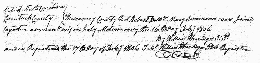
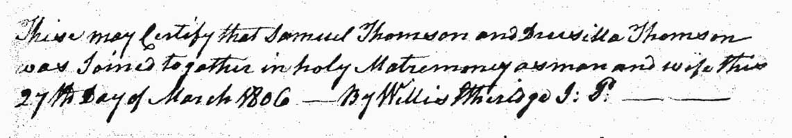