
Return to Currituck Co.
![]()
[This book starts on page 3]
[Deed Book 8; pg. 3-4] no date - Know ye that John Earl GRANVILLE for the sum of 3 (torn) paid by Joseph HAYMAN have granted unto him a parcel of land. Beginning at his own corner various courses containing 58 acres. Yielding & paying unto me yearly forever the sum of 3 Shillings or 4 Shillings for every 100 acres. /s/ E. MOSELEY; Registered Aug. 9, 1797
[Deed Book 8; pg. 4-5] Nov. 13, 1751 - Know ye that John Earl Granville have granted unto Levi STEWART a parcel of land containing in whole 235 acres. Yielding and paying unto Lord GRANVILLE the yearly rent of 9 Shillings & 5 Pence for every 100 acres. Provided that within 3 years from date hereof clear and cultivate at the rate of 3 acres for every 100 acres. /s/ GRANVILLE, James INNES
[Deed Book 8; pg. 6] no date - This may certifie that George CONAWAY & Elizabeth ROWLAND was joined together as Man and Wife in Holy Matrimony this 3rd. day of Sept. 1797. Registered Sept. 4, 1797 [MARRIAGE RECORD - see image]
[Deed Book 8; pg. 6] Aug. 25, 1797 - We Wallice BALLANCE & Joshua BALLANCE of Cape Hatterass Banks for the sum of £28 & 5 Shillings paid to us by Reuben BURRUS for a tract of land on Hatterass Banks. Beginning on the Sound side at the corner of the division line that fell to Aaron BALLANCE at division of afsd. land various courses to corner of Laben BALLANCE line with his line to the Sound side back to Laben BALLANCE line to the first containing 50 acres. Witness William BURRUS, William BALLANCE ; Registered Sept. 26, 1797
[Deed Book 8; pg. 6-7] Aug. 9, 1797 - I William DANIEL Sen. for the sum of $30 paid to me by Nicholas DANIEL for a piece of land situate on Bodyes Island. Beginning at the Sound on Gideon DANIELS South line joining said line to the sea various courses to the first containing 50 acres. Witness Joseph DANIEL, Benjamin DANIEL; Registered Sept. 27, 1797
[Deed Book 8; pg. 7] Aug. 30, 1797 - James PHILLIPS & Wife Amey of Currituck Co. sold to John ANSELL of Princess Anne Co., Va. , for $1875.00, a tract of land on Knotts Island containing 125 acres, this being the land and plantation that ANSELL sold & conveyed to Amey WHITE now the wife of said James PHILLIPS. Witnesses: Joseph FEREBEE, Thomas MARCHANT; Registered: Sept. 27, 1797
[Deed Book 8; pgs. 7-8] Aug. 22, 1797 - Asa LEE & his wife Mary LEE sold to James McCLANNEN, for 140 silver dollars, a certain parcel of land bounded as follows at a corner between McCLANNEN & Tuniah(?) WILLIAMS in said LEE line various courses to a holley on James McCLANNEN corner thence to corner of Caleb BELL & Willo. DAUGE along DAUGE line to main road, to contain 14 acres, it being a part of tract of land which Asa LEE bought of Henry BALLENTINE JUN. Registered: Sept. 27, 1797
[Deed Book 8; pg. 8] June 8, 1797 - James DOUGLAS sold to Ebenezer TAYLOR for100 pounds. Land by Coinjock Bay, bordered by Edw. TAYLORs line and Col. Asahel SIMMONS' line. /s/ James DOUGLAS. Witnesses, Josiah NICHOLSON and Ephraim (x - his mark) ROBINSON. Registered 28 Sep 1797
[Deed Book 8; pg. 8-9] June 8, 1797 - I James DOUGLASS for the sum of £100 paid to me by Ebenezar TAYLOR for a parcel of land in Cowinjock. Beginning on the plantation down to Cowinjock Bay then to down to Cowinjock Bay then as the Bay runs to Mr. Edw. TAYLOR’S side line along his line to Colo. Asahel SIMMONS line to the main road from thence to the first containing 10 acres. Witness Josiah NICHOLSON, Ephram ROBINSON; Registered Sept. 28, 1797
[Deed Book 8; pg. 9-10] June 8, 1797 - I Ebenezar TAYLOR for the sum of £100 paid to me by James DOUGLASS for a parcel of land in Cowinjock. Beginning at the Great Branch various courses binding on Lamuel WALKER’S line down his line to Saml. ONEELS line to the first containing 25 acres. Witness Josiah NICHOLSON, Ephriam ROBINSON; Registered Sept. 28, 1797
[Deed Book 8; pg. 10] Feb. 22, 1797 - I Luke BARNARD & Mary (Polley) my Wife for the sum of 490 Silver dollars paid to me by Henry BALLENTINE for a tract of land about 2 miles from Moyock Mill. Beginning along the main road running down to a gum joining James NICHOLAS dec’d land various courses to a corner joining Thos. COX & Caleb ETHERIDGE then to a corner joining John NORTHERN Esq. Edw. DOUGHTY then to the first containing 50 acres. Witness Jonathan BRITE, James GLASGOW, Andw. BATES; Registered Sept. 29, 1797
[Deed Book 8; pg. 11] Aug. 17, 1797 - We Josiah NICHOLSON & Griffin NICHOLSON & Polley his Wife for the sum of 1000 Spanish milled dollars paid to us by Adam ROBINSON of Princess Anne County Virginia for a parcel of land on Cowinjock Bay. Beginning on the West side of Cowinjock Bay where Samuel BARNS patent begins along the Bay side to Long Point various courses to the first containing 100 acres. Witness John BRUMSEY, Thos. G. JARVIS; Registered Sept. 29, 1797
[Deed Book 8; pg. 11-12] Aug. 18, 1797 - I Thomas LURRY of Camden County for the sum of £50 (also says 60 in body of deed) paid to me by Robert BARNARD for 50 acres of swamp land on the North side of North River near the Indian Line. Beginning at the Indian line binding the high land to the land Robert BARNARD bot of Wm. GRAY so far as will include & take in 50 acres. Witness Joshua HOLSTEAD; Registered Sept. 29, 1797
[Deed Book 8; pg. 12-13] Aug. 30, 1797 - We Thomas, Nathan, John & Samuel POYNER for the sum of £25 paid to us by Peter POYNER for a parcel of land lying near? North River Swamp being part of a Ridge called Narrow Ridge. Beginning on the West side of the Burnt Ground various courses to the dividing line between said Ridge & the land formerly belonging to Evan LURRY dec’d various courses to the first containing 50 acres. Witness Daniel LINDSEY, Lemuel SANDERSON; Registered Sept. 30, 1797
[Deed Book 8; pg. 13] Nov. 17, 1796 - I Spence HALL for the sum of $300 paid to me by Jacob SAWYER for a tract of land lying on Powels Point. Beginning at MASON’S land with his line to Rich’d. DOUGHS line with his line various courses to Nathan HALLS line with his line to Jacob LUTTS land with his line to James Fobes? land to the first containing 80 acres or all that tract of land that HALL bought of Wilson WEBB. Witness Absolom GREVES, John SANDERLEN; Registered Sept. 30, 1797
[Deed Book 8; pg. 13-14] Jan. 3, 1797 - I William BEASLEY of Knots Island for the sum of £5 paid to me by Henry BEASLEY for a parcel of land on Knots. Beginning at Mikel WATERFIELD line thence to James ANSELL’S line various courses to the first containing 1 acre. Witness Mordaci BEASLEY, Iracom BEASLEY; Registered Sept. 30, 1797
[Deed Book 8; pg. 14] Aug. 30, 1797 - We Thomas, Nathan, Peter & Samuel POYNER for the sum of £100 paid to us by John POYNER for a piece of land. Beginning at the main road at a path that leads to North River a corner of Wm. HOLLOWAY’S land on the Ridge thence with Wm. NICHOLSON patent to Hosea BALLS beginning of Nathan POYNER dec’d patent binding on the land of Hosea & Joshua BALL to Samuel EADY’S land various courses to Joel POYNER dec’d formerly lived then to a place called the Lorrels various courses to the first containing 300 acres. Witness Daniel LINDSEY, Lemuel SANDERSON; Registered Oct. 2, 1797
[Deed Book 8; pg. 14-15] Aug. 28, 1797 - I James DAUGE for the sum of 350 Silver dollars paid to me by Polley BARNARD Wife of Luke BARNARD for a tract of land on the Indian Ridge. Beginning at a corner between James DAUGE and Peter DAUGE various courses to Jacob PERKINS along his line to Peter DAUGE’S line along his line to the first containing 23 acres 1 rod & 33 poles: the 2nd piece beginning on the East side of James DAUGE’S plantation to Jacob PERKINS line with his line various courses to the first containing 6 acres 36 poles: the 3rd piece in the West Swamp beginning at Isaiah PARR’S corner in James HUTCHINS heirs line along his line to Caleb PARR’S line along his line to James HUTCHINS heir line along their line to the first containing 20 acres 1 rod & 11 poles all 3 pieces containing 50 acres. Registered Oct. 4, 1797
[Deed Book 8; pg. 15-16] Aug. 30, 1797 - We Thomas, Nathan, John & Samuel POYNER for the sum of £100 paid to us by Peter POYNER for a parcel of land lying between North River Swamp & East Swamp. Beginning on the West side of the East Swamp in Thos. SANDERSON’S line binding on East Swamp to Peter MORRISSETT’S line various courses to the West side of William NICHOLSON’S patent various courses to the first containing 85 acres. Witness Daniel LINDSEY, Lemuel SANDERSON; Registered Oct. 4, 1797
[Deed Book 8; pg. 16] Aug. 30, 1797 - We Nathan, John, Samuel & Peter POYNER for the sum of £100 paid to us by Thomas POYNER for a parcel of land. Beginning on the land side of Hezekiah WOODHOUSE SEN. North line various courses to the land of Thomas WHITE various courses to Poplar Branch Creek down the Creek various courses to the first containing 350 acres. Witness Daniel LINDSEY, Lemuel SANDERSON; Registered Oct. 4, 1797
[Deed Book 8; pg. 17] Aug. 30, 1797 - I Peter POYNER for the sum of £64 paid to me by Samuel POYNER for a parcel of land being the Northward part of a patent granted unto Peter POYNER for 100 acres bearing date 1796. Beginning at the Reedy Branch William HOLLOWELL’S land on the ridge various courses to the corner of Peter POYNER’S plantation to William Nicholson’s patent various courses to the first containing 64 acres. Witness Thomas POYNER, Nathan POYNER; Registered Oct. 5, 1797
[Deed Book 8; pg. 17-18] Aug. 30, 1797 - We Thomas, Peter, John & Samuel POYNER for the sum of £100 paid to us by Nathan POYNER for a piece of land. Beginning at the SE corner of Nathan POYNERs fence binding on the land he bought of David GIBSON to the North River Swamp various courses to the land whereon Sarah GIBSON dec’d formerly lived thence to the land formerly belonging to Jesse SANDERSON dec’d to the first containing 90 acres. Witness Daniel LINDSEY, Lemuel SANDERSON; Registered Oct. 5, 1797
[Deed Book 8; pg. 18] Aug. 30, 1797 - We Thomas, Nathan, Peter & John POYNER for the sum of £25 paid to us by Samuel POYNER for a parcel of land. Beginning on the West side of the Burnt Ground East side of the Narrow Ridge & on the West side of Narrow Ridge at the main North River Swamp to a place called the Lorrells with this line binding on the Swamp to the first containing 50 acres. Witness Daniel LINDSEY, Lemuel SANDERSON; Registered Oct. 6, 1797
[Deed Book 8; pg. 19] Aug. 29, 1797 - I Tulley DAUGE for the sum of £15 paid to me by Samuel DAUGE for a parcel of land in the West Swamp. Beginning in Richard HUTCHINS line it being a corner between Peter DAUGE land the premises various courses to Phillip DAUGE’S line various courses to the first containing 50 acres. Witness Robt. BARNARD, Saml. BARNARD; Registered Oct. 6, 1797
[Deed Book 8; pg. 19] Aug. 30, 1797 - We Thomas, Nathan, Peter, & John POYNER for the sum of £5 paid to us by Samuel POYNER for a parcel of land. Beginning at the Ready Branch William HOLLOWAY’S corner then binding on the land of Peter MORRISETTS to the East Swamp thence to the land formerly belonging to Reuben BALL dec’d various courses to the first containing 50 acres. Witness Daniel LINDSEY, Lemuel SANDERSON; Registered Oct. 7, 1797
[Deed Book 8; pg. 19-20] Feb. 3, 1797 - I Kezia WOODHOUSE for the natural love & affection I bear unto my Son Hadley WOODHOUSE & me hereunto moving have granted unto him all and singular my goods & chattles following: 1 mare & colt, 1 brindled cow & heifer yearling, 1 white stear, 1 brindled cow white in her face & bull yearling, 1 red cow & yearling, 1 barr plough, 1 weeding plough, 1 pot iron, 1 grubing hoe, 1 iron wedge, 1 an, 2 dishes, 2 bed stads, 1 tea kittle, 1 candle stand, 2 old hoes, ½ dozen silver tea spoons, 1 maple desl. 1 bed & firnetor, 5 sitting chairs, 2 tables, 1 looking glass, 3 iron potts, 2 pair pott trannils, 1 frying pan, 1 iron skillet, 2 pewter dishes, 2 puter basons, & 1 negroe man named George, the younger, also one negroe man George the Elder. Witness Thos. POYNER, Kezia POYNER; Registered Oct. 7, 1797
[Deed Book 8; pg. 20] April 20, 1788 - I John NORTHERN for the sum of £18 paid to me by John HAYMAN for a tract of land lying near the head of Moyock Mill. Beginning in John HAYMANs line along his line with the patent of James GLASGOWs line various courses to Elisha KIGHTs line to the first containing 100 acres.; Registered Oct. 9, 1797
[Deed Book 8; pg. 21] Jan. 18, 1796 - I Samuel WALLIS of Norfolk County Virginia, for the sum of £110 paid to me by Edward WEST for 1 negro woman named Sarah & 2 negro boys named Arter & Will which are in his actual possession. Witness Jonathan WEST, Jonathan HAILS; Registered Oct. 9, 1797
[Deed Book 8; pg. 21] July 28, 1797 - I William DANIEL for the sum of 30 Silver paid to me by Joseph DANIEL for 1 sartain parcel of marsh. Beginning at Belcher DANIELS line ajoining said line to the Sound towards Bodys Island running the corses of Belcher’s line to Joseph DANIELS line thence to the first containing 200 acres. Witness John CUDWORTH, Benjamin DANIEL; Registered Oct. 9, 1797
[Deed Book 8; pg. 21-22] Feb. 25, 1797 - I Enoch GREGORY for the sum of £130 paid to me by Belsey LAMB for a negro woman named Hannah & her child named Dennis. Witness Joseph GREGORY, Gen. LAMB; Registered Oct. 9, 1797
[Deed Book 8; pg. 22] April 19, 1797 - I Daniel FULFORD for the sum of $15 paid to me by Gracey JARVES for a piece of land. Beginning at the main road leading from Cowels Bridge to the Saw Mill at William GRIFFITH old path being Daniel KINNONs corner along road to KINNONs line so as to contain 3 acres with KINNONs line to the first. Witness Wm. SIMMONS, Henry FANSHAW; Registered Oct. 9, 1797
[Deed Book 8; pg. 22] Jan. 4, 1797 - I John WHITE orphan of Henry WHITE dec’d am held and firmly bound unto John J. WHITE for the penal sum of $400. The condition of this obligation is that John WHITE shall make unto John J. WHITE warrenting 1 acre of land and give release for 4 acres for the space of 15 years laying in the SW part of John WHITEs land. When John WHITE comes of lawful age, then this obligation is void. Test. Saml. JASPER; Registered Oct. 10, 1797
[Deed Book 8; pg. 23] July 28, 1797 - I Adam POYNER & Dinah POYNER for the sum of £33 at 8 Shillings hard money paid to me by John MASON Merchant, for a parcel of land in the Cowinjock District. Beginning at Wm. SMITH’S corner in Edw. TAYLOR’S line various courses to the first it being the NE end of the patent containing 110 acres & 10 poles. Witness Saml. PHILLIPS, Dory DAUGE, John WILLIAMS; Registered Oct. 10, 1797
[Deed Book 8; pg. 23-24] Sept. 16, 1796 - I Matthias TOLER SEN. for the sum of £50 paid to me by James TOLER for a tract of land being on the No. Banks. Beginning at the Sound side adjoining of Wm. DUNSTONs line then to the Sea side along the Sea to the Sound then along the Sound to the first containing 50 acres. Witness Mitch M. LAUGHLIN, John ADAMS, Ezeck. EVANS; Registered Oct. 10, 1797
[Deed Book 8; pg. 24] Aug. 9, 1797 - I William DANIEL SEN. for the sum of $30 paid to me by Gideon DANIEL for a peace of land lying and being on Bodyes Island. Beginning at the Sound of the South side of the first Deep Creek on the North side of Patrick’s Hamock adjoining the Creek to Joseph DANIELs line thence joining said line to the Sea various courses to the first being 50 acres. Witness Joseph DANIEL, Benjamin DANIEL; Registered Oct. 10, 1797
[Deed Book 8; pg. 24-25] Aug. 12, 1797 - I Joseph DANIEL of Ronoak Island, for the love and effection that I bear towards my Son Benjamin DANIEL have given & granted unto him a parsel of land & marsh on the Island of Ronoak. Beginning in Belcher DANIELs line in the edge of the Great Swamp various courses to Woods DANIELs corner various courses to the first containing 50 acres, taken out of 200 acres that Joseph DANIEL bought of William DANIEL taken it on the South line from Creek to the Sound. Witness Abel ASHBEE, Lazarus LINTON; Registered Oct. 11, 1797
[Deed Book 8; pg. 25] Nov. 1796 - I Jeremiah LAND for the sum of £50 paid to me by Elizabeth SCURR Widow, for ½ a tract of land that Jeremiah LAND bought of Pleasant YOUNGHUSBAND containing 81 ½ acres. Joining the lands of ETHERIDGE & BALLANCE. Witness Sol. ALCOCK, James PHILLIPS, Jno. ANSELL; Registered Oct. 12, 1797
[Deed Book 8; pg. 25-26] Nov. 1796 - I Jeremiah LAND for the sum of £250 paid to me by Elizabeth SCURR for a parcel of land being ½ of a tract that Jeremiah LAND bought of Pleasant YOUNGHUSBAND commonly known as the Court House tract. Witness Sol. ALCOCK, Jno. ANSELL, James PHILLIPS; Registered Oct. 12, 1797
[Deed Book 8; pg. 26-27] Nov. 1796 - I Jeremiah LAND for the sum of £200 paid to me by Elizabeth SCURR for a parcel of land it being ½ of a tract Jeremiah LAND bought of Pleasant YOUNGHUSBAND known by the name of Crabs Island containing 570 acres. Witness Sol. ALCOCK, Jno. ANSELL, James PHILLIPS; Registered Oct. 13, 1797
[Deed Book 8; pg. 27-28] March 3, 1797 - Stephen WESTCOT, Joseph DANIEL, Edward MANN, John WESTCOT and Abel ASHBEE, Esq. were sworn in as commissioners to divide the real estate of Thomas MIDYETT, dec'd. on July 29, 1797. The plat represents 230 acres of land situated on Roanoak Island, beginning on the Sound side at the line of the land formerly belonging to Joseph Mann dec’d.; Registered Oct. 16, 1797.
The commissioners
awarded to:
1. Azariah BAUM, husband of Sarah who was the daughter of Thoams
MIDYETT, dec'd., 76 1/2 acres of land joining the land of Abel ASHBEE
and Morris BAUM.
2. Nancy MIDYETT, daughter of Thomas MIDYETT, dec'd., 76 acres of
land joining the land of Joseph MANN and Solomon ASHBEE.
3. Barbara MIDYETT, daughter of Thomas MIDYETT, dec'd., 76 1/2
acres joining the land of Joseph MIDYETT, Samuel MIDYETT and the Sound. Barbara MIDYETT shall pay to Nancy MIDYETT the sum of
£63 & 6 shillings. Barbara MIDYETT shall pay to Azariah BAUM,
husband of Sarah MIDYETT,
£49 & 6 shillings.
/s/ Edward MANN, Joseph DANIEL, Stephen WESTCOT, Abel ASHBEE, John WESTCOT
[Deed Book 8; pg. 28] Sept. 2, 1796 - To Solomon ALCOCK Sheriff of Currituck County, you are to summons Major CLARK Esq., Thomas FARROW, Daniel TOLSON, William ROLLASON & Thomas QUIDLEY commissioners with the County Surveyor to meet on the premises & divide the real estate of William BALLANCE deceased.
[Deed Book 8; pg. 28-29] July 27, 1797 - In obedience of the above order of the Court, we the subscribers have divided the real estate of William BALLANCE deceased as follows:
1st
William BALLANCE 76 acres adjoining his Brother John BALLANCE from Sea to Sound.
also 12 ½ acres near the Cape Hatterass joining John WALLIS
Caleb
BALLANCE 76 acres adjoining on William BALLANCE also 12 ½ acres joining William
Aaron
BALLANCE 76 acres adjoining on Caleb BALLANCE, also 24 ¼ acres joining Courtney
Wallis
BALLANCE 76 acres adjoining on Aaron BALLANCE, also joining of Aaron 24 ¼ acres
Joshua
BALLANCE 76 acres adjoining on Wallis BALLANCE, also 24 ¼ acres joining Wallis
Sarah
AUSTON 76 acres joining Joshua BALLANCE also 24 ¼ acres joining Thos. Auston
Sen. at the old Inlet
Barbara
BALLANCE 76 acres joining Sarah AUSTON, also 24 ¼ acres joining Laben
Courtney
BALLANCE 76 acres joining Barbara BALANCE also 24 ¼ acres joining Sarah AUSTON
Laben
BALLANCE 76 acres joining Courtney BALLANCE, also 24 ¼ acres joining Joshua
First
division of land represents 684 acres of land on Hatterass Banks belonging to
William BALANCE beginning at John BALLANCEs line to Wm. QUIDLEYs line to
DUNKINs corner various courses to Mr. JACKSONs land various courses to the
first.
2nd
piece of land containing 25 acres of land beginning at Mr. WALLIS’S line to the
first.
Witness Thos. POYNER Sur.; Registered Oct. 16, 1797
[Deed Book 8; pg. 29-30] April 20, 1745 - Know ye that we do give & grant unto Jacob FARROW a tract of land containing 492 acres between Spencers & Follies Creek at Cape Hatteras. Beginning at Folley Creek running to the Sound various courses to the first. Yielding and paying unto us forever the yearly rent of 4 Shillings for every 100 acres to be paid on Feb. 2 of every year. Provided always that in case Jacob FARROW shall within space of 3 years from date hereof seat the same with one white person & also Letters Patents shall be entered within 6 months from date hereof. /s/ Gab. JOHNSTON; Enroled in Aud. Generals office July 20, 1745; Registered Nov. 13, 1797
[Deed Book 8; pg. 30] Nov. 25, 1797 - To the Sheriff of Currituck County, you are to summons Jonathan LINDSEY, Leml. GREGORY, William MELSON, Zorobable HARRISON & David LINDSEY along with County Surveyor to meet on the premises & run the dividing line between John GIBBINS’ Orphans & Benjamin SIKES. ; Registered Dec. 18, 1797. In obedience of above Court Order we the subscribers having met on the premises & having heard witnesses on both sides have run the dividing line in following manner: beginning on Albemarl Sound various courses to the NW end of Deep Pond.; Registered Dec. 18, 1797
[Deed Book 8; pg. 30] Sept. 11, 1797 - To the Sheriff of Currituck County, you are to summons a jury of 12 men unconnected with the parties along with the County Surveyor to meet on premises & lay off & assign to Mary POYNER her Dower of the lands of Lemuel POYNER dec’d.; Registered Dec. 18, 1797
[Deed Book 8; pg. 30-31] Oct. 19, 1797 - In obedience to above Court Order we the subscribers proceeded to lay off & set apart & assign to Mary POYNER her Dower to a tract of land known by Lemuel POYNER’S in the following manner. Beginning on the West side of the main road near Mr. Thomas (faded out) & SE corner of the plantation whereon Lemuel POYNER dec’d formerly lived various courses containing 9 ¾. /s/ Gamial WRIGHT, Elijah ADDERSON, Thos. FORBES, Thos. HEATH, Thos. BERNARD, Joseph DOWDEY, Jacob DOWDEY, Nathan POYNER, Thos. SANDERSON, Mitchel DAUGE, John SANDERSON, Josiah DOWDEY. Witness Thos. POYNER Sur.; Registered Dec. 18, 1797
[Deed Book 8; pg. 31] Sept. 8, 1797 - I Thomas PARKER for the sum of £200 paid to me by Jesse PERRY for a tract of land situate in Hide County. Beginning at the head of Swan Quarter Bay binding on the old patent land & being a new patent of Thomas PARKER took up containing 540 acres. Witness Thos. HEATH, Saml. SALYEAR; Registered Dec. 18, 1797
[Deed Book 8; pg. 31-32] Mar. 17, 1797 - I Thomas WILLOUGHBY for the sum of $120 paid to me by John WALMSLEY of Camden County for 2 tracts of land near the head of WALMSLEY’S Mill Pond. Tract 1 beginning in the line formerly BROOKS, now WALMSLEY’S in the Mill Run then to John WHEATLEY’S line along his line various courses to the first containing 50 acres. 2nd tract beginning on back of above mentioned land being ¼ part of a patent granted to WALMSELY Nov. 18, 1790 for 161 acres which was conveyed to Thomas WILLOUGHBY by WALMSLEY by deed dated Aug. 17, 1794 and contains 40 ¼ acres. Witness James McCLAHORSON?, Will. WILLIAMS ; Registered Dec. 19, 1797
[Deed Book 8; pg. 32] Sept. 15, 1797 - William O'DOWDY sold to the heirs of Alexander WHITEHALL for £12 &10 shillings, 20 acres in Currituck formerly belonging to Hillary HASENERS, deceased. Witness Mary POYNER, Benjamin TAYLOR, Nancy (x) KUTIT?; Registered Dec. 19, 1797
[Deed Book 8; pg. 33] Oct. 3, 1797 - I James WILLIAMS & Sarah my Wife for the sum of £125 paid to me by John MERREL for a parcel of land lying on Powels Point. Beginning at a corner of Josiah CURLINS line with his land to Sampson ETHERIDGE line various courses to the first containing 30 acres. Witness Nathan HALL, Zorobable HARRISON; Registered Dec. 20, 1797
[Deed Book 8; pg. 33-34] Oct. 17, 1794 - I Laban GRAY & Mary my Wife for the sum of 10 Spanish Milled dollars paid to me by Lazarus LINTON & George CLARK for a messuage of land on the No. Banks. Beginning at the Sea CAMPBELLs & LEVINs line being the first of the LEVINs land on the north side of the glade then to James CAMPBELLs line to the Sound to Horse Island Creek then to the Sea various courses of the Sea to the first containing 1000 acres. Being the land of said LEVIN held & occupied in the year 1762 & Mary GRAY being the Grand Daughter of LEVIN dec’d. Witness William AYDELOTT, S. HALL ; Registered Dec. 20, 1797
[Deed Book 8; pg. 34] Mar. 14, 1796 - I William LINDSEY for the sum of £106 hard money paid to me by Lemuel SIMMONS for a negro boy known by Gid. Witness John SIMMONS, David LINDSEY; Registered Dec. 20, 1797
[Deed Book 8; pg. 34-35] May 22, 1797 - I Zebulon LEE for the sum of $120 paid to me by John WALMSLEY of Camden County for a tract of land adjoining Asa LEE’S land containing 65 acres. Being the land left to me by Will by my Father Thomas LEE subject to his Mothers Dower. Witness Klyah SAWYER, Cornelius SAWYER; Registered Dec. 21, 1797
[Deed Book 8; pg. 35] Nov. 29, 1797 - I Solomon ALCOCK by virtue of an Execution directed against the estate of John Man BURMEY sold at publick sale one negro girl named Amy to Robean CATAR for the sum of £50, 13 Shillings & 6 Pence, he being the highest bidder. Witness S. HALL; Registered Dec. 22, 1797
Deed Book 8; pg. 35] April 6, 1796 - Saml. MIDYETT, planter of Roanoak Island in Currituck County, sold to Abel ASHBEE, planter of the same place, for 500 Spanish Milled Dollars, a tract of land lying on Roanoak Island beginning near the head of the thoroughfare running north and running to Broad Creek, then along the sd. creek to the North end of Catarines Swamp then to Croatan Sound, containing 450 acres. /s/ Samuel MIDYETT. Witnesses: Laz's. LINTON, Stephen WESKITT; Registered: Dec. 22, 1897
[Deed Book 8; pg. 35-36] Oct. 26, 1797 - Cornelius DAVIS and Tamer his wife sold to Aaron BRIGHT, all of Currituck, for £100 land in Currituck known by the name of HAYMAN's place, whereon the aforesaid HEYMANs widow now lives and which land was sold by Saml. SALYEAR Esq. Sheriff by a deed dated 27 Aug 1794. By the lands of Marmaduke COX, John NORTHERN, the heirs of Joseph MAYS and Thomas COX. Witness, Jos. BALLENTINE, Wm. ROBERTS; Registered 22 Dec 1797
[Deed Book 8; pg. 36] Nov. 2, 1797 - Ebenezer TAYLOR sold to Thomas TAYLOR for 130 silver dollars, 20 acres bounded by Abraham DOUGLAS property. Witness Willis ETHERIDGE; Registered 23 Dec 1797
[Deed Book 8; pg. 37] Oct. 26, 1797 - We Aaron & Willis BRIGHT for the sum of £100 paid to us by Cornelius DAVIS for a parcel of land. Beginning at a run near Javon COX various courses to the first containing 70 acres. Witness Jos. BALLENTINE, Wm. ROBERTS; Registered Dec. 26, 1797
[Deed Book 8; pg. 37-38] Oct. 3, 1797 - I Solomon COX & Frances my Wife for the sum of £60 paid to me by Jesse Ives for a tract of land. Beginning along John POWERS line to George FORKERs line along his line to Samuel POWERS line with his line to the main road along the road to the first containing 50 acres. Witness Jos. BALLENTINE, Henry BALLENTINE; Registered Dec. 26, 1797
[Deed Book 8; pg. 38] Nov. 28, 1797 - I Peter MORRISET for the sum of £8 paid to me by Samuel POYNER for a tract of land that Peter MORRISET bought of Joseph GRAY & Wife Mary GRAY containing 3 acres. Witness Thos. POYNER, Nathan POYNER; Registered Dec. 26, 1797
[Deed Book 8; pg. 39] Feb. 13, 1796 - I John LINDSEY for and in consideration of one yair of corn for each year have let & leased unto Abraham HITER during his life 15 acres whereon HITER now lives. HITER is not to lease or rent the land to any person whatsoever and if he dose this lease is to be forfeited. Witness Nathan HALL; Registered Dec. 27, 1797
[Deed Book 8; pg. 39] Nov. 27, 1797 - Joseph FEREBEE, executor of John HUMPHRIES, sold to Saml. FEREBEE for £153 & 10 shillings, 100 acres lying in Currituck being a part of a tract of land surveyed and patented by Absalom LEGETT, bounded by Elisha JENKINS (formerly Hilary SIMMONS), James JENKINS, Moses FANSHAW. Witness Wm. TAYLOR; Registered 27 Dec 1797
[Deed Book 8; pg. 40] Aug. 31, 1797 - I John POWERS for the sum of $6.25 paid to me by Elizabeth POWERS for 1/6 part of the tract of land that Caleb POWERS Father of John POWERS bought of Jeremiah SEXTON joining William SEXTON, Moses BALLANCE, & Thos. W. Hopper. Witness James POWERS, Caleb ETHERIDGE; Registered Dec. 27, 1797
[Deed Book 8; pg. 40] Nov. 6, 1797 - I Cornelius DAVIS for the sum of £40 paid to me by Aaron BRIGHT for a tract of land being the tract that Cornelius DAVIS boat of Aaron BRIGHT & Willis BRIGHT containing 20 acres. Witness Jos. BALLENTINE, Peter BALLENTINE; Registered Dec. 28, 1797
[Deed Book 8; pg. 41] Sept. 4, 1797 - I Willoughby DAUGE for the sum of 625 Silver dollars paid to me by Samuel FEREBEE for a parcel of land. Beginning at a corner of a patent granted to Mitchel DAUGE then to Tulley DAUGEs corner along his line various courses to Phillip DAUGEs then to ETHERIDGEs corner then to the Indian line to Joseph GREGORY & Christopher WILLIAMS corner to the corner of the old Indian patent along the Indian line to the first containing 60 acres. Witness Enoch DAUGE, Dennis DOZIER; Registered Dec. 28, 1797
[Deed Book 8; pg. 41-42] Mar. 25, 1797 - We Betsey STANLEY, Miles Perkins & Wife Nanseyof Camden County are held & firmly bound unto Samuel FEREBEE in the just sum of £800. The condition of this obligation is such shall at any time when required after Nansey PERKINS arrives to the age of 21 make a sufficient good title by deed to Samuel FEREBEE for a tract of land lying near Indian Ridge containing 133 acres & ¾ agreeable to a patent granted to ohn STANLEY dec’d dated Oct. 27, 1784. In case either Nansey or Betsey should die before Nansey reaches 21 then the survivor shall issue the deed without delay. Witness Thomas MERCER, David GREGORY; Registered Dec. 28, 1797
[Deed Book 8; pg. 42] Nov. 25, 1797 - I Christopher WILLIAMS for the sum of $728.50 Silver dollars paid to me by Samuel FEREBEE for a parcel of land. Beginning at Joseph GREGORY’S corner in the Indian line along his line various courses to the Deep Run then to the first containing 140 acres. It being a part of that tract of land which formerly belonged to Thos. MACKNIGHT & sold by George POWERS Sheriff to Thomas WILLIAMS Sen. & by him in his Last Will & Testament given to Christopher WILLIAMS which land is part of the Indian tract. Witness Griffith DAUGE, James FEREBEE; Registered Dec. 29, 1797
[Deed Book 8; pg. 42-43] Jan. 14, 1797 - We William & Richard ETHERIDGE for the sum of 80 Spanish dollars paid to us by Barnebee ETHERIDGE for a messuage of land on Ronoak Island. Beginning at Abel ASHBEEs corner along his line to Stephen WESKETTs line along his line to Stephen BEASLEYs line along his line to the first containing 33 acres. Being 2/5 of the land Tart ETHERIDGE purchased of Abraham BAUM, and 2/5 of the land that Tart ETHERIDGE purchased of Henry BEASLEY, being our dividend of the 2 purchases of land. Witness Laz. LINTONN, John WESKETT; Registered Dec. 29, 1797
[Deed Book 8; pg. 43] Jan. 14, 1797 - We William & Richard ETHERIDGE for the sum of 40 Spanish dollars paid to us by Barnibee ETHERIDGE for a messuage of land lying on the N.E. side of Ronoak Island. Beginning at Abel ASHBEEs line then to the Sound by various courses of the sound back to ASHBEEs line then to the first containing 20 acres. It being 2/5 of the land that Tart ETHERIDGE purchased of Wm. DANIEL for 50 acres, & being our dividend of that purchase. Witness Laz. LINTON, John WESKETT; Registered Dec. 30, 1797
[Deed Book 8; pg. 44] June 1, 1797 - Josiah NICHOLSONsold to James BATES for £200 for land joining Tulls Creek, WILLIAMS' Line, and Willis BALLANCE. Witness, Jesse SIMMONS, Andrew DUKE, Jacob PERKIN; Registered 1 Jan 1798
[Deed Book 8; pg. 44] Sept. 1, 1788 - I William FEREBEE for the sum of £275 paid to me by Samuel FEREBEE for a messuage of land. Beginning on the main road binding on Indian Ridge road to Sams Run binding on William LURRY’S land & Griffith DUAGE’S land to John HUMPHRIES corner then to the first containing 200 acres. Being the ½ of that tract sold by Malachi WILSON & Lydia his Wife to Thomas MACKNIGHT & George POWERS Sheriff to Isaac GREGORY Esq. & from GREGORY to William FEREBEE. Witness Wm. TAYLOR, Alex. WHITEHALL; Registered Jan. 1, 1798
[Deed Book 8; pg. 45] May 27, 1797 - This deed is a survey of map of 640 acres lying on the South side of Currituck Inlet for James WHITE surveyed by Thomas POYNER. Beginning at the edge of the sand near the Garden Hammock Cove various courses to the Sea, Marsh, & mainland. Chain bearers Cornelius GREGORY, William BERRY. These may certify that the above course is rectified in and old patent granted to John WHITEHEAD by order of the Currituck Court Oct. 13, 1797. Registered Jan. 20, 1798
[Deed Book 8; pg. 45-46] Feb. 20, 1743 - Know ye that we do give and grant unto John WHITEHEAD a tract of land containing 640 acres of land on the Southside of Currituck Inlet. Yielding & paying unto us forever the yearly rent of 4 Shillings for every 100 acres to be paid on Feb. 2 of each year. Provided that John WHITEHEAD shall within 3 years seat with 1 white person & these letters Patents be entered in the office of the Auditor Generals within 6 months of the date hereof. /s/ Gab. JOHNSTON; Enroled in aud. Generals office March 26, 1743. Registered Feb. 6, 1798 So fare as I can understand it, as it is very much torn to peaces and defaced. /s/ Willis ETHERIDGE
[Deed Book 8; pg. 46] June 25, 1797 - Know all men by these presents that I Thomas SANDERSON SEN. & Son of Thomas SANDERSON Deceas’d for and in consideration of the sum of 26 Silver Dollars to me paid by Zorobable HARRISON of the afsd. County before the insealing & Delivering of these presents, the Receipt whereof he doth hereby acknowledge have bargained and sold & by these presents doe bargain sell make over & convey unto the afsd. Zorobable HARRISON & his heirs for ever all and every article & property that may belong to me at the Death of my Mother Ann SANDERSON widow of Thos. SANDERSON deceas’d out of or from the Estate of my said Father Thos. SANDERSON deceased if it be nigroes stock or house hold furniture or any other article what ever & I do likewise for the consideration above said make over and convey unto the afsd. Zorobable HARRISON & his heirs for ever all my part of the estate of my Brother John SANDERSON deceased which is now in the possession of my Mother Ann SANDERSON or all of my sd. Brothers Estate which will belong to me or my heirs at the death of my sd. Mother whether it be in negroes stock or household furniture or any other property what ever and I hereby impower the said Zorobable HARRISON to use all lawfull ways for the recovery of the afsd. Property or any part thereof in as full a manner as I possibly could have done had I not transferred the same and I the afsd. Thomas SANDERSON do agree to & with the said HARRISON to warrant and defend the said property against my right title or claim that me or my heirs may ever Law (sic) to the same but do hereby acknowledge that I have rec’d full satisfaction & payment for every part and parcel thereof.
[Deed Book 8; pg. 47] Mar. 21, 1797 - This Lease and articles of agreement entered into by Daniel LINDSEY guardian to Robert WEST orphan of George D. WEST Deceas’d. of the one part and Zorobable HARRISON of the other part. Witnesseth that I the afsd. Daniel LINDSEY for and in behalf of the orphan afsd. Do Leese or rent unto the afsd. HARRISON for and during the term of seven years all the said orphans part of the land and plantation whereon the said orphans Father formerly lived lying to the South East of the house where Edward PARKER now lives with all the priviledges and benefits to the same belonging and the afsd. HARRISON in consideration of the above agrees & obliges himself his heirs or assignes to pay to afsd guardian three pounds & eleven shillings at the expiration of each year and to clear all the land that is now within the fence and at the expiration of the seven years afsd. To deliver the said plantation to the guardian afsd. or other person authorized to receive it for the orphan afsd in good order for tillage under a good fence for the due performance of the above.
[Deed Book 8; pg. 47] Jan. 9, 1798 - I Thomas MILLER of the County of Currituck & State of North Carolina am held and firmly bound unto Jphn BALLANCE of the same County & State afsd. In the full sume of £100 currency, to be paid unto the said John BALLANCE his heirs Executors, Adm. Or assigns. To which payment to well and truly to be made and done I bind my self my heirs executors & adm. Jointly and severally firmly by these presents. The condition of the above obligation is such that if the above bounden Thomas MILLER do and shall will and truly against all the possions of his present wifes Dower of all her land & houses, during his life by the last day of this Instent. Excepting the afsd. BALLANCEs. Leave only his Mother may live in the house if she pleases; One other person without the afsd. BALLANCEs leave or and upon such absolute performances this obligation to be void, other wise in full force and virtue afsd. Witness my hand & seal the day & date above written. /s/ Thos. MILLER
[Deed Book 8; pg. 47-48] Feb. 16, 1798 - I Jesse SIMMONS for the sum of £540 paid to me by Josiah BELL of Camden County for a piece of land. Beginning at the main road being the N.E. corner of a piece of land formerly belonging to Benjamin CRABB along his line to VANDIMORS patent line with his line to Agness ETHERIDGES corner with her line to Jolliff HOLSTEAD’S line along his line to John WHEATLEY’S patent line along his line to Simon MATTHIAS line to Andrew BATES line with his line to the first containing 180 acres. Witness Samuel DOZIER, Wm. SIMMONS; Registered March 23, 1798
[Deed Book 8; pg. 48] Feb. 22, 1798 - I Seth HOLSTEAD for the sum of 100 Spanish dollars paid to me by John BERRY for a tract of land. Beginning at Buckskin Creek William BAXTER’S deceased orphans corner with his line to John PERKINS orphans line with his line to John CALLIS orphans line with her line to the Creek up the Creek to the first containing 50 acres. Witness Jesse SIMMONS, Geo. FALLIS?; Registered March 23, 1798
[Deed Book 8; pg. 48-49] Oct. 2, 1796 - I John Padrick ADAMS for the sum of £3 10 Shillings paid to me by Lemuel GREGORY for a piece of land lying on Powels Point, beginning at Charles DICKES N. line various courses to the first containing 2 acres. Witness Nathan HALL, Wm. CHANDLER; Registered March 23, 1798
[Deed Book 8; pg. 49] Oct. 3, 1797 - I Thomas WHITEHALL for the sum of £65 paid to me by Elija ADERSON for a piece of land ajoining Thomas WHITES land. Beginning in Alexander WHITEHALL’S line to the swamp side binding the swamp to Hillary HANNAH old field to the first containing 30 acres. Witness G. WRIGHT, Robert WHITEHALL; Registered March 23, 1798
[Deed Book 8; pg. 49] Feb. 27, 1798 - I Solomon ALCOCK Esq. Sheriff having been ordered by Writ of Firifaces issued out of the County Court of Pleas & Quarter Sessions, commanding me out of the goods, chattles & lands of Hollowell ETHERIDGE & cause the sum of £57 7 Shillings 9 Pence which was lately recovered by John ARMSTRONG of Norfolk County Virginia. In obedience of Writ after advertising did meet on the premises & by consent & request of Hollowell ETHERIDGE sold as much of lands to John ARMSTONG @ 13 Shillings per acre to satisfy execution & cost amounting in all to £72 18 Shillings & 5 Pence. The land binding on Samuel Lee’s line & on the marsh & Wm. ETHERIDGE orphan of John ETHERIDGE dec’d line until an East course will contain 112 acres. Witness Wm. TAYLOR, S. FEREBEE; Registered March 24, 1798
[Deed Book 8; pg. 50] Dec. 11, 1797 - I William DUDLEY for the sum of £5 paid to me by Richard BEESLEY for a messuage of land. Beginning at the corner of Willis WICKER’S line thence containing all the land that DUDLEY owns to the Westward of WICKER containing 1 acre. Witness Saml. JASPER, William WICKER; Registered March 26, 1798
[Deed Book 8; pg. 50-51] Feb. 20, 1798 - I Samuel SALYEAR Esq. Sheriff having been ordered by Writ of Fierfacies issued out of the County Court of Pleas & Quarter Session commanding me out of the goods, chattles & lands of John HAYMAN to cause the sum of £3 4 Shillings 7 Pence lately adjudged to Thomas WILSON against the adm. of HAYMAN. Also to Witt of the goods, chattles & lands of John HAYMAN to cause the sum of £2 5 Shillings 11 Pence which was lately adjudged to John NORTHERN against Telemaues SHERGOLD Exec. of HAYMAN. I did enter & take possession a tract of land beginning in the line that divides this land & Henry WILLIAMSON then to Esq. NORTHERNs line then to a branch near WILLIAMSONs house various courses to the first containing 20 acres. After legal notice land was exposed for sale on Aug. 23, 1794 where & when Edward DOUGHTY of Norfolk County Virginia appeared & bid the sum of £10 & was highest bidder. By virtue of Writ I Samuel SALYEAR Esq. Sheriff did convey unto Edward DOUGHTY the parcel of land. Witness Wm. TAYLOR, Solo. ALCOCK; Registered March 26, 1798
[Deed Book 8; pg. 51-52] Dec. 27, 1797 - I Samuel SALYEAR Jun. for the sum $7 paid to me by Charles GRIGGS for a parcel of land & marsh situate on the Banks. Beginning at the Sea side at William SNEEDEN’S line then with his line to a Creek or Bay so far as will make 50 acres. Witness Sally SALYEAR; Registered March 26, 1798
[Deed Book 8; pg. 52] Feb. 20, 1798 - I Thomas WHITEHALL for the sum of £2 paid to me by Daniel DUNTON for a parcel of land containing ½ acre lying in the South part of a patent granted to William BELL bearing date Nov. 20, 1714. Witness Nathan POYNER, Samuel GREGORY; Registered March 27, 1798
[Deed Book 8; pg. 52-53] May 8, 1797 - I Henry GIBSON for the sum of 150 Silver dollars paid to me by Thomas GIBSON for a parcel of land. Beginning on the W. side of the main road & N.E. corner of Henry GIBSONs fence binding Thomas JARVIS various courses to the first containing 84 acres. Witness Thos. POYNER, Kezia POYNER; Registered March 27, 1798
[Deed Book 8; pg. 53] Feb. 27, 1798 - I Andrew DUKE for the sum of £30 paid to me by William MELSON for a parcel of land on Kitty Hawk Banks between Kitty Hawk Bay & Jean Gite Creek. Beginning at Dempsey WALKERs line on Northerns Gut to WALKERs line to patent line various courses to the first containing 250 acres. Witness Nathan NATRS, Griffith DAUGE; Registered March 28, 1798
[Deed Book 8; pg. 53-54] Jan. 6, 1798 - I Gaius WILLIAMSON of Norfolk County Virginia for the sum of 1000 Spanish dollars paid to me by Capt. Andrew BATES for a piece of land. Beginning at the road near Jesse SIMMONS various courses to the first containing 246 ½ acres. Witness Jona. WILLIAMSON, Francis WILLIAMSON, Leml. WILSON; Registered March 28, 1798
[Deed Book 8; pg. 54-55] Jan. 27, 1798 - I Jesse SIMMONS for the sum of 400 Spanish dollars paid to me by Obediah CAPTS for 2 tracts of land 1 of them being the land I bought of Jolliff HOLSTEAD. Beginning at Benjamin COWELs corner with his line to Elias DAUGE orphan land then with his land to James CHITTONs orphan land with his line to William POYNERs line with his line various courses to the first containing 75 acres: also 25 acres on Buckskin Island it being all the land given by William BAXTER dec’d to his Daughter, Mary BAXTER. Witness Simon MATTHIAS, Jeremiah PERKINS; Registered March 28, 1798
[Deed Book 8; pg. 55] Feb. 12, 1799 - I William Dudley for the sum of 25 Silver dollars paid to me by Richard BEESLEY for a parcel of land lying on Knots Island. Beginning at a corner near William DUDLEY & Richard BEESLEY & William WICKER then up WICKER’S land various courses to John GIVINS land thence to a corner between DUDLEY John GIVIN & the heirs of Ely SMITH down SMITHs various courses to the first containing 2 acres. Witness M. JONES, William WICKER; Registered March 28, 1798
[Deed Book 8; pg. 55-56] Dec. 6, 1796 - I Mitchel DAUGE doth lease a sertain piece of land unto James SPELMAN for the term of 7 years, the land various courses to contain 10 acres. James SPELMAN is to put the high ground under good fence & to have it the first year for 4 Pence & after 1 barrel of corn pr. Year for 4 years & he is to build a 3’ ditch & other ditches sufficient to drean the land, & is to rase sow & pigs pr. year. Witness Saml. ETHERIDGE, John BAXTER; Registered March 29, 1798
[Deed Book 8; pg. 56] Feb. 24 1798 - Moses Showcroft? CAMPBELL of Currituck Co., sold to Jesse SIMMONS of Currituck Co., for 400 Spanish Milled Dollars, a tract of land lying near Currituck Shore beginning by the main road at George ROLINGS corner, then to John KINNAN?'s former line...., containing 60 acres. /s/ Moses Shoecroft? [x] CAMPBELL. Witnesses: Zachariah MORSE, Obadiah CAPTS. Registered: March 29, 1798.
[Deed Book 8; pg. 56-58] Dec. 27 & 27,
1797 - Michal ONEEL,
dec'd, division of his real estate. Commissioners appointed to survey and
divide his real estate among his lawful representatives. This plan
represents 150 acres of land situated in Currituck Co. on the South part of
Piney Island, formerly the property of Michel ONEEL, dec'd., and bounded as
follows: Beginning at a stake on Cowinjock Bay thence running down said bay to Joseph GRAY's land, then to a stake in the marsh between Piney & Churches
Island, then to the beginning. /s/ Thos. POYNER, SENR.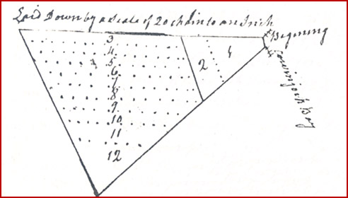 We, the commissioners have divided the real estate of Michal ONEEL as
follows:
We, the commissioners have divided the real estate of Michal ONEEL as
follows:
#1 Bridget BALL - 121/2 acres on Cowinjock Bay
#2 Nathan ONEEL - 121/2 acres
3# Charlotte POYNER - 121/2 acres
#4 Sarah JARVIS - 121/2 acres
#5 Frances CREEDLE - 121/2 acres
#6 Ann GRAY - 121/2 acres
#7 Mary WALKER - 121/2 acres
#8 Dorcas JARVIS - 121/2 acres
#9 Samuel ONEEL - 121/2 acres
#10 Elizabeth BALL - 121/2 acres
#11 Rebackah HOLLOWAY - 121/2 acres
#12 Julian McHORNEY - 121/2 acres
[Deed Book 8; pg. 58] February 14, 1797 - William LOWDER of Currituck Co. sold to Thomas GREGORY of Currituck Co., for £100, 4 1/2 acres of land lying on Powels Point and binding on Joshua CURLING. /s/ William LOWDER. Witnesses: Joshua HARRISON, M. LAYHLIN; Registered: March 30, 1798
[Deed Book 8; pg. 58] Mar. 21, 1796 - Daniel LINDSEY, guardian to Robert WEST, orphan of George D. WEST, dec'd., sold to Zorabable HARRISON, a tract of land belonging to the afsd. orphan where on the said HARRISON now lives and to extend to the South East as far as Nancy WEST's land, containing 50 acres, with all the benefits belonging for the term of 9 years, on the following conditions which the said HARRISON doth hereby oblige himself to perform, viz: Said HARRISON agrees to build a framed house 16 feet long and 14 feet wide with a plank floor about and below & to clear, fence and put in good order for tillage 10 acres of land and to deliver the afsd. house plantation and improvements into the said orphan at the time of his coming to the age of 21 years. /s/ Daniel LINDSEY. Witness: Nathan HALL; Registered: March 30, 1798
[Deed Book 8; pg. 58-59] Apr. 18, 1797 - We Miles PERKINS & Elizabeth STANDLEY are held & firmly bound unto James BALLENTINE in the just sum of £400. The condition of the obligation is such that Miles PERKINS & Elizabeth STANDLEY shall make a good & lawful right to a parcel of land lying in Moyock District near Moyock Mill. It being the parcel of land whereon James BALLENTINE now lives containing 28 acres. Witness Jos. BALLENTINE, Thos. FEREBEE; Registered March 30, 1798
[Deed Book 8; pg. 59] Aug. 2, 1797 - I William DUDLEY for the sum of £8 paid to me by Willis WICKER for 2 acres of land lying on the Westward of Richard BESELY lands he bought of William DUDLEY & down to Jacob LITCHFIELDs line. Witness Elizabeth BESELY, Malachi DUDLEY; Registered March 30, 1798
[Deed Book 8; pg. 59-60] Sept. 4, 1797 - I Willoughby DAUGE Planter, for the sum of £110 paid to me by Joseph SANDERLIN Planter of Camden County, for a negro woman called Nancy & a girl child called Fillis. Witness S. FEREBEE, Dennis DAUGE; Registered March 30, 1798
[Deed Book 8; pg. 60] June 19, 1797 - I Thomas BROWN for the sum of £50 paid to me by Richard DAUGE for a tract of land on Powels Point. Beginning at Jeremiah GIBBINS corner binding on DAUGE line then to James Thomas’s line back to GIBBIN’S line along his line to the first containing 12 acres. Witness Fredrick DAUGE, M. LAUGHLIN; Registered March 31, 1798
[Deed Book 8; pg. 60] Dec. 12, 1797 - Ebenezer TAYLOR & his wife Susannah sold to Thos. WILLIAMS, all of Currituck Co., for £40, 25 acres near Cowinjock Bay beginning at DUNTON Landing, and bounded by Thomas WILLIAMS & John FISHER. It being part of the patent granted to Wm. BELL bearing the date of 20 Nov 1714. /s/ Ebenezer (x) TAYLOR. Susannah (x) TAYLOR. Witnesses, Chas. V. HERBERT, Thos. BRUMSEY; Registered 31 Mar 1798
[Deed Book 8; pg. 61] Jan. 25, 1798 - I John CHURCH & Elizabeth my Wife for the sum of £125 paid to me by Davis FANSHER for a tract of land containing 80 acres. Beginning at Gordens Creek then to Peter FEREBEE’S line with his line to Bray’s Creek various courses to the first. Witness Andrew BATES, James BATES, Hollo. ETHERIDGE; Registered March 31, 1798
[Deed Book 8; pg. 61-62] Feb. 26, 1798 - I Sarah JONES for the natural love and affection which I bear unto my beloved Son David JONES and for the consideration me hereunto moveing have given & granted unto him a negro boy named John. Witness M. JONES, John SIMPSON; Registered April 21, 1798
[Deed Book 8; pg. 62] Feb. 28, 1798 - I Solomon ALCOCK Sheriff by order of a Writ of Feiri Facises I have been commanded to out of the goods, chattles & lands of Elias WILLIAMS guardian of BONNEYs orphans to cause the sum of £141, 10 Shillings & 5 Pence which was lately adjudged to James ANSELL. By order of Writ I did enter & take into possession 2 negro women Isabel & Chaina which was of the property of BONNEY orphans. On Oct. 17, 1797 after due legal notice the negroes were put up for sale at public vendue when & where Elias WILLIAMS SEN. appeared & bid £67 & 1 Shilling for Isabel, & £67 & 15 Shillings for Chaina which was the highest bid. By virtue of Writ I Solomon ALCOCK have granted & conveyed unto Elias WILLIAMS the said negroes. Witness S. FEREBEE, William WILLIAMS; Registered April 2, 1798
[Deed Book 8; pg. 62-63] Dec. 12, 1797 - Thos. BRUMSEY sold to Ebenezer TAYLOR, both of Currituck, for 180 silver dollars, 52 acres in Coinjock bounded by John FISHER, Joseph SIMMONS, & Thos. WILLIAMS. /s/ Thos. BRUMSY, Anas BRUMSEY; Witnesses, Chas. V. HERBERT, Thos. WILLIAMS; Registered 24 Apr 1798
[Deed Book 8; pg. 63] Jan. 3 1798 - I Dory DAUGE for the sum of 500 Silver dollars paid to me by Samuel FEREBEE for 4 negroes, a woman Mariam, 2 boys Sam & Nias & negro girl Miriam twins. Witness Joseph FEREBEE, William BRUMSEY; Registered April 2, 1798
[Deed Book 8; pg. 63-64] Feb. 20, 1798 - I William WROTEN for the sum of £6 paid to me by Lemuel GREGORY for a parcel of land lying on Powels Point containing 6 acres. Witness M. McLAUGHLIN, Benjamin SIKES ; Registered April 3, 1798
[Deed Book 8; pg. 64] Feb. 26, 1798 - I Carter BENNETT & Sarah my Wife for the sum of £60 hard cash paid to me by James H. AILES of Norfolk County Virginia for a persell of land. Beginning at Samuel COOPERs orphans line various courses to Thos. FEREBEEs land then to the first containing 15 acres. Witness Simmon WILSON, Opel AILES; Registered April 3, 1798
[Deed Book 8; pg. 65] Dec. 18, 1797 - I George CHAPPEL for the sum of $110 paid to me by Jonathan COX for a parcel of land that divides my land & John WHITE. Witness Saml. JASPER, Cornelius BEESLY; Registered April 3, 1798
[Deed Book 8; pg. 65] Sept. 13, 1797 - I John GRANT for the sum of $600 paid to me by Josiah SIMSON for a piece of land on Powels Point. Beginning at Saml. GREGORYs line to James THOMAS line down his line to GIBINS line down his line to GREGORY’S along his line to the first containing 75 acres. Witness Saml. GREGORY, Francis HOOKER; Registered April 3, 1798
[Deed Book 8; pg. 66] Nov. 1, 1797 - I Thomas GREGORY for the consideration of 1 ear of corn for each year have leased unto Ann LOWDER 1 acre of land where the house stands that William LOWTHER lived before his death during her natural life. Ann LAUDER is not to sell or rent the said house or land to any person whatsoever & only to have the land for her to live on, & Thomas GREGORY do agree to not turn her out of said house during her natural life. Witness Nathan HALL, Joshua HARRISON; Registered April 4, 1798
[Deed Book 8; pg. 66] Sept. 30, 1797 - I Thomas GREGORY for the sum of £220 paid to me by John GRANT for a sertain piece of land on Powels Point. Beginning at the edge of the swamp binding on Spence HALL, GREGORY then to the first containing 15 acres. Witness James GREGORY, Francis HOOKER; Registered April 4, 1798
[Deed Book 8; pg. 66-67] Dec. 4, 1797 - I Solomon WHITE for the sum of $100 paid to me by Henry WHITE for a parcel of land on Knots Island. Beginning on the main road joining Henry WHITE’S line various courses to the first containing 6 ¼ acres. Witness Saml. JASPER, Charles McCARTER; Registered April 4, 1798
[Deed Book 8; pg. 67] Jan. 17, 1798 - I Obediah CAPTS for the sum of 270 Spanish dollars paid to me by Moses SHOECROFT for a tract of land lying near Currituck Shoer. Beginning at William WARDs corner along his line to a gum that divides WARD, Simon MATTHIAS, Reubin HOLSTEAD & this land with HOLSTEADs line to James BRAYs line along his line to Thos. FLETCHERs orphans line with his line to the first containing 38 ¾ acres. Witness Zachariah MORSE, Jesse SIMMONS; Registered April 4, 1798
[Deed Book 8; pg. 67] Jan 3, 1798 - I John BRINT for the sum of $285 paid to me by William WHEATLEY for a parcel of land. Beginning at the head of the Creek to Amos ETHERIDGEs orphans line to the first containing 100 acres. Witness Jesse SIMMONS, Henry BRICKHOUSE; Registered April 4, 1798
[Deed Book 8; pg. 68] Feb. 3, 1798 - I James FORBES for the sum of £75 paid to me by Luke BROWN for a tract of land lying on Powels Point. Beginning on BERRYs? line in the middle of a swamp various courses to the mouth of the Otter Gut then along the Sound to Caleb DOWDYs line to the first. Witness Luke GREGORY, Thos. BROWN; Registered April 5, 1798
[Deed Book 8; pg. 68-69] Nov. 30, 1796 - No. 173 - Know ye that for the sum of 50 Shillings for every 100 acres granted paid into our Treasury by James NICKOLS for a tract of land containing 200 acres near Moyock Creek. Beginning on the road leading to the Great Swamp Luke BARNARD’S corner various courses to a maple near Thomas COXs house various courses to John NORTHERNs corner to John NORTHERN & Caleb COXs to Thomas COXs patent various courses to the first. Yielding & providing that James NICKOLS pays such sums as our General Assembly may direct, provided he shall cause this grant to be Registered in the Registers Office within 12 months of the date hereof. /s/ Saml. ASHE; Registered June 8, 1798
[Deed Book 8; pg. 69] Dec. 21, 1797 - I Thomas BALLANCE of Cape Hatterass Banks, for the sum of £14 paid to me by George Scarbor for a tract of land lying near the Cape containing 50 acres, it being part of patent No. 312 granted to Henry BLACK May 14, 1769. Witness Joseph FARROW, Gasy? WILLIAMS, ???? BARCO; Registered June 26, 1798
[Deed Book 8; pg. 70] Mar. 26, 1786 - I John ANSELL for & in consideration of the maintainance of my person & body to be maintained by James ANSELL have granted & delivered unto him my Plantation, negroes, my horses, cattle & hogs & all the rest of my goods & household furniture that I now possess. Witness Malachi JONES, Leven DUNTON; Registered June 26, 1798
[Deed Book 8; pg. 70] Sept. 4, 1797 - Thomas AUSTIN of Cape Hatteras Banks sold to Robert BURRUS of Cape Hatteras Banks, for £25 good & lawful money, a tract of land in Hatteras Banks joining Daniel AUSTIN, the sea beach, John WILLIAMS and the sound. /s/ Thomas AUSTIN. Witness: Major CLARK, Hezekiah FARROW; Registered: June 26, 1798
[Deed Book 8; pg. 71] May 1, 1798 - I William Daniel SEN. for the sum of 100 Spanish dollars paid to me by William DANIEL JUN. for a parcel of land on the S.W. end of Ronoak Island. Beginning on Woods DANIELs line thence joining his line to Joseph DANIELs line with his line various courses to the first containing 50 acres. Witness Joseph DANIEL JUN., Benjamin DANIEL; Registered June 27, 1798
[Deed Book 8; pg. 71-72] Jan. 3, 1798 - I William BRUMSEY & Susanah my Wife for the sum of $600 Silver paid to me by Dory DAUGE for a percel of land. Beginning John BALLANCEs corner then to Widow PARKERs line along her line to NICHOLSON’S line to Azrikam PARKERs line to the swamp & then to the first containing 80 acres. Witness Joseph FEREBEE, S. FEREBEE; Registered June 27, 1798
[Deed Book 8; pg. 72] Feb. 4, 1797 - I James WAHAB of Cape Hatterass Banks for the sum of £40 cash, paid to me by Henry SATTER Pilot, of Cartwright [Carteret?] County, for a tract of land on Cape Hatterass. Beginning at James WAHABs corner to Hezekiah FARROW SEB. line to the Mudy Marsh up the marsh as to conclude 50 acres then to WAHABS back line with FARROW Sen. line to the first for to conclude 50 acres. Witness Hezekiah FARROW, Thomas FARROW; Registered June 27, 1798
[Deed Book 8; pg. 73] Jan. 15, 1796 - I Clisby SCARBOROUGH of Cape Hatterass Banks for the sum of £20 paid to me by Elijah BASNETT for a tract of land on Cape Hatterass Banks. Binding of Persavell DRING line of the land sold to him out of same patent by SCARBOROUGH then with Clisbey SCARBOROUGH line as fare as will include 17 acres. Witness Thos. FARROW, Major CLARK; Registered June 27, 1798
[Deed Book 8; pg. 73-74] Apr. 26, 1798 - I William DUDLEY for the sum of $12 ½ paid to me by Jacob LEATCHFIELD for 2 acres of land on Knots Island. Witness Malachi JONES, Nelley WICKER; Registered June 28, 1798
[Deed Book 8; pg. 74] Apr. 25, 1798 - I Mary THOMSON for the sum of 100 Silver dollars paid to me by James WHITE for a messuage of land joining the Great Swamp, being part of Luke WHITEs patent containing 30 acres. One part of said land in Evan MILLERs patent beginning at the road side running through the Plantation to Mr. ROBINSON line along his line to Laban SMITHs line along his line to MILLERs patent so continued to back side of Evan MILLERs patent thence along James WHITEs line along his line to the first. Witness Josiah NICHOLSON, John THOMSON; Registered June 28, 1798
[Deed Book 8; pg. 75] Dec. 29, 1797 - I Cornelius LAMB of Camden County for the consideration of a tract of land hath given & granted & sold unto Luke LAMB a tract of land & Plantation in Currituck County. Beginning at the head of John LARIES? Ditch to the swamp then to middle of swamp called the Head Swamp then to Nathaniels HUTCHINS corner various courses to Christopher HUTCHINS land to the first containing 35 acres. Witness Gn. LAMB, Edw. UPTON; Registered June 28, 1798
[Deed Book 8; pg. 75] Aug. 29, 1797 - Griffin NICHOLSON and his wife Polly sold to Josiah NICHOLSON, all of Currituck County, for 100 Spanish milled dollars, land in the backwoods, bordered by Dempsey BALLANCE, Lemuel WALKER, Robert POYNER, and Moses CAPPS. Part of land tract patented by John WALKER in 1713. Said WALKER and Sarah his wife to Thos. SIMMONS. /s/ Griffin NICHOLSON, Polley (x) NICHOLSON. Witness: Jesse TAYLOR, James BALLANCE; Registered 28 May 1798
[Deed Book 8; pg. 76] June 1, 1797 (very unclear in microfilm copy) - Edward WEST sold to Josiah NICHOLSON, both of Currituck County, for £100, 50 acres of land south side of main road. Tulls Creek. Witness, Daniel DUNTON
[Deed Book 8; pg. 76-77] May 19, 1798 - I William ADKINS Planter, for the sum of £50 paid to me by Christopher ONEEL for 50 acres of land lying on Cape Hatterass Banks to be taken off the Westard end of my land. Beginning & running with William ONEEL’S line to the Sea to the back of the patent so far as to conclude 50 acres by running across to the Sound. Witness John CLARK, William MILLER; Registered June 30, 1798
[Deed Book 8; pg. 77-78] Nov. 8, 1797 - I Malachi DUDLEY for the sum of £20 paid to me by Thomas WILLIAMS for a parcel of land on Knots Island containing 5 acres on the Northermost side of DUDLEYs land. Witness John WILLIAMS, Mary WILLIAMS, Thos. WILLIAMS JUN.; Registered July 2, 1798
[Deed Book 8; pg. 78] May 12, 1798 - I Thomas WHITEHALL am held and firmly bound unto Samuel STEVENS in the amount of £300. The condition of this obligation is such that Thomas WHITEHALL doth agree to convey & confirm a parcel of land. Beginning at Thos. BERNARD’S line binding with James WHITEHALLs land to the head of Hillar HAMANs thence to the land formerly Ambrose MITCHELs thence to John SANDERSONs line to Thos. BARNARDs line containing 44 acres. Witness Thos. HEATH, Joseph L. LINDSEY; Registered July 2, 1798
[Deed Book 8; pg. 78-79] Oct. 24, 1797 - I Matthew D. GRIVES for the sum of 150 Silver paid to me by James WILLIAMS for a tract of land on the North Banks, it being part of a survey takin up by Henry HAMON. Beginning on Panters Creek with the Creek & Powels Creek various courses including of these courses given 75 acres to Henry SIKES out of the North end of the patent with SIKES line to Kitty Hawk Bay then to first containing 300 acres. Witness Absalom GRIVES, John MAEL; Registered July 3, 1798
[Deed Book 8; pg. 79] Oct. 5, 1797 - Robert WHITEHALL of Currituck Co., bond to Thomas WHITEHALL, for £2000, land and tenants now stand that fall to the aforesaid Robert in the division of his father's lands, the aforesaid Robert WHITEHALL complying with the conditions. /s/ Robert WHITEHALL. Witness: Benjamin TAYLOR, Thos. SANDERSON; Registered 3 Jul 1798
[Deed Book 8; pg. 79-80] Mar. 21, 1798 - I James ANSELL am held & firmly bound unto William WICKER SEN. in the amount of £500. The condition of the obligation is such that James ANSELL & Julan his Wife, John ANSELL his Son & James ANSELL his Son, they or either of them shall give William WICKER a good lawful right & on indisputable right to a parcel of land that William WICKER Sen. has bought of James ANSELL containing 3 ½ acres that is a balance over 5 acres contained in a former bond dated Sept. 26, 1796. Beginning along Mikeel WATERFIELDs line to a tree between Wm. BESELY & WATERFIELD & ANSELL along BEASLEYs line to Saml. JESPERs line to the first. Witness Malachi JONES, Hanah WICKER ; Registered July 3, 1798
[Deed Book 8; pg. 80-81] Jan. 17, 1798 - I Elizabeth DRING of Hatterass Banks for the sum of £25 paid to me by John CLARK for 50 acres on Hatterass Banks. Beginning on the Sound at Isaac BROOKs line running on the Sound 1/3 of half the patent that was own between Stephen BROOKS & John SMITH various courses to the first. Witness Major CLARK, Jacob WILLIAMS; Registered July 3, 1798
[Deed Book 8; pg. 81] Nov. 11, 1797 - We John & Malachi SIMSON do lease unto Caleb EVANS all the North part of the Plantation Malachi SIMSON lives on from the road excepting timber over the road for the support of the plantation for the term of 5 years. EVANS is not to give nor sell no timber from the Plantation, & he is to give 1/3 of the corn to John SIMSON, & Malachi SIMSON has liberty to plant 1/3 of the ground EVANS tends in peas among the corn in due time in order to give EVANS a chance to plant the same ground. Witness Malachi DUDLEY SEN., Malachi DUDLEY JUN.; Registered July 4, 1798
[Deed Book 8; pg. 81-82] Dec. 30, 1797 - I William GALE of Hallifax County for the sum of $75 paid to me by Luke LAMB for a peace of land & plantation in Currituck County near Caps’s Mill on the head of Tuls Creek. Beginning in the middle of the Creek then along the patent line to LAMBs corner binding on his line then binding JANKINs line to the Beaver Dam to the first containing 50 acres. Witness I. LAMB, Edw. UPTON; Registered July 4, 1798
[Deed Book 8; pg. 82] Nov. 13, 1797 - I Moses CASON & Frankey his Wife for the sum of £39 & 10 Shillings paid to me by George GRIGGS for a tract of land containing 8 acres near the Back Bay. Beginning at John MORSE line with his line to the Great Swamp thence binding on the land of Solomon MORSE, Arthur MORSE, & Willoughby MORSE to the first. Witness John JAMISON, Wm. SIMMONS, Arther MORSE; Registered July 4, 1798
[Deed Book 8; pg. 82] Apr. 13, 1797 - I Thomas WILSON & Mary my Wife of Norfolk County Virginia, for the sum of $82 paid to me by Henry McPHARSON for a tract of land called the Back Woods. Beginning at the Virginia line on the E. side of the publick road that leads from the Northwest River Bridge to the Great Swamp various courses to Caleb ETHERIDGEs line various courses to the first containing 10 ¾ acres. Witness Josiah ETHERIDGE, Andrew McPHERSON, Thos. RUTTER; Registered July 4, 1798
[Deed Book 8; pg. 83] Apr. 23, 1798 - I Henry GUY for the sum of 200 Silver Dollars paid to me by Jesse SIMMONS for 20 acres of land beginning at the main road at Charles WARDs orphans corner along the old road to a dogwood that was formerly considered by some people to be John CALLES line along his line various courses to the first. Witness James DOXEY, Anna EVENS; Registered July 4, 1798
[Deed Book 8; pg. 83-84] Dec. 23, 1795 - I Willis ETHERIDGE & Agness my Wife for the sum of £200 paid to me by Jesse SIMMONS for a negro man Censer, a negro woman Rose, a negro boy Consue, & a nego boy Cato formerly the property of John COCKTON dec’d. Witness Wm. TAYLOR, Jeremiah PERKINS; Registered July 5, 1798
[Deed Book 8; pg. 84] May 17, 1798 - Amy and Peter LITCHFIELD made a bond to Saml. GREGORY for £1000. Bond is about Mary LITCHFIEL, daughter of Abram LITCHFIELD, deceased, shall come of age at twenty one and regarding the estate left to her by her father. /s/ Amey (x) LITCHFIELD, Peter LITCHFIELD. Witness: Thos. SANDERSON, Benjamin TAYLOR; Registered 5 Jul 1798
[Deed Book 8; pg. 84-85] Nov. 20, 1797 - I George Forker & Flora my Wife for the sum of $200 paid to me by Mary BALLANCE for a parcel of land near the Great Swamp Bridge. Beginning on the East side of the road in a line that divides the said land from that of John POWERS with his line to the Light Swamp that formerly belonged to Thos. HAYMAN with his line to Henry WILSONs line with his line to the road leading from the Great Swamp Bridge to Virginia various courses to the first containing 100 acres. Witness Griffin SOREY, Edw. DOUGHTY; Registered July 5, 1798
[Deed Book 8; pg. 85] Mar. 3, 1798 - John NORTHERN Esq. whereas Flora FORKER is unable to travel to our Court to acknowledge her free consent to executing sd. conveyance, you are to travel to her and privately examine her as to her consenting to said conveyance of land. /s/ Wm. Taylor Dept. CCC
May 2, 1798 - I John NORTHERN having privately examined Flora FORKER and she acknowledges that she signed said deed of her own free will without fear of her Husband.; Registered July 5, 1798
[Deed Book 8; pg. 85-86] Apr. 27, 1798 - I Henry GUY for divers consideration & good causes have made & ordained my trusty friend Jeremiah MERCER my true & lawfull attorney, for me in my name & to my use to take care of my property as he in his own self shall think proper to act in my absence as if I was present. Witness Robert POYNER, Jeremiah MERCER; Registered July 5, 1798
[Deed Book 8; pg. 86] May 16, 1798 - "I, John WHITAKER of the County of Currituck in the state of New Jersey" [sic] to Benjamin TAYLOR of Currituck", for 250 silver dollars, one negro woman called Clo and one Negro boy called Ezekial. Witness Joseph SIMMONS, Jas. TAYLOR. Stated as Benjamin TAYLOR the son of Edward. Witness, Thos. WILLIAMS; Registered July 6, 1798
[Deed Book 8; pg. 86] May 17, 1798 - Benjamin POYNER, farmer, sold to Saml. BARNARD for 150 silver dollars, one negro man called Jubiter. Witness Benjn. TAYLOR Jas. TAYLOR; Registered July 6, 1798
[Deed Book 8; pg. 87] Sept. 26, 1797 - Nathan ONEEL and his wife Julia of Currituck County sold to William Woodhouse CREDEL of Currituck Co., for 125 Spanish Milled Dollars, 25 acres of land in Currituck Co. /s/ Nathan ONEEL, Julia [x] ONEEL. Witness Jno. HAMMOND?, Saml. SALYEAR; Registered: July 6, 1798
[Deed Book 8; pg. 87-88] January 9, 1795 - John HUMPHRIES of Currituck County sold to Joseph HUMPHRIES of Currituck County, for £65 current money, a tract of land containing 100 acres on Kittyhawk Bay on the North Banks beginning at Hickory Ridge and joining NORTHERN's line. Witness Wm.? GREVES; John HAMMOND
[Deed Book 8; pg. 88] Jan 10, 1794 - I David TATEM and my wife Mary for the sum of 400 Spanish dollars paid to me by Jesse SIMMONS for 4 negroes, Cansor fallor (fellow), Rose wench, Cator boy, Cansor boy. Witness Henry EVANS, Tulley SIMMONS; Registered July 7, 1798
[Deed Book 8; pg. 88] Aug. 3, 1797 - I Joseph GRAY have agreed to lease unto Thomas Everington a piece of land known by the name of Flag Pon Point containing 1 ½ acres for the term of 10 years with the priviledge of rail timber & fire wood nessesary for term. EVERINGTON is to assist in fishing & fowling with the hands of Mr. Gray whenever it is thought nessuary. Witness Jno. HAMMOND, Thos. SANDERS - N.B. Joseph GRAY promises in case of the death of EVERINGTON before the expiration of the term that she Mary EVERINGTON Wife of EVERINGTON shall not be intruped until the expiration. Witness Jno. HAMOND; Registered July 7, 1798
[Deed Book 8; pg. 89] Jan. 13, 1798 - I Andrew BATES for the sum of $171 paid to me by Jesse SIMMONS for a tract of land. Beginning at the N.E. corner of a tract of land given by Francis Williamson dec’d to Margret BARBER then to William SHERGOLD’S old line with his line to SIMMONS line various courses to the first containing 38 acres. Witness Josiah ETHERIDGE, William BRICKHOUSE; Registered July 9, 1798
[Deed Book 8; pg. 89] May 29, 1798 - I James GLASGOW for the sum of 60 hard dollars paid to me by Thomas WILSON of Norfolk County Virginia for a tract of land in the Moyock district, 50 acres of Cypress Swamp land that lies in the Deed that James GLASGOW dec’d bought of Thos. HAYMAN dec’d. Beginning at Woolf Pit Ridge various courses to the beginning the 50 acres on the side of the Deed made by Capt. Aaron BRIGHT line & Simon WILSON line. Witness Henry McPHERSON; Registered July 9, 1798
[Deed Book 8; pg. 90] May 1798 - I Marke GREGORY have constituted & appointed my trusty & loving friend Mitchel SIMMONS as my lawfull Attorney for me in my name & in my stead. To act as I myself would do. Witness Solomon JARVES; Registered July 9, 1798
[Deed Book 8; pg. 90] Aug. 1, 1797 - I John TATEM for the natural affection which I bear unto my Son Benjamin TATEM & for the better maintainance & preferment of him have given & granted a messuage of land. Beginning at the Meeting House lott, then to the first containing 50 acres, it being the South part of the land where I now live. Witness Willis ETHERIDGE; Registered July 9, 1798
[Deed Book 8; pg. 91] Mar. 8, 1798 - Lay off to Jeremiah MERCER in right of his wife Elizabeth, late the widow of Timothy ETHERIDGE, Esq. deceased. /s/ Willis SIMMONS, James DAUGE, Thos. C. FEREBEE, John HUMPHRIES, James WHITEHURST, Caleb SEARS, Jno. WILLIAMS, Jesse SIMMONS, Luke BARNARD, Caleb (x) PARR, Phillip DAUGE and Antho. SIMMONS; Registered 17 Jul 1798
[Deed Book 8; pg. 91-92] Mar 1798 - To the Sheriff you are commanded to summons Samuel ETHERIDGE, Thomas C. FEREBEE, Brickhouse BELL, Joseph FEREBEE, & William SIMMONS Esq. commissioners along with the County Surveyor to meet on the premises & divide the real estate of Thomas HUTCHINS SEN., deceased, agreeable to his Last Will & Testament; Registered July 17, 1798
[Deed Book 8; pg. 92-93] May 19, 1798 -
We the
subscribers have met & divided the lands of Thomas HUTCHINS SEN., dec’d.
No. 1
John HUTCHINS 100 acres out of new & old patent
No. 2
Nathaniel HUTCHINS 50 acres
No. 3
Thomas HUTCHINS 50 acres
No. 4
Richard HUTCHINS 50 acres
No. 5
James HUTCHINS 50 acres
No. 6
William HUTCHINS 50 acres by consent of John HUTCHINS
No. 7
James DAUGE 12.5 deed not of patent
98 acres
remains undivided
Registered July 18, 1798
[Deed Book 8; pg. 93] no date - These may Certify that Arthur SPENCE & Mary Ann WARD was joined to gether as Man & Wife in Holy Matramoney July 28, 1798. Pr Willis ETHERIDGE; Registered July 30, 1798 [MARRIAGE RECORD - see image]
[Deed Book 8; pgs. 93-94] July 30, 1798 - I George PUGH for and in consideration of the sum of £10 paid by Anthony DUGLASS for a certain tract of land beginning on the sound side & running Eastwardly joining Roger MEEKINS North line to the sea side running along the sea side until containing 50 acres thence running West to the sound & along the sound various courses to the first station. Witnesses: Christopher ONEEL, Tuold(?) ONeel; Registered: Oct. 17, 1798
[Deed Book 8; pg. 94] June 7, 1796 - I Elijah FARROW of Cape Hatterass for and in consideration of the sum of £75 paid by Aaron BALLANCE of Cape Hatterass for a piece or tract of land on Hatteras Banks in the County of Curituck beginning on the Seaside runing with Thos. BALLANCEs line to his corner then along his line Westerly corse to William STOWs corner then with his line Southeast course to the seaside then with the sea to the first station containing 50 acres more or less. /s/ Elijah FARROW, Comfort FARROW, his wife. Witnesses: John BALLANCE, Thos. BALLANCE, Christopher FLOWERS; Registered October 18th 1798
[Deed Book 8; pg. 94-95] Nov. 21, 1797 - I Joseph HUMPHRIES for the sum of £50 paid to me by Nathan WALKER for a piece of land containing 50 acres lying on Kitty Hawk Bay on the North Banks. Beginning at the head of GRANTs corner to WILLIAMS line with his line along the bay to the first. Witness John DOUGH, Dempsey WALKER; Registered Oct. 18, 1798
[Deed Book 8; pg. 95] July 5, 1798 - I James WILLIAMS for the sum of £50 paid to me by Nathan WALKER for a parcel of land containing 300 acres lying on the North Banks. Beginning at the mouth of Panters Creek then to Henry SIKES corner thence to Northen’s Gut thence to the first. Witness Joseph HUMPHRIES, John DOUGH; Registered Oct. 18, 1798
[Deed Book 8; pg. 95-96] Dec. 23, 1796 - I George COFFEE for the sum of $150 paid to me by Willis GALLOP for a parcel of land. Beginning on the Sound to the Sea side along the Sea side to GALLOPs former line down his line to the Sound along the Sound to the first. Witness John COFFEE, Thos. GARRETT; Registered Oct. 18, 1798
[Deed Book 8; pg. 96] May 4, 1798 - I William ROLINSON for the natural love & effection which I bear unto my beloved Son in Law John QUIDLEY have granted unto him a certain tract of land on Hatterass Banks 25 acres joyning of William BURRUS. Witness Thos. QUIDLEY, Demsey QUIDLEY; Registered Oct. 18, 1798
[Deed Book 8; pg. 96-97] Aug. 10, 1797 - I Matthias TOLER for the sum of £20 paid to me by Thomas HARRIS for a parcel of land on the North Banks, the Ceader timber growing or shall grow excepted. Beginning at the Sound side adjoining BOCUSs to the cart path then to the Sea along the Sea to Matthias TOLERs line to the first containing 50 acres. Witness M. LAUGHLIN, Asa WALKER, Thos. GARRETT; Registered Oct. 18, 1798
[Deed Book 8; pg. 97] June 30, 1798 - Moses CAPPS sold to Willoughby MORRIS, both of Currituck, for $300, 50 acres of land in Currituck by Hanson BRIGHT, William BARNARD, John BRYANT. /s/ Moses CAPPS Cynthia CAPPS [x]. Witness Jesse SIMMONS, Wm. SHERGOLD; Registered 18, Oct 1798
[Deed Book 8; pg. 97-98] May 16, 1798 - We Caleb & William BALLANCE of Cape Hatterass for the sum of $50 paid to us by Thomas FARROW for a parcel of land on Hatteras Banks. Beginning at John WALLASs corner of the land he bought of William BALLANCE running with Hezekiah FARROW’S line then with Fanne JENNETs line then with Christain JENNETTs line to the first to conclude 25 acres. Witness Thos. BALLANCE, Wallace BALLANCE; Registered Oct. 19, 1798
[Deed Book 8; pg. 98] Nov. 16, 1796 - I Cornelius HOWARD & Elizabeth my Wife for the sum of £20 gold & silver paid to me by Thomas BALLANCE for a parcel of land lying on Cape Hatterass Banks, being part of the lot of land which fell to Cornelius & Elizabeth HOWARD at the division of land belonging to the estate of John SMITH SEN. dec’d. joining on the Southern side of the lot which fell to Reuben BURRUS & his Wife Barbara at the division of estate, beginning at the S.W. corner of Reuben BURRUSs lot on the Sound side in the front line of NEALs patent running with his paten line along the Sound then with division line between lots to the back line of Stephen BROOKS back patent of 200 acres with back line to Reuben BURRUSs line with his line to the first containing 50 acres. Witness John BALLANCE, Aaron BALANCE; Registered Oct. 20, 1798
[Deed Book 8; pg. 98-99] Aug. 24, 1796 - Daniel MIDYETT sold to Ezekiel HOOPER, for £10, a tract of land on Chicamacomico Banks beginning on the soundside on Thos. FARROW's south line and then running to the seaside, containing 50 acres. Wit: Christopher O'NEEL, Thos. FARROW. /s/ Daniel MIDYETT
[Deed Book 8; pg. 99] August 25, 1798 - Matthias TOLER of Currituck Co. sold to Augustin HOBBS of Currituck Co., for £32 & 10 shillings, a tract of land on the North Banks beginning at the swamp at Thos. HARRIS' line and running to the sea side, containing 50 acres. /s/ Matthis [x] TOLOR
[Deed Book 8; pg. 100] August 24, 1798 - Thomas WAHAB of Currituck Co. sold to James ONEEL of Currituck Co., for £100 lawful money, 76 acres of land lying on Cape Hatteras. Witnesses: Jacob WILLIAMS, Joseph FARROW. Registered: Oct. 22, 1798
[Deed Book 8; pg. 100] February 4, 1798 - Caleb MEEKINS of Cape Hatteras Banks sold to Jeremiah MEEKINS, for £12 lawful money, a parcel of land lying on Chicknecomock Banks beginning at Jacob MEEKINS' line...., containing 50 acres. /s/ Caleb [x] MEEKINS. Witnesses: Joseph WILLIAMS, Pharoah FARROW. Registered: Oct. 22, 1798
[Deed Book 8; pg. 101] May 12, 1798 - Aaron BALLANCE of Cape Hatteras sold to Thomas BALLANCE of the same place, for £75, a tract of land on Hatteras Banks containing 50 acres. /s/ Aaron BALLANCE. Witnesses: Caleb BALLANCE, Wm STOWE. Registered: Oct. 23, 1798
[Deed Book 8; pg. 101-102] August 1, 1798 - Thomas ONEEL, SENR. of Hatteras Banks sold to William ONEEL, JUNR. of the same place, for £50, a parcel of land on Hatteras Banks binding on Christopher MIDYETT's line, PRICE's line, William ONEEL's line, and the Sound, containing 50 acres. /s/ Thomas [x] ONEEL. Witnesses: John CLARK, Sarah MIDYETT
[Deed Book 8; pg. 102] May 1, 1798 - Thomas BALLANCE, farmer of Cape Hatteras, sold to John STOW of the same place, for £25 specie, a parcel of land on Hatteras Banks joining Thomas BALLANCE, William STOW, and the Sound, containing 50 acres. /s/ Thomas BALLANCE. Witnesses: Thos. AUSTIN, Wm. STOWE. Registered: Oct. 24, 1798
[Deed Book 8; pg. 102] Feb. 22, 1798 - Matthias TOLER, SENR. of Currituck Co. sold to Michell McLAUGHLIN of Currituck Co., for £150 specie, a tract of land lying on Powels Point in Currituck Co. joining Wm. DUKE, and John EVANS, containing 50 acres. /s/ Matthias [x] TOLER. Witnesses: Zekiel [x] EVANS, Jonathan CAMP
[Deed Book 8; pg. 103] Mar. 31, 1798 - I Caleb TOLER for the sum of £15 paid to me by John POPPEWELL for a tract of land on the North Banks. Beginning with John BEECHAMs line thence to the Sea side along Sea side various courses to Thomas TILLOT SEN. line to Lemors Bay then to the first containing 50 acres. Witness Thos. TILLETT, Charles WILLIAMS; Registered Oct. 25, 1798
[Deed Book 8; pg. 103-104] Mar. 23, 1798 - I Samuel TILLETT, Planter, & Esther his Wife for the sum of $740 or £370 paid to me by Abraham BAUM, Planter, for a parcel of land beginning on the North of Thomas TILLETTs SEN. plantation known by the name of the North Banks, beginning at the head of Steuts Gut then to Mr. POPWELLs line with his line to the Sound side to the first exclusive of 50 acres to be deducted out of tract to the North of said tract of land containing 250 acres. Witness Abel Ashbee; Registered Oct. 26, 1798
[Deed Book 8; pg. 104] July 26, 1798 - I Lotte SAWYER of Pasquotank County for the sum of £30 paid to me by Jabez SAWYER of Camden County, for a parcel of land in Currituck County, it being all that tract of land that Richard SAWYER sold to Solomon SAWYER & he willed to his son Solomon containing 18 acres. Witness Caleb DAUGE, John LAMB, Leml. MORGAN; Registered Oct. 26, 1798
[Deed Book 8; pg. 104-105] May 1, 1798 - I Jeremiah MERCER JUN. Atty. for Henry GUY late of Currituck County, for the sum of 500 Silver dollars paid to me by Andrew BATES for a piece of land beginning at the Sound side CALLISs line with his line to Jesse SIMMONS line to WARDs line to the Sound side binding on the Sound to the first containing 60 acres, it being all the remaining tract which Henry GUY owns in Currituck County. Witness S. FEREBEE, Jesse SIMMONS; Registered Oct. 26, 1798
[Deed Book 8; pg. 105] Feb. 14, 1797 - I William LAWDER have sold unto Thomas GREGORY 2 feather beds & furniture & all my parrishable estate whether in my own possession or in the possession of others. Witness Joshua HARRISON, M. LAUGHLIN; Registered Oct. 26, 1798
[Deed Book 8; pg. 105] Apr. 13, 1793 - I Ann HARRISON for the sum of £22 paid to me by John GRANT have sold unto him 2 feather beds & furniture, 1 cow & calf, 1 young stear, 1 chist, ½ dozen chears, 2 tables & all other property I now possess. Witness Samuel GREGORY, Elizabeth GIBENS; Registered Oct. 26, 1798
[Deed Book 8; pg. 105-106] Oct. 10, 1797 - I James STILL & Tamer my Wife for the sum of £125 paid to me by John MERCER of Camden County, for a parcel of land on the North River Swamp. Beginning in North River Swamp binding with Nathan POYNERs line various courses to Thomas HEATHs corner various courses to the first containing 50 acres. Witness Thos. HEATH, Avery TILLETT; Registered Oct. 26, 1798
[Deed Book 8; pg. 106-107] Aug. 29, 1798 - I James PHILLIPS Esq. late of the County of Currituck, by a Writ of Feiri Facies issued out of the Court of Pleas & Quarter Sessions directed to the Coroner of County which commanded that of the goods & chattles & lands of Samuel BUNNEL to cause the sum of £16, 1 Shilling & 9 pence which was adjudged to Isles SIMMONS. I James PHILLIPS Coroner in obedience of Writ did enter & take possession of a tract of land. Beginning at the back of John NORTHERN to Malachi BOWRENs line to BRIGHTs line along his line various courses to the first containing 230 acres. On May 20, 1796 after legal notice I put ½ the land up for sale the other ½ belonging to Joseph BALLENTINE where & when Isles SIMMONS did appear & bid the sum of £6 for the messuage of land & I James PHILLIPS Coroner by virtue of Writ have conveyed the land unto Isles SIMMONS. Witness Jacob PERKINS; Registered Oct. 27, 1798
[Deed Book 8; pg. 107] Sept. 25, 1797 - Know all men by these presents that I JOHN SNODEN of Brookland in the State of New York, Mariner for Diverse good couses and consideration me hereunto moving have made ordained authorized and appointed and by these presents do make ordain authorize and appoint WILLIAM MAUND of Currituck County in the State of North Carolina Merchant, my true and lawfull attorney for me and in my name and to my use to ask, demand, sue for recover and receive of SAMUEL SALYER of the last mentioned place all the monies he the said SAMUEL SALYER has received, or may have to received from the Executors of the estate of the late JOHN UMPHREYS deceased which may be due or owing to me the said JOHN SNODEN by and from the said executors said estate of the late UMPHREYS and to have the said SAMUEL SALYER or any other person or persons from whom the said debt may be legally demanded and acquitances or other sufficient discharges for the same for me and in my name to make seal and deliverand to do all other lawful acts and things whatsoever concerning the premises, as fully in every respect as I my self might or could do if I were personly present; and attornies one or more under him for the purpose afsd. To make and at his pleasure to revoke ratifying and allowing all and whatsoever said attorney shall in my name lawfully do or cause to be done in and about the premises by virtue of these present. In witness whereof I have hereunto set my hand and seal this twenty fifth day of September in the year of our Lord One Thousand Seven Hundred & Ninety Seven at the City of New York in the State of New York. /s/ JOHN SNODON
[Deed Book 8; pg. 107 & 108] July 21, 1798 - This deed made and done this 21st day of July in the year of our Lord One Thousand Seven Hundred & Ninety Eight by and between LABON THOMAS of the county afsd. Of the one part & ZOROBABEL HARRISON of said County of the other part Witnesseth that I the afsd. LABON THOMAS for and in consideration of the sum of Two Hundred Dollars to me paid by the afsd. HARRISON before the ensealing and delivering of these presents the receipt whereof he doth hereby acknowledge have bargained & sold unto the said ZOROBABLE HARRISON & his heirs forever a parcel or tract of land lying on Powels Point in the County afsd butted & bounded as follows beginning at a pine on Nathan Halls line thence running with said line Westerly course to DOWDYS line then with DOWDYS line to FORBES line then a Southerly & Easterly course with FORBES line to CURLINGS line then to the first bounder containing fifty acres more or less or all that parcel or tract of land that the afsd HARRISON sold to the said LABON THOMAS about five or six years past with ever improvement benefit or priviledge to the same belonging to have and to hold the afsd sold land & premises with every appurtainament to the same belonging unto the use and benefit of him the said ZOROBABLE HARRISON and his heirs for ever and I the afsd LABON THOMAS for myself my heirs or assigns do further agree to warrant & defend the said land from me & my heirs or any person holding any right or title from me by virtue of any sale or conveyance for the said land or premises unto the said ZOROBABLE HARRISON & his heirs forever. In witness whereof I have hereunto set my hand & seal this day & date as above written. /s/ LABON THOMAS
[Deed Book 8; pg. 108] Jan. 15, 1798 - This Indenture made this 15th of January 1798 between AFFIAH PERKINS of the State of North Carolina and the County of Currituck of the one part and JOSEPH BALLANCE of the County & State afsd of the other part. Witnesseth that for and in consideration of the Rents and covenants here after mentioned and contained on the part and behalf of said BALLANCE his heirs and assigns to be done kept and performed to the said PERKINS hir heirs or assigns the said PERKINS hath demised granted and leased a certain tract plantation or parcel of land being & lying on Buckskin Road with all the woodling land that belongs thereunto with all that appurtaines to the said plantation to the said BALLANCE his heirs and assigns for the full term of fourteen years the said BALLANCE on his part is to a framed house with a brick chimney and to clear the ground that is now deaded(sic) and to ditch it in such a form as said BALLANCE shall think most convenient to drean the plantation put it under good form keep down the bushes in the old field if the said BALLANCE should take in any of the said old field he shall ditch it in the manner before mentioned the said BALLANCE doth by these presents bind himself his heirs & assigns to perform the above mentioned Improvements & the said PERKINS doth by these presents bind hir heirs and assigns & by these presents doe let lease & confirm to the said BALLANCE the above plaintation as above mentioned for the term of fourteen years. Whereunto we have set our hands & fixt our seals this the 15th day of January 1798. /s/ Affiah Perkins, Joseph Ballance. Witnesses: Lydia Dailey, Polley [x] Perkins
[Deed Book 8; pg. 108] Mar. 12, 1787 - Know all persons whom it may concern, that I SAMUEL WALLIS of the County of Norfolk and State of Virginia for and in consideration of the sum of Seventy pounds good & lawfull money of North Carolina to me in hand paid by WILLOUGHBY DAUGE of the State of North Carolina and County of Currituck the receipt whereof I do hereby acknowledge have bargained sold and delivered and by these presents according to due form of law do bargain sell and deliver unto the said WILLOUGHBY DAUGE one negro woman Nan and child George the aged wench twenty four years old child aged about two years old, To have and to hold the said bargained premises unto the said WILLOUGHBY DAUGE his Exec. Adm. And assigns forever and I the said SAMUEL WALLIS for myself my Exec. & Adm. the said bargained premises unto the said WILLOUGHBY DAUGE his exec. Adm. And assigns against all persons shall and will warrant and forever defend the wright and title of the said two negroes Nan and George unto the said WILLOUGHBY DAUGE as witness my hand this the twelfth day of March 1787. /s/ SAMUEL WALLIS
[Deed Book 8; pg. 109] Mar. 23, 1798 - Sarah SMITH and Benjamin TAYLOR her attorney made a bond to Jesse PERRY, for £300. A certain matter of dispute respecting of 140 acres of land given by Minus SMITH deceased in his last will and testament unto Sarah SMITH his wife which land is since conveyed by Sarah SMITH to Jesse PERRY. Johnathan LINDSAY, Daniel DUNTON, and Thomas POYNER arbitrators. /s/ Sarah [x] SMITH, Benjamin TAYLOR. Witness Thos. POYNER, Jonathan LINDSEY, Nathan POYNER and Saml. BARNARD; Registered 27 Oct 1798.
[Deed Book 8; pg. 109] Aug. 4, 1798 - Randolph JONES SEN. of Currituck County gives deed of gift unto his son Joseph JONES, 100 acres of land bounded by To. JARVIS, William TAYLOR, Jesse TAYLOR, Randolph JONES, JUN. Witness Daniel LINDSAY Saml. BARNARD, Jesse TAYLOR; Registered 27 Oct 1798
[Deed Book 8; pg. 110] 1798 - I Isles SIMMONS for the sum of £6 paid to me by Aaron BRIGHT for a tract of land. Joining the lands of John NORTHERN, Malachi BOWREN, & BRIGHTs as will fully appear in Deed from James PHILLIPS Esq. Coroner to Isles SIMMONS. Witness Joseph BALLENTINE; Registered Oct. 29, 1798
[Deed Book 8; pg. 110-111] June 9, 1798 - Division of land between John MANN and heirs of Abraham LITCHFILD, deceased. Benjamin TAYLOR, Jonathan LINDSAY, Saml. JARVIS, Edward HARDY and Nathan HALL, Esq. appointed to divide land. Amy LITCHFIELD, 78 acres, Mary LITCHFIELD, 71 acres, Mary LITCHFIELD, 61 acres, and John MANN, 142 acres. /s/ Edw. HARDY, Nathan HALL, Benjn. TAYLOR, Jonathan LINDSAY, Saml. JARVIS. Witness, Thos. POYNER, SEN(?); Registered 10 Nov 1798
[Deed Book 8; pg. 112] Nov. 22, 1798 - I William GRAY for the sum of $170 paid to me by Absolom DOLBE for a parcel of land on Powels Point beginning various courses to Thomas JARVES, Black Smith, line to that patent that Absolom DOLBEE patented in behalf of John EVANS & Lovey his Wife various courses to the first containing 50 acres. Witness Mitchel M. LAUGHLIN, Luke BROWN; Registered Dec. 24, 1798
[Deed Book 8; pg. 112-113] Nov. 24, 1798 - We, Joseph & Samuel FEREBEE Exec. of the Last Will & Testament of John HUMPHRIES Esq. dec’d in pursuance of the Last Will & Testament of deceased after legal notice on April 25, 1796 we did sell at public vendue a negro woman called Sabra for the sum of £71 unto Thomas C. FEREBEE. Witness Solo. ALCOCK; Registered Dec. 24, 1798
[Deed Book 8; pg. 113] Nov. 9, 1798 - I Samuel SALYEAR for the natural love & affection which I bare to my beloved Daughter Polly TATUM & also for 5 Shillings Sterling paid by her have given & granted forever a tract of land that I bought of Lemuel SANDERSON near the Cod of the Bay. Beginning in Samuel SALYEAR SEN. line down his line to the swamp binding on the swamp to old Benjamin TAYLORs line with his line to the main road thence to the first containing 40 acres. Witness S. HALL; Registered Dec. 24, 1798
[Deed Book 8; pg. 113-114] Nov. 29, 1798 - I Willis ETHERIDGE & Agness my Wife, for the sum of 50 Silver dollars in hand paid by Gideon MARCHANT & 25 Silver dollars to be paid to us every 6 months from the date of this deed during the life of Agness, for a tract of land containing 100 acres. It being the tract of land which John COCKTON dec’d bought of Joshua HILL, which is not all ready sold joining on Currituck Bay. Witness Thomas JOHNSON, Jeremiah PERKINS; Registered Dec. 27, 1798
[Deed Book 8; pg. 114] Nov. 24, 1798 - We, Joseph & Samuel FEREBEE exec. of John HUMPHRIES Esq. dec’d in pursuance of the Last Will & Testament of HUMPHRIES did after legal notice on June 18, 1796, sell at public vendue a tract of land unto Thomas C. FEREBEE for the sum of £61. Being that tract of land which John HUPHRIES Esq. dec’d bought of James FEREBEE it being the ½ of a patent lying in the head of North River. Patented by William FEREBEE SEN. running various courses of patent so as the ½ to contain 248 ½ acres. Witness Solo. ALCOCK; Registered Dec. 27, 1798
[Deed Book 8; pg. 114-115] Oct. 29, 1798 - I Samuel GREGORY for the sum of 600 Silver dollars paid to me by John GRANT for a tract of land on Powels Point. Beginning at the mouth of the Great Gut up the Gut to GIBBENs old patent line to Josiah SIMPSON line to Is??? MASONs line to the line that parts Jock MASON & GREGORY land then to the Sound side to the first containing 72 acres. Witness Nathan HALL, Luke GREGORY; Registered Dec. 27, 1798
[Deed Book 8; pg. 115] May 19, 1797 - I William LINDSEY for the sum of £7 paid to me by Jacob SAWYER for a tract of marsh lying near the mouth of North River on Albermarle Sound. Beginning at Great Creek that divides Drapers Island from the marsh running the Creek to Laml. SIMMONS line along his line so far as to contain 30 acres the marsh being in David LINDSEYs patent. Witness Lemy GREGORY, G. WRIGHT; Registered Dec. 28, 1798
[Deed Book 8; pg. 115] Sept. 29, 1798 - I Thomas GREGORY for the sum of £12 & 10 Shillings paid to me by James GREEN for a peace of land on Powels Point. Beginning at Nathan HALLs line with his line to the main road thence to the first containing 4 ½ acres. Witness John GRANT, Bowin GREEN; Registered Dec. 28, 1798
[Deed Book 8; pg. 116] Nov. 19, 1798 - I Thomas BARNETT, Planter, for the sum of $40 paid to me by John WESKETT, Marriner, for a parcel of land situate on Currituck Banks containing 50 acres. Witness S. HALL; Registered Dec. 28, 1798
[Deed Book 8; pg. 116-117] Nov. 17, 1798 - I Samuel POWERS for the sum of $12.50 paid to me by Robert McPHERSON for 1/6 part of the tract of land Caleb POWERS, Father of said Samuel POWERS, bought of Jeremiah SEXTON lying & joining William SEXTON, Moses BALLANCE, Thos. W. HOPPER. Witness James POWERS, Ephraim POWERS; Registered Dec. 28, 1798
[Deed Book 8; pg. 117] Nov. 26, 1798 - We Joseph & Samuel FEREBEE executors of the Last Will & Testament of John HUMPHRIES Esq. dec’d in pursuance of the Last Will & Testament of dec’d & legal notice on April 21, 1798 did sell at publick vandue a negro man by name of Lungate for the sum of £75 to Solomon ALCOCK he being the best bidder. Registered Dec. 31, 1798
[Deed Book 8; pg. 117] Nov. 3, 1798 - I Joseph EVANS & Keziah his Wife for the sum of $250 paid to me by John AYDLOTT for a tract of land on Powels Point. Beginning at the mouth of the Spring Branch with the Branch to the main road then with the road to John SIMMONS line along his line to the swamp binding on the swamp to the first containing 50 acres. Witness Denis SPANNON, Leml. GREGORY; Registered Dec. 31, 1798
[Deed Book 8; pg. 118] Nov. 14, 1798 - I John AYDELOTT & Matha his Wife for the sum of 400 Silver dollars paid to me by John Aydelott MELSON for a parcel of land on Powels Poynt. Beginning at Stephen GIBENS line on Albemarle Sound up his line to Peter PADRICKs line with his line to the swamp then to William CHAPLINs line then to the Sound side along the Sound to the first containing 75 acres. Witness William MELSON, Joseph EVINS; Registered Dec. 31, 1798
[Deed Book 8; pg. 118-119] Nov. 26, 1798 - I Anne LOWDER for the sum of £10 paid to me by James GREEN for a peace of land situated on Powels Point adjoining Josiah CURLING, Nathan HALL, & Zorobabel HARRISON the land is my 1/3 of the land that Josiah HARRISON dec’d was seased & poset (seized & possessed) of, containing 16 ¾ acres. Witness Nathan HALL, Jehu HALL, John GIBENS; Registered Jan. 1, 1799
[Deed Book 8; pg. 119] Nov. 27, 1798 - I Samuel SORY & Perciller my Wife for the sum of $650 paid to me by Carter BENNETT for a parcel of land in Moyock. Beginning at a corner between Powers POYNER & these premises various courses to Powers POYNERs corner in Carter BENNETTs line then to Nathl. WILSONs line then down Henry BRIGHTs road various courses to the first containing 110 acres. Being the land & plantation Jesse BENNETT in his Last Will & Testament gave to Priciller SORY. Witness Willis ETHERIDGE; Registered Jan. 1, 1799
[Deed Book 8; pg. 119-120] Oct. 29, 1798 - I John GRANT for the sum of 500 Silver dollars paid to me by Samuel GREGORY for a sartain parsel of land on Powels Point. Beginning in Spence Hall GREYOUS? line with his line to Asa ETHERIDGE line with his line various courses to Thomas GREGORY then to the first containing 15 acres. Witness Nathan HALL, Luke GREGORY Registered Jan. 1, 1799
[Deed Book 8; pg. 120] 1797 - No. 275?/175? - Know ye that we for the sum of 50 Shillings for every 100 acres have granted unto Lazarus LINTON & George CLARK a tract of land containing 182 ½ acres on the North side of Roanoak Inlet. Beginning on the North Point of Roanoak Inlet at the sea thence on North side of Inlet various courses to Little Horse Island various courses to the first, entered May 26, 1795. Yield & paying yearly such sums as our General Assembly may direct, provided Lazarus LINTON & George CLARK shall cause this grant to be Registered in the Registers office within 12 months of date hereof. /s/ Saml. ASHE; Registered March 19, 1799
[Deed Book 8; pg. 120-121] 1797 - No. 177 - Know ye that we for the sum of 50 Shillings for every 100 acres have granted paid into our Treasury by Lazarus LINTON & George CLARK a tract of land containing 217 ½ acres lying near the Inlet of Roanoak entered May 26, 1795. Yield & paying yearly such sums as our General Assembly may direct, provided Lazarus LINTON & George CLARK shall cause this grant to be Registered in the Registers office within 12 months of date hereof. /s/ Saml. ASHE; Registered March 19, 1799
[Deed Book 8; pg. 121] Feb. 10, 1799 - I Solomon WHITE & Charlotte my Wife for the sum of $279 paid to me by Henry WHITE Esq. for a parcel of land on Knots Island. Beginning at the N.W. corner of Jonathan CASEs land various courses to the first containing 15 ½ acres. Witness Saml. JASPER; Registered March 29, 1799
[Deed Book 8; pg. 121-122] Feb. 6, 1799 - I John WESKETT & Meley his Wife for the sum of 275 Silver dollars paid to me by Thomas DOUGH for a parcel of land situated on Roneoake Island. Beginning at Benjamin DOUGHs corner with his line to Stephen WESKETTs line binding on his line to Croaton Sound running the Sound to Thos. DOUGHs line with his line to the first containing 75 acres. Witness Thomas GARRETT, Morris BAUM; Registered March 29, 1799
[Deed Book 8; pg. 122] Nov. 16, 1797 - I Cornelius HOWARD & Elizabeth my Wife for the sum of $60 Spanish dollars paid to me by Perwell DRING for a piece of land on Cape Hatteras Banks joining the Westard side to the land DRING bought of HOWARD it being part of the land which fell to Cornelius & Elizabeth HOWARD by heirship from the estate of John SMITH SEN. Beginning at DRINGs Westard corner on the Sound side with his line to the land formerly belong to John SMITH SEN. dec’d various courses of John SMITHs land to the first containing 60 acres. Witness Caleb BALLANCE, Joshua BALLANCE; Registered March 29, 1799
[Deed Book 8; pg. 122-123] Feb. 4, 1799 - I Asa LEE for the sum of $500 paid to me by John WALMSLEY for a tract of land lying near WALMSLEYs Mill containing 135 acres. Beginning at the Little Bridge then up to Thos. LEEs line various courses to the first. Witness Anthony OVERTON, Mary OVERTON; Registered March 30, 1799
[Deed Book 8; pg. 123-124] Feb. 9, 1799 - I Stephen W. BEESLEY & Keziah his Wife for the sum of $400 paid to me by Stephen WESKETT for a persel of land. Beginning at Barnaby ETHERIDGE line along Tart ETHERIDGEs line with his line then binding on Reuben ETHERIDGEs line to MANNs line along his line to Abel ASHBYs line along his line to the first containing 50 acres. Witness Saml. SALYEAR JUN, Solo. ALCOCK; Registered April 1, 1799
[Deed Book 8; pg. 124] Feb. 12, 1799 - I Richard JARVIS for the sum of £75 paid to me by Samuel BROWN for a tract of land containing 50 acres. Beginning at Nancy EVENS land along her line thence binding on Wm. CHANDLER & John SIMMONS line to the road down the road to the first. Witness Thos. POYNER, Lovi. W. HALL, Spence WALKER; Registered April 1, 1799
[Deed Book 8; pg. 124] Feb. 23, 1799 - I Willis SIMMONS for the sum of $5 paid to me by Samuel SIMMONS for a peace of swamp land. Beginning at a corner of James ETHERIDGEs land, Josiah ETHERIDGEs, Samuel SIMMONS & Willis SIMMONS land running down Josiah ETHERIDGE line to the path from his patent to Willis SIMMONS along the path & up a ditch that part the said land & Willis SIMMONS land to Samuel SIMMONS land to the first to contain 1 acre. Witness Max’m. BOWREN, John Northern; Registered April 1, 1799
[Deed Book 8; pg. 125] Feb. 4, 1799 - I Richard GREGORY for the sum of 83 Silver dollars paid to me by Robert BARNARD for a piece of land. Beginning at the corner of BARNARDs fence in the Indian line to the line that divides Rich. & Mitchel GREGORY down this line to the Indian line down that line to the first containing 4 acres & 25 poles. Witness S. FEREBEE, Mitchel GREGORY; Registered April 2, 1799
[Deed Book 8; pg. 125] Apr. 21, 1798 - William BEASLEY sold to Morris MIDYETT, for 120 Spanish mill dollars, a tract of land on Roanoak Island bounded by the swamp at Samuel MIDYETTs line, the old manor plantation of Stephen WESKETT, dec'd. (which will appear by a deed of gift given from the said Stephen WESKETT, dec'd., to his grandson), William BEASLEY and Barnabee ETHERIDGEs line, containing 40 acres. Wit: Mary [x] NORTON, Mary [x] BEASLEY, Lazarus LINTON
[Deed Book 8; pg. 126] Feb. 22, 1799 - I John WESKETT SEN. & Milley his Wife, for the sum of $775 paid to me by James MASON for a tract of land on Roanoak Island. Beginning at Stephen WESCOTT line to Thos. DOUGHs line along his line to Benjamin DOUGHs along his line to the Bay along the Bay various courses to the first containing 150 acres. Witness John FLOWER, Morris BAUM; Registered April 2, 1799
[Deed Book 8; pg. 126-127] Sept. 15, 1797 - I James CAMPBELL of Bertie County, for the sum of £15 paid to me by Thomas TILLETT, Marriner, for a tract of land lying on the North Banks adjoining Jockey’s Hill & LUFFMANs place, containing 200 acres. Which said land was granted by patent from John Earl GRANVILLE to John CAMPBELL dated March 27, 1760, was registered by Wm. SNOWDEN Jan. 5, 1763, the other ½ of 200 acres was convey by John CAMPBELL as Exec. of Samuel Sabin PLAMER to Caroon as stated in Deposition of John CAMPBELL date June 7, 1762 & recorded Jan. 5, 1768 by Wm. SNOWDEN. The other ½ was bequeathed to me, James CAMPBELL, by my Father John CAMPBELL. Witness Abraham BAUM, Joseph BAUM; Registered April 2, 1799
[Deed Book 8; pg. 127] Feb. 12, 1799 - I Richard JARVIS for the sum of £502 10 Shillings paid to me by John WESKETT for a tract of land on Powels Point. Beginning at Webbs Creek to the head of JARVIS line along his line to whereon Joice SHANNON now lives binding the land formerly Joseph EVANS deceased to Spence WALKERs line with his line to Thos. WALKERs line binding on his line to Currituck Sound various courses to the first containing 250 acres. Witness Lovi/Levi? W. HALL, Spence WALKER, Thos. POYNER; Registered April 2, 1799
[Deed Book 8; pg. 127-128] June 16, 1798 - I William PUGH SEN for the sum of $12 paid to me by William MERRY for a parcel of land lying on Chickenemock. Beginning at the Sea Thomas PAINs North line up his line to John MIDYETTs line thence to the Sea along the Sea to the first containing 50 acres. Witness Jos. DANIEL, John PUGH, Wm. DANIEL; Registered April 2, 1799
[Deed Book 8; pg. 128] Sept. 10, 1798 - I Henry SIKES do firmly convey & make over unto Caleb TOLER & Thos. BEST a piece of land. Beginning at Northon’s Gut running with patent line as will contain 75 acres, provided this article is not complied with & what stock I have besides that remain on the land Jan. 1798. The condition of obligation is such that if Henry SIKES doth truly comply with the Notes that he due said Toler by Sept. 10 1798 above obligation shall be void. Witness William LUNN, Nathan WALKER; Registered April 3, 1799
[Deed Book 8; pg. 128-129] 20th day of 1799 (No Month given) - I Adam ETHERIDGE of Roanoke Island for the sum of £25 paid to me by William GILBERT for a messuage of land on Roanoke Island. Beginning at the land formerly belonged to Thos. MANN at the water side running along the shore to the land of Adam ETHERIDGE JUN. with his line so far as will make 10 acres it being 1 acre in width then to MANNs line to the first. Witness Charles BALLANCE, Wm. AYDELOTT; Registered April 3, 1799
[Deed Book 8; pg. 129] Nov. 14, 1797 - I Cornelius HOWARD & Elizabeth my Wife for the sum of £50 paid to me by Percevel DRING for a parcel of land on Cape Hatteras Banks being part of estate of John SMITH SEN. dec’d which Cornelius & Elizabeth heired. Beginning at Thomas BALLANCEs corner on the Sound side being his corner of land which he bought of HOWARD with his line to the land which formerly belonged to SMITH SEN. dec’d to the corner of Stephen BROOKS back patent various courses to the first containing 100 acres. Witness Joshua BALLANCE, Caleb BALANCE; Registered April 3, 1799
[Deed Book 8; pg. 129-130] Sept. 29, 1798 - I Benjamin POYNE,R Planter, & Mariam my Wife for the sum of £5 paid to me by Joshua SIMPSON for a piece of swamp range lying in Clay Point on North River. Beginning at North River to the extent of Benjamin POYNER dec’d patent as to contain 50 acres. Witness Thos. HEATH, Jacob DOWDY; Registered April 3, 1799
[Deed Book 8; pg. 130] Dec. 21, 1798 - I Joseph FEREBEE for the sum of 25 Silver dollars paid to me by Thomas COX for 2 parcels of land both contained in 1 patent in the name of Thomas HAYMAN commonly known by the Light Swamp. The 1st piece Thomas HAYMAN in his lifetime sold to Caleb COX but never executed a deed & COX sold to Thomas COX bounded as follows. Beginning at the beginning of Samuel BRIGHTs old patent & corner between Caleb ETHERIDGE & Joseph FEREBEE along FEREBEEs line to Thomas COXs corner along his line to Samuel BRIGHTs patent line along his line to the first containing 15 ¼ acres. 2nd piece Beginning at James GARROTs CORNER in BRIGHTs old patent line along this line to a corner in Henry WILSONs line various courses to Thos. COXs corner as sold him by Thos. HAYMAN along this line to the first containing 26 ¼ acres in all 41 ½ acres. Witness S. FEREBEE, Thos. C. FEREBEE; Registered April 4, 1799
[Deed Book 8; pg. 131] June 21, 1798 - I John RUARK & Nancy my Spouse for the sum of £25 paid to me by Lazarus LINTON for a tract of land lying on the North Banks. Beginning on Thomas RUARKS line to the Sound known by Albemarle Sound, then running along the Sound various courses then binding on Joseph RUARKS line on Comb’s Ridge then to the first containing 50 acres. Witness John SMYLIE, Thos. RUARK; Registered April 4, 1799
[Deed Book 8; pg. 131-132] Feb. 9, 1799 - I Stephen WESKETT & Cloe my Wife for the sum of $400 paid to me by Stephen W. BEESLEY for a pees of land. Beginning at the Sound side to Saml. MIDYETTs line up his line to Morris MIDYETTs line along his line as will make 50 acres to the first. Witness Saml. SALYEAR Jun., Solo. ALCOCK; Registered April 4, 1799
[Deed Book 8; pg. 132] Feb. 27, 1799 - I Morris Baum for the natural love that I bear to my Daughter Nanca DANIEL & for divers good causes me moveing have given & granted unto her 1/3 part of the Sloop called Nancea with all her tackle & riging etc. Witness Solo. ALCOCK; Registered April 5, 1799
[Deed Book 8; pg. 132-133] Apr. 10, 1798 - I Henry BEESLEY of Roanoke Island for the sum of £17 & 10 Shillings paid to me by Reuben ETHERIDGE for a tract of land lying on Roanoke Island. Beginning ???? line then to S. WESKETT SEN. line along his line so far as to contain 10 acres then back to the first. Witness Wm. BEESLEY, Rn. ETHERIDGE, Morris BAUM; Registered April 5, 1799
[Deed Book 8; pg. 133] Sept. 29, 1798 - I Benjamin POYNER, Planter, & Mariam my Wife for the sum of £70 paid to me by Joshua SIMPSON for a parcel of land situate on North River Swamp adjoining the lands of Rich. SANDERSON orphans & Lemuel POYNERs orphans & Saml. BARNARD. Beginning in the West Swamp binding on the land of Lemuel POYNER dec’d to the East Swamp in Saml. BARNARDs line binding with his line to the road & BARNARDs line to the road binding with the road & BARNARDs to the land of Rich’d. SANDERSONs orphans various courses to the first containing 50 acres. Witness Jacob DOWDY, Thos. HEATH; Registered April 5, 1799
[Deed Book 8; pg. 133-134] Nov. 26, 1798 - I Thomas COMBS & Patsey my Wife of Tyrel County, for the sum of 90 Spanish mill dollars paid to me by James MASON for a messuage of land lying on Ronoak Island. Beginning in John CUDWORTHs line to Abraham BAUMs line along his line to Richard ETHERIDGEs then to CUDWORTHs line various courses to the first. Witness Lazarus LINTON, Sally LINTON; Registered April 5, 1799
[Deed Book 8; pg. 134] Dec. 13, 1796 - We Willis, William & John SAWYER & James GAMEWELL for the sum of £49 & 10 Shillings paid to us by William FENTRESS of Virginia for a parcel of land containing 55 acres, the land formerly owned? by Richard LAND & John ACKISS lying on Martin’s Point on the North Banks on the Sound side. Beginning on Richard LANDs line then to the middle of the Pint up the pinte to the Sound then to the first. Witness Nathan GREEN, Elizabeth FREEMAN, Jabez CARTWRIGHT, Moses CAPTS; Registered April 5, 1799
[Deed Book 8; pg. 134-135] Nov. 30, 1798 - I Bridgett BEASLEY being of sound mind & memory but being weak in body & for the natural love & affection I bear unto my beloved Son Taylor BEASLEY do make & bequeath unto said Taylor BEASLEY, the following articles viz. 1 bed & firnitur & 1 heiffer, 7 head of hogs, 2 chests. /s/ Bridgett BEASLEY
With all the rest of my property real & personal to him the idea & intention of the above deed the afsd. Taylor BEASLEY do hereby promise & engage to provide & support his Mother during her life clear of any incumbrance what soever. /s/ Taylor BEASLEY. Witness Jno. F. HAMMOND, William BESLEY, Mordicai BESELEY ; Registered April 6, 1799
[Deed Book 8; pg. 135] Feb. 18, 1799 - I Thomas WHITE for the sum of 1 year of corn yearly do grant let unto William LUTTS & Mary his Wife for the term of their Natural lives, a parcel of land whereon they now live, the land formerly belonging unto Alexander WHITEHALL dec’d on the North & West sides on the land of Thomas JARVIS, Blacksmith, on the South side and on Dues Quarter Creek on the Eastward side. William LUTTS & Mary his Wife doth agree at the expiration of the time that the afsd. land shall be peaceably & quietly delivered up to Thomas WHITE, & for the true performance of all articles concluded in this lease we bind ourselves in the full sum of £100 to be paid on the first default. Witness Thos. POYNER, Nathan POYNER; Registered April 6, 1799
[Deed Book 8; pg. 135-136] Jan. 16, 1799 - I Cornelius JONES for the sum of 210 Silver dollars paid to me by Solomon WHITE for a piece of land lying on Knots Island. Beginning at a corner of Jonathan COXs land various courses to the first containing 10 acres. I Cornelius JONES do warrant the above granted premises free & clear from all incumbrances of any person (except Henry WHITE) laying claim…. Witness James ANSELL, Roberson CATOR; Registered April 6, 1799
[Deed Book 8; pg. 136] Feb. 13, 1799 - We Seth LAND, Manuell LAND, & Andrew LAND for the sum of 150 Silver dollars paid to us by Thomas GARRETT for a parcel of land on the North Banks on the West side of Gane Gite Creek. Beginning on the Sound side to Richard LANDs line then to Martins Point thence to the sound to the first containing 50 acres. Witness Moses CAPTS, William FENTERS; Registered April 6, 1799
[Deed Book 8; pg. 136] Mar. 10, 1798 - I Matthias TOLER for the sum of £10, 7 Shillings & 6 Pence paid to me by Absolom WILLIAMS for a parcel of land situated on the North Banks. Beginning at the corner of John GAMEWELLs patent with his line along the Sea side to Richard LANDs line down his line to the head of his patent then to the first containing 50 acres. Witness Clement HILL, Thomas GARRETT; Registered April 8, 1799
[Deed Book 8; pg. 136-137] Mar. 24, 1796 - I Pleasent YOUNGHUSBAND legatee of Thomas YOUNGHUSBAND dec’d for the sum of $165 paid to me by William LUTTS for a parcel of land known by name of OVERTONs tract which was purchased by YOUNGHUSBAND dec’d of Willis OVERTON. Bounded by the land of Alex. Legrand WHITEHALL on the North & West side, Thomas JARVIS, Blacksmith, on the South & Dues Quarter Creek on the East. Witness Thos. POYNER, Hadley WOODHOUSE; Registered April 8, 1799
[Deed Book 8; pg. 137] Dec. 28, 1797 - I David LINDSEY for the sum of £7 & 10 Shillings paid to me by John SIMMONS for a parcel of marsh & swamp near the mouth of North River. Beginning at the edge of the swamp at Lemuel SIMMONS line various courses to the first containing 30 acres, it being David LINDSEYs patent. Witness Lem. SIMMONS, Daniel SHANNON; Registered April 18, 1799
[Deed Book 8; pg. 137-138] Feb, 27, 1799 - I Andy THOMSON for the Natural Love & effection which I have & bear unto my 2 Daughters Nancy THOMSON & Sally THOMSON & for causes of me moveing have given & granted unto them after my decease all the following articles: 1 negro gairl Drusillow to my Daughter Nancy also 1 bed & firnature, one large chest, 1 lining wheel. I give unto my Daughter Sarah THOMSON after my decease the following: 2 beds & firnatur, 1 small chest, 1 cow & heffer, 1 loom & gears. Witness Josiah NICHOLSON; Registered April 9, 1799
[Deed Book 8; pg. 138] Jan. 24, 1799 - I William HUTCHINS of Princess Anne County Virginia for the sum of £25 paid to me by Nathaniel HUTCHINS for a parcel of land containing 50 acres. Beginning at John HUTCHINS corner in the PERKINS line various courses to the first. Witness John LAMB, Thos. GREGORY; Registered April 9, 1799
[Deed Book 8; pg. 138-139] Jan. 11, 1799 - I John WHEATLEY for the sum of £12 paid to me by John WALMSLEY of Camden County for a tract of land adjoining WALMSLEYs Mill. Beginning along 2 sides of the area laid off by order of Court then to the Mill Pond then along the line formerly James HEATHs now WALMSLEYs along his line various courses to the first to include 4 acres. Witness Zeb. LEE, Anny ETHERIDGE; Registered April 9, 1799
[Deed Book 8; pg. 139] July 10, 1798 - I Joseph DOWDY for the sum of 100 Silver dollars paid to me by Thomas GARRETT for a parcel of land on the North Banks on the East side of Gean Gite Creek containing 109 acres. Witness Thos. POYNER, Caleb TOLER; Registered April 9, 1799
[Deed Book 8; pg. 139-140] Dec. 27, 1790 - I John AYDELOT & Martha his Wife for the sum of £50 paid to me by William MELSON for a tract of land on Powels Point. Beginning at Joshua GIBENS corner along his line to John HILLs line along his line to GIBENS up his line to the first containing 25 acres. Witness John MELSON, Lem. GREGORY; Registered April 10, 1799
[Deed Book 8; pg. 140] Feb. 18, 1799 - I William LUTTS for the sum of 90 Silver dollars paid to me by Thomas WHITE for a parcel of land known by OVERTONs tract which was purchased by Thomas YOUNGHUSBAND of Willis OVERTON sold by YOUNGHUSBAND to William LUTTS. Beginning by the land formerly belonging to Alexander WHITEHALL dec’d on the N.W, the land of Thos. JARVIS, Blacksmith, on the S., & Dues Quarter Creek on the E. Witness Thos. POYNER, Nathan POYNER; Registered April 10, 1799
[Deed Book 8; pg. 140-141] Dec. 6, 1798 - Isaiah PARR sold to Willoughby WHITE, both of Currituck, for £10, land in Currituck (only name of adjoining property owner was Willoughby WHITE) Witnesses, Wm. TAYLOR, Wm. BRUMSEY; Registered 10 Apr 1799
[Deed Book 8; pg. 141] Mar. 11, 1798 - We Isrel FISHER, Bentrel FISHER & Daniel FISHER for the sum of £100 paid to us by Thomas GARRETT for a parcel of land on the North Banks on the E. side of Gane Gite Creek, various courses to the land formerly belonging to Thos. SHERGOLD containing 200 acres. Witness John GAMEWELL, Joshua GAMEWELL, Moses CAPTS; Registered April 10, 1799
[Deed Book 8; pg. 141-142] Feb. 16, 1799 - I Thomas SAWYER for the sum of 365 Silver dollars paid to me by John SAWYER for a parcel of land being the ½ of tract Mary LURRY sold to Thomas SAWYER dated Oct. 2, 1764. Bounded by the land of Griffith DAUGE, Isles SIMMONS, John HUMPHRIES & Thomas FEREBEE containing 25 acres. Witness S. FEREBEE, Thos. C. FEREBEE; Registered April 11, 1799
[Deed Book 8; pg. 142] Feb. 16, 1799 - I John Gamewell for the sum of £62 & 10 Shillings paid to me by Elias HARRIS for a parcel of land on the North Banks. Beginning at Mathias TOLERs line through a marsh to BOGUEs line binding his line to the Sea side thence to Marker GAMEWELLs line down his line to the marsh to be equaly divided between HARRIS & Marker GAMEWELL containing 70 acres. Witness Thomas GARRETT, William J. COOK; Registered April 11, 1799
[Deed Book 8; pg. 142-143] Feb. 22, 1799 - I Luke BROWN for the sum of $150 paid to me by Thomas BROWN for a parcel of land on Powels Point. Beginning on BOCUSs line in the middle of a swamp along the Sound to Caleb DOWDYs line to the first containing 50 acres. Witness Mitchel M. LAUGHLIN, Francis HOOKER; Registered April 11, 1799
[Deed Book 8; pg. 143] Mar. 1, 1799 - Deed of gift from John DOXEY to his son James DOXEY. 68 acres of land I bought of Saml. WILLIAMS, deceased, beginning at CAMPBELLs line bounded by Mrs. BELL, John PERKINS, Jeremiah PERKINS, & Wm. BELL. Witness Solo. ALCOCK; Registered Apr. 11, 1799
[Deed Book 8; pg. 144] Oct. 8, 1798 - I William PUGH SEN. for the sum of £12 paid to me by Paul PUGH, Marrenor, for a parcel of 50 acres of land on Chickamecomack Banks, beginning at David DANIEL line running courses to Thos. PUGH patent. Witness Jos. DANIEL, Thos. PAINE; Registered April 11, 1799
[Deed Book 8; pg. 144] Jan. 9, 1797 - I Samuel ETHERIDGE for the sum of $70 paid to me by Winneford CHITTUM for a negro man James about 70 years of age. Witness Gideon GREGORY; Registered April 11, 1799
[Deed Book 8; pg. 144-145] Feb. 24, 1799 - I Joshua HOLSTEAD for the sum of $187 paid to me by John DOXEY for a negro gairl by name of Nance. Witness Jas. PHILLIPS; Registered April 11, 1799
[Deed Book 8; pg. 145] Apr. 21, 1798 - I John HUMPHRIES for the sum of $100 paid to me by Thomas P. WILLIAMS for a negro boy of yellow complextion named Enoch about 4 years old. Witness Thos. C. FEREBEE; Registered April 12, 1799
[Deed Book 8; pg. 145-146] Oct. 27, 1798 - I Elizabeth QUIDLEY of Cape Hatterass Banks for the sum of £11 paid to me by John QUIDLEY for a parcel of land on Hatterass Banks. Beginning at the end of the 2nd line a peace that Isaac FARROW SEN gave to his Son Isaac FARROW that he bought of William ELKS on the Sound side to Kings Point various courses to the first containing 50 acres. Witness John CLARK, John BEACHAM; Registered April 12, 1799
[Deed Book 8; pg. 146] June 7, 1769 - I Colo. John WOODHOUSE for the sum of £100 paid to me by Willis ETHERIDGE for a tract of land containing 155 acres patent by Charles PRESCOTT date Jan. 5, 1781. Beginning at CHITTUMs corner to MILLERs corner in CHITTUMs line along MILLERs line to PINERs corner along his line to the first. The other tract of land containing 63 acres joining the above land & patent by Thos. LOWTHER. Beginnig in ROBERSONs line up his line to the first that Colo. John WOODHOUSE bought at vendue of the estate of John CHITTUM dec’d. Witness As’l. SIMMONS, James BESSCO; Registered June 21, 1799
[Deed Book 8; pg. 147] June 6, 1796 - I Elijah FARROW & Comfort his Wife of Cape Hatterass Banks for the sum of £40 paid to me by Thomas BALLANCE for a tract of land. Beginning at the Sea side running with Thomas BALLANCEs line various courses to the Sea along the Sea to the first. Witness John BALLANCE, William BALLANCE, Hezekiah FARROW ; Registered June 25, 1799
[Deed Book 8; pg. 147] Mar. 21, 1799 - Jonathan TAYLOR sold to Samuel EADY, both of Currituck, for £5, 30 acres of land in Currituck bounded by Nathan POYNER, Doctor William(?) NICHOLSON's patent. Witness Joseah BALL.John SIMMONS; Registered June 26, 1799
[Deed Book 8; pg. 148] Mar. 28, 1799 - I Nancy WEST for the sum of $300 paid to me by Zorobael HARRISON for a parcel of land on Powels Point. Beginning near Albermarle Sound formerly a line between the land of George Day WEST & the land and the land now sold which formerly belonged to Elizabeth ANGELL up this line to Josiah CURLINGs land along his land as will include all that was George Day WEST given in his Last Will & Testament to Nancy WEST various courses to the land to be divided between his 2 daughters Luraner & Nancey various courses to the first containing 50 acres. Witness Ambrous BEESLEY, John MOCOY; Registered June 26, 1799
[Deed Book 8; pg. 148-149] Dec. 27, 1798 - I Abraham WATERFIELD for the sum of 25 Silver dollars paid to me by Solomon FRIZELL of Princess Anne County Virginia for 100 acres of Bank land and marsh. Beginning at Jacob DOUTIEs line then along the Sound side various courses to the first. Witness Saml. SALYEAR SEN., ? SIMMONS, Malachi DUDLEY; Registered June 26, 1799
[Deed Book 8; pg. 149] Jan. 26, 1799 - I Joseph GREGORY for the sum 1260 Silver dollars paid to me by Robert BARNARD for a Tenement of land. Beginning at Willoughby DAUGE & Peggy HALL corner in the Indian line near a place commonly called MERRILs various courses to the first containing 105 acres, it being the land Cornelius GREGORY in his lifetime sold to Joseph GREGORY. Witness S. FEREBEE, Dennis DOZIER; Registered June 26, 1799
[Deed Book 8; pg. 149-150] Sept. 8, 1798 - I Jesse SIMMONS for the sum of 1 year of corn rent for each year paid by Godfrey WHITEHURST, I Jesse SIMMONS have released to the said WHITEHURST during his natural life a piece of land containing 5000 corn hills joyning Agness ETHERIDGE. After WHITEHURST death to return to SIMMONS. I further give liberty to cut rail timber of the rest of my other land for the use of the above land to support it in rails. Witness Tulle SIMMONS; Registered June 26, 1799
[Deed Book 8; pg. 150] April 22, 1799 - I Zorobabel HARRISON for the sum of $400 paid to me by Miles PERKINS for a tract of land on Powels Point. Beginning near Albemarle Sound a formerly a line between George Day WEST & the land now sold which part formerly belonged to Elizabeth ANGEL running up the line to Josiah CURLINs land binding on his land as will include all the land George Day WEST left in his Last Will & Testsment to Nancy WEST various courses to the land to be divided between his 2 Daughters various courses of the Sound to the first to include all of Nancy WEST now holds containing 50 acres. Witness Peter MORISSET, Alief MORISSET ; Registered June 26, 1799
[Deed Book 8; pg. 150-151] May 15, 1799 - I Luke BARNARD for the sum of £25 paid to me by Peter DAUGE for a messuage of land, beginning at a corner between Peter DAUGE & myself various courses to the first containing 8 acres, it being the remainder of all my land whereon I now live. Witness Phillip DAUGE, Caleb SEARS; Registered June 27, 1799
[Deed Book 8; pg. 151] May 20, 1798 - I Thomas FARROW & Mary his Wife of Cape Hatterass Banks for the sum of $90 cash paid to me by Richard GRAY for a tract of land on Cape Hatterass between the Cape Creek & Kinekeet. Beginning on a small Island to the Northerd of Folly Creek on the Sound side running with Francis FARROWs line to the Sea with the Sea as to conclude 50 acres to the first. Witness Hezekiah FARROW, Hezekiah SCARBROUGH; Registered June 27, 1799
[Deed Book 8; pg. 152] Mar. 4, 1799 - I Peter POYNER & Charlotte my Wife for the sum of 200 Silver dollars paid to me by James WHITE for a parcel of land lying on North River Swamp called Narrow Ridge various courses to the dividing line between the Ridge & the land formerly belonging to Evan LURRY dec’d various courses to the first containing 50 acres. Witness Hosea BALL, Stephen GRAY; Registered June 27, 1799
[Deed Book 8; pg. 152-153] April 10, 1799 - I Catharine JONES for the sum of 50 Spanish dollars paid to me by Amos BUCK for a parcel of land which includes all my Right of Dower, which fell to me at the death of my late Husband Joseph JONES dec’d. Beginning near Joseph TAYLORs to the East side of the plantation where Randolph JONES dec’d formerly lived various courses to a place called the Potator Pach near the Sound then South of the dwelling house to the first. Witness Randolph JONES, John McHORNEY; Registered June 27, 1799
[Deed Book 8; pg. 153] May 11, 1799 - I Isaac FARROW of Cape Hatterass Sand Banks for the sum of $100 paid to me by Pharoah FARROW for a parcel of land containing 50 acres lying on Kinnekeet. Beginning at the old Indian Deed corner running direct course with Indian line to the Sea side then running with my patent line running with the water until getting just complement for 50 acres, to the Sound side joining the old patent line of Jacob FARROW SEN then to first. Witness John CLARK, Thos. FARROW; Registered June 28, 1799
[Deed Book 8; pg. 153-154] May 6, 1799 - I Robert BARNARD for the sum of $00 Silver dollars paid to me by Thomas SANDERSON for a parcel of land in SANDERSON’S back line. Beginning of the division line between Robert BARNARD & Peter BARNARD orphan of Jesse BARNARD dec’d along this line to North River binding on North River stream to Enoch GREGORY line binding on his line to Thomas SANDERSONs line binding on his line to the first containing 50 acres. Witness S. FEREBEE, Willoughby DAUGE; Registered June 28, 1799
[Deed Book 8; pg. 154] Feb. 18, 1799 - John DOXEY, SR. & his wife Mary sold to Caleb TATUM for 280 silver dollars, 21 1/2 acres of land in Currituck binding on the aforesaid DOXEY and TATUM, Benjamin TATUM & Daniel DUNTON. /s/ John DOXEY Mary (x) DOXEY. Witness William DOXEY, Benjamin TATUM, John DOXEY; Registered 28 Jun 1799
[Deed Book 8; pg. 155] Mar. 28, 1799 - I Thomas LEE for the sum of £50 paid to me by James LEE for a piece of land. Beginning in the head of Mill Creek being Daniel FULFORDs corner with his line to the line that was formerly William GRIFFINs line along his line to the main Creek along to Creek to Mill Creek up the Creek to the first containing 55 acres. Witness Saml. SIMMONS, Henry FANSHAW; Registered June 28, 1799
[Deed Book 8; pg. 155-156] Feb. 15, 1799 - I Jacob WILLIAMS & Rachel my Wife of Cape Hatterass Banks for the sum of $30 cash paid to me by Henry SALTER for a parcel of land on Cape Hatterass. Beginning at the Sound side to Hezekiah FARROW’S line of the land his dwelling house stands to Henry SALTER’S line with his line to his corner then with Hezekiah FARROW Sen. line to the Sound side with the Sound to the first. Witness Thos. FARROW, Mary FARROW; Registered June 29, 1799
[Deed Book 8; pg. 156] Apr. 25, 1799 - I John HUMPHRIES for the sum of £150 paid to me by William GREGORY SEN. for a negro man Mathias. Witness Isles SIMMONS; Registered June 29, 1799
[Deed Book 8; pg. 156] May 29, 1799 - I Robert POYNER & Mary his Wife for the sum of $60 paid to me by John MACKIE for a parcel of land lying on Mackies Island being the land which my Father willed to me bearing date May 7, 1796 containing 51 2/3 acres. Witness Saml. JASPER, William ETHERIDGE; Registered July 1, 1799
[Deed Book 8; pg. 156-157] Mar, 4, 1799 - I Peter POYNER & Charlotte my Wife for the sum of 500 Silver dollars paid to me by James WHITE for a parcel of land lying between North River Swamp & East Swamp. Beginning on the W. side of East Swamp in Thomas SANDERSONs line to Peter MORRISETs line binding on his line to the W. side of William NICHOLSONs patent to patent line of Peter POYNER various courses to the first containing 121 acres. Witness Hosea BALL, Stephen GRAY; Registered July 1, 1799
[Deed Book 8; pg. 157-158] May 28, 1799 - We Powers POYNER & Frances his Wife & George POYNER for the sum of 60 Spanish dollars paid to us by John MACKIE for 2 undivided 3rd part of land containing 150 acres lying on Mackies Island, it being the land devised in the Last Will & Testament of Peter POYNER deceased to Powers POYNER & George POYNER. Witness S. FEREBEE, Mordici BESELEY, John SIMMONS; Registered July 1, 1799
[Deed Book 8; pg. 158] Mar. 28, 1799 - I James LEE for the sum of £50 paid to me by Thomas LEE for a parcel of land, beginning at the corner of COWELLs land, the afsd. land & Willoughby DAUGHs land along DAUGEs line across the Ridge to the back side of the patent along the patent to John CATON corner along his line to Willoughby DAUGEs line with his line to COWELLs line along his line to the first. Witness Samuel SIMMONS, Henry FANSHAW; Registered July 1, 1799
[Deed Book 8; pg. 158-159] Oct. 24, 1786 - No. 90 - Know ye that we for the sum of £10 for every 100 acres paid into our Treasury by Eustace OBRIEN for a tract of land containing 367 acres, beginning at the mouth of Francis Creek on the Sound various courses to the first. Yielding & paying to us such sums yearly as our General Assembly may direct, provided that Eustace OBRIEN shall cause this grant to be Registered in the Registers Office within 12 months from dater hereof. /s/ Rd. CASWELL; Registered Sept. 5, 1799
[Deed Book 8; pg. 159] May 18, 1799 - I Isaiah PARR for the sum of $250 paid to me by Thomas MERCER SEN. for a negro woman named Jen. Witness Will. MAUND JUN.; Registered Sept. 16, 1799
[Deed Book 8; pg. 159] Jan. 31, 1799 - I Richard JARVIS for the sum of $350 paid to me by John ROBERTSON for a negro man named Joe. Witness Sarah SANDERSON; Registered Sept. 16, 1799
[Deed Book 8; pg. 159-160] Nov. 12, 1798 - Know all men that I Reubin HOLSTEAD make and appoint my trusty and loving friend Jesse SIMMONS as my lawful attorney for me & in my name to use to sell & make a good & lawfull right to one piece of land containing 40 acres. It being all the land that I aired by the death of my Father John HOLSTEAD. Witness Toulla SIMMONS, Joshua HOLSTEAD; Registered Sept. 26, 1799
[Deed Book 8; pg. 160] Jan, 11, 1799 - William BEST, JUNR. of Currituck Co. sold to Samuel BENSON, for £80 current money of the state, a tract of land on the North Banks at the head of Kityhawk Bay and joining John BECHAM, JUNR., containing 100 acres. /s/ William [x] BEST. Witnesses: Maker GAMEWELL, James BEST; Registered: Sept. 16, 1799
[Deed Book 8; pg. 160-161] Aug. 27, 1799 - ONEEL's orphans to Thos. MAHORNEY. Elizabeth BALL, Edward WALKER and Mary his wife, Grifith GREY and Ann his wife, Peter POYNER and Charlotte his wife, Nathan ONEEL and Saml. ONEEL all of Currituck for £22 & 10 shillings to each one of us. Twelve and a half acres each??? /s/ Elizabeth (x) BALL, Edwd. WALKER, Mary (x) WALKER, Griffith GRAY, Ann (x) GRAY, Peter POYNER, Charlotte POYNER, Nathan ONEEL, Samuel ONEEL. Witnesses: Jeremiah LAND Benj. TAYLOR.
[Deed Book 8; pg. 161] June 20, 1799 - James PUGH of Currituck County sold to Anthony DUGLAS of Currituck Co, for £20, a piece of marsh and beach lying on Chickinecomoack containing 50 acres. Witness: Jos. DANIEL, Thos. [x] ADKINS; Registered: Sept. 16, 1799
[Deed Book 8; pg. 161-162] June 20, 1799 - I Joseph GRAY & Mary my Wife for the sum of £1000 paid to us by Thomas GRAY our Son for all that tract of land & marse known by the name of Churches Island. Beginning near the Sound at a corner between JARVIS & WOODHOUSE then to Michel ONEELs thence binding on W. side of churches Island to Hillary WHITEs line along his line to Long Marsh thence binding the Sound to the first containing 350 acres. Witness Thos. HEATH, Joseph GRAY JUN.; Registered Sept. 17, 1799
[Deed Book 8; pg. 162-163] Feb. 16, 1798 - I William ETHERIDGE for the sum of £17 paid to me by Thomas ROBERTS for a parcel of land containing 50 acres lying on Kitty Hawk Bay on the North Banks. Beginning at a swamp then to Kitty Hawk Ridge to Shadrack GALLOPs line to the first. /s/ William [x] ETHERIDGE. Witness Joseph (?) HUMPHRIES, William BEST; Registered Sep 17, 1799
[Deed Book 8; pg. 163] Aug. 27, 1799 - I Miles PERKINS & Nancy my Wife for the sum of 302 Silver dollars paid to me by James BALLENTINE for a parcel of land near Moyock Mill. Beginning at a corner in Willo. WESTs line along his line to a corner of Thos. FEREBEE & Demsey DOUGLES various courses to the first containing 28 ¼ acres. It being the land given by Fanney STANDLEY widow of John STANDLEY dec’d to her Daughter Nancey. Witness John LAMB, Peter BALLENTINE; Registered Sept. 17, 1799
[Deed Book 8; pg. 163-164] May 29, 1799 - I Andrew BATES for the sum 552.50 Spanish dollars paid to me by Caleb SEARS for a parcel of land. Beginning at Hanson BRIGHTs line to the land I bought of Gaius WILLIAMSON thence various courses to the first containing 85 acres. Witness S. FEREBEE, Jesse SIMMONS; Registered Sept. 18, 1799
[Deed Book 8; pg. 164-165] Aug. 12, 1799 - We Jesse TAYLOR, William BOCUS & Nathan HALL for the sum of $100 paid to us by William & John DOWDY for a parcel of land on the North Banks. Beginning on the Sound side where Matthias TOLERs land comes to the Sound with his line to the Sea side along the Sea to GAMEWELLs line with his line to the Sound various courses to the first containing 100 acres. Witness S. HALL; Registered Sept. 18, 1799
[Deed Book 8; pg. 165] May 29, 1799 - I Andrew BATES for the sum of 803 Spanish dollars paid to me by John GRAY for a parcel of land. Beginning at the corner of Caleb SEARS land which I sold him to Jesse SIMMONS corner with his line various courses to the first containing 123 ½ acres, it being all the remainder of that tract of land I bought of Gaius WILLIAMSON pr. Deed dated Jan. 6, 1798. Witness Jesse SIMMONS, Saml. BAXTER; Registered Sept. 18, 1799
[Deed Book 8; pg. 165-166] Apr. 8, 1799 - I Stephen WESKETT SEN. for the sum of £60 paid to me by my Daughter Elizabeth GIBBS for 80 acres of land on the West side of Roanoak Island. Beginning in SANDERSON swamp then to the Sound side along the Sound to Stephen BEASLEY line along his line to Morris MIDYETT line with his line to Barnabee ETHERIDGE line along his line to the first. Witness Jos. DANIEL, John FLOWER, George DOUGH; Registered Sept. 18, 1799
[Deed Book 8; pg. 166] Aug. 26, 1799 - Willoughby WHITE sold to Leven BALLANCE, both of Currituck, for £16 & 10 shillings, 50 acres of land in Cowinjock by John DOXEY, James WHITE, part of the swamp that said Willoughby WHITE owns, MILLER's line. Fifty acres. Witness, Josiah NICHOLSON; Registered Sept. 19, 1799
[Deed Book 8; pg. 166-167] Aug. 25, 1799 - I Jesse SIMMONS Attorney for Reuben HOLSTEAD for the sum of 250 Silver dollars paid to Reuben HOLSTEAD by John SPANN of Virginia, for a parcel of land. Beginning at Moses FLOREYs line to a corner between FLORE & HOLSTEAD & BRAYs orphans line with BRAYs orphans line to BUNNELs line to a corner between HOLSTEAD & Simon MATTHIAS to the first containing 39 ¾ acres, it being the land that John HOLSTEAD dec’d give to Reuben HOLSTEAD. Witness Wm. SIMMONS; Registered Sept. 19, 1799
[Deed Book 8; pg. 167-168] Aug. 12, 1799 - We William & John DOWDY, William BOCUS, Nathan HALL in behalf of his son Jehu HALL & Jesse Taylor for the sum of $310 paid to us by Laban THOMAS for a parcel of land on Powels Point, binding with FORBES line to the first containing 40 acres. Witness S. HALL, Jehu HALL; Registered Sept. 19, 1799
[Deed Book 8; pg. 168] Aug. 12, 1799 - We William & John DOWDY for the sum of $100 paid to us by Nathan HALL, Jesse TAYLOR, & William BOCUS for a parcel of land on the North Banks. Beginning on Jan Guyte Creek various courses to the first containing 108 acres. Witness S. HALL; Registered Sept. 19, 1799
[Deed Book 8; pg. 168-169] Mar. 6, 1799 - William BOUGES, Randal JONES, Rebecka GIBSON, William ODOWDAY and John ODOWDAY sold to Jesse TAYLOR, all of Currituck, for £25, 25 acres of land by Thomas TAYLORs line & Jesse TAYLORs line. Witness, Edw, TAYLOR, Nathan TAYLOR. S. HALL saw the DOWDY's execute; Registered Sept. 20, 1799
[Deed Book 8; pg. 169] Mar. 6, 1799 - Randolph JONES & Rebekah GIBSON sold to Jesse TAYLOR, for £25, 25 acres. Witness, Edw, TAYLOR, Nathan TAYLOR; Registered 20 Sep 1799
[Deed Book 8; pg. 170] Aug. 27, 1799 - We Joel ALES & Betsey my Wife of Currituck & Myles PERKINS & Nancey my Wife of Camden County for the sum of 400 Silver dollars paid to us by Samuel FEREBEE for a tract of land in Currituck. Beginning at James DAUGE SEN. corner now in Doctor John ROBERTSONs field various courses to the first containing 133 ¾ acres as pr. Patent granted to John STANLEY dated Oct. 27, 1784, & by his death to Betsey & Nancey. Witness John LAMB, Peter BALLENTINE; Registered Sept. 20, 1799
[Deed Book 8; pg. 170-171] Mar. 6, 1799 - We William BOGUS, Randol JONES, Rebeeckah GIBSON, William & John ODOWDAY for the sum of £25 paid to us by Jesse TAYLOR for 3 pieces of Bank land purchased by Joseph BOGOUS 2 deeds signed by Matthias TOWLER & 1 deed signed by Thomas JARVIS in all containing 208 acres. Witness Sam. SALYEAR, Wm. TAYLOR, Edw. TAYLOR, Wm. TAYLOR; Registered Sept. 20, 1799 [Note: Only Randol JONES, & Rebaccah GIBSON signed this deed]
[Deed Book 8; pg. 171] Aug. 12, 1799 - Nathan HALL in behalf of his son John HALL, sold to Jesse TAYLOR, for £25, 25 acres of land formerly belonging to Joseph BOCUS., deceased. Witness, S. HALL; Registered Sept. 21, 1799
[Deed Book 8; pg. 171] Apr. 8, 1799 - I Stephen WESCOT for the sum of £60 paid to me by my Daughter Winney ETHERIDGE for a parcel of land containing 50 acres on the East side of Ronoak Island. Beginning at Abel ASHBEEs line up his line to Barnabee ETHERIDGE line along his line to the first. Witness Jos. DANIEL, John FLOWER, George DOUGH; Registered Sept. 20, 1799
[Deed Book 8; pg. 172] July 3, 1795 -I Thomas STANLEY for the sum of £130 paid to me by John ROBERTSON for a tract of land. Beginning at Mitchel DUAGE line thence along Timothy ETHERIDGEs line to where Maryann WHITEs line joins ETHERIDGEs along WHITEs line to John STANLEYs line to Mitchel DAUGEs line with his line to the first. Witness Millie DAUGE, Isles SIMMONS; Registered Sept. 23, 1799
[Deed Book 8; pg. 172-173] Mar. 16, 1799 - I James MASON of Ronoak Island for the sum of 100 Silver dollars paid to me by James PUGH of Chicknicomack for a tract of land lying on Ronoak Island. Beginning at CUDWORTH corner thence along Abraham BAUMs line to Richard ETHERIDGE line along his line to CUDWORTH other corner to the first containing 50 acres. Witness John FLOWER, John WESKETT; Registered Sept. 23, 1799
[Deed Book 8; pg. 173] Feb. 12, 1799 - I Richard JARVES for the sum of £100 paid to me by Spence WALKER for a parcel of land containing 50 acres. Beginning at a corner of Spence WALKERs plantation various courses to John AYDLOOTs line various courses to the first. Witness Levi W. HALL, Thos. POYNER, John WESKETT; Registered Sept. 23, 1799
[Deed Book 8; pg. 174] Mar. 23, 1799 - I Levi W. HALL & Peggy my Wife for the sum of £207, 7 Shillings & 6 Pence paid to me by Willoughby DAUGE for a parcel of land containing 59 ¼ acres. Beginning in Willoughby DAUGEs line & joining the land of Robert BARNARD with BARNARDs line to the Indian line various courses to the first. Witness Thos. POYNER, Thos. BAROTT; Registered Sept. 23, 1799
[Deed Book 8; pg. 174-175] Benjamin TAYLOR sold to Malachi MERCER, both of Currituck, for 50 shillings paid to me by Malachi MERCER for a parcel of land containing 50 acres bounded & being in a patent granted to Benjamin POYNER SEN. on a parsel of marsh known by the name of Clay Point being on North River. Witness, Jesse TAYLOR, Benjamin POYNER; Registered 24 Sep 1799
[Deed Book 8; pg. 175] 1797 - I Samuel MANN for the sum of $542 paid to me by Morris BAUM for a tract of land on Ronoak Island, beginning on the Sound side at Aziah BAUM corner various courses to the first containing 176 ½ acres. Witness Solo. ALCOCK, Saml. JACKSON; Registered Sept. 24, 1799
[Deed Book 8; pg. 175-176] June 20, 1799 - I Joseph GRAY & Mary my Wife for the sum of £1000 paid to us by our Son Joseph GRAY JUN. for all that tract of land on the Sound side known by the former land of Colo. John WOODHOUSE dec’d out of the patent of Edward TAYLOR dated 1668. Beginning on the Sound join the land at present belonging to Alexander L. WHITEHALLs orphan various courses to the first containing 300 acres. Witness Thos. HEATH, Saml. JARVIS; Registered Sept. 24, 1799
[Deed Book 8; pg. 176-177] Sept. 8, 1788 - I Hollowell WILLIAMS for the sum of £10 paid to me by James BRAY & Edward BUNNEL Trustees for the use & only sole use of the people called Methodist ½ acre of land various courses to the intended Road leading to Tulls Creek thence to the first. Witness Jesse SIMMONS, Doro WILLIAMS, Zach. MORSE; Registered Sept. 24, 1799
[Deed Book 8; pg. 177] Apr. 3, 1799 - We Mary & Kezia SANDERSON for the sum of £50 paid to us by Peter GIBSON for all the land we own lying where John GIBSON lives, where ever it shall be laid of when divided containing 36 acres. Witness Wm. ROTEN, Evan JONES; Registered Dec. 5, 1799
[Deed Book 8; pg. 177] Jan. 1795 - Rubin TAYLOR sold to Josiah TAYLOR, both of Currituck, for £20, 20 acres of land in Currituck County bordered by aforesaid Reuben TAYLORs plantation. Witness Hosea BALL,Jonathan TAYLOR. Unclear date of registration
[Deed Book 8; pg. 178] Oct. 30, 1799 - I Willoughby DAUGE for the sum of $1000 Silver paid to me by Daniel LEE for a tract of land. Beginning adjoining the lands of Henry BALLENTINE, Neil SNODGRASS & Caleb BELL known by the name of Daniel PHILLIPS plantation containing 130 acres. Witness Dennis DOZIER, Willo. DOZIER; Registered Dec. 5, 1799
[Deed Book 8; pg. 178-179] Mar. 16, 1786 - I William THOMSON a Private in the Continental Line for the sum of 8 Silver dollars paid to me by Samuel FEREBEE for all my interest, right & title of a tract of land lying & being in Davidson County, N.C. within the bounds allotted & set apart for the Officers & Soldiers of this State. Beginning at Jesse MAXEYs north boundry various courses to the first containing 428 acres. Witness Joseph FEREBEE; Registered Dec. 5, 1799
[Deed Book 8; pg. 179] Oct. 22, 1799 - I William READ of Princess Anne County Virginia for the Love & Effection which I have towards my Son Malachi READ of Currituck have given & granted unto him a tract of land containing 250 acres of land in Currituck. Binding on the province line, on the lands of Thomas MARCHANT, William MULDER dec’d, Archelus TURTON, Obediah WEST & Zadack JONES dec’d, including all the lands which I now possess in N.C. Witness John BOWIN, James BOWIN, Levy READ; Registered Dec. 6, 1799
[Deed Book 8; pg. 179-180] Nov. 26, 1799 - I Moses SHOUCRAFT [SHEWCRAFT in other places] for the sum of $210 paid to me by Andrew BATES for a tract of land near the Shore. Beginning at William WARDs corner with his line to a sweet gum that divides WARD & Simon MATTHIAS, Reuben HOLSTEAD, & this said land, with HOLSTEADs line to James BRAYs line along his line to Thomas FLETCHERs orphans line with his line to the first containing 38 ¾ acres. Witness Solo. ALCOCK, Isles SIMMONS, Jesse SIMMONS Registered Dec. 6, 1799
[Deed Book 8; pg. 180] June 9, 1798 - I John MANN for the sum of £105 paid to me by John SANDERSON for a tract of land joining on the North side of the land whereon SANDERSON lives containing 42 acres. Witness Thos. SANDERSON, Thos. POYNER, Benj. TAYLOR; Registered Dec. 6, 1799
[Deed Book 8; pg. 180-181] May 9, 1799 - I Dennis DOZIER am held & firmly bound unto Daniel PARR & his Wife Dency in the sum of £300. The condition of this obligation is such that if Dennis DOZIER do not agree to let the said Daniel PARR & his Wife Dency have the use & priviledge of the land where they now live their life time with no letting or admitting of any other person renting of said land, Dennis DOZIER is to pay £150 annually for the year of 99; $50 for 1801, $50 for 1802, $50 for 1803, $50 for 1804, 50 that concludes the whole payments to be paid to them. Witness Joseph FEREBEE, Ephram JARVES; Registered Dec. 7, 1799
[Deed Book 8; pg. 181-182] Nov. 1799 - I Jesse SIMMONS & Elizabeth my Wife for the sum of $1700 paid to me by Spence HALL for a tract of land on the Courthouse Shore. Beginning on the Sound side by William SHERGOLDs fence with his line to John GRAYs corner binding his land to the main road leading from the Court House to Tulls Creek Bridge at the corner of Josiah BELLs land along his line to Gideon MARCHANTs land with his line to Currituck Sound binding the Sound to Samuel THOMSONs line with his line various courses to the first containing 181 ½ acres. Witness John REED, Labin GREGORY; Registered Dec. 7, 1799
[Deed Book 8; pg. 182] June 8, 1798 - I William DOWDY for the sum of £15 paid to me by Elge ADERSON for a parcel of land on the swamp ajoining the land of ADDERSON various courses to the Grate Swamp binding the swamp to the first containing 5 acres. Witness Wm. WROTEN, Saml. LAND; Registered Dec. 7, 1799
[Deed Book 8; pg. 182-183] June 15, 1799 - I Demcy DUGLASS Mariner, for the sum of £200 paid to me by Demcy CASEY Planter, for a parcel of land containing 59 acres, beginning at Jonathan WILLIAMSONs corner in Silas BRIGHTs line to Betsey PURLINGTONs line to Silas BRIGHTs back line to the first. The land being ½ of that tract that Demsey DOUGLESS bought of Charles BRIGHT. Witness Hollo. ETHERIDGE, Jos. BALLENTINE; Registered Dec. 9, 1799
[Deed Book 8; pg. 183] Nov. 26, 1799 - I Thomas BALLANCE & Peggy my Wife for the sum of $300 Silver paid to me by James ETHERIDGE for a parcel of land. Beginning at the beginning of John BALLANCEs patent to Jeremiah LANDs corner binding his line to BURTONs line binding his line various courses to John DOXEYs patent line along his line to the first containing 90 acres. It being all that tract of land that John BALLANCE SEN. conveyed by Deed of Gift to Thomas BALLANCE. Witness William BRABBELL, Caleb ETHERIDGE; Registered Dec. 9, 1799
[Deed Book 8; pg. 183-184] June 15, 1799 - I Joseph BALLENTINE & Lovey my Wife for the sum of $100 Silver paid to me by Demcy DUGLESS for a persel of land. Beginning at a corner binding on James BALLENTINE land thence binding on Demsey DUGLES land & Peter BALLENTIN land then binding his land to the first containing 20 acres. Witness Hollo. ETHERIDGE, Demsey CASSEY; Registered Dec. 10, 1799
[Deed Book 8; pg. 184-185] May 8, 1799 - I Anthony SIMMONS & Betsey my Wife for the sum of $90 paid to me by Elijah CASON for a parcel of land containing 6 acres, binding on SIMMONS & CASON’S land. Witness Elias WILLIAMS Jun, Elias WILLIAMS Sen.; Registered Dec. 10, 1799
[Deed Book 8; pg. 185] Nov. 21, 1799 - Mary POYNER, widow of Lemuel POYNER, deceased, sold to Nathan POYNER Bill for 45 silver dollars, a Negro girl named Nelopy about one year and ten months. Witness Benjamin TAYLOR, Danl. LINDSAY; Registered 10 Dec 1799
[Deed Book 8; pg. 185-186] Oct. 13, 1799 - I Willoughby DAUGE SEN. for the sum of $500 paid to me by Daniel LEE for a tract of land. Beginning at a corner of Margaret HEATHs, Thomas FANSHAWs & Daniel PHILLIPS along PHILLIPS line to Amos ETHERIDGE line along his line to the first containing 50 acres. Witness Dennis DOZIER, Willo. DOZIER; Registered Dec. 10, 1799
[Deed Book 8; pg. 186] Apr. 25, 1799 - I James BENNETT & Betsy BENNETT for the sum of £20 paid to us by Lemuel MITCHEL for a parcel of land. Beginning at Joseph TAYLORs line down his line to Pleasant Younghusband line containing 20 acres. Witness Laml. GREGORY, Silby BARCO; Registered Dec. 12, 1799
[Deed Book 8; pg. 186-187] Mar. 21, 1780 - I John SANDERSON for the sum of £350 paid to me by Abraham LITCHFIELD for a piece of marsh & swamp lying on the Eastermost side of North River. Beginning at BAUMs Creek various courses to Cow Island thence to the first containing 150 acres. Witness Joseph ENNALLS, Edw. HARRALL, James GREGORY ; Registered Dec. 12, 1799
[Deed Book 8; pg. 187] Oct. 7, 1799 - I Thomas FEREBEE & Elizabeth my Wife for the sum of 5 (torn) ½ Silver dollars paid to me by Demsey DOUGLESS for a parcel of land containing ½ acre. Witness Demsey CASEY, Faney CLARK; Registered Dec. 13, 1799
[Deed Book 8; pg. 188] Dec. 2, 1799 - No. 195 - Know ye that for the sum of 50 Shillings for every 100 acres granted paid in to out Treasury by Nathaniel BROOK for a tract of land containing 15 acres lying near the head of Cowinjock Bay. Beginning at the head of the Bay road at Nathaniel BROCK’S line to WOODHOUSEs patent to the first entered Nov. 27, 1798. Yielding & paying to us such yearly such sums as our General Assembly may direct, provided that Nathaniel BROCK shall cause this grant to be Registered in the Registers Office within 12 months of date hereof. /s/ B. [Benjamin] WILLIAMS; Registered Feb. 25, 1800
[Deed Book 8; pg. 188] Dec. 2, 1799 - No. 196 - Know ye that for the sum of 50 Shillings for every 100 acres granted paid in to out Treasury by Nathaniel BROOK for a tract of land containing 179 acres being at the head of Cowinjock Bay. Beginning at the Bay in Thomas POYNERs patent line with his patent to WOODHOUSE patent with his patent to GRAYs Island thence to Cowinjock Bay along the Bay various courses to the first. Entered Dec. 4, 1798. Yielding & paying to us such yearly such sums as our General Assembly may direct, provided that Nathaniel BROCK shall cause this grant to be Registered in the Registers Office within 12 months of date hereof. /s/ B. [Benjamin] WILLIAMS; Registered Feb. 25, 1800
[Deed Book 8; pg. 189] Dec. 2, 1799 - No. 194 - Know ye that for the sum of 50 Shillings for every 100 acres granted paid in to out Treasury by William SIMMONS for a tract of land containing 150 acres being at the head of Tulls Creek. Beginning at a corner of James ETHERIDGE SEN. patent in James DOUGLES dec’d patent line along his line various courses to the first. Entered April 10, 1799. Yielding & paying to us such yearly such sums as our General Assembly may direct, provided that William SIMMONS shall cause this grant to be Registered in the Registers Office within 12 months of date hereof. /s/ B. [Benjamin] WILLIAMS; Registered Feb. 26, 1800
[Deed Book 8; pg. 189] Dec. 2, 1799 - No. 193 - Know ye that for the sum of 50 Shillings for every 100 acres granted paid in to out Treasury by John HILL for a tract of land containing 400 acres, lying in Gibs Woods. Beginning of Abner TURTONs patent in Edward WESTS patent along TURTONs line to the head of Great Cove on Currituck Sound various courses to the first. Entered March 25, 1799. Yielding & paying to us such yearly such sums as our General Assembly may direct, provided that John HILL shall cause this grant to be Registered in the Registers Office within 12 months of date hereof. /s/ B. [Benjamin] WILLIAMS; Registered Feb. 26, 1800
[Deed Book 8; pg. 189-190] Dec. 2, 1799 - No. 192 - Know ye that for the sum of 50 Shillings for every 100 acres granted paid in to out Treasury by William WARD for a tract of land containing 58 ¾ acres being near Tulls Creek. Beginning at Benjamin BELLS? Patent Simon MATHIAS line along his line to Charles SMITHs patent line along his line to Hollowell WILLIAMS land along his line to Richard WILLIAMS corner along his line to TULLS patent along his line to the first. Entered Jan. 3, 1799. Yielding & paying to us such yearly such sums as our General Assembly may direct, provided that William WARD shall cause this grant to be Registered in the Registers Office within 12 months of date hereof. /s/ B. [Benjamin] WILLIAMS; Registered Feb. 26, 1800
[Deed Book 8; pg. 190] Nov. 26, 1799 - No. 178 - Know ye that for the sum of 30 Shillings for every 100 acres granted paid in to out Treasury by Samuel FEREBEE for a tract of land containing 1000 ACRES on the head of North River. Beginning at the corner of William FEREBEE SEN. patent in Thomas HUTCHINS patent line with FEREBEEs patent to James DAUGE SEN. corner with his patent various courses to William PARRs patent with his line to James DAUGE corner with his patent various courses to the first. Entered Nov. 27, 1793. Yielding & paying to us such yearly such sums as our General Assembly may direct, provided that Samuel FEREBEE shall cause this grant to be Registered in the Registers Office within 12 months of date hereof. /s/ B. [Benjamin] WILLIAMS; Registered Feb. 26, 1800
[Deed Book 8; pg. 190] Dec. 4, 1799 - We John LITCHFIELD & Silby BARCO for the sum of £50 paid to me by Samuel GREGORY for a negro garl by the name of Silve. Witness Lamuel MITCHELL, Mary LITCHFIELD; Registered March 29, 1800
[Deed Book 8; pg. 190-191] Sept. 30, 1799 - I Dennis DAUGE for the sum of 170 Silver paid to me by Jacob PERKINS for a parcel of land (the beginning is torn away) Jacob PERKINS corner thence to a ditch the division between me & PERKINS along division to the house which Daniel PARR now lives then to the line of Isaiah PARRs along his line to the first containing 20 acres, it being part of that tract I bought of Daniel PARR. Witness S. FEREBEE, Thos. C. FEREBEE; Registered March 29, 1800
[Deed Book 8; pg. 191] Nov. 4, 1797 - I Joseph EVENS & Keziah my Wife for the sum of $50 paid to me by Richard JARVIS for a tract of land containing 20 acres. Beginning various courses to JARVIS line thence binding Wm. CHANDLERs & F. SIMMONS line to the first. Witness Gamiel RIGHT; Registered March 29, 1800
[Deed Book 8; pg. 191-192] Jan. 22, 1800 - I John BURTON for the sum of $225 paid to me by Moses CAPTS for 2 pieces of land. 1st tract beginning at the Flatty Swamp various courses to the first containing 33 acres. 2nd tract in the Back Woods beginning on the Widow LINDSEYs line along the swamp to ROSSs Swamp then to BURTONs line various courses to the first containing 8 ½ acres. Witness Willis ETHERIDGE, Agnes ETHERIDGE; Registered March 31, 1800
[Deed Book 8; pg. 192] Sept. 29, 1798 - I William DUNSTON for the sum of £10 paid to me by Abraham DUNSTON of Tyrel County for a peace of land on the North Banks. Beginning at the Sound side to the Sea side containing 100 acres. Witness Thos. GARRETT, Saml. BINSAM; Registered March 31, 1800
[Deed Book 8; pg. 192-193] Sept. 25, 1799 - I Samuel GREGORY for the sum of $307 paid to me by Luke GREGORY for a peace of land on Powels Point. Beginning in Spence Hall GREGORY line to Asa ETHERIDGE line various courses thence to ETHERIDGEs South line with his line as fair as ETHERIDGE sold to Thomas GREGORY thence to the first containing 15 acres. Witness Nathan HALL, Wm. LUNN, Luke BROWN; Registered March 31, 1800
[Deed Book 8; pg. 193] Feb. 22, 1800 - I Obediah CAPTS for the sum of 50 Silver dollars paid to me by William POYNER for a persel of land containing 25 acres, it being all my Right to Buxskin Island. Witness Willis ETHERIDGE, Hillary FANSHER; Registered March 31, 1800
[Deed Book 8; pg. 193-194] Jan. 21, 1799 - I Samuel SALYEAR SEN for the sum of £12 10 Shillings paid to me by John MORRIS & Elizabeth his Wife for a 1/3 part of the land of Richard BARROT dec’d as was laid off & was divided for Elizabeth MORRIS. Witness Thos. HEATH, John WILSON; Registered April 1, 1800
[Deed Book 8; pg. 194] May 26, 1793 - We Michel MACKINTIER, Solomon ALCOCK & Jeremiah MERCER JUN. are held & firmly bound unto the Justices of Currituck County in the full sum of £200. The condition of the obligation is such that Elender JONES single woman hath been delivered of a bastard child, which Michael McATIER stands charged to be reputed Father. Michael McATIER shall at all times save the Church Wardens & parishioners of the parish from all costs & charges & troubles by reason of the birth maintainance & bring up the said child. Witness Joseph FEREBEE Registered April 1, 1800 [BASTARDY RECORD]
[Deed Book 8; pg. 194] Apr. 20, 1799 - I Robertson CATOR for the sum of 240 Spanish mill dollars paid to me by John WILLIAMS for a negro boy called Charles. Witness M. JONES, Jno. WILLIAMS; Registered April 1, 1800
[Deed Book 8; pg. 194] June 5, 1797 - I William STATT for the sum of £26 paid to me by Judah GREGORY for a negro girl named Miriam. Witness S. FEREBEE, Gn. DAUGE; Registered April 1, 1800
[Deed Book 8; pg. 195] [no date] - I William POYNER & Sarah my Wife for the sum of 300 Silver dollars paid to me by Obediah CAPTS for a tract of land containing 60 acres, it being the land POYNER heired by his Wife Sarah. Lying on the Chappel Bridge Run joining on James CHITTUM orphans land, James COWELLs line, Lamb HOLSTEAD dec’d land, thence to Wm. GLASGOW line down his line to the first. Witness Willis ETHERIDGE, Hillary FANSHER; Registered April 1, 1800
[Deed Book 8; pg. 195] Dec. 15, 1799 - I Jesse SIMMONS for the sum of $180 paid to me by Andrew BATES for a tract of land. Beginning at Charles WARDs orphans corner to CALLISES orphan’s corner down his line various courses to the first containing 20 acres. Witness John GRAY, Duke BELL; Registered April 2, 1800
[Deed Book 8; pg. 195-196] Jan. 18, 1800 - I Thomas GIBSON for the sum of 150 Silver dollars paid to me by Henry GIBSON for a parcel of land. Beginning at N.E. corner of Henry GIBSON fence binding on the land of Thomas JARVES various courses to the first containing 84 acres. Witness Thos. POYNER, Danl. SHANNON; Registered April 2, 1800
[Deed Book 8; pg. 195a] Dec. 11, 1799 - I Andrew BATES for the sum of $60 paid to me by Emly BUNNEL for a tract of land near Currituck Shore. Beginning at William WARDs corner with his line to Simon MATTHIAS, Reuben HOLSTEAD, & this land running with HOLSTEADs line to James BRAYs line along his line to Thos. FLETCHERs orphans line along his line to the first containing 38 ¾ acres. Witness Obediah CAPTS, Hillary FANSHER; Registered April 2, 1800
[Deed Book 8; pg. 195a-196] Dec. 27, 1799 - I Isaiah PARR for the sum of £37 & 10 Shillings paid to me by Jacob PERKINS for a tract of Cypress Swamp. Beginning in Willoughby DAUGEs & William PARRs lines to James HUTCHINS line various courses to the first containing 50 acres. Witness Isles SIMMONS, Wm. SIMMONS; Registered April 2, 1800
[Deed Book 8; pg. 196] Dec. 31, 1799 - I Jesse SIMMONS for the sum of $300 paid to me by Thomas HERVEY for a tract of land on Currituck Shore. Beginning at George ROWLANDs corner to Thomas MERCERs line to James HUGHs line to the main road then to the first containing 60 acres. Witness Wm. SHERGOLD, Saml. SIMMONS; Registered April 3, 1800
[Deed Book 8; pg. 196-197] Feb. 1, 1800 - I William WARD for the sum of £5 paid to me by Simon MATHIAS for a piece of land. Beginning in Benjamin TULLs patent it being MATHIAS line to Charles SMITHs patent line to the first containing 16 acres. Witness Jesse SIMMONS, Willis SIMMONS; Registered April 3, 1800
[Deed Book 8; pg. 197] Jan. 8, 1800 - We Richard DAUGE, Dinah DAUGE, & William LUFMAN for the sum of £65, 12 Shillings & 6 Pence paid to us by Thomas HARRIS for a parcel of land. Beginning in the lane that parts Luke LAMB land & this land along LAMBs line to the land belonging to the orphans of Wm. MUNCREEF with his line till it takes ½ of all the lands that belongs to Wm. LUFMAN & Phillip LUFMAN given them by their dec’d Father containing 39 acres. Witness Wm. SIMMONS, James BAXTER; Registered April 3, 1800
[Deed Book 8; pg. 197] Feb. 27, 1800 - I Willoughby WHITE for me thereunto moveing & for the sum of 1 Shilling have given & granted unto my 3 Son in Laws to wit. Leven BALLANCE, Daniel DUNTON, & Caleb TATUM a piece of Juniper Swamp containing 100 acres. Witness Josiah NICHOLSON; Registered April 3, 1800
[Deed Book 8; pg. 197-198] Feb. 25, 1800 - I Willoughby WHITE me hereunto moveing & for the sum of 1 Shilling have given & granted unto my Grandson Willoughby BALLANCE a parcel of land containing 100 acres. Beginning at Wm. BRUMSEY line to James WHITEs line along his line to Evan MILLERs patent thence binding Leven BALANCE line thence to the first. Except the use of the land for Leven BALLANCE until Willoughby BALLANCE arrives to the age of 21 years & timber for my own use. Witness Josiah NICHOLSON; Registered April 3, 1800
[Deed Book 8; pg. 198] Feb. 25, 1800 - John DOXEY sold to William TATUM SEN, for $50, 95 acres of land in Currituck. Witness Josiah NICHOLSON; Registered 4 Apr 1800
[Deed Book 8; pg. 198] Dec. 13, 1799 - I Lamb CHERRY of Nash County for the sum of £20 paid to me by Willis CHERRY for a tract of land in Currituck County near the Grate Swamp containing 17 acres being my part of the land. Witness Wm. MACOY, Josiah CHERRY; Registered April 4, 1800
[Deed Book 8; pg. 199] Dec. 30, 1799 - I William WARD for the sum 230 Spanish dollars paid to me by Simon MATTHIAS for a negro woman by the name of Nancy. Witness Saml. SIMMONS, Jesse SIMMONS, Thos. HERVEY; Registered April 4, 1800
[Deed Book 8; pg. 199] Jan. 2, 1800 - I Malachi THOMPSON for the sum of $90 paid to me by James WHITE for a parcel of land containing 17 ½ acres adjoining William ROBINSONs. Beginning in the division line between me & son John THOMPSON, running across the plantation to Laban SMITHs line to William ROBINSONs along his line to Willis WALKER’S line to the first. Also 12 ½ acres over the road on North side adjoining next to the Great Swamp Bridge being part of the land that Evan MILLER sold to John THOMPSON dec’d. Witness Margret WHITE, James WHITE; Registered April 4, 1800
[Deed Book 8; pg. 200] Jan. 20, 1800 - I William BURTON & Lewerese my Wife for the sum of $200 paid to me by John BRABBLE for a peace of land. Beginning at Moses CAPTS corner down the line that divides Moses CAPTS & William BURTON to the corner in James ETHERIDGE line along old patent various courses to John BRABBLEs line with his line to the first containing 33 acres. Witness James ETHERIDGE, Armstead SOLES; Registered April 5, 1800
[Deed Book 8; pg. 200-201] Jan 16, 1800 - I Thomas PARKER JUN & Elizabeth my Wife for the sum of $650 Silver paid to us by Jacob DUNTON for a tract of land containing 90 acres. Witness Chs. V. HERBERT, John McHONEY; Registered April 5, 1800
[Deed Book 8; pg. 201] Feb. 18, 1800 - I Lazarus LINTON for the sum of £8 paid to me by Daniel WILLIAMS Exec. of Charles WILLIAMS dec’d have granted unto John & Thomas WILLIAMS, orphans of Charles, a messuage of land on the North Banks. Beginning at James RUARKs line to Laban ROGERS line along his line to the first containing 50 acres. It being a peace of land that was entered by LINTON, the plantation whereon Charles WILLIAMS presided on at the time of his death. Witness Thos. TILLETT; Registered April 5, 1800
[Deed Book 8; pg. 201-202] Feb. 17, 1800 - I Luke WHITE for the sum of £20 paid to me by Vinson WHITE for a parsel of land on Knots Island containing 4 acres, binding on Samuel ETHERIDGE land at the head of Luke WHITEs land & joining the land of Jacob WILLIAMS dec’d. Luke WHITE does give unto Vinson WHITE liberty of wood & lightwood of the other land of Luke WHITEs for his use while Vinson owns the 4 acres. Witness Andrew BRAY, Malachi JONES ; Registered April 5, 1800
[Deed Book 8; pg. 202] Jan. 16. 1800 - I Jacob DUNTON & Frankey my Wife for the sum of 250 Silver dollars paid to me by Anday L. THOMPSON for a tract of land containing 9 acres. Beginning at Armsted SOLES fence leading to Indian Town, various courses to the first. Reference by Deed of Gift from Josiah NICHOLSON gave Edward LEECH bearing date March 6, 1784. Witness Chas. V. HERBERT, John MAYHORNY; Registered April 7, 1800
[Deed Book 8; pg. 202-203] Jan. 16. 1800 - I Jacob DUNTON & Frankey my Wife for the sum of 300 Silver dollars paid to us by Anday L. THOMPSON for a tract of land containing 79 acres. Beginning at the division line that divides this land between Josiah NICHOLSON & DUNTON to the corner that Edward LEECH bought of Benjamin COX then to Leven BALLANCEs line along his line to the swamp to Eperiam ROBERSONs line to division line along this line to the first. Witness Chas. V. HERBERT, John MAYHORNEY; Registered April 8, 1800
[Deed Book 8; pg. 203] Feb. 24, 1800 - I Edward DOUGHTY & Sarah my Wife of Norfolk County Virginia, for the sum of $100 paid to me by Maximilian BOWREN for a parcel of land about 2 miles West of Moyock Mill. Beginning at a corner between these premises & Luke BARNARD to Solomon COX JUN. line to a corner between these premises & Solomon COX & Joseph FEREBEE then to Moses FREEMANs line with his line to John HAYMANs line to the first containing 100 acres. Witness Demsey DOUGLES, Lewis COX;
[Deed Book 8; pg. 204] Feb. 24, 1800 - I Edward DOUGHTY & Sarah my Wife of Norfolk County Virginia for the sum of $50 paid to me by Maximilian BOWREN for a tract of land about 1½ miles from Moyock Mill. Beginning at the line that divides this land & Henry WILLIAMSON to Esq. NORTHERNs line various courses to the first containing 20 acres. Witness Demsey DUGLES, Lewis COX; Registered April 8, 1800
[Deed Book 8; pg. 204-205] Feb. 15, 1800 - I Caleb CHURCH for the sum of 2700 Spanish dollars paid to me by Brickhouse BELL for a parcel of land on North River known by name of Beach Neck land beginning at John WILLIAMS ditch containing 300 acres. Being that tract of land given by Jacob CARON to his Sister Elizabeth CHURCH. Witness William LURRY, Jno. WILLIAMS; Registered April 9, 1800
[Deed Book 8; pg. 205] Jan. 5, 1797 - No. 190 - Edward TAYLOR, JUNIOR. Fifty shillings for every hundred acres. 158 acres beginning at Thomas TAYLORs south corner; by Samuel SALYEARs patent & Thomas MERCER. /s/ B. WILLIAMS. By Will. WHITE, surety; Registered 30 May 1800
[Deed Book 8; pg. 205] "Josiah NICKOLS (sic) and Penelope THOMSON were joined together as man and wife in holy matrimony the 3rd day of May 1800" by William ETHERIDGE, J.P. The above said marriage registered the 6th day of May, 1800. [MARRIAGE RECORD - see image]
[Deed Book 8; pg. 205-206] Nov. 22, 1744 - Know ye that we for the rents & duties herein reserved have granted unto William WHITE JUN. a tract of land containing 100 acres. Beginning at William WHITE SEN. head line along Tully Robinson SMITHs line to the first. Yielding & paying unto us forever the yearly rent of 4 Shillings for every 100 acres, provided that William WHITE JUN. shall cause to be seated & likewise clear & cultivate within 3 years, to the proportion of 3 acres for every 100 & this patent be entered in office of our Auditor General. /s/ Gab. JOHNSTON; Registered May 30, 1800
[Deed Book 8; pg. 206] Oct. 17, 1799 - I William DANIEL SEN. hath given unto my Son Nicholas DANIEL a parsel of land on Ronoak Island near the South end of Island containing 100 acres. Witness Jos. DANIEL, Benjamin DANIEL; Registered June 19, 1800
[Deed Book 8; pg. 206] Apr. 16, 1800 - I David DANIEL Planter of Ronoak Island for the sum of £10 paid to me by Daniel MIDYETT of Chickneacomeeck Banks for a tract of land on Chicknacomeeck Banks. Beginning at Sanderson PAINs line running with the courses of Thomas PUGHs patent containing 50 acres. Witness Jos. DANIEL, Benjamin DANIEL; Registered June 19, 1800
[Deed Book 8; pg. 207] Sept. 9, 1799 - I William DANIEL SEN. hath bargained & sold unto George PUGH SEN. a pearsel of land lying on Ronoak Island near the South end of the Island. Beginning on Belcher & Joseph DANIELs line joining Joseph DANIELs line to a corner that parts Joseph DANIEL & John CUDWORTH joining CUDWORTH line to Belcher DANIELs line with Belcher line to the first. All so as much marsh ajoining of the south line of marsh that William DANIEL sold to Joseph DANIEL known as Back Marsh as will make up 50 acres, to the Sound next to Bodyes Island. I William DANIEL for the sum of 100 Silver dollars paid by George PUGH SEN. Witness James PUGH, Mary PUGH, Jos. DANIEL; Registered June 19, 1800
[Deed Book 8; pg. 207-208] Feb. 28, 1800 - I John GIBBENS for the sum of 118 hard dollars paid to me by Peter PADRICK for a piece of land. Beginning at the Swamp then to Evan’s Long Island field then along John GIBBENS old former line to Joshua GIBBENS line along his line to the first containing 50 acres. Witness John CONWAY, Danl. HENDRICK, Wm. M. CHAPLIN ; Registered June 19, 1800
[Deed Book 8; pg. 208] Oct. 23, 1799 - I Patrey?Patsey? WILBORE for the natural love & effection I bear to my Son William CARRELL, I give unto him 2 beds & 3 furniture thereunto belonging & 1 heifer I bought of James PHILLIPS. With all the remainder of my property within doors & without after my just debts is paid. Witness Jas. PHILLIPS, Caleb CAPTS, Susana CAPTS; Registered June 19, 1800
[Deed Book 8; pg. 208] Mar. 5, 1800 - I Enoch GREGORY for the sum of 560.50 Silver dollars paid to me by Thomas SANDERS JUN. for a percel of land on the Eastward side of North River Swamp adjoining the land of Thomas SANDERS. Beginning at a line that divides this premises & Luke LAMB then along the road to SANDERS line along his line to Griffith GREGORYs line along his line to Luke LAMBs line along his line to the first containing 46 ¾ acres. Witness S. FEREBEE, Brs. BELL, Caleb CHURCH; Registered June 20, 1800
[Deed Book 8; pg. 208-209] Oct. 21, 1799 - I John EVENS for the sum of £200 paid to me by Thomas DOWDY for a parcel of land on Powels Point containing 50 acres. Witness Nathan HALL, David Shannon; Registered June 20, 1800
[Deed Book 8; pg. 209] 1800 - Joseph TAYLOR sold to Thomas WHITE, both of Currituck, for $750, 150 acres of land in Currituck Co. bordering Sarah SMITH, WOODHOUSE's corner, land formerly Ezekiel RAWLING's deceased, & Joseph ENNALL's patent. Witness T. TAYLOR, Benjamin TAYLOR; Registered 20 Jun 1800
[Deed Book 8; pg. 209-210] Jan. 12, 1795 - I Thomas SANDERSON for the sum of £10 paid to me by Daniel LINDSEY for a percel of land near North River where Jeremiah DALE formerly live. Beginning at Thomas YOUNGHUSBAND dec’d line to where YOUNGHUSBANDs line stricks Daniel LINDSEYs patent line with his line to the first containing 10 acres. Witness Jacob GREGORY, Benjamin POYNER; Registered June 20, 1800
[Deed Book 8; pg. 210] Apr. 5, 1800 - I James DAUGE for the sum of £250 paid to me by Gideon GREGORY for a percel of land up North River. Beginning at a corner of Peter DAUGE dec’d line to a ditch between the heirs of Peter DAUGE dec’d various courses to the first, also another piece of swamp a little way to the North as surveyed Nov. 18, 1796. Beginning in the heirs of Peter DAUGE dec’d to a corner in HUTCHINS new patent & Samuel FEREBEEs new patent along FEREBEEs line to PARRs line along his line to James DAUGE SEN. old patent along that line to the first containing 50 acres of swamp & 20 acres of the first bounded land. Witness S. FEREBEE; Registered June 20, 1800
[Deed Book 8; pg. 210] Aug. 26, 1797 - Patience CASE to Benjamin TAYLOR, SR., both of Currituck, for the natural love and affection she has for Benjamin TAYLOR, SR. 340 acres of land in Currituck by Peter LITCHFIELD, Hadley WOODHOUSE,& Joseph TAYLOR. [No relationship given between Patience and Benjamin] /s/ Patience (x) CASE. Witness Thomas HEATH, Samuel BARNARD, Jesse BARNARD; Registered June 21, 1800
[Deed Book 8; pg. 211] Mar. 26, 1800 - David GIBSON and Dempsey VEAL to Edward TAYLOR, all of Currituck, for £56, 20 acres of land in Currituck being part of the aforesaid GIBSON's tract of land by William ODOWDAYs, Robert GIBSON. Witness Thomas HEATH, Jesse BERNARD; Registered 21 Jun 1800
[Deed Book 8; pg. 211-212] May 24, 1800 - I Sarah SMITH for the Natural Love & affection which I beareth unto Benjamin TAYLOR SEN. & also for the batter maintainance & preferment of him have given & granted unto him a messuage of land. Beginning on North River to the land that was formerly Peter LICHFIELD dec’d binding on his line as far as my land will extend to the land that was formerly Joseph TAYLORs thence binding on the swamp to the first containing 140 acres. Witness Thos. HEATH, Silby BARCO; Registered June 21, 1800
[Deed Book 8; pg. 212] May 24, 1800 - Joseph CASE sold to Benjamin TAYLOR, SR,, for 35 silver dollars, 33 1/2 acres in Currituck that formerly belonged to Pemmous SMITH, deceased, who conveyed the same to the said Joseph CASE in a deed of sale, bounded by Alley WOODHOUSE, BONNETS' line & Thos. YOUNGHUSBAND. Witness Thos. HEATH. Thos. SANDERSON; Registered June 21, 1800
[Deed Book 8; pg. 213] Oct. 21, 1799 - I Thomas DOWDY for the sum of £200 paid to me by John EVENS for a parcel of land lien on Powels Point. Beginning at the Sound agreeable to Caleb DOWDYs Last Will & Testament to Labin THOMAS corner a strate line binding Caleb DOWDYs orphans to William FEREBEEs line down his line to the Sound then to the first containing 80 acres. Witness Nathan HALL, Daniel SHANNON; Registered June 23, 1800
[Deed Book 8; pg. 213] Apr. 30, 1800 - I Andrew BATES for the sum of $840 paid to me by John GRAY for a parcel of land. Beginning at the Bay side by John CALLES old line to the Burying Ground various courses to the first containing 70 acres. Witness Willis SIMMONS, Charlotte SIMMONS, Solo. ALCOCK; Registered June 23, 1800
[Deed Book 8; pg. 214] Apr. 5, 1800 - I Gideon GREGORY for the sum of £250 paid to me by James DAUGE for a piece of land being up North River. Beginning at a corner between John LAMB James DAUGE thence to Nathaniel HUTCHINS corner with his line to the corner of the orphans of Griffith GREGORY dec’d to Tulley DAUGE dec’d line various courses to the first containing 25 acres. Witness S. FEREBEE; Registered June 23, 1800
[Deed Book 8; pg. 214] Jan. 28, 1800 - I William BRABELL for the consideration of ½ the priviledge of the Persimmon trees being on the land promised by Tatum BRABELL, I William BRABELL hath sold & confirmed unto Tatum BRABELL all that tract of land containing 1 acre. Witness Benjamin TATUM, Caleb ETHERIDGE; Registered June 23, 1800
[Deed Book 8; pg. 215] Feb. 22, 1800 - I William LUNN & Easter my Wife for the sum of £25 paid to us by Joseph & David DANIEL for a parcel of land containing 200 acres. Beginning at the mouth of Wase Crick at Bodies Island to the Sea along the Sea to the Sound along the Sound to the first. Witness Thos. POYNER, Thos. BERNARD; Registered June 23, 1800
[Deed Book 8; pg. 215-216] Nov. 19, 1799 - I John MASON & Mariane my Wife of Frederick County Virginia for the sum of $220 paid to me by John MITCHEL Merchant of Elizabeth City for a piece of land in the Cowinjock District. Beginning at Edward TAYLOR line various courses to the first containing 110 acres 10 poles. Witness B. TILDEN, Rich’d. BECK, Nicholas WAVERS; Registered June 24, 1800
[Deed Book 8; pg. 216] Mar. 29, 1800 - Robert GIBSON to Edward TAYLOR, for $270, 45 acres in Currituck on North River Swamp by David GIBSON, Nathan POYNER, Edward TAYLOR. Witness Thos. HEATH, Nathan POYNER; Registered June 24, 1800
[Deed Book 8; pg. 216-217] Apr. 26, 1800 - I Thomas MILLER Sen. for the sum of 200 silver dollars paid to me by Moses CAPTS for a tract of land near Currituck Shore. Beginning at Hogpon Jeremiah LANDs line thence to Mr. MAUNDs division line between MAUND & MILLER along that line to LINDSEYs line along his line to WHITEs corner & BURTONs & Jeremiah LANDs thence to the first containing 50 acres. Witness Josiah NICHOLSON, Mary THOMSON; Registered June 24, 1800
[Deed Book 8; pg. 217] May 24, 1800 - I Benjamin TAYLOR SEN. am held & firmly bound unto Sarah SMITH in the sum of £1000. The condition of the obligation is that I Benjamin TAYLOR doth agree with Sarah SMITH to grant & priviledge her to enjoy freely as she think proper the use & profit all & singular the home plantation with all cleared ground now under fence with all houses & also timber & fire wood sufficient for plantation & person property at the plantation for & during her Natural Life to continue & abide on the plantation. Witness Thos. HEATH, Silby BARCO; Registered June 24, 1800
[Deed Book 8; pg. 217] Apr. 7, 1800 - Jesse PERRY to Benjamin TAYLOR, for 420 silver dollars, 140 acres in Currituck known by the name of Perrmous SMITH's land, at his decease bequeathed his land and premises to his wife Sarah SMITH. Witness Thos. HEATH, William DOWDY; Registered June 24, 1800
[Deed Book 8; pg. 218] Apr. 18, 1800 - I William MACOYE of Camden County am held & firmly bound unto James CHERRY in the just sum of £25. The condition of the obligation is for the Rite & Dowery of land that fell to me of the land that belonged to Luke CHERRY dec’d. Witness Willis CHERRY, James HAWKINS; Registered June 25, 1800
[Deed Book 8; pg. 218] May 24, 1800 - Sarah SMITH to Benjamin TAYLOR, SR. both of Currituck County, Deed of gift of 140 acres beginning on North River formerly the property of Roger LITCHFIELD and bounded by land formerly Joseph TAYLOR's. Witness Thos. HEATH, Silby BARCO; Registered 21 Jun 1800
[Deed Book 8; pg. 218] Sept. 26, 1798 - I Sarah SMITH have given & granted unto my friend Benjamin TAYLOR all & singular my goods, chattels household stuff & all other substance viz: 3 feather beads & furniture, 1 Beaufate & all thereunto belonging, all my chists, tables, pots, piggins pales all my cattel & hogs & all my farming tools & all & every other article that is at this time mine, both within doors & without. Witness Thos. SANDERSON, John BEALES; Registered June 25, 1800
[Deed Book 8; pg. 218] Feb. 2, 1799 - I David LINDSEY for the sum of £200 paid to me by Jonathan LINDSEY for a pearsel of land containing 16 ½ acres situated on Albemarle Sound. Beginning at the main road to William LINDSEYs line binding on his line to the Sound to Jonathan LINDSEYs line various courses to the first. Witness Thos. POYNER, Rich’d. JARVES, Laml. SIMMONS; Registered June 25, 1800
[Deed Book 8; pg. 219] Nov. 8, 1798 - I Auguston HOBBS for the sum of £25 paid to me by Mathias TOLER for a peace of land on the North Banks. Beginning at Thomas HARRIS line at the swamp side binding on his line to the Sea thence Northerly till 50 acres be made thence to the Sound to the first. Witness Thomas GARRETT, Andw. WYNNE; Registered June 25, 1800
[Deed Book 8; pg. 219] July 29, 1799 - I Pearcival DRING of Cape Haterass Banks for the sum of £100 paid to me by Francis FARROW for a tract of land on Cape Haterass Banks a patent granted to John SMITH SEN. dec’d. Beginning on the Sound running with John CLARKs line then back Henry CLARKs line to Hezekiah FARROWs line to the first to conclude 62 ½ acres. Witness John CLARK, Christopher FLOWER; Registered June 25, 1800
[Deed Book 8; pg. 219-220] July 29, 1799 - I Pearcival DRING of Cape Haterass Banks for the sum of £50 paid to me by Francis FARROW for a tract of land on Cape Hatterass Banks & of a patent granted to Clisby SCARBROUGH. Beginning at a corner of Daniel TOLSONs deed out of same patent, with his line to VANPELTs line with his line to the first to conclude 50 acres. Witness Saml. SALYEAR Jun., Thos. SANDERSON; Registered June 26, 1800
[Deed Book 8; pg. 220-221] Nov. 5, 1799 - I Thomas BALLANCE for the sum of £20 Gold or Silver paid to me by Willoughby BASNETT for a piece of land lying on Cape Hatterass Banks being part of the lot of land that fell to Cornelius HOWARD at the division belonging to the estate of John SMITH dec’d joining the South side of the lot that fell to Reubin BURRUS. Beginning at the corner of Reubin BURRUS on the Sound in the front line of NEALs patent along his line to Stephen BROOKS back patent with his back line to BURRUS line with his line to the first containing 50 acres. Witness John CLARK, Christopher ONEEL; Registered June 26, 1800
[Deed Book 8; pg. 221] Apr. 28, 1800 - I John HUTCHINGS for the sum of $150 paid to me by Caleb GREGORY for a parcel of land. Beginning at a corner between John HUTCHINGS & Caleb GREGORY standing in Nathaniel HUTCHINGS line along his line to a corner between John HUTCHINGS & the heirs of James HUTCHINGS various courses to the first containing 50 acres. Witness J. PERKINS, Ephram JARVES; Registered June 26, 1800
[Deed Book 8; pg. 221-222] Feb. 20, 1800 - I Hezekiah WOODHOUSE for & in consideration of Lemuel DOLBEs clearing all of a certain ridge of land between the plantation Hezekiah now lives on & the water & joining the land of Thomas WHITEHALL where DOLBEE is about to build a house & broke the ridge fit to plow & put the ridge under fence & keep it under fence when DOLBEE remains off the land. In consideration of all of these things I have granted & let unto Lemuel DOLBEE the described ridge of land for the term of 12 years from Jan. 1, 1800. We bind ourselves each to the other in the sum of £150. Witness Thomas POYNER, Jasper PICKET; Registered June 26, 1800
[Deed Book 8; pg. 222] Sept. 17, 1799 - I Francis FARROW SEN. & Esther my Wife of Kinekeet for the sum of 150 Silver dollars paid to me by Pharoah FARROW for a parcel of land on Kinnekeet. Beginning at the Sea side at Elijah FARROW line to the Sound with the Sound to the Sea to the first to conclude 50 acres. It being part of 2 patents belonging to Jacob FARROW SEN. dec’d. Witness Cattron FARROW, John CLARK; Registered June 27, 1800
[Deed Book 8; pg. 222-223] Mar. 24, 1800 - I Peter MORRISETT for the sum of £3 & 10 Shillings paid to me by Samuel POYNER for a piece of land being part of a tract of land MORRISETT bought of Joseph GRAY & his Wife Mary. Beginning in MORRISETTs line to the East Swamp along an old line of MORRISETTs & Samuel POYNER along the swamp to the first containing 2 acres. Witness Thos. POYNER; Registered June 27, 1800
[Deed Book 8; pg. 223] Apr. 5, 1800 - I John SCURR & Anna SCURR for the sum of 900 Silver dollars paid to me by Jeremiah LAND for all our Right, Title & Interest that we may have to the lands that our Mother died seased or possessed of, it being the lands that Elizabeth SCURR, our Mother, purchased from Jeremiah Land which falls to us by her death, it being the land that Jeremiah LAND bought from Pleasant YOUNGHUSBAND dated April 6, 1796 containing 985 ½ acres in all, the ½ containing 492 ¾ acres. Witness S. FEREBEE, Joseph BAXTER; Registered June 27, 1800
[Deed Book 8; pg. 223-224] Nov. 26, 1799 - No. 181 - Know ye that we for the sum of 50 Shillings for every 100 acres hereby granted paid into our Treasury by Jacob WILLIAMS have granted unto him a tract of land containing 350 acres on Cape Hatterass Banks at Kennekeet. Beginning at the Long House Drain on the Sound Side to William MEEKINS line to the Sea to Edward SCARBOROUGH line head of Spencer’s Creek to the Sound to the first. Entered May 26, 1796. Yielding & provided that Jacob WILLIAMS pay to us forever yearly such sums as our General Assembly may direct, provided that he Register this grant in the Registers Office within 12 months of date hereof. /s/ B. [Benjamin] Williams; Registered Aug. 28, 1800
[Deed Book 8; pg. 224] Nov. 26, 1799 - No. 179 - Know ye that we for the sum of 50 Shillings for every 100 hereby granted & paid into our Treasury by William GRAY have granted unto him a tract of land containing 33 acres on Cape Haterass Banks at Kinneykeet. Beginning at Edward SCARBOROUGHs line to the Sound to Christopher PEELs line binding on his line to the Sound various courses to the first. Entered June 7, 1796. Yielding & provided that William GRAY pay to us forever yearly such sums as our General Assembly may direct, provided that he Register this grant in the Registers Office within 12 months of date hereof. /s/ B. [Benjamin]W. Williams; Registered Sept. 4, 1800
[Deed Book 8; pg. 224-225] Nov. 26, 1799 - No. 180 - Know ye that we for the sum of 50 Shillings for every 100 hereby granted & paid into our Treasury by Christopher PEEL have granted unto him a tract of land containing 2 ½ acres on Cape Hatterass Banks at Kenneykeet. Beginning on the Sound joining William GRAYs line then East beginning on William GRAYs line then to John PEELs binding on his line to the Sound various courses to the first. Entered June 7, 1797. Yielding & provided that Christopher PEEL pay to us forever yearly such sums as our General Assembly may direct, provided that he Register this grant in the Registers Office within 12 months of date hereof. /s/ B. [Benjamin]W. Williams; Registered Sept. 4, 1800
[Deed Book 8; pg. 225] Dec. 2, 1799 - State of NC - No. 186 to Christopher ONEEL for 50 shillings for every 100 acres, a tract of land containing 300 acres lying on Chickcomicomack Banks. /s/ B. [Benjamin] WILLIAMS
[Deed Book 8; pg. 225-226] Dec. 2, 1799 - No. 182 - Know ye that we for the sum of 50 Shillings for every 100 hereby granted & paid into our Treasury by Isaac FARROW have granted unto him a tract of land containing 200 acres on the South Banks. Beginning in WILLIAMS line to a corner of Jacob FARROWs patent to the Sea with the Sea to Mary WATERS to Jacob FARROWs patent binding on his patent to the first. Yielding & provided that Isaac FARROW pay to us forever yearly such sums as our General Assembly may direct, provided that he Register this grant in the Registers Office within 12 months of date hereof. /s/ B. [Benjamin]W. Williams; Registered Sept. 5, 1800
[Deed Book 8; pg. 226-227] Dec. 2, 1799 - No. 185 - Know ye that we for the sum of 50 Shillings for every 100 hereby granted & paid into our Treasury by John DOUGH have granted unto him a tract of land containing 50 acres. Beginning at Spence HALLs corner to William BEASLEYs land binding on his land various courses to the first. Entered May 4, 1795. Yielding & provided that John DOUGH pay to us forever yearly such sums as our General Assembly may direct, provided that he Register this grant in the Registers Office within 12 months of date hereof. /s/ B. [Benjamin] W. Williams; Registered Sept. 5, 1800
[Deed Book 8; pg. 227] Dec. 2, 1799 - No. 187 - Know ye that we for the sum of 50 Shillings for every 100 hereby granted & paid into our Treasury by Maurice BAUM Jun. have granted unto him a tract of land containing 70 acres on Pea Island near New Inlet. Entered Aug. 29, 1797. Yielding & provided that Maurice BAUM JUN. pay to us forever yearly such sums as our General Assembly may direct, provided that he Register this grant in the Registers Office within 12 months of date hereof. /s/ B. [Benjamin] W. Williams; Registered Sept. 5, 1800
[Deed Book 8; pg. 227-228] Dec. 2, 1799 - No. 188 - Know ye that we for the sum of 50 Shillings for every 100 hereby granted & paid into our Treasury by Edward SCARBROUGH have granted unto him a tract of land containing 280 acres on Kenneykeet Banks near Cape Hatterass. Beginning at William GRAYs line on the Sound along his line to Spencer’s Creek to the Sound various courses to the first. Entered June 7, 1796. Yielding & provided that Edward SCARBROUGH pay to us forever yearly such sums as our General Assembly may direct, provided that he Register this grant in the Registers Office within 12 months of date hereof. /s/ B. [Benjamin] W. Williams; Registered Sept. 6, 1800
[Deed Book 8; pg. 228] Dec. 20, 1799 - No. 198 - Know ye that we for the sum of 50 Shillings for every 100 hereby granted & paid into our Treasury by Maurice BAUM Jun. have granted unto him a tract of land containing 50 acres, near Bodys Island being part of an Island called Pea Island. Yielding & provided that Maurice BAUM JUN. pay to us forever yearly such sums as our General Assembly may direct, provided that he Register this grant in the Registers Office within 12 months of date hereof. /s/ B. [Benjamin] W. Williams; Registered Sept. 6, 1800
[Deed Book 8; pg. 228-229] Dec. 20, 1799 - No. 197 - Know ye that we for the sum of 50 Shillings for every 100 hereby granted & paid into our Treasury by Maurice BAUM JUN. have granted unto him a tract of land containing 37 acres on the South of Body’s Island. Beginning on Off Island various courses to the first. Yielding & provided that Maurice BAUM Jun. pay to us forever yearly such sums as our General Assembly may direct, provided that he Register this grant in the Registers Office within 12 months of date hereof. /s/ B. [Benjamin] W. Williams; Registered Sept. 6, 1800
[Deed Book 8; pg. 229] Dec. 2, 1799 - No. 199 - Know ye that we for the sum of 50 Shillings for every 100 hereby granted & paid into our Treasury by Thomas GARRETT have granted unto him a tract of land containing 640 acres on the North Banks. Beginning at the drain of Jean Guikes Creek in Andrew DUKEs patent line to Richard LANDs patent to Joshua GARRETTs entry to Dancing Ridge various courses to John GARRETTs patent various courses to the first. Yielding & provided that Thomas GARRETT pay to us forever yearly such sums as our General Assembly may direct, provided that he Register this grant in the Registers Office within 12 months of date hereof. /s/ B. [Benjamin] W. Williams; Registered Sept. 6, 1800
[Deed Book 8; pg. 229-230] Dec. 2, 1799 - No. 191 - Know ye that we for the sum of 50 Shillings for every 100 hereby granted & paid into our Treasury by Caleb TOLLAR have granted unto him a tract of land containing 200 acres on the North Banks. Beginning at the head of Kitty Hawk Bay various courses to the first. Entered Aug. 31, 1795. Yielding & provided that Caleb TOLLAR pay to us forever yearly such sums as our General Assembly may direct, provided that he Register this grant in the Registers Office within 12 months of date hereof. /s/ B. [Benjamin] W. Williams; Registered Sept. 8, 1800
[Deed Book 8; pg. 230] Aug. 28, 1800 - Willoughby MORRIS to Joseph TAYLOR, both of Currituck, for £25, 253/4 acres of land in Currituck known by the name of Monkey Island. No adjoining property owners named. Witness John JARVES, Hosea BALL; Registered Sept. 16, 1800
[Deed Book 8; pg. 230] Feb. 14, 1799 - Jacob and his wife Edney PERKINS, sold to John SEARS for 310 silver dollars, 511/2 acres in Currituck by Samuel WHITEHURST, Thos. MERCER, Mitchel SIMMONS, & Peter DAUGE. Witness S. FEREBEE, Saml. (x) WHITEHURST; Registered Sept. 16, 1800
[Deed Book 8; pg. 231] July 28, 1800 - Daniel MIDYETT of Chickamacomico in Currituck County sold to George PUGH of the same place, for £10, a tract of land on Chickamacomico bounded by the seaside, Bannister MIDYETT and Thomas PAINE, containing 50 acres. Wit: Thos. WILLIAMS, Jacob PERKINS
[Deed Book 8; pg. 231] July 12, 1800 - Caleb SANDERSON to Benjamin TAYLOR SEN. for $150, 100 acres of Marsh and land known by the name of the Narrows Island. No adjoining owners named. Witness Thos. SANDERSON, Daniel LINDSAY; Registered Sept.16, 1800
[Deed Book 8; pg. 232] July 12, 1800 - Caleb SANDERSON to Daniel LINDSAY for $2000, 259 acres in Currituck near the narrows by Thos. SANDERSON, Lemuel SANDERSON, Caleb SANDERSON. Witness T. TESSERSON?, Benjamin TAYLOR; Registered Sept. 16, 1800
[Deed Book 8; pg. 233] Jan. 17, 1799 - James ONEEL of Cape Hatteras sold to Jeremiah STOW of the same place, for £100, a parcel of land on Cape Hatteras Banks being part of a patent granted unto Hezekiah FARROW bearing date of Oct. 23, 1761 beginning at the corner of Elizabeth FARROW's land...., containing 50 acres. /s/ James ONEEL, Barbra [x] ONEEL. Witnesses: Thos. FARROW, Thos. BRADY, Ezekl. HOOPER. Registered: Sept. 16, 1800
[Deed Book 8; pg. 234] June 25, 1800 - Christopher ONEEL, SENR. of Chicknecomack in Currituck Co. sold to his son Jesse ONEEL, for $400, a Negro man named Charles. Witness: Ezekiel HOOPER, John ONEEL; Registered: Sept. 16, 1800
[Deed Book 8; pg. 234] March 19, 1800 - John MANN and his wife Adar of Currituck Co. sold to John BRUMSEY and Elnoshan? of Currituc, for $500, a parcel of land on North River which was formerly Peter LITCHFIELD's 100 acres on the eastern end of deed patent _______ by John SANDERSON, Wm. HUNNINS and the orphans of Abraham LITCHFIELD. Witness: Thos. WILLIAMS, Thos. [x] MOUNLY?; Registered: Sept. 14, 1800
[Deed Book 8; pg. 234-235] Feb. 12, 1799 - I Jonathan LINDSEY for the sum of £200 paid to me by David LINDSEY for a parcel of land containing 16 ¼ acres. Witness R. JARVES, Thos. POYNER, Leml. SIMMONS; Registered Sept. 17, 1800
[Deed Book 8; pg. 235] June 25, 1800 - Christopher ONEEL, SENR. of Chickamacomico Banks sold to "my four sons Fields ONEEL, John ONEEL, Anderson ONEEL and Jesse ONEEL" for $2000 cash, the schooner named Ranger to be equally divided among them with all her utensils. Witness: Ezekiel HOOPER, John ONEEL; Registered: Sept. 17, 1800
[Deed Book 8; pg. 235-236] January 31, 1800 - Solomon KINSEY of Currituck County "for the consideration of the love good will & affection which I have and do bare to my loving son Henry KINSEY of the same parrish and county..." give one feather bed & bed stead and furnitor to it, one small bed, 2 tables & 2 pots & 2 cutting axes and one stock mark and all in it which is under slope over keel the right ear & swallows fork the left ear, now being mine. Witness: Thos BRADY, Peter BRADY
[Deed Book 8; pg. 236] July 27, 1800 - I Lemuel GREGORY for the sum of £150 paid to me by Samuel BROWN for a tract of land on Powels Point. Beginning at a piece of land that BROWN sold to GREGORY this day to John WESKETTa land with his line along Richard JARVES line to the corner of BROWNa land to the first containing 50 acres. Witness Levi W. HALL, John WESKETT; Registered Sept. 17, 1800
[Deed Book 8; pg. 236] Mar. 4, 1800 - Jesse SIMMONS of Halifax County, North Carolina to Lettisia BELL of Currituck, for 280 Spanish milled dollars, Negroe fellow Canser, woman Rose & Lydia a girl. Witness, Saml. THOMPSON, Jeremiah PERKINS; Registered Sept. 18, 1800
[Deed Book 8; pg. 237] Aug. 11, 1800 - I Edward SCARBOROUGH of Cape Hatteras Banks for the sum of £50 cash paid to me by Richard GRAY for a tract of land. Beginning at the Fishing Point at the Sound along the Sound to the Sea Beach to Wm. GRAYs line with his line to the first containing 60 acres. Witness Ezekial HOOPER, John FLOWER; Registered Sept. 18, 1800
[Deed Book 8; pg. 237] Aug. 11, 1800 - I Jacob WILLIAMS of Cape Hatteras Banks for the sum of £50 paid to me by Robert GRAY for a parcel of land. Beginning at Jacob WILLIAMS N.E. corner to Joseph WILLIAMS line with his line to Jacob WILLIAMS line to the first containing 50 acres. Witness Thos. FARROW, Ezekiel HOOPER; Registered Sept. 18, 1800
[Deed Book 8; pg. 238] Jan. 1, 1800 - I Mary SANDERSON for the sum of 30 Spanish dollars paid to me by Daniel LINDSEY for all my Right & Title to the land & plantation whereon he now lives. Witness Thos. POYNER, Thos. SANDERSON; Registered Sept. 18, 1800
[Deed Book 8; pg. 238] Aug. 11, 1800 - I Jacob WILLIAMS of Cape Hatteras Banks for the sum of £50 cash paid to me by Ezekiel HOOPER for a tract of land. Beginning at William MEEKINS Creek to the patent line along this line to Jacob WILLIAMS line to Robbard/Robert GRAY’S line to Joseph WILLIAMS line with his line to the Sound to the patent line along this line to Ignatious SCARBOROUGH line to the first. Witness Thos. FARROW, Thos. BRADY; Registered Sept. 18, 1800
[Deed Book 8; pg. 238-239] Aug. 25, 1800 - I William Goodman HAMON for the sum of £20 paid to me by Henry WILLIAMSON for a tract of land near Moyock Mill. Beginning at the corner of Javan COXs to John NORTHENs line with his line various courses to the first containing 20 acres. Witness John CRET?, Davis BALLENTINE; Registered Sept. 20, 1800
[Deed Book 8; pg. 239] June 25, 1800 - Christopher ONEEL, SENR. of Chickamacomico sold to Anderson ONEEL, for £50, a parcel of land lying on Chickamacomico beginning at the south end of Jesse ONEELs line and containing 100 acres. Likewise all of my household goods & all the remainder of my land that is not given or sold on Chicknicomack all of my horses, cattle, hogs & Sheep that is to be found in my Brand or Mark. Witness: Ezekiel HOOPER, John ONEEL; Registered: Sept. 20, 1800
[Deed Book 8; pg. 240] June 25, 1800 - Christopher ONEEL, SENR. of Chickamacomico sold to Joseph ONEEL, for £50, a parcel of land lying on Chickamacomico beginning at John PEELs line at the Mirtle Hamock and containing 100 acres. Witness: Ezekiel HOOPER, John ONEEL; Registered Sept. 20, 1800
[Deed Book 8; pg. 240] June 25, 1800 - Christopher ONEEL, SENR. of Chickamacomico sold to Nathan ONEEL, for £50, a parcel of land lying on Chickamacomico beginning at the mouth of Jenkins Creek and containing 100 acres. Witness: Ezekiel HOOPER, John ONEEL; Registered: Sept. 20, 1800
[Deed Book 8; pg. 241] June 25, 1800 - Christopher ONEEL, SENR. of Chickamacomico sold to Jesse ONEEL, for £50, a parcel of land lying on Chickamacomico beginning at the north end of my field and joining Daniel MIDYETTs line and containing 100 acres. Witness Ezekiel HOOPER, John ONEEL; Registered: Sept. 20, 1800
[Deed Book 8; pg. 241] September 22, 1780 - Matthias TOLER of Currituck County sold to James CHAPLIN of Currituck County, for £20, a piece of land & marsh lying to the Northwest of Pig Point Creek beginning at the marsh at Currituck Sound side, containing 25 acres. Witness Peter PADRICK, William MELSON? [Registration date cut off from my photocopy]
[Deed Book 8; pg. 242] June 25, 1800 - Christopher ONEAL, SENR. of Chickamacomico sold to Bethany ONEAL, for £50, a parcel of land lying on Chickamacomico beginning at the Charlotte PUGH's north line and containing 100 acres. /s/ Christopher ONEAL. Witnesses: Ezekiel HOOPER, John ONEAL. Registered: Sept. 22, 1800.
[Deed Book 8; pg. 242-243] June 25, 1800 - I Christopher ONEAL Sen. for the sum of £50 paid to me by John ONEAL JUN. for a tract of land on Chicknicomack. Beginning at Bethany ONEALs line along the patents to the contents of 100 acres. Witness Ezekiel HOOPER, Nathan ONEAL; Registered Sept. 22, 1800
[Deed Book 8; pg. 243] June 25, 1800 - Christopher ONEAL, SENR. of Chickamacomico sold to Fields ONEAL for £50, a parcel of land lying on Chickamacomico beginning at Nathan ONEALs north line and containing 100 acres. Witness Ezekiel HOOPER, John ONEAL; Registered Sept. 22, 1800
[Deed Book 8; pg. 243-244] Aug. 18, 1800 - I Jacob WILLIAMS of Kinekeet for the sum of £50 paid to me by Joseph WILLIAMS for a tract of land on Kinnekeet. Beginning at the Loghouse Dreen with Jacob WILLIAMS patent line various courses to the first containing 50 acres. Witness Ezekiel HOOPER, Thos. FARROW; Registered Sept. 23, 1800
[Deed Book 8; pg. 244] July 27, 1800 - I Samuel BROWN for the sum of £12 paid to me by Lemuel GREGORY for a piece of land on Powels Point containing 3 acres. Witness Levi W. HALL, John WESKETT; Registered Sept. 23, 1800
[Deed Book 8; pg. 245] Aug. 23, 1800 - I Caleb SANDERSON for the sum of $72.50 paid to me by Lemuel RUSSELL for a tract of land. Beginning various courses to Daniel LINDSEY to the track of land Lemuel RUSSELL now lives to the first containing 14 ½ acres. Witness Thos. POYNER; Registered Sept. 23, 1800
[Deed Book 8; pg. 245-246] Mar. 17, 1800 - I Jonathan WEST & Elizabeth my Wife for the sum of $50 paid to me by Jeremiah Plummer of Princess Anne County Virginia for a parcel of land in Gibbs Woods being the ½ of lands that George PLUMMER give his 2 Daughters Elizabeth & Mary containing 6 acres. Witness Edw. WEST, John DOSHER; Registered Sept. 23, 1800
[Deed Book 8; pg. 246] Apr. 2, 1800 - I Josiah SIMPSON for the sum of £50 paid to me by James WILLIAMS for a parcel of land on the North Banks on the North side of Citty Hock Bay. Beginning at the mouth of Mill Point gut to DUNSTON’S line with his line various courses to the first containing 100 acres. Witness Nathan HALL, John SANDERSON; Registered September 23, 1800
[Deed Book 8; pg. 246-247] June 28, 1800 - I Daniel SHANNON & Ann my Wife for the sum of $175 paid to me by John AYDLETT for a parcel of land. Beginning at Lemuel GREGORYs line to Spence WALKERs line thence along John WESCOTs line to his corner in the Savannah thence to Joice SHANNEN line along his line to Samuel BROWNs line along his line to the first containing 63 acres. Witness Leml. GREGORY, Thos. DOWDY; Registered Sept. 23, 1800
[Deed Book 8; pg. 247] Apr. 24, 1800 - I John WESKETT for the sum of £50 paid to me by Stephen WESKETT for the property of land on Roanoke Island containing 140 acres. Witness Barnabe ETHERIDGE, Henry BEASLEY, Henry HILL; Registered Sept. 24, 1800
[Deed Book 8; pg. 247-248] July 12, 1800 - Caleb SANDERSON to Daniel LINDSAY, both of Currituck, for $300, 127 acres by the name of Grandys Island in Currituck on the Narrows by Lemuel SANDERSON, Caleb SANDERSON, by a creek known by the name of Dowdeys Creek. Witness T. SANDERSON Benjamin TAYLOR SEN.; Registered Sept. 24, 1800
[Deed Book 8; pg. 248] Apr. 24, 1800 - I John Weskett for the sum of £80 paid to me by Stephen WESKETT for all my Right & Title to the property of land on Roanoke Island beginning at James MASONs line down his line to the water then to the first containing 300 acres. Witness Barnabe ETHERIDGE, Henry BEASLEY, Henry HILL; Registered Sept. 24, 1800
[Deed Book 8; pg. 248-249] Aug. 25, 1800 - I Joseph ODOWDAY, Planter, for the sum of £100 paid to me by Jacob ODOWDAY for a tract of land that formerly belonged to William ODOWDAY SEN. Beginning on Grandies Island Creek joining the land of Thomas BERNARD binding on his line being the division between William ODOWDAY SEN. & this land with this line to Jesse SANDERSONs dec’d line binding with his line to Grandies Island Creek to the first containing 50 acres. Witness Thos. POYNER, David GIBSON; Registered Sept. 24, 1800
[Deed Book 8; pg. 249] Feb. 22, 1800 - I Joseph GREGORY & Meriam my Wife for the sum of £1000 paid to me by Cornelius GREGORY for a messuage of land near Indian Town. Beginning at Sam’s Run Bridge to the edge of the swamp binding on Griffeth DAUGEs line with his line binding on William NEAVILL & the heirs of William FEREBEE JUN. line to the first containing 200 acres. Witness S. FEREBEE, Rich’d. GREGORY; Registered Sept. 25, 1800
[Deed Book 8; pg. 249] Oct. 9, 1799 - Thomas POYNER, Peter POYNER and John POYNER endorse their right, and title for over to the within patent unto Nathan POYNER and Samuel POYNER and their heirs and assigns forever given under our hand 9 Oct 1799. Witness Benjamin TAYLOR, SEN., Benjamin PORTWOOD; Registered 25 Sep 1800
[Deed Book 8; pg. 250] Obediah CAPTS son of John CAPTS and Rhodiah his wife was born in October the 2th Day 1779 and the afsd age was proved by the oath of Rhodiah CAPTS, Mother of the afsd Obediah. Registered the 7th Day of October 1800; Test: Willis ETHERIDGE, Pun. Register.
[Deed Book 8; pg. 250-251] Oct 14, 1800 - I Sarah DEANE of Henrico County Virginia Mother of John Deane dec’d late of Currituck County, have constituted & appoint Robinson LORD who intermarried with my Daughter Nancy DEANE, to be my Lawfull Attorney, to handle debts, dues, goods, whatsoever concerning the estate of my Son John Deane in my behalf. Registered Dec. 22, 1800
[Deed Book 8; pg. 251] [date?] - Nathan POYNER Peter POYNER, John POYNER and Samuel POYNER to Thomas POYNER a deed of gift in consideration of the natural love and affection which we have and bear unto our brother Thos POYNER. 50 acres on the Sand banks near Curituck Narrows by Lemuel SANDERSON, orphan of Jesse SANDERSON, deceased. Witness Benjamin TAYLOR Benjamin PORTWOOD; Registered 22 Dec 1800
[Deed Book 8; pg. 251-252] Oct. 6, 1800 - I Davis FANSHAW for the sum of $350 paid to me by Thomas WILLOUGHBY, SEN. for a parcel of land. Beginning at GORDENs Creek to Peter FEREBEEs line with his line to BRAYs Creek to the first containing 80 acres. Witness Wm. SIMMONS, Thos. WILLOUGHBY JUN.; Registered Dec. 22, 1800
[Deed Book 8; pg. 252] Nov. 15, 1800 - I James DAUGE SEN. for the sum of $300 Silver paid to me by James DAUGE JUN. for a parcel of land called North River. Beginning at a corner between James DAUGE JUN. & Peter CHITTEM to Nathaniel HUTCHINS line along his line to Rachel GREGORYs to the first containing 15 acres. It being a part of the land which James DAUGE SEN. had of Gideon GREGORY. Witness S. FEREBEE; Registered Dec. 23, 1800
[Deed Book 8; pg. 252] [no date] - I Thomas DOWDY have bargained & sold unto Lemuel GREGORY a piece of land on Powels Point. Beginning various courses to Labin GREGORIES line along his line to the main road along the road to the first containing 14 acres. Witness Wm. LINDSEY, John AYDLETT; Registered Dec. 23, 1800
[Deed Book 8; pg. 253] Nov. 20, 1799 - I John CONWAY & Susanna my Wife for the sum of $30 paid to me by Joshua GIBBENS the Widows Dowry of the land whereon we now dwell being the 1/3 of land Joshua GIBBSEN dec’d. Witness Benjamin SIKES, David GREVES; Registered Dec. 23, 1800
[Deed Book 8; pg. 253] Nov. 1800 - I Samuel PHILLIPS for the sum of 400 Spanish dollars paid to me by John NORTHERN for a negro man named Antone. Witness S. HALL; Registered Dec. 23, 1800
[Deed Book 8; pg. 253] Oct. 14, 1800 - I Samuel W. FORBES, Planter, of Camden County for the sum of £25 cash paid to me by James TOMOS for all the Right & Title of the land whereon he now lives. Witness John FORBES, Benjamin SIKES; Registered Dec. 23, 1800
[Deed Book 8; pg. 254] Nov. 19, 1800 - Nathan WALKER sold to Thomas MIDYETT, both of Currituck County, for £100, a tract of land lying in Currituck County on North Banks bounded by the land of Henry SIKES, the Northern Gut, Cittehawk Bay and Planters Creek, containing 100 acres. Wit: John [x] PERRY, Hatton HALL; Registered: Dec. 24, 1800
[Deed Book 8; pg. 254] Nov. 27, 1800 - Jesse SIMMONS of Hallafax County, North Carolina constitute and appoint my trusty friend Willis SIMMONS of Currituck County as my lawful attorney. Witness John SIMMONS, Will'm. DOZIER; Registered: Dec. 24, 1800
[Deed Book 8; pg. 254-255] June 24, 1800 - I John PRICE of Pasquotank County for the sum of $75 paid to me by Robert BASNETT for a tract of land on Hatteras Banks. Beginning at Thomas NEELs corner to the Sea along the Sea to SCARBOROUGH line along his line to Thomas ROBBs line along his line to Thomas NEELsvarious courses to the first containing 100 acres, it being the land that my Father Benjamin PRICE bought of Thomas ROBB. Witness William WILLIAMS, William PRICE; Registered Dec. 24, 1800
[Deed Book 8; pg. 255] Oct. 28, 1800 - I Armstrong BRIGHT & Isabel my Wife of Norfolk County Virginia for the sum of £40 paid to me by Simon WILSON SEN. for a tract of land which belonged to William WARDEN & in his Last Will & Testament left to his 2 Daughters Sary & Isabel WARDEN which may be seen recorded in Norfolk County Court containing 62 ½ acres to each by equil division, joining the land of Capt. John BUTTS, Richard WARDEN & Carter BENNET. Witness Willis CHERRY, William WILSON; Registered Dec. 24, 1800
[Deed Book 8; pg. 256] Sept. 20, 1800 - I John SPANN for the sum of 260 Silver dollars paid to me by Zachariah MORSE for a parcel of land. Beginning at Moses FLORYs line to a corner between FLORE, HOLSTEAD & BRAYs orphans line with BRAYs orphans line to BUNNELs line to a corner between HOLSTEAD, & Simon MATTHIAS to the first containing 39 ¾ acres. It being the land John HOLSTEAD dec’d give to this Son Reuben HOLSTEAD. Witness Willis ETHERIDGE, Simon MATTHIAS; Registered Dec. 26, 1800
[Deed Book 8; pg. 256-257] Aug. 20, 1800 - I John AYDLETT for the sum of £92 paid to me by Lemuel GREGORY for a tract of land on Powels Point. Beginning along Lemuel GREGORYs line to Spence WALKERs line thence along John WESKETTs line various courses to Joice SHANNENs line along his line to Samuel BROWNs line to the first containing 63 acres. Witness Levi W. HALL, Thos. DOWDY; Registered Dec. 26, 1800
[Deed Book 8; pg. 257-258] Dec. 4, 1800 - Christain JENNETT the Mother, Guardian of William, Mary, Jabez & Acquilla JENNETT all of Cape Hatteras, for the sum of $50 paid by Samuel TREDWELL agent for the United States of America for a tract of land on Cape Hatteras containing 4 acres. Beginning at John WALLACE & John Gray BLOUNTs line to the corner of WALLACE & BLOUNTs line to Thomas FARROWs binding on his line to the first. Witness Thos. MAN, Jonas DUTTON, Joseph FARROW; Registered Feb. 25, 1800
[Deed Book 8; pg. 258] Nov. 22, 1800 - No. 201 - Know ye that for the sum of 50 shillings for every 100 acres granted paid into our Treasury by Joshua GAMEWELL have granted unto him a tract of land containing 50 acres on the North Banks. Beginning on Dancing Ridge N.W. of CALEs path various courses to the first. Entered Feb. 27, 1798. Yielding & provided that Joshua GAMEWELL pay to us forever yearly such sums as our General Assembly may direct, provided that he Register this grant in the Registers Office within 12 months of date hereof. /s/ B. [Benjamin] Williams; Registered March 2, 1801
[Deed Book 8; pg. 259] Nov. 22, 1800 - No. 202 - To Samuel SALYEAR, Benjmin TAYLOR, Thos. SANDERSON and Saml. BARNARD. 50 shillings for every 100 acres. 100 acres in Currituck by Jesse PERRY, heirs of John BARROT, deceased. E ntered into plat 7 Apr 1795. /s/ B. [Benjamin] WILLIAMS; Registered Mar. 3, 1801
[Deed Book 8; pg. 259] Nov. 22, 1800 - No. 203 - Know ye that for the sum of 50 shillings for every 100 acres granted paid into our Treasury by Samuel BARNARD have granted unto him a tract of land containing 296 acres. Beginning at the head of Laurel Swamp from the Cod of the Bay Plantation to Mr. Thomas HEATHs to Julian BARNARDs patent binding on this line various courses to Benjamin POYNERs patent various courses to Richard SANDERSONs patent to Samuel SALYEARs swamp land to the first. Entered May 27, 1797. Yielding & provided that Samuel BARNARD pay to us forever yearly such sums as our General Assembly may direct, provided that he Register this grant in the Registers Office within 12 months of date hereof. /s/ B. [Benjamin] Williams; Registered March 3, 1801
[Deed Book 8; pg. 260] Dec. 5, 1800 - No. 206 - Know ye that for the sum of 50 shillings for every 100 acres granted paid into our Treasury by Peter BAUM have granted unto him a tract of land containing 250 acres on the North Banks. Entered Oct. 28, 1778. Yielding & provided that Peter BAUM pay to us forever yearly such sums as our General Assembly may direct, provided that he Register this grant in the Registers Office within 12 months of date hereof. /s/ B. [Benjamin] Williams; Registered March 3, 1801
[Deed Book 8; pg. 260-261] Dec. 5, 1800 - No. 204 - Know ye that for the sum of 50 shillings for every 100 acres granted paid into our Treasury by Peter BAUM have granted unto him a tract of land containing 100 acres on the North Banks to the North of Roanoak Inlet. Entered Oct. 28, 1778. Yielding & provided that Peter BAUM pay to us forever yearly such sums as our General Assembly may direct, provided that he Register this grant in the Registers Office within 12 months of date hereof. /s/ B. [Benjamin] Williams; Registered March 4, 1801
[Deed Book 8; pg. 261] Jan. 17, 1800 - I Doctor John ROBERTSON for the sum of 435 Silver dollars paid to me by Samuel FEREBEE for a piece of land on the East side of Indian Ridge. Beginning at the corner of FEREBEEs land that he bought of the heirs of John STANDLEY dec’d various courses to ETHERIDGEs old line to Miles PERKINS line along his line to FEREBEEs line to the first containing 33 acres. Being all the land whereon John ROBERTSON now lives. Witness J. PERKINS, Geo. FEREBEE; Registered March 16, 1800
[Deed Book 8; pg. 262] Feb. 9, 1801 - I Gideon DANIEL for the sum of £5 paid to me by Sparrow MIDYETT for a peace of land lying on Chicknecomack at a place by name of Barel Beach. Beginning at Christopher MIDYETT SEN. line to the Sea along the Sea to Daniel MIDYETTs patent to contain 50 acres. Witness Frances PUGH, William MERRY; Registered March 16, 1801
[Deed Book 8; pg. 262] Feb. 6, 1801 - I Isaac MASON for the sum of 75 Silver dollars paid to me by John DAVIS for a piece of land on Powels Point containing 25 acres. Witness Thos. POYNER, Thos. DOWDY; Registered March 16, 1801
[Deed Book 8; pg. 262-263] Feb. 20, 1801 - I William SEXTON for the sum of 3000 Spanish dollars paid to me by Robert GRAY, Dorcas GRAY, Mary GRAY, Elizabeth GRAY & Jean Gray the ears [heirs] of John GRAY dec’d of Davidson County Tenisee [Tennessee], for a tract of land situate in Davidson County Tenisee on the South side of Cumberling [Cumberland] River, below the mouth of Harpeth River. Beginning on the Bank of Cumberland River at John RECEs corner to BERRY, WIKOFF & CLARKs corner various courses to the first containing 600 acres. Witness Danl. CARTWRIGHT, James POWERS; Registered March 21, 1801
[Deed Book 8; pg. 263-264] Jan. 20, 1801 - Jeremiah MEEKINGS of Chicknacomick Banks sold to Daniel MEEKINS, for £5, 10 acres on Chicknacomack Banks, it being 10 acres out of the 50 bought of Caleb MEEKINS. Witnesses: Francis [x] PUGH, Sparrow MIDYETT.
[Deed Book 8; pg. 264] Jan. 29, 1801 - Thos DOWDY of Currituck Co. sold to Lemuel GREGORY, for £120, a parcel of land on Powels Point and joining said Lem'l. GREGORYs line, Labon GREGORYs line...., containing 30 acres. Witness: Levi W. HALL, Laben GREGORY.; Registered: March 23, 1801
[Deed Book 8; pg. 264-265] Feb. 20, 1801 - I Caleb COX for the sum of $40 paid to me by George FORKER for a tract of land near the Great Swamp Bridge. Beginning at a corner of George FORKERs land binding his line various courses to the first containing 15 acres. Witness Thos. ALLASON, James FORKER; Registered March 23, 1801
[Deed Book 8; pg. 265] Dec. 1, 1800 - I Joyce SHANNEN for the sum of £10 paid to me by Daniel SHANNEN for the ½ of a tract of land that Daniel LINDSEY dec’d & Thomas JARVIS SEN. dec’d bought of VALENTINEs orphans on the North Banks the whole being 100 acres. Pr. Deed from VALENTINEs orphans to Thomas JARVES & Daniel LINDSEY the ½ which is Thomas JARVES part being 50 acres. Witness Levi W. HALL, Wm. CHANDLER; Registered March 23, 1801
[Deed Book 8; pg. 266] Feb. 10, 1800 - I Elias HARRISS for the sum of £18 paid to me by Lemuel EVERNTON for a parcel of land on the North Banks. Beginning at Anthony GALLOPs line across the banks to the Sea along the Sea until 50 acres bounded up thence back to Sound to the first the same to be 20 acres. Witness Thos. GARRETT, Lemuel RUSSELL; Registered March 23, 1801
[Deed Book 8; pg. 266] Feb. 23, 1801 - I Mitchel SIMMONS for the Natural Love & affection which I bear unto my Beloved Sister in Law Peggy BROWN & me hereunto moveing hath granted unto her a negro girl named Penny. Witness Hilary SIMMONS, Benjamin STEVENS; Registered March 24, 1801
[Deed Book 8; pg. 266-267] Feb. 4, 1801 - I Abraham WATERFIELD JUN. [listed as Abraham Waterfield, SEN. in the heading] for the sum of 25 Silver dollars paid to me by John WATERFIELD JUN. for 1 acre of land within the plantation whereon I now live. Witness John GIVEN, Wm. WATERFIELD; Registered March 25, 1801
[Deed Book 8; pg. 267] June 28, 1799 - I John Poperwell & Mary his Wife for the sum of £10 paid to me by Burket GARD for a parcel of land on the North Banks known by Colenton’s Banks. Beginning at the Sea to the Fish Pon various courses containing ½ the width of the tract that George POPERWELL purchased of Wm. LUNN thence various courses of the Sea to the first containing 25 acres. Witness Thos. JONES, Randol JONES; Registered March 24, 1801
[Deed Book 8; pg. 268] Feb. 24, 1801 - I Jacob PERKINS Sheriff by Writ of of fire facis issued out of the Court of Pleas & Quarter Session which has commanded of me to cause out of the lands of Matthias WILLIAMSON, & pay unto John NORTHERN the sum of £22 4 Shillings & 6 Pence for his debt & also the sum of £2 & 1 Shilling for his damages & costs. In obedience of the Writ I Jacob PERKINS did enter & take into possession of a parcel of Cypress Swamp land contained in a patent to Levi STEWART the property of Matthias WILLIAMSON, which land is situated in Moyock Distract. Bounded by the land of the orphans of Phillip NORTHERN on 2 sides containing 48 ¾ acres. At the Premises after legal notice by public vendue Feb. 5, 1800 where & when Peter BALLENTINE appeared & bid 10 Shillings & 2 Pence per acre for the swamp land & was highest bidder. I Jacob PERKINS Sheriff by virtue of Writ have granted & conveyed the said land unto Peter BALLENTINE. Witness S. FEREBEE, Moses BUNNELL; Registered March 24, 1801
[Deed Book 8; pg. 269] Feb. 23, 1801 - I Andrew DUKE for the sum of £15 paid to me by Dempsey WALKER for a parcel of land containing 100 acres being near Kitty Hawk Bay on the North Banks. Witness Thos. GARRETT; Registered March 25, 1801
[Deed Book 8; pg. 269] Jan. 23, 1801 - I Thomas BEST for the sum of 300 Silver dollars paid to me by William PUGH SEN. for a parcel of land on the North Banks, on the North side of Kity Hawk Bay none by name of Mill Point to Samuel PERRYs line with his line various courses to the first containing 100 acres. Witness Joseph HUMPHRIES, John PERRY, Elizabeth NEEDOM; Registered March 25, 1801
[Deed Book 8; pg. 270] Jan. 15, 1801 - I Joseph HUMPHRIES for the sum of £32 paid to me by John WALKER for a parcel of land containing 50 acres on Kitty Hawk Bay on the North Banks. Beginning on the Duck Pond to Henry SIKES line to the first. Witness John PERRY, Thos. MULDER; Registered March 25, 1801
[Deed Book 8; pg. 270-271] June 26, 1797 - I James CAMPBELL of Bertie County for the sum of £125 paid to me by James MASON for a tract of land on the North side of Roanoke Inlett on the Sea side. Beginning on the Sand Banks between John LUNNs to the Sound various courses to the first containing 640 acres. Which land was by grant to Thomas SPENCER dated Dec. 19, 1716 then transferred from Sarah SPENCER relict of Thomas SPENCER to Richard SANDERSON dated Oct. 13, 1725, Registered Jan. 4, 1725/6 & by the Last Will & Testament of Richard SANDERSON dec’d became the estate of Richard SANDERSON & Tully WILLIAMS both of Perquimans County & by them sold to John CAMPBELL of Bertie County dated May 6, 1762 & by the Last Will & Testament of my Father who bequeathed to me. Witness Joseph ROLLINGS, Willis SAWYER; Registered March 26, 1801
[Deed Book 8; pg. 271] Sept. 29, 1797 - I James MASON hath sold ½ of the messuage of land & agreed to make any conveyance for better conveyance of the same to Lazarus LINTON. Witness Joseph ROLLINGS; Registered March 26, 1801
[Deed Book 8; pg. 271] Dec. 24, 1800 - I John AYDELOTT for the sum of £10 paid to me by Lemuel GREGORY for a tract of land lying on Powels Point containing 2 acres. Beginning at the road to Thomas DOWDYs corner along GREGORYs line to the first. Witness John MELSON, Jonathan LINDSEY; Registered March 26, 1801
[Deed Book 8; pg. 271-272] Oct. 9, 1799 - John SANDERSON, SEN to sons Daniel and John SANDERSON, deed of gift. Land on North River adjoining Caleb SANDERSON, Anne LITCHFIELD & John MAN. 220 acres to Daniel, and same amount to John. Witness Daniel LINDSAY, Benjmn. TAYLOR; Registered 26 Mar 1801
[Deed Book 8; pg. 272-273] Jan. 20, 1801 - Jeremiah MEEKINS of Chicknomicomack Banks sold to William MEEKINS, for £5, a tract of land on Chicknacomack Banks which is 10 acres out of 50 that he bought of Caleb MEEKINS. Witness Francis [x] PUGH, Sparrow MIDYETT; Registered March 27, 1801
[Deed Book 8; pg. 273] Jan. 20, 1801. Jeremiah MEEKINS of Chicknomicomack Banks sold to Lemuel MEEKINS, for £5, a tract of land on Chicknacomack Banks which is 10 acres out of 50 that he bought of Caleb MEEKINS. Witness Francis [x] PUGH, Sparrow MIDYETT; Registered March 27, 1801
[Deed Book 8; pg. 273-274] Oct. 24, 1800 - I Peter CULPEPPER for the sum of $193.50 paid to me by Jesse ETHERIDGE for a tract of land in the district of Moyock. Beginning in the States line to POWERS line various courses to the first containing 96 ¾ acres. Witness Mason CULPEPPER, ???? ETHERIDGE; Registered March 27, 1801
[Deed Book 8; pg. 274] Dec. 27, 1800 - I Lemuel TILLETT for the sum of £12 & 10 Shillings paid to me by Robert HARRISS for a parcel of land on the North Banks. Beginning on Currituck Sound then across the Banks to the Sea to Nathan HALLs line across the Banks to the Sound to the first containing 50 acres. Witness Thos. GARRETT, Saml. DOUGH; Registered March 27, 1801
[Deed Book 8; pg. 274] May 31, 1798 - We Lydia, Samuel & Richard JARVES & Edward HARDY legatees & heirs of Thomas JARVES SEN. dec’d for the sum of £10 paid to me by Joyce SHANNEN for a parcel of land on the North Banks, it being the ½ of land that Thomas JARVES SEN. dec’d & Daniel LINDSEY dec’d bought of Valentine JARVES ½ containing 50 acres. Witness Levi W. HALL, Julia FURBUSH; Registered March 28, 1801
[Deed Book 8; pg. 275] Oct. 1, 1800 - I Robert BARNARD for the sum of $96 paid to me by Samuel FEREBEE for a piece of land. Beginning at the old Indian line between the premises of FEREBEE various courses to the first containing 7 ½ acres. It being part of the tract which BARNARD bought of Joseph GREGORY. Witness Willoughby DOZIER, Peggy DOZIER; Registered March 28, 1801
[Deed Book 8; pg. 275-276] Sept. 18, 1800 - I Matthias TOLAR for the sum of £40 paid to me by Stephen RODGERS for a parcel of land on the North Banks. Beginning at the Sound side to Thomas FARRO? line binding said HARRIS to the Sea till the number of 50 acres be made up thence to the Sound to the first. Witness Thomas GARRETT, Samuel DOUGH; Registered March 28, 1801
[Deed Book 8; pg. 276] Apr. 21, 1798 - I Thomas GARRETT for the sum of £150 paid to me by Josiah PERRY of Pasquotank County for a parcel of land containing 200 acres. Beginning on the East side of Jeane Gite Creek various courses to BOGUES line to the first. Witness John WILLIAMS, Clement HILL; Registered March 28, 1801
[Deed Book 8; pg. 276-277] Feb. 22, 1800 - I Cornelius GREGORY & Elizabeth my Wife for the sum of 200 silver dollars in an exchange of lands by Joseph GREGORY for a tenement of land. Beginning at a corner between Joseph GREGORY & the premises along his line to the mouth of the lain between me & Mitchel GREGORY to Robert BARNARDs line called BELLs clearing along his line to the first containing 114 acres, it being all that tract that my Father give me in his Last Will & Testament. Witness S. FEREBEE, Rich’d. GREGORY; Registered March 28, 1801
[Deed Book 8; pg. 277-278] Oct. 29, 1800 - I Cornelius WHITE & Sarah my Wife for the sum of $50 paid to me by Charles BRADLEY for a tract of land containing 25 acres. Beginning on the edge of Northwest River in Thomas MARCHANTs line then to BRADLEYs line along his line to the first. Witness Jno. WOODARD, March’t. WOODARD, Salley MARCHANT; Registered March 30, 1801
[Deed Book 8; pg. 278] Jan. 13, 1800 - I John WESKETT, Mariner, for the sum of $60 paid to me by Abel ASHBY for a tract of land on Currituck Banks containing 50 acres. Witness Edward HARDY, Samuel JARVES; Registered March 30, 1801
[Deed Book 8; pg. 278] Aug. 29, 1799 - I Lazarus LINTON for the sum of $150 & for the love & affection I have for my Newfeu Archabold MASON I give ½ part of the Sloop Patriarch, also I give to my Newfue George MASON ¼ part of the Sloop Patriarch, I give unto my Nease Patsey OTES ¼ part of the Sloop, to my Neace Betsy MASON my manner plantation at the death or marredge of my Wife, also I give my 9 negroes for their good servitude 100 acres of North Banks land & set them free from bondage at the enterin my body in the earth. Witness John BRYANT, George CLARK; Registered March 30, 1801 [FREEDOM & PROPERTY GIVEN TO 9 SLAVES]
[Deed Book 8; pg. 279] Feb. 26, 1801 - I Emsley BUNNELL & Betsey my Wife for the sum of 150 silver dollars paid to me by Daniel KINION for a piece of land. Beginning in Thomas FEREBEEs line along his line to Tulls Creek to Daniel KINONs corner along his line he bought of Thomas MULDER & Tilpha his Wife to the first containing 62 acres. It being all our 1/3 part of William GRIFFIN dec’d tract of land as divided between this 3 Daughters. Witness S. FEREBEE, Wm. SIMMONS; Registered March 30, 1801
![]()
|
|
|
|
|
|
|
|
© 2015


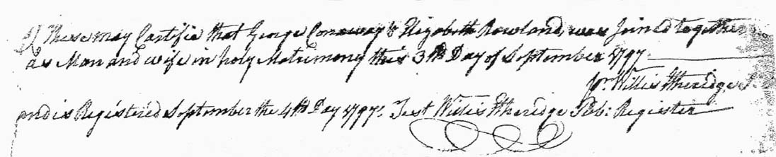
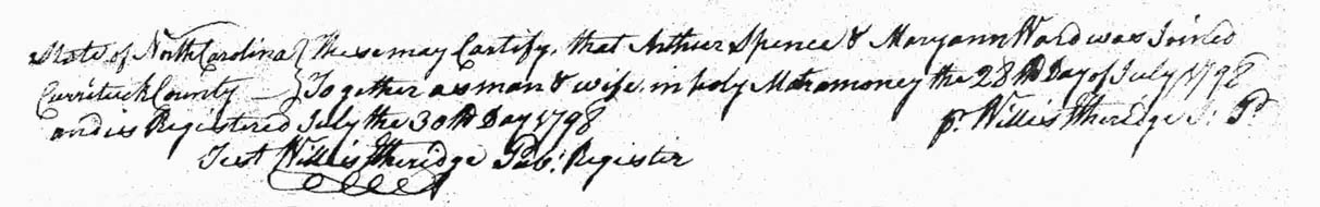