
Return to Currituck Co.
![]()
[Deed Book 7, pg. 3] July 5, 1793 - Samuel SALYEAR JUN.sold to William SNEEDAN, both of Currituck Co., for 50 shillings, 50 acres of land and marsh in the sand banks by PETERIDGE. Witnesses, Jesse TAYLOR, Polley SALYEAR; Registered, November 8, 1793
[Deed Book 7, pg. 3-4] Nov. 9, 1793 - I William GRAY for and in consideration of the sum of Ł300 paid to me by Robert BARNARD for a parcel of land which I bought of Joseph PELL date Oct. 13, 1791 known by name of HUGHS Place. Beginning on the North River percoason thence to the stream of Crooked run to Richard GREGORY house……………(smudged) containing 100 acres. Witness S. FEREBEE, Sarah PELL; Registered Dec. 9, 1793
[Deed Book 7, pg. 4-5] Oct. 31, 1793 - William RUSSELL sold to William GRAY for Ł145, a tract of land beginning at the edge of the main roade ajoining the land that was formerly John LINDSAYs various courses till it strikes a line of John WILLIAMS that he has lately purchased of the afsd. William RUSSELL then a Westerly course binding the said WILLIAMS line to the main roade then the roade to the first station containing 167 acres of land which this deed has a reference to a deed granted to the afsd. RUSSELL by Absolom DOLBY, John EVANS & Louisay EVANS also to a patent granted to the afsd. DOLBY in behalf of the afsd. Louisay bearing date October 24, 1786. Witness: Peter MORISSET, John CHANDLER, Benj. RUSSELL; Registered December 10, 1793
[Deed Book 7, pg. 5] Aug. 31, 1793 - William DUDLEY sold to John GUIN for Ł11 & 8 Shilings, 3 acres of land joining the land of Willis GUIN beginning at a pine on the South side of the plantation & running an East course down Jacob LITCHFIELDs line to an oak thence a North course across the land to an oak on Anne SMITHs line thence a West course to a gum on WILLIS GUIN line & from thence a South course to the first station. Witness: Malachi JONES, ????? GUIN, Cornilius JONES; Registered Dec. 10, 1793
[Deed Book 7, pg. 6-7] Sept. 27, 1793 - I Samuel SALYEAR Sheriff by order of a Writ of Fire Faces issued out of the Court of Please and Quarter Sessions which has ordered me out of the goods, chattles & lands of Henry ETHERIDGE Deceased and cause the sum of Ł16 19 Shillings & 3 Pence which lately was recovered by Joseph HARDING against the Administrator of ETHERIDGE. In obedience of Writ I did enter and take possession of a tract of land lying in Moyock Distract. Various courses to the old patent line formerly called Daniel McCOY’S thence to Willis BRIGHT’S line down his line to the Great Swamp along the swamp to the first station containing 100 acres, the land Henry ETHERIDGE dec’d bought of Parker SWINDEL. On Aug. 24, 1793 at the premises where & when John NORTHERN appeared & bid the sum of Ł15 and was the highest bidder. By virtue of Writ I Samuel SALYEAR Sheriff have granted said land unto John NORTHERN. Witness S. Hall; Registered Dec. 11, 1793
[Deed Book 7, pg. 7-8] Oct. 7, 1793 - I William RUSSELL of Carterite [Carteret] County for and in consideration of the sum of Ł60 paid to me by John WILLIAMS of Camden County for a peace of land lying in the County of Currituck. Beginning near the Branches of the Round Swamp various courses to Thos. JARVES, Blacksmith, line thence on the patent Absolom DOLBY patented in behalf of John EVANS & Louisey? his Wife various courses to contain 50 acres. Witness Joseph FEREBEE, James CRAB; Registered Dec. 12, 1793
[Deed Book 7, pg. 8] June 4, 1792 - I Mary SANDERSON for and in consideration of the sum of Ł20 paid to me by Thomas SANDERSON younger, doth demise grant & to firm let unto him all that messuage of land that was laid out and set apart for my 1/3 of my deceased Husband Jesse Sanderson plantation that lyes joining BERNARD’S & GREGORY’S. To have and to hold the land and premises for the term of my Mary SANDERSON natural life. Witness Hadley WOODHOUSE, Thos. POYNER; Registered Dec. 12, 1793
[Deed Book 7, pg. 8] Oct. 18, 1793 - Fanny PORTWOOD sold to John FISHER, both of Currituck, for Ł60, 311/2 acres of land in Cowinjock known by the name of Portwood's by Joseph SIMMONS, John STEVENS, James STEVENS. Witnesses, Jonathan TAYLOR, Saml ONEEL.; Registered December 12, 1793
[Deed Book 7, pg. 9] [no date] - Thos. IVES sold to School House Commissioners, for Ł30, 1/2 acre on Narrows Shore for the use of building a school house or school. Thirty years. /s/ Thomas IVES. Witnesses, Nathan THOMSON, Charles GRIGGS; Registered, December 13, 1793
[Deed Book 7, pg. 9-10] July 19, 1793 - I John CAPTS for and in consideration of the sum of Ł54 paid to me by Jesse SIMMONS Esq. for the same track of land John CAPTS had of Jesse SIMMONS containing 15 acres on the edge of Poiners Swamp. Witness Jas. BRAY, Edw. BUNNILL; Registered Dec. 13, 1793
[Deed Book 7, pg. 10-11] Dec. 25, 1793 - I Horatia BUSHELL of Norfolk County Virginina for and in consideration of the sum of Ł30 paid to me by Dempsey CASEY of the afsd. County & state for a piece of land in Currituck County joining Thomas CAMPBELL’S, Evan THOMPSON, Willis? Or Aaron BRIGHT’S formerly belonging to Solomon CAMPBELL containing 20 acres. Witness William GRANDY, Thos. ETHERIDGE; Registered Dec. 14, 1793
[Deed Book 7, pg. 11] Oct. 6, 1769 - Cornelius BERRY to Azrikam PARKER, Bond. Azrikam referred to as "planter"; bond of Ł200; Witness, Josiah NICHOLSON
[Deed Book 7, pg. 11-12] Nov. 1793 - I Anthony SIMMONS & Mary his Wife for and in consideration of the sum of Ł30 paid to me by Tulley WILLIAMSON for a track of land lying in the Back Woods. Beginning at a corner between Demcey BALLANCE & the heirs of Caleb WALKER dec’d various courses to Robert POYNER’S new patent line with his line various courses to the first station containing 30 Ľ acres, it being part of that tract of land taken up by John WALKER in the year 1713 and conveyed by John WALKER & Sarah his Wife to Thos. SIMMONS bearing date Oct. 6, 1718 thence descended to me Anthony SIMMONS. Witness Thos. Williams, Peter SLAUGHTER; Registered Dec. 16, 1793
[Deed Book 7, pg. 12-13] Sept. 30, 1790 - I Thomas BARNARD & Elizabeth my Wife for and in consideration of the sum of Ł78, 7 Shillings & 6 Pence paid to me by Jessey PERRY for a parcel of land on Currituck Sound being the residue of the former plantation that Peter LEATHFIELD owned, lived & died on. Beginning at the Sound side thence to the line of Margaret? JONES thence to the road called Shoar Road thence Joseph Sanderson patent line by various courses to edge of swamp from the Bridge out to the Eastward Swamp thence to Jesse PERRY’S line along his line to the first station containing 52 acres. Witness Thomas HEATH, Samuel BERNARD; Registered Dec. 16, 1793
[Deed Book 7, pg. 13] Nov. 26, 1793 - Patent for Jonathan TAYLOR. #145. For Ł10 per every 100 acres (?). 485 1/2 acres in Currituck by Nathan POYNER, on the side of William NICHOLSON's patent; Samuel EDY, Benjamin TAYLOR, by Thos. TAYLOR's patent, Edward TAYLOR's new patent. /s/ Richard Dobbs SPAIGHT by J. GLASGOW, Secretary.
[Deed Book 7, pg. 14] Dec. 14, 1793 - No. 146 - Know ye that we for and in consideration of the sum of 30 Shillings for every 100 acres hereby granted paid into our Treasury by Samuel SIMMONS for a tract of land containing 257 acres. Beginning in Willoughby DAUGE’S line and joining Samuel SIMMONS’S land various courses to James DAUGE’S patent various courses to the first station. Yielding and paying to us such sums as may be directed by our General Assembly. Provided Samuel SIMMONS shall cause this Grant to be Registered in the Registers Office within 12 months of date hereof. /s/ Richard Dobbs SPAIGHT; Registered March 3, 1794
[Deed Book 7, pg. 15] Dec. 14, 1793 - No. 147 - Know ye that we for and in consideration of the sum of 30 Shillings for every 100 acres hereby granted paid into our Treasury by Hilary SIMMONS for a tract of land containing 100 acres. Beginning at John GRAY’S, Mitchell SIMMONS, and Widow JARVES corner thence to the line that divids Thomas MERCER & Mitchell SIMMONS to Thomas MERCER’S corner then to Crabb Island patent various courses to John GRAY’S line along his line to the first. Yielding and paying to us such sums as may be directed by our General Assembly. Provided Hilary SIMMONS shall cause this Grant to be Registered in the Registers Office within 12 months of date hereof. /s/ Richard Dobbs SPAIGHT; Registered March 3, 1794
[Deed Book 7, pg. 15-16] April 2, 1715 - Know ye that we the Lords & Proprietors do hereby give & grant unto Andrew ETHERIDGE a tract of land containing 300 acres lying on the South side of Moyock Creek in the North West River. Being part of a tract of 650 acres formerly surveyed for John BENNETT and by him sold and assigned over unto ETHERIDGE. Beginning at a corner belonging to Thomas COX thence running down Moyock Creek various courses to the first, being due unto him for Transportation of 1 person for every 50 acres. Paying us yearly the rent of 1 Shilling for every 50 acres. Provided Andrew ETHERIDGE seat & plant within 3 years of the date hereof. /s/ C. EDEN; Registered March 3, 1794
[Deed Book 7, pg. 16] April 2, 1715 - Noble Henry Duke of Beadfore, know ye that we the Lords and Proprietors hereby give & grant unto Andrew ETHERIDGE a tract of land containing 25 acres being an Island in the Great Swamp at Currituck. Being due for the Transportation of 1 person for every 50 acres. Paying us yearly the rent of 1 Shilling for every 50 acres. Provided Andrew ETHERIDGE seat & plant within 3 years of the date hereof. /s/ C. EDEN; Registered March 4, 1794
[Deed Book 7, pg. 17-18] Nov. 22, 1793 - I Joseph BALLENTINE & Lovey my Wife for and in consideration of the sum of $150 paid to me by Solomon COX for a tract of land lying about 2 miles from Moyock Mill in a place called the Light Swamp. Beginning at Maxamilion BOWREN’S corner various courses to a line formerly called Burnham’s line along this line to BOWREN’S line thence to the first station containing 100 ˝ acres. Witness Lewis COX, Thos. ALLERSON; Registered March 4, 1794
[Deed Book 7, pg. 18] Feb. 13, 1793 - I Richard NICKEN Planter, & Elizabeth his Wife for and in consideration of the sum of Ł20 paid to me by George FORKER Blacksmith, for a parcel of land near the Great Swamp Bridge. Beginning at the South East corner of George FORKERs land various courses to John NORTHERN’S line thence to Susannah MAYS line to FORKERS line to the first station containing 10 acres. Witness David MINTEZ, Marmeduke COX; Registered March 5, 1794
[Deed Book 7, pg. 19-20] Oct. 1, 1751 - I Evan MILLER SEN. for and in consideration of the Natural Love and affection which I bear unto my Son Evan MILLER JUN. have granted unto him half a tract of land the whole tract bounded as follows: Beginning at John BALANCEs corner various courses to PRESCOTs corner along his line thence to a corner of PRESCOTs in CHITTOMs line along his line various courses to first station containing 238 acres. Witness Saml. SIMMONS, Thos. BURGES, Solomon JARVES; Registered March 8, 1794
[Deed Book 7, pg. 20-21] Jan. 7, 1794 - I John ANSELL & Betsey my Wife for and in consideration of the sum of 1000 Spanish Milled Dollars paid to me by Capt. Andrew BATES for a parcel of land. Beginning at the mouth of a Creek adjacent to John BATES wharf land running up to the crossway thence up Willis BALANCEs line to John BATES land along his line to Henry BALLENTINs line thence to the North West River down the River to the mouth thereof thence various courses along Tulls Creek Bay to the mouth of Tulls Creek up the Creek to the first station containing 300 acres. Witness Saml. JASPER, Lovey JASPER; Registered March 19, 1794
[Deed Book 7, pg. 21-22] Feb. 13, 1794 - I John EVANS & Lovey his Wife for and in consideration of the sum of Ł142 paid to me by Peter PADRICK for a tract of land lying on Powels Point. Various courses to the new line of William MELSON with said line to the corner of said line and John EVANS line with his line various courses to the first station containing 100 acres. Witness Nathan HALL, S. HALL; Registered March 20, 1794
[Deed Book 7, pg. 22] Jan. 14, 1794 - George COFFEE sold to Willis GALLOP for Ł5 Lawfull Money. "...Land lying & Situate on Currituck Banks, Begining at John GALLOP's line Runing with Said line to the Sea Side thence a Northerly course to contain 25 acres thence a westerly Course to the Sound thence along the Sound to the first Station..." Witnesses: Thos. DOUGH, A.D. GREVES; Registered March 20, 1794.
[Deed Book 7, pg. 23] Sept. 26, 1793 - Mary SANDERSON for the paternal affection that I bear to my Son Jasper TAYLOR give one negro man called Dave as well as the sum of 10 Shillings. Witness: Hadley WOODHOUSE, Hezikiah WOODHOUSE; Registered March 20, 1794.
[Deed Book 7, pg. 23] [no date] Pleasant YOUNGHUSBAND, of Richmond, Va. and executor of Thomas YOUNGHUSBAND, deceased, sold to Jonathan TAYLOR of Currituck County, for 100 Spanish milled dollars, 50 acres on Mackies Islandon the north side of Currituck Bay. Borders Peter POYNER, Willoby WHITE. Witnesses, Hosea BALL, John DEAN. Registered March 20, 1794
[Deed Book 7, pg. 24] Feb. 1794 - I Timothy ETHERIDGE for and in consideration of the sum of Ł10 paid to me by Willoughby DAUGE for a messuage of land. Beginning in Phillip DAUGE’S line along his line & WILLOUGHBY DAUGE’S line then to Willoughby DAUGE’S line & Joseph GREGORY’S line along his line to the first station containing 5 acres, being part of the tract of land I now live. Witness S. FEREBEE, Thos. P. WILLIAMS; Registered March 21, 1794
[Deed Book 7, pg. 24] Nov. 18, 1793 - I James DAUGE for and in consideration of the sum of Ł25 paid to me by Gideon GREGORY for a track of land. Beginning on the North side of PERKINS old plantation Westerly to HUTCHINS line various courses to the first station containing 25 acres. Witness Thos. SANDERS, Cloey GREGORY; Registered March 21, 1794
[Deed Book 7, pg. 25-26] Dec. 18, 1793 - Josiah NICHOLSON sold to Willougby DAUGE, both of Currituck, for Ł35, 250 acres in Currituck by Lemuel WILSON, Tatum WILSON, Willougbhy BROOKS, Leml WILSON. Witness, Chloe DAUGE, S. FEREBEE; Registered March 22, 1794
[Deed Book 7, pg. 26-27] Feb. 1, 1794 -I William WICKER SEN. for and in consideration of the sum of Ł18 paid to me by Henry WHITE JUN. for a piece of land & marsh lying on Indian Creek various courses containing 39 Ľ acres. Witness Samuel JASPER; Registered March 22, 1794
[Deed Book 7, pg. 27] Oct. 8, 1793 - I Joshua HARRISON & Aliff for and in consideration of the sum of Ł24 paid to me by William CARTER for a piece of land on Powels Point joining the land of Richard DOUGHs. Beginning various courses along the North side of the Swamp to Joshua HARRISON’S line then to the corner of HARRISON and Rich’d DOUGH down DOUGH’S & HARRISON line to the road running with the road to the first station including 12 acres. Witness Absolom GREVES, Ann DOUGH, Sam. GREGORY ; Registered March 25, 1794
[Deed Book 7, pg. 28] April 26, 1762 - I William MANN SEN, planter, am held & firmly bound unto Thomas ADDISON, waterman in the just sum of Ł100. The condition of the obligation is such that William MANN shall make over to Thomas ADDISON a good right & Title to a peace of upland excluding marsh containing 50 acres on the far end of Croatan called Spencers Point in Tarrel County. Witness Stephen WESTCOT, Abel LESTER
Aug. 9, 1766 - From Thomas ADERSON by Power of Atty. to Edward SPENCER and of Edward SPENCER do assign over my Right & Title of this within Bound unto Solomon ASHBEE; Registered March 25, 1794
[Deed Book 7, pg. 28-29] Dec. 1784 - I John MERCER & Edward TAYLOR are held & firmly bound unto Thomas JARVES Sheriff in the full & just sum of Ł5000. The condition of the obligation is such that John MERCER do well and truly settle and account with Thomas JARVES for all the moneys fees that may arise by virtue of his being appointed as Deputy Sheriff. Witness Saml. SALYEAR; Registered March 25, 1794
[Deed Book 7, pg. 29] Feb. 11, 1794 - I William BEASLEY & Ann BEASLEY Planters for and in consideration of the sum of Ł20 paid to me by John NORTON Planter, for a tract of land situate on Roanoak Island. Beginning on Stephen BEASLEYs line then to Stephen WESKETTs line with his line to Tart ETHERIDGE with his line to first station containing 20 acres. Witness Stephen WESKETT, Stephen FLETCHER; Registered March 27, 1794
[Deed Book 7, pg. 30] Feb. 17, 1794 - William MUNCRIEF and his wife Martha, of Currituck Co., sold to William ROBINSON of Princess Anne, Virginia, for $500.00, 100 acres of land by the name of William MUNCRIEF's plantation, bounded by THOMSON's line. Witnesses: William TAYLOR, William THOMSON; Registered March 29, 1794
[Deed Book 7, pg. 30-31] Dec. 7, 1789 - I Stephen BEASLEY for and in consideration of the sum of Ł15 paid to me by Lazarus LINTON for a messuage of land on the North East side of Ronoak Island. Beginning on Solomon ASHBEEs line the quantity of 83 it being the Eastermost part of the land Jacob BEASLEY dec’d gave to his 3 Sons, Jacob, Stephen & Weightman the land bound on N.E., N.W., & S.E. by ASHBEE & on S.W. by Weight BEASLEYs line as much as shall contain 83 acres. Witness Henry BEASLEY, Weightman BEASLEY, Henry BEASLEY; Registered March 27, 1794
[Deed Book 7, pg. 31-32] Jan. 7, 1791 - I Henry BEASLEY of Roanoak Island for and in consideration of the sum of Ł25 paid to me by Stephen BEASLEY for a tract of land lying on Roanoak Island. Beginning at the corner of Tart ETHERIDGEs line running to Abel ASHBEEs line along his line to MANNs line along his line to William BEASLEYs line along his line to the first containing 30 acres. Witness Wateman BEASLEY, Reuben ETHERIDGE, Stephen FLETCHER; Registered March 27, 1794
[Deed Book 7, pg. 32-33] Jan. 18, 1794 - I Caleb COX Planter, & Nancy his Wife for and in consideration of the sum of Ł60 paid to me by Thomas COX Planter, for a parcel of land about 2 miles West of Moyock Mill. Beginning at a corner in Thomas COXs line thence to a corner of Caleb ETHERIDGE JUN. line along his line to Luke BERNARDs line which divids his and Caleb ETHERIDGEs land along BARNARDs line to a corner in Thomas COXs line along his line to the first containing 60 acres. Witness David MINTZ, Edw. DOUGHTY, Luke BERNARD; Registered March 28, 1794
[Deed Book 7, pg. 33] Jan. 10, 1794 - I Jonathan LINDSEY for and in consideration of the sum of Ł100 paid to me by James HUMPHREY for a negro man named of Sam. Witness Thos. JARVES SEN., Thos. JARVES; Registered March 28, 1794
[Deed Book 7, pg. 33-34] Feb. 25, 1794 - I Jesse SIMMONS & Elizabeth my Wife for and in consideration of the sum of Ł79 5 Shillings paid to me by James PHILLIPS Esq. for a parcel of land. Beginning at Jeremiah PERKIN & BELLs corner along BELLs line to a corner in James POYNERs line along his line to John SIMMONS line down his line to John PERKINS line along his line to Jeremiah PERKINS corner his line to the first containing 101 ˝ acres. Witness Andrew DUKE, Moses CAPTS; Registered March 28, 1794
[Deed Book 7, pg. 34-35] Jan. 28, 1794 - I Jesse SIMMONS & Elizabeth my Wife for and in consideration of the sum of Ł100 Cash paid to me by Moses CAPTS for a piece of land. Beginning on the Bay side Mason BRIGHTs layn thence to William BARNARDs line various courses to the first containing 50 acres. Witness George FORQECHER?, John CAPTS; Registered March 28, 1794
[Deed Book 7, pg. 35] [no date] - John COCKTON arrives at Norfolk in Virginia June 13, 1771 from Westermoreland County in England, Deceased Dec. 22, 1788 in Currituck County. His Daughter Barbery deceased May 31, 1790, & his Daughter Mary deceased Jan. 21, 1794. Registered March 28, 1794; Willis Etheridge Pub Register [This is a VERY interesting item to be found in a deed book.]
[Deed Book 7, pg. 35] Dec. 12, 1789 - I Weightman BEASLEY for and in consideration of the sum of Ł12 10 Shillings paid to me by Lazarus LINTON for a piece of land on the North East side of Ronoak Island. Beginning on Solomon ASHBEEs line bounded by ASHBEEs line on the N.W. on my line on the N.W. the land I lately purchased of Stephen BEASLEY on the S.E. on ASHBEEs line on the S.W. Jacob BEASLEYs line to contain 58 acres. Witness Henry BEASLEY, Mary ASHBEE, Stephen BEASLEY; Registered March 28, 1794
[Deed Book 7, pg. 36] Feb. 12, 1794 - I Asa LEE & Mary his Wife for and in consideration of the sum of 90 Silver Dollars paid to me by William MEHAINS for a presell of land joining on the Sound, being part of the land which Noah PARR sold to Caleb LEE & joining the land of William SHERGOLD. Beginning at the Sound the division line between MEHAINS & the orphan of James LEE thence to the division line between MEHAINS & the orphan of Francis WILLIAMSON thence at the corner of William SHERGOLDs fence then East to the Sound side along the Sound to the first containing 25 acres. Witness James PHILLIPS, Griffeth DAUGE; Registered March 31, 1794
[Deed Book 7, pg. 36-37] Feb. 21, 1794 - I Dorastus WILLIAMS & Fawnia my Wife for and in consideration of the sum of Ł60 paid to me by James McCLANEN for a messuage of land. Beginning in Thomas MUNCREEFs line various courses to BALLENTINE line various courses to the first containing 35 acres & 17 poles. Witness Benj. BRICKHOUSE, Enoch McCLANEN; Registered March 31, 1794
[Deed Book 7, pg. 37-38] Dec. 30, 1793 - Zorobable HARRISON & Juliann his Wife for the consideration of Ł165 paid to me by Josiah CURLING for a tract of land on Powels Point containing 60 acres. Beginning various courses to George DAWEST line with his line to John HILLs line with his line to Laben THOMAS line with his line to the first. Witness Jacob CARTWRIGHT, Mecaiah BEELS, Abraham BROWN; Registered March 31, 1794
[Deed Book 7, pg. 38] Sept. 26, 1793 - I Mary SANDERSON for and in consideration of the paternal affection I bear to my Daughter Sarah SANDERSON as well as the sum of 10 Shillings paid on behalf of Sarah SANDERSON, I have give & granted to her a negro man called Bob. Witness Hadley WOODHOUSE, Hezekiah WOODHOUSE; Registered March 31, 1794
[Deed Book 7, pg. 38-39] Feb. 18, 1794 - John SLEIGHT & Isaiah PARR for the priviledge of a road thro his land agree to find William ROBINSON timber out of their swamp for the use of his plantation, as long as the swamp last provided ROBINSON dose not make use of any standing timber or timber along the main bridges nor to sell or dispose of any kind of timber to any person whatsoever. Witness Wm. TAYLOR, Wm. THOMSON; Registered March 31, 1794
[Deed Book 7, pg. 39] William NICHOLSON's Patent. William NICHOLSON's patent, apparently first granted by the Duke of Beaufort in 1714, was registered in Currituck County in 1794. It is likely it was registered then as land title was recognized from the colonial era after independence, and to be recognized the patent needed to be registered. It was 486 acres of land; joins on Thomas TAYLOR's line; measures the land in question in "poles"; borders Hosea BALL's plantation (most likely a description that applies to 1794). /s/ C. EDEN, Thomas BAY (?), N. CHERVIN, Wm REED, C. GALE, Francis FOSTER (?). Copy J. GLASGOW, Secretary. Registered May 31, 1794. Attest, Willis ETHERIDGE
[Deed Book 7, pg. 39-40] April 7, 1794 - I William HUNNINGS for and in consideration of the sum of Ł100 paid to me by Alexander L. WHITEHALL for a parcel of land adjoining the land of Asa PARSONS. Beginning at the head of the old division line between WILLIAM HUNNGS along division line on the West Side Fleirts Creek down Creek to the swamp binding the swamp to Joseph McCORNARY line with his line to William RASELD corner with his line down the Beaver Dam Swamp to the first containing 115 acres. Witness Saml. SALYEAR JUN., Thos. SANDERSON; Registered Sept. 14, 1794
[Deed Book 7, pg. 40-41] Mar. 28, 1793 - I William MILLER & Prisilla MILLER for and in consideration of the sum of Ł11 paid to me by John FLOWERS for a parcel of land lying on Kinnekeet. Beginning near the main road thence running East to Farrow FARROWs line along his line to William MILLERS corner then to the Sound running with the Sound to the first, agreeable with the courses of Jacob FARROW SEN. patent containing 50 acres. Witness John PEEL, Farrow FARROW; Registered June 23, 1794
[Deed Book 7, pg. 41-42] Mar. 1, 1794 - I Samuel JASPER for and in consideration of $40 paid to me by Benjamin HEWITT for a piece of land lying on Knots Island. Beginning at the corner of Henry WHITE SEN. land various courses along WHITEs line to the first containing 4 ľ acres. Witness John KEMP?, Southward WATERFIELD; Registered June 24, 1794
[Deed Book 7, pg. 42-43] Mar. 11, 1794 - I William McHAINS & Isabel my Wife for and in consideration of the sum of 100 Spanish Milled Dollars paid to me by John BRYANT for a parcel of land. Beginning on the Sound at a division line between William McHAINS & the orphans of James Lee to the head line division line between McHAINS & the orphans of Francis WILLIAMSON thence to William SHERGOLD fence thence East to the Sound side along the Sound to the first containing 25 acres. Witness Jesse SIMMONS, Edney SIMMONS; Registered June 24, 1794
[Deed Book 7, pg. 43-44] October 9, 1793 - William MEKINS of Kennekeet on Hatteras Banks sold to Farrow [Pharoah] FARROW, planter of the same place, for 5 Spanish Milled Dollars, one acre of land on Kennekeet joining Joseph WILLIAMS and Jacob FARROW. Witnesses: Gideon DANIEL, James MEEKINS. Registered June 25, 1794
[Deed Book 7, pg. 44] May 2, 1794 - Willis POWERS, planter of Currituck Co. sold to Peter CULPEPPER of Currituck Co., for 4 dollars, a tract of land in Currituck County in the Back Woods near the Virginia line and joining Edwd. DOUGHTY's new road, and Jeremiah SEXTON's line, containing 80 square rods. /s/ Willis POWERS, Cloe [x her mark] POWERS. Witnesses: George [x] POWERS, David MINTZ, Edwd. DOUGHTY.
[Deed Book 7, pg. 45] Apr. 5, 1794 - John THOMSON sold to Daniel DUNTON, both of Currituck, for 100, 80 acres in Currituck on Cowinjock Bay by John DOXEY, Armistead SOLES. /s/ John THOMSON Andey THOMSON. Witness: Josiah NICHOLSON, Rebeckah NICHOLSON; Registered June 25, 1794
[Deed Book 7, pg. 46] May 26, 1794 - I Willoughby DAUGE for the consideration of 30 Spanish Milled Dollars paid to me by Nathan & Spence HALL for a piece of land & marsh. Beginning on John NORTEN & joyning on Panters Creek & Padricks Creek containing 234 acres. Witness Jesse SIMMONS, Joseph W. CHRISTOPHER; Registered June 25, 1794
[Deed Book 7, pg. 46-47] Feb. 22, 1794 - I Richard NICKEN Planter, & Betsey my Wife, late of the County of Currituck, for the consideration of $300 paid to me by Caleb COX for a parcel of land between Moyock Mill & Great Swamp Bridge. Beginning near the South end of Thomas ALLISONs line a corner between ALLISON and Richard NICKEN to a corner between NICKEN & John NORTHERN Esq. thence to George FORKERs corner to another corner of FORKERs land to a gum standing near FORKERs house & in the City line, thence to the Great Swamp thence to Wolf Pit Ridge continue to the first containing 160 acres. Witness Thos. COX, Lewis COX, Charles GRIMES, Thos. ELLISON; Registered June 26, 1794
[Deed Book 7, pg. 47-48] May 26, 1794 - I Jesse SIMMONS for the consideration of Ł4 paid to me by Simon MATTHIAS for a parsel of land joining the land whereon MATTHIAS lives. Beginning at Matthias HOLSTEADs corner various courses to first containing 47 Ľ acres. Witness James BRAY, Edney SIMMONS; Registered June 26, 1794
[Deed Book 7, pg. 48] Feb. 1, 1794 - I William WICKER for the consideration of Ł16 paid to me by Samuel JASPER for a piece of land situated on Indian Creek. Beginning at the mouth of a ditch the West side of the Creek near the head of the old cross way that divides the land of JASPER & Michael WATERFIELD various courses to the South side of Rice EVANS Nole of land thence to a ditch that divides the Indian Creek land from Mackies Island various courses to the first containing 39 Ľ acres. Witness Henry WHITE JUN.; Registered June 26, 1794
[Deed Book 7, pg. 48-49] Mar. 31, 1794 - I William ETHERIDGE for the consideration of Ł6 paid to me by Abel ASHBEE for a parcel of land lying on the North Banks. Beginning at the Sound Side JACOXES? Line running East the course of JACCES line to the Sea various courses of the Sea to Henry PADRICKs line West along PADRICKs line to the Sound various courses of the Sound to the first containing 60 acres. Witness Lazarus LINTON, Barnabe ETHERIDGE; Registered June 28, 1794
[Deed Book 7, pg. 49-50] Feb. 19, 1794 - I Thomas BEST for the consideration of $25 paid to me by Levin TWIFORD for a parcel of land situated on the North Banks. Beginning on Daning Ridge Pond Side East course across to Kityhawk Ridge along the Ridge to John LUARKs line thence his line to Daning Ridge Pond up the Pond to the first containing 50 acres. Witness Peter BRICKHOUSE, Ezrnah BRICKHOUSE; Registered June 28, 1794
[Deed Book 7, pg. 50] Nov. 30, 1793 - Robbard WILLIAMS of Cape Hatteras Banks in Currituck Co. sold to Ezekiel HOOPER, for Ł50 lawful money, a parcel of land lying on Kinnekeet beginning at the Landing Creek and running to a post in the old field near the Grave Yard, from said post along the road to a post at William MICKINS' line...., containing 50 acres. Witnesses: John PEEL, John FLOWER. Registered: June 28, 1794
[Deed Book 7, pg. 51] May 20, 1794 - I Asa ETHERIDGE for the consideration of Ł300 paid to me by Spence HALL for a track of land lying on Powels Point, various courses to Samson ETHERIDGEs land so far as will include 60 acres then to HALL line down his line to the swamp various courses of the swamp to the first containing 60 acres. Witness Nathan TATEM, Thos. WILLIAMS; Registered June 28, 1794
[Deed Book 7, pg. 51-52] March 22, 1794 - I Thomas FEREBEE & Elizabeth his Wife for the consideration of Ł18 & 6 Shillings paid to me by William FREMAN for a tract of land containing 8 acres beginning at Moyock Creek. Witness Hez. PURRINGTON, Charles BRIGHT; Registered June 30, 1794
[Deed Book 7, pg. 52-53] Nov. 20, 1793 - William MEEKINS of Cape Hatteras Banks in Currituck Co. sold to Robbard WILLIAMS, for Ł50 lawful money, a tract of land lying on Kinnekeet beginning at William MEEKINS' creek and running to Robbard WILLIAMS' line, then to the head of Joseph WILLIAMS, dec'd., creek, containing 50 acres. Witnesses: John PEEL, John FLOWER. Registered: June 30, 1794
[Deed Book 7, pg. 53-54] March 10, 1794 - I John WORMINGTON & Mary his Wife for the consideration of 30 Silver Dollars paid to me by Joseph BALLENTINE for a parcel of land. Beginning at the Widow STANDLEYs land various courses to Charles BRIGHT & Peter BALLENTINE land East binding on BALLENTINE line various courses to the first containing 20 acres. Witness Caleb WILSON, Thos. FEREBEE; Registered June 30, 1794
[Deed Book 7, pg. 54] March 29, 1794 - Capt. Samuel WILLIAMS and Anna (?) his wife, sold to John DOXEY, all of Currituck, for 300 silver dollars, 68 acres of land in Currituck by CAMPBELL's line; John PERKINS; Jeremiah PERKINS; Wm BELL; KINSEY's line. /s/ Saml. WILLIAMS, Anna (Anne?) WILLIAMS. Witnesses, John WILLIAMS, Daniel DUNTON; Registered July 8, 1794
[Deed Book 7, pg. 55-56] May 20, 1794 - I Spence HALL for the consideration of Ł300 paid to me by Asa ETHERIDGE for a tract of land. Beginning on Tarkeln Point near Currituck Sound running up a Creek known by the name of Daviss Creek various course to Jesse DUKES line along his line to Thos. GREGORIES line down his line to the Sound side various courses of the Currituck Sound to the first containing 64 acres. Witness Nathan HALL, Thos. WILLIAMS; Registered July 8, 1794
[Deed Book 7, pg. 56] April 12, 1788 - I Richard ETHERIDGE for the consideration of Ł13 all ready to me paid by my Son Henry ETHERIDGE have sold unto him some part of my household goods and some sheep, 1 hand mill, 1 great squar table, 1 iron pot & pot hooks, 1 iron skillet, 1 linning wheel, 1 gallon pewter bason, 1 fether bed bead stead and furniture & 5 head of sheep & their increase. Witness Aaron BRITE, Anne BRITE, Sarah BRITE; Registered April 12, 1788
[Deed Book 7, pg. 57-58] March 6, 1794 - I Joseph MORGAN & Sucky MORGAN of Cape Hatteras Banks for the consideration of Ł9 paid to me by Pharrow FARROW for a tract of land near the Cape. Beginning on the plains then running on the South side of the head of Hill Creek running down the Creek to the Sound side along various courses of the Sound various courses to the beginning so that be completely 50 acres, it being part of a patent No. 312 that was granted to Henry BLACK May 5, 1769. Witness William MILLER, Francis FARROW, Francis JACKSON; Registered July 8, 1794
[Deed Book 7, pg. 58] June 14, 1793 - Joseph GRAY sold to Benjamin TAYLOR for 175 Spanish milled dollars, one negro named Ned (?). Witnesses Thomas ECCLESTON, Thos GREY; Registered July 8, 1794
[Deed Book 7, pg. 58-59] Oct. 14, 1793 - I Henry CULPEPPER for the consideration of Ł11 paid to me by Nicholas CULPEPPER JUN. for a tract of land. Beginning at Thos. CULPEPPER North corner running westward to David CREEKMORs line various courses to the first 50 acres. Witness Peter CULPEPPER, Mary CULPEPPER; Registered July 9, 1794
[Deed Book 7, pg. 59-60] Dec. 18, 1793 - I Mordicai BEASLEY, Lydia BEASLEY & Bridgett BEASLEY for and in consideration of Ł30 paid to us by William BEASLEY for a parcel of land containing 2 acres. Witness Cornelius BEASLEY, Taylor BEASLEY; Registered July 9, 1794
[Deed Book 7, pg. 60-61] 1794 - I George FISHER for the consideration of the Natural Love I bear unto my Son William FISHER & also for the better maintenance preferment of him I hereby grant unto him a messuage of land whereon I now live. Various courses to PARKERs line near Ľ mile thence to first containing 30 acres. Witness Samuel ????? , Adam POYNER; Registered July 9, 1794
[Deed Book 7, pg. 61] April 10, 1794 - I Matthias TOWLER for the consideration of Ł10 paid to me by Peter BRICKHOUSE for a parcel of land on the North Banks containing 50 acres. Beginning at Dancing? Ridge Pond then running down Kittehawk Ridge to the first. Witness Leven TWIFORD, William DOWDY; Registered July 10, 1794
[Deed Book 7, pg. 61-62] 1794 - I William BEASLEY of Ronoak Island for and in consideration of 10 ˝ Spanish Miled Dollars paid to me by Stephen BEASLEY for all the priviledge that was given by my Grandfather Stephen WESTCOTT to me in the marsh on Ronoak Island known by the Back Marsh. Witness Lazarus LINTON, Henry BEASLEY; Registered July 10, 1794
[Deed Book 7, pg. 62-63] April 8, 1794 - Randolph JONES, SR. sold to Thos. JARVIS, ship carpender, both of Currituck, 2 acres of land in Currituck situate and lying on WinMill Shore. Witnesses, Thos TAYLOR, Edwd. TAYLOR; Registered July 10, 1794
[Deed Book 7, pg. 63] May 26, 1792 - I John SKINNER Marshall for North Carolina District, received of Mr. Griffin DAUGE the sum of $117.75 for 2 negroes Solomon & Esther, which negroes was taken by Execution issued from District Court held at Newbern for North Carolina District from John HUMPHRIES Esq. & sold at Publick Auction & Griffin DAUGE being highest bid. Witness Thomas JARVES; Registered July 10, 1794
[Deed Book 7, pg. 63] May 28, 1794 - I Thomas HEATH for the consideration of Ł50 paid to me by Daniel LINDSEY for 1 negro boy called Jack about 10 years old. Witness Tulley DAUGE, Joseph K. CHRISTOPHER; Registered July 10, 1794
[Deed Book 7, pg. 64] Feb. 25, 1794 - I Thomas HALL & Betsey my Wife for the consideration of $300 paid to me by Henry GUY for a parcel of land. Beginning at Bay side CALLIS line along his line to the old main road along road to WARDS line down the center of Branch to the River so binding on River to the first containing 70 acres. Witness Thomas TILLETT; Registered July 11, 1794
[Deed Book 7, pg. 65] Dec. 17, 1793 - Richard DOBBS to Adam POYNER and Thos. TAYLOR, for 30 shillings for every hundred acres, 165 1/2 acres bounded by Wm SMITH, Edward TAYLOR, and Joseph TAYLOR. /s/ J. GLASGOW, Secretary. Registered, August 30, 1794
[Deed Book 7, pg. 65] June 27, 1794 - Agreeable to a Commission to me directed, John NORTHERN have privately and apart examined Nancy COX and concerning her consent of the within conveyed land and premises who did acknowledge that she freely & of her own consent without fear or compulsion of her Husband Caleb COX. /s/ John NORTHERN J.P.; Registered Aug. 30, 1794. [This probably refers to the land mentioned in Deed Book 7, pg. 32-33]
[Deed Book 7, pg. 66-67] July 23, 1793 - I Joseph GAMEWELL & Esther my Wife for and in the consideration of Ł8 paid to me by Samuel GREGORY for a parcel of land on Powels Point. Beginning at Samuel GREGORYs fence various courses to the first containing 2 acres. Witness S. HALL, Benj. SIKES, Thos. DUDLEY; Registered Sept. 12, 1794
[Deed Book 7, pg. 67-68] Aug. 27, 1794 - I Samuel SALYEAR Sheriff by virtue of a Writ of Feirs Faceis issued out of Court of Please & Quarter Session directing me to cause to be made out of the goods chattles & lands of Hezekiah PURRINGTON & Drusilla PURRINGTON & if not sufficient of theirs to be found of Joseph FEREBEE the sum of Ł43 3 Shillings & 5 Pence 3 Farthings which lately recover by John SYMMONDS against them. In obedience of Writ I did enter and take into possession a tract of land known by the name of HAYMANs Place whereon Haymonds Widow now lives. Situate in the District of Moyock bounded by the lands of Marmeduke COX, John NORTHERN, Joseph MAY & Thos. COX. After public notice at Publik Vendue when & where Joseph FEREBEE Esq. appeared & bid Ł67 which was highest bid. By virtue of Writ I Samuel SALYEAR Sheriff have granted & conveyed unto Joseph FEREBEE said land. Witness Hilary SIMMONS, Caleb WIKER?; Registered Sept. 15, 1794
[Deed Book 7, pg. 68-69] March 14, 1794 - I Hilary & Mitchel SIMMONS for the consideration of Ł12 paid to us by John GRAY for a piece of Cypress Swamp being part of the land bout of T. YOUNGHUSBAND & part out of Hilary SIMMONS new Patent. Beginning at the edge of the swamp side not far of the old Bridge various courses to Widow JARVIS line along her line to John GRAYs line beginning tree of Hilary SIMMONS new patent along GRAYs line various courses to the first for 24 acres. Witness Rich. HOLSTEAD, William HOLSTEAD; Registered Sept. 15, 1794
[Deed Book 7, pg. 69] June 14, 1794 - John SANDERSON sold to Lemuel SANDERSON, both of Currituck, for Ł200, Negro girls called Sarah and Pleasant and one Negro boy called Dick. Witnesses, Thos. SANDERSON, Benjamin TAYLOR, Alex. WHITEHALL and Saml. SALYEAR; Registered September 16, 1794
[Deed Book 7, pg. 70-71] Aug. 26, 1789 - I Kedar MULDER Sheriff by virtue of a Writ of Fiere Facis issued out of the Court of Pleas & Quarter Sessions directing me to cause out of the goods chattles & lands of Thomas HAYMAN Esq. deceased in the hands of John SIMMONS Executor, you cause the sum of Ł17 8 Shillings & 8 Pence lately recovered by James PHILLIPS against him. In obedience of Writ I did enter & took into possession a tract of land known by the Light Swamp in the District of Moyock. Bounded by the Orphans of Thos. WHEATLEY, Caleb COX, Thos. COX, Solomon WILSON, John BRIGHT, Parker SWINDAL, Francis Williamson BRIGHTS, Abel ETHERIDGE & Joseph VALLENTINE. At Publick Vendue when & where Joseph FEREBEE Esq. did appear & bid Ł25 for the messuage of land. I Kedar MULDER Sheriff by virtue of Writ did grant the land unto Joseph FEREBEE. Witness Hilary SIMMONS, James PHILLIPS; Registered Sept. 16, 1794
[Deed Book 7, pg. 71-72] May 30, 1792 - I Thomas P. WILLIAMS Sheriff by virtue of a Writ of Firi Facias issued out of the Court of Currituck which ordered me out of the goods chattles & lands of John Hayman deceased to cause the sum of Ł13 17 Shillings which lately was recovered by Dory DAUGE assignee of James SYMMONS. In obedience of Writ I did enter and take possession of a tract of land containing 101 acres situate in Moyock being part of a tract patened by Jacob GOODMAN & sold by John NORTHERN Esq. to John HAYMAN commonly called Light Swamp. Beginning at a corner between the premises & Luke BARNARD then to Solomon COX JUN. line to a corner between Solomon COX & Joseph FEREBEE then to Moses FREEMANs line along his line to Haymans old line to the first. I did expose the land for sale where & when Edward DOUGHTY did appear & bid 3 Shillings per acre & was highest bidder. By virtue of Writ I Thomas P. WILLIAMS have conveyed unto Edward DOUGHT the said land. Witness Luke BARNARD, Thos. COX, David MINTZ; Registered Sept. 16, 1794
[Deed Book 7, pg. 72-73] May 29, 1794 - I Samuel SALYEAR Sheriff by order of 2 Writs of Fire Facis issued out of Court House commanding me that of as much of the lands & tenements of Solomon BENNETT deceased in the hands of Jonathan WILLIAMSON Adm. To cause the sum of Ł16 & 2 Shillings which out of 2 suits brought by BARTIE & WILSON & Demsey NORTHERN against WILLIAMS was recovered. In obedience of Writs I did enter & take into possession a tract of land beginning on Moyock Creek joining Matthew BENNETTs land binding on his land to Joseph BALLENTINE land along his line to Moses BENNETTs land binding on his land to Moyock Creek along the Creek to the first containing 13 ˝ acres. July 11, 1794 land was exposed for sale where & when Caleb WILSON did appear & bid the sum of Ł17 and was highest bid. By virtue of 2 Writs I Samuel SALYEAR Sheriff have granted & convey said land unto Caleb WILSON. ; Registered Sept. 17, 1794
[Deed Book 7, pg. 73] May 15, 1794 - Lemuel SANDERSON & Sabria? his wife sold to Saml. SALYEAR, JUNR., all of Currituck, for Ł60, for 50 acres of land on the limit of Narrows Shore by Saml. SALYEAR, SEN., Peter LITCHFIELD, John BARRETT. Witness: William WOODHOUSE, Jesse TAYLOR; Registered September 17, 1794
[Deed Book 7, pg. 74] Sept. 30, 1793 - I Asa LEE for the consideration of Ł53, 6 Shillings & 8 Pence paid to me by John WALMSLEY for a parcel of land called the Long Field being at the head of John WALMSLEYs Mill Pond. Beginning at Saml. LEEs line then to Elanor ETHERIDGE & William BLOUNTs lines containing 50 acres. Being taken out of a patent containing 200 acres granted to Nehemiah HEATH date Dec. 1, 22 year of his Majestys reign. Witness Willis BALLANCE, Frankey WRIGHT; Registered Sept. 18, 1794
[Deed Book 7, pg. 75] April 2, 1794 - I Joseph GRAY for the consideration of Ł55 for a negro boy named March. Witness Thos. BERNARD, Randolph JONES, Thos. GRAY; Registered Sept. 18, 1794
[Deed Book 7, pg. 75-76] Aug. 27, 1794 - I John WALMSLEY for the consideration of Ł15 paid to me by Thomas WILLOUGHBY for the rights to ˝ the land held under patent dated Nov. 13, 1790 for 161 acres, that is to say Ľ part of the whole at each end. Witness Hez. PURRINGTON, John DEAN?; Registered Sept. 18, 1794
[Deed Book 7, pg. 76] July 4, 1794 - I Joshua HARRISON for the consideration of Ł50 paid to me by John HILL for a parcel of land lying on Powels Point adjoining the land of Benjamin SIKES being part of GIBBONS tract. Beginning at Joshua GIBBONs line running down SIKES line to the plantation then down to the Great Gut including all the marse thence as the mash to Joshuas then to first including Canse ridge including 50 acres. Witness Absolom GREVES, John McCOY; Registered Sept. 19, 1794
[Deed Book 7, pg. 77] June 30, 1794 - John BRABBELL sold to William BRABBELL, both of Currituck, for Ł60, 60 acres of land by John TATUM, John THOMSON, Tatum BRABELL. Witnesses: Tatum BRABELL and William TAYLOR; Registered September 19, 1794
[Deed Book 7, pg. 77] March 10, 1794 - I Stephen BROOKS SEN. For divers good causes & considerations of me moving & the natural affection which I bear unto my Son Isaac BROOKS doeth give & grant unto him a parcel of land lying on Cape Hatteras Banks. Beginning at the back marsh at Elizabeth DRINGs line running with Henry Clarks line to the Southermost line of Stephen BROOKS patent then with Major CLARKs line to Southeast corner of Stephen BROOKS patent with his back line to Elizabeth DRINGs line with her line to the first containing 50 acres. Witness Major CLARK, William ADKINS; Registered Sept. 19, 1794
[Deed Book 7, pg. 78-79] June 17, 1794 - I Hezekiah PURRINGTON for the consideration of Ł75 paid to me by Samuel SOREY for all that tract of land near Moyock Mill. Beginning at what was formerly Thos. WAMSLEYs line then to Carter BARNETs line thence North to a corner formerly Jesse BENNETS line thence to the first containing 30 acres. Witness Demsey NORTHERN, Robt. GORDEN, Powers POYNER; Registered Sept. 20, 1794
[Deed Book 7, pg. 79-80] April 5, 1794 - I William ONEEL SEN. Of Chickmiomachco for the consideration of Ł50 paid to me by Christopher ONEEL for a tract of land lying on Chicknicomackco, beginning at Christopher ONEEL SEN. Line various courses to the first containing 100 acres. Witness Major CLARK, Thos. FARROW; Registered Sept. 22, 1794
[Deed Book 7, pg. 80-81] Aug. 11, 1794 - George MIDYETT of Arrimaskeet in Hyde County sold to Christopher O'NEEL, SEN'R. of Chickamacomico in Currituck County, for Ł100, a tract of land lying on Chickamacomico containing 50 acres. Wit: Major CLARK, John FLOWER. /s/ George [x] MIDYETT
[Deed Book 7, pg. 81] May 23, 1794 - Thomas DUNKIN of Currituck County sold to John BRACHAM of Currituck County, for Ł20 in gold or silver, a parcel of land on Hatteras Banks joining William QUIDLEY's line, beginning at the corner of said Thomas DUNKIN's land, containing 50 acres. Witnesses: Major CLARK, Thos. QUIDLEY
[Deed Book 7, pg. 82] July 21, 1794 - I John HILL for the consideration of Ł50 paid to me by James WILLIAMS for a piece of land lying on Powels Point. Beginning at the corner of Zorababel HARRISONs line with his land on Southwest and Samson ETHERIDGEs line on Northwest to Eastered so far as will include 40 acres. Witness Absolom GREVES, John McCOY; Registered Sept. 22, 1794
[Deed Book 7, pg. 82-83] April , 1790 - I Abraham FARROW of Hatteras Banks for the consideration of Ł10 paid to me by Ebenezer JESTER of Hyde County for a peace of land lying on Hatteras Banks. Beginning at a line of a peace of land Isaac FARROW SEN. give to his Son Isaac FARROW it being part of a peace Isaac FARROW SEN. bought of William ELKS on the Sound Side to the Southwestward of King Point various courses to the first station containing 50 acres. Witness Francis ROLISON, Christopher ROLISON, Christopher FARROW; Registered Sept. 23, 1794
[Deed Book 7, pg. 83-84] June 5, 1794 - I Ebenezer JESTER of Hyde County for the consideration of Ł15 paid to me by Thomas QUIDLEY for a peace of land lying on Hatteras Banks. Beginning at a line of a peace of land Isaac FARROW SEN. Give to his Son Isaac FARROW it being part of a peace Isaac FARROW SEN. Bought of William ELKS on the Sound Side to the Southwestward of King Point various courses to the first station containing 50 acres. Witness Major CLARK, Christopher FARROW; Registered Sept. 1794
[Deed Book 7, pg. 84] Aug. 4, 1794 - I Margret KEELING Widow & Relict of Robert KEELING deceased of Princess Anne County Virginia for the consideration of Ł23 3 Shillings & 6 Pence paid to me by William BROCK (Son of Thomas), John JAMES (Son of Edward), Joshua JAMES & Thomas WALKER for 1 Island of land and marsh called Du Island containing 103 acres. Beginning between Cartridges Point and Broad Creek various courses along Broad Creek to the first & lying between Old Currituck Inlet & Knots Island the same land & marsh that William MOSLEY deceased late of Princess Anne County Virginia Father of Margaret KEELING purchased of Wright WESCOTT & Frankey his Wife, by deed dated Nov. 7, 1771. It having been devised to Frankey by her Father Thomas WATTS/WATHE? Deceased. Witness W. NIMMO, Nathan BAYES, David FENTRESS; Registered Sept. 23, 1794
[Deed Book 7, pg. 85] June 5, 1794 - I Willis BALLANCE for the consideration of Ł9 paid to me by Willoughby DAUGE for a tract of land lying in a patent granted to Josiah NICHOLSON beginning at a corner dividing John ETHERIDGEs Lam WILSON & NICHOLSONs patent land binding on John ETHERIDGE & Lam. WILSON line so as to conclude 50 acres. Witness Will. MOUND, John SLEIGHT; Registered June 5, 1794
[Deed Book 7, pg. 86] June 30, 1794 - John BRABBELL sold to Tatum BRABELL, both of Currituck, for Ł50, 5 acres of land by Will BURTON, Willoughby WHITE, John TATUM. Witnesses: William TAYLOR, William BRABELL; Registered September 24, 1794
[Deed Book 7, pg. 87] Aug. 2, 1794 - I George ROWLAND for the consideration of Ł150 paid to me by Willis BRIGHT for a parcel of land containing 280 acres lying on the North side of the Norwest Branch of Tulls Creek. Beginning various courses of the Meriay Run up the Run to William FLORES land to Saml. LEEs land various courses to the first, being part of a tract of land which formerly grated to John NODSON/HODSON by patent dated Aug. 2, 1794. Witness Jos. BALLENTINE, Davis BALLENTINE; Registered Sept. 24, 1794
[Deed Book 7, pg. 88] Aug. 2, 1794 - I Willis BRIGHT & Mary his Wife for the consideration of Ł75 paid to me by George ROWLAND for a piece of land beginning at Jonathan FRESELS line running & joining FRISELS line to Letticia BELLs line then to Thos. FLORES line & joining his line to main road along road to the first containing 60 acres. Witness Jos. BALLENTINE, Betsey STANLEY; Registered Sept. 24, 1794
[Deed Book 7, pg. 88] Aug. 26, 1794 - Joseph GRAY & Mary his wife, sold to Peter MORRISSETT, all of Currituck, for Ł100, 50 acres of land in Currituck by William HOLLOWAY, Ann POYNER, land formerly belonging to Lemuel SIMMONS. Fifty acres. Witnesses: Wm. TAYLOR, S. FEREBEE; Registered September 25, 1794
[Deed Book 7, pg. 89-90] April 18, 1794 - I Frances HOLSTEAD for the consideration of 5 Shillings paid to me by William SIMMONS for a parcel of land containing 72 ˝ acres near Morsses Point being the South part of a tract formerly belonging to John WICKER deceases whereon William SIMMONS now lives. Witness Jonathan SIMMONS, William MACKIE; Registered Sept. 25, 1794
[Deed Book 7, pg. 90] Dec. 7, 1793 - I Matthew D. GREVES for the consideration of Ł100 paid to me by Wilson WEBB of Chowan County for a parcel of land lying on Powels Point. Beginning at Joseph GAMEWELL land with his line to Richard DOUGHTs line with his line to the main road then to Nathan HALLs line with his line to Jacob LUTS line with his line to James FIRBUSH/FIRBEESH land then to first containing 80 acres. Witness Nathan HALL, Elizabeth HALL; Registered Sept. 25, 1794
[Deed Book 7, pg. 91] April 26, 1793 - I James FORBES & Mary my Wife for the consideration of Ł8 paid to me by Matthew D. GRIVES for a tract of land on Powels Point. Beginning in the old line of EVINEs patent with his line to Rich’d DOUGHs line with his line various courses to DOWDYs line the farther line then straight line to first containing 8 acres. Witness Thos. GREGORY, Luke BROWN, Nathan HALL; Registered Sept. 25, 1794
[Deed Book 7, pg. 91-92] Aug. 2, 1794 - I Aaron BRIGHT Executor to the Last Will and Testament of Richard ETHERIDGE deceased, of Camden County, for the consideration of Ł72 2 Shillings by Peter CULPEPPER the sum being the highest bid of premises which sale of was directed in the Last Will & Testament of Richard ETHERIDGE with 6 months credit. Beginning at a beech between Daniel McCOY & Daniel MACKPARSON thence NW to Daniel McCOYs line it being the land that Richard Etheridge died seized and possessed with. Witness Daniel MACKPARSON, Jesse ETHERIDGE; Registered Sept. 26, 1794
[Deed Book 7, pg. 92-94] 1794 - Know ye that I John Earl GRANVILLE for the consideration of 10 Shillings for every 100 acres paid to me by Absolom COX for a parcel of land containing 200 acres. Beginning on the North Side of the land belonging to the heirs of William POYNER deceased. Beginning on the Bay side of POYNERs corner then to LURRYs corner along his line various courses to the first. Yielding and paying that Absolom COX pay the yearly rent of 8 Shillings which is the rate of 3 Shillings for every 100 acres. /s/ GRANVILLE. Witness William SHERGOLD, Rich’d VIGERS; Registered Sept. 26, 1794
[Deed Book 7, pg. 94] Jan. 27, 1794 - Randolph JONES and his wife Lovey, to Alex. WHITEHALL. January 27, 1794. Listed as being sold (in text) to Thomas TAYLOR for Ł22 and 10 shillings,10 acres of land beginning at Thomas TAYLOR's line. /s/ Randolph JONES and Lovey (x) JONES. Witnesses: Joseph (x) JONES, Edwd. TAYLOR, Wm. TAYLOR, and Saml. SALYEAR. By Alex WHITEHALL, Sheriff; Registered September 26, 1794
[Deed Book 7, pg. 95-96] May 25, 1794 - I Demsey CASSEY & Elizabeth CASSEY of Borough of Norfolk, for the consideration of $30 paid to me by Thomas MERCER for all that parcel of land lying in Currituck County joining Thos. CAMPBELLs & Evan THOMPSON & William or Aaron BRIGHTs the land formerly Seth CURLIG & conveyed to Horatia BUSSHELL & from him to CASSEY containing 20 acres. Witness John HARDMAN, Ephram JARVES, Christain HIBBERN, John TURLONGTON?, Solomon JARVES; Registered Sept. 27, 1794
[Deed Book 7, pg. 96] Jan 3, 1794 - I Thomas WILLIAMS for the consideration of Ł4 paid to me by Robert WARD of Princess Anne County Virginia for a parcel of land and marsh lying on the East side of BROWNs land & marsh near the old Currituck Inlet containing 20 acres. Being part of the land and marsh John BROWN bought of Wm. WOODHOUSE dated Oct. 4, 1761. Witness Malachi DUDLEY JUN., MalachI DUDLEY; Registered Sept. 30, 1794
[Deed Book 7, pg. 96] Aug. 19, 1794 - Randolph JONES and his wife Lovey sold to Edward TAYLOR for Ł40 and 2 shillings, land that was bordered by the Thos. TAYLOR line & Moses CAPPS. Witness Thos. TAYLOR, William TAYLOR; Alex WHITEHALL and Thos TAYLOR gave oath when registered, on September 30, 1794
[Deed Book 7, pg. 97-98] July 19, 1794 - I Samuel SOREY & Lillie SOREY for the consideration of Ł35 paid to me by Powers POYNER for a messuage of land. Beginning at a corner in Carter BARNETs line along his line then to a corner in Carter BARNET & Samuel SOREYs line various courses to the first containing 40 acres. Witness Jesse BARNET, Rich. GUARDNER, Isbel WORDEN; Registered Sept. 30, 1794
[Deed Book 7, pg. 99-99] March 9, 1793 - I Thomas BERNARD for the consideration of Ł5 paid to me by John SANDERSON SEN. For a parcel of land containing 5 acres. Witness Thos. POYNER, Thos. SANDERSON; Registered Oct. 1, 1794
[Deed Book 7, pg. 99] Aug. 26, 1794 - Benjamin TAYLOR sold to Nathaniel BROCK for $427, 100 acres of land; no names mentioned on bordering land. /s/ Benjamin TAYLOR and Ann (x) TAYLOR. Witness Hosea BALL, Thos WILLIAMS; Registered October 1, 1794
[Deed Book 7, pg. 100] Aug. 28, 1794 - We Joseph BALLENTINE & Davis BALLENTINE both of full ege of 21 years Sons of Henry BALLENTINE deceased, doth agree to divide a parcel of land being the land Henry BALLENTINE live and died on and given to us by our Father in his Last Will and Testament joining on Jesse SIMMONS land various courses then joining Francis MORSEs line, we both agree afsd. Line to be the dividing line & Joseph BALLENTINE has choice is the Easterdly side of the road with part of the swamp. Witness John LEE, Lewis COX; Registered Oct. 1, 1794
[Deed Book 7, pg. 100-101] Aug. 23, 1794 - I Jesse BENNETT & Uphan my Wife for the consideration of 151 Spanish Dollars paid to me by Henry BRIGHT for a persell of land joining Mr. Ewd DOUGHTYs line then joining Samuel SORAS/SOREYs? line containing 30 acres. Witness Jos. BALLLENTINE, Samuel BALLANCE, Hezekiah PURRINGTON; Registered Oct. 1, 1794
[Deed Book 7, pg. 101-102] Aug. 20, 1794 - I Joseph PELL & Elizabeth my Wife of Camden for the consideration of $150 paid to me by Nathan HALL for a tract of land lying on Currituck Shore adjoining William MAUNDs land on the North West of Currituck Sound on the East by Willoughby WHITE on the Southeast being the tract of land which Alex. LINDSEY deceased possessed containing 100 acres. Witness Southey FORBES, Courtney TATUM; Registered Oct. 1, 1794
[Deed Book 7, pg. 102-103] June 17, 1794 - I Jesse BENNETT for the Natural Love & affection that I bareth unto my daughter Frances POYNER & for the better maintenance & livelihood of her hath given & granted unto her a messuage of land bounding on Hezekiah PURRINGTONs land on the East by Carter BARNET land on the West part by Jesse BENNETT land on the Southeast being part of the tenure? Whereon Jesse BENNETT now lives. If Frances POYNER should have no heirs of her body then I give the messuage of land to Powers POYNER her Husband and his lifetime at his deat to return to the surviving heirs of Jesse BENNETT. Witness Hezekiah PURRINGTON, Wm. FREEMAN, Robt. GORDON; Registered Oct. 2, 1794
[Deed Book 7, pg. 103] Aug. 25, 1794 - Sarah BONNEY deed of gift to her two sons, William and Gideon. To both a negro wench named Tamer. To Gideon one colt about three months. Mentions son Jonathan BONNEY. /s/ Sarah (x) BONNEY. Witnesses: Henry WHITE, Wm. TAYLOR; Registered October 2, 1794
[Deed Book 7, pg. 103-104] June 17, 1794 - I Jesse BENNETT for the Natural Love & affection which I bareth unto my Daughter Pricilla SOREY & for the better maintainance & livelihood of her hath granted unto her a tenement of land. Beginning at the other part of Jesse BENNETT & beginning in Nathaniel WILSONs line thence across the main road to Henry BRIGHTs line along his line to Carter BARNETS line running along his line to a corner along Carter BARNETS & Hezekiah PURRINGTONs line to the main road various courses to the first containing 100 acres. If Pricillia SOREY should die with no heirs of her body then said land to return to Jesse BENNETT after the death of Samuel SOREY her Husband. Witness Hezekiah PURRINGTON, Wm. FREEMAN, Robt. GORDON; Registered Oct. 2, 1794
[Deed Book 7, pg. 105] July 11, 1794 - We the subscribers having been summoned & sworn have proceded to divide the lands formerly belonging to Moses BENNETT deceased, unto Matthew BENNETT the part joining Euphan STANDLEY agreeable to his Father Will; unto Solomon BENNETT dec’d the part joining Matthew BENNETT; unto Moses BENNETT the next part joining Solomon BENNETT dec’d unto John BENNETT the next part joining Moses BENNETTs & joining Peter BALLENTINEs land as expressed in the surveyors plot. John & Moses BENNETT to pay unto Solomon BENNETT deceased part the sum of 12 Shillings & 6. Land on Moyock Creek. Witness Thos. POYNER surveyor. /s/ Lem. WILSON, Edw. DOUGHTY, Max. BOWREN ; Registered Oct. 2, 1794
[Deed Book 7, pg. 105-108] June 20, 1771 - I John ANSELL Esquire & Dinah my Wife for the consideration of Ł30 paid to me by Frederick BLOUNT of Pasquotank County Attorney at Law for a messuage of land adjoining the land whereon John ANSELL now lives (lately the property of Caleb ANSELL Brother to John ANSELL) taken and seized from Caleb ANSELL by virtue of a Writ issued out of the Superior Court of Justice held for District of Edenton and sold to Frederick BLOUNT at public vendue containing 300 acres, bounded by John ANSELLs land where he now lives on one side and Henry WHITE on the other. Witness Henry WHITE, Holl. WILLIAMS; Registered Nov. 29, 1794
[Deed Book 7, pg. 108-109] Sept. 29, 1794 - I Lemuel SANDERSON for the consideration of 1587 ˝ Silver Dollars paid to me by Benjamin TAYLOR SEN. For a parcel of land. Beginning on the Sound Side near Rich. Barrett formerly lived thence to Laurel Swamp with the swamp to Thomas SANDERSONs corner thence to a corner between Thomas & Lemuel SANDERSON thence to the head of Thomas SANDERSONs ditch with the ditch & creek to Currituck Narrows with the Narrows various courses to the first containing 390 acres. Witness Thomas HEATH, Joseph SIMMONS; Registered Jan. 15, 1795
[Deed Book 7, pg. 109-110] Nov. 21, 1794 - We James ETHERIDGE, Hollowell ETHERIDGE, Anna KING, Samuel & Mary SIMMONS for the consideration of Ł50 paid to us by Jesse SIMMONS for a parcel of land containing 50 acres. Binding on Davis BALENTINE land & Willis BALLANCE & Nathan LEEs orphans and Daniel LEE land, being the land that formerly belong to John ETHERIDGE. Witness Wm. SIMMONS, Thos. GISBORN; Registered Jan. 14, 1795
[Deed Book 7, pg. 110] May 27, 1794 - I George FISHER am held & firmly bound in the full & just sum of Ł300. The condition of the obligation is such that if George FISHER do well & truly at the request of Robert POYNER make a Deed of Bargain & Sale for 100 acres of Swamp land joining on John FISHERs & the beginning of George FISHERs patent and not to suffer any timber to be cut or got of the said 100 acres by himself or anyone other than POYNER own people or his 2 Sons until the land can be laid out & a deed given. Witness William TAYLOR, Josiah NICHOLSON; Registered Jan. 14, 1795
[Deed Book 7, pg. 110-111] Oct. 23, 1794 - I Charles BRIGHT & Mary my Wife for the consideration of Ł25 paid to me by Samuel ETHERIDGE for a parcel of land. Beginning in Bennett ARMSTRONGs line then to Able ETHERIDGEs line running up his line to Charles BRIGHTs line along his line various courses to the first containing 50 acres. Witness James ETHERIDGE, Jesse BRIGHT; Registered Jan. 15, 1795
[Deed Book 7, pg. 111-112] Nov. 3, 1794 - I Parker SWANDEL for the consideration of the Natural Love and affection which I bear unto my Beloved Friend John POWERS and other good causes me moving have given & granted unto him 2 feather beds & firnetor, 3 Eiron pots, 8 dishes which is pewter & pan, 5 pewter basons, 10 pewter plates, 5 hoggs, 10 head of cattle, one han mill, 7 spoons, 2 chists, some juggs & ???? Bottles, one case of knives & forks some old cask, 2 tables, ˝ pint pott & all rest of my goods & chattles. Witness Peter CULPEPPER, John NORTHERN; Registered Jan. 15, 1795
[Deed Book 7, pg. 112-113] Nov. 17, 1794 - I James SPRY SEN. & Jemimah my Wife for the consideration of Ł100 paid by my Son James SPRY JUN. for a parcel of land being part of the coheirs of Asarikam PARKER the Father of Jemimah SPRY. Joining Charles GRIGGS binding with him into the swamp to Saml. SALYEARs Esq. line with his line to the Sound side with the Sound to the first containing 30 acres. Witness Thomas HEATH, John MACKHORNEY; Registered Jan. 15, 1795
[Deed Book 7, pg. 113] Nov. 3, 1794 - I Parker SWINDEL for the consideration of Ł20 paid to me by John POWERS for a tract of land near the Great Swamp in the Back Woods of Moyock Distract. Beginning in Josiah CHERRYs line along his line to William POWERS line to Willis BRIGHTs line along his line to Joseph FEREBEEs line along his line to Willis BRIGHTs line along his line to the Great Swamp along the swamp to the first containing 200 acres. Witness Peter CULPEPPER, John NORTHERN; Registered Jan. 16, 1795
[Deed Book 7, pg. 114] Oct. 4, 1794 - Samuel SALYEAR JUNR. sold to Benjamin TAYLOR, SENIOR for 6Ł5, land that was property of Joseph GRAY and wife. Witnesses, William WOODHOUSE, Edward TAYLOR; Registered January 16, 1795. William TAYLOR, attested.
[Deed Book 7, pg. 114] Oct. 15, 1794 - I Moses FREEMAN for the consideration of 81 Silver dollars & Ľ paid to me by Silas BRIGHT for a tract of land now in the possession of Cornelius DAVIS containing 98 acres. Being the land Josiah DAVIS former Husband of Uphan FREEMAN now Wife of Moses FREEMAN. Witness Joseph BALLENTINE, Aaron BRIGHT, Cornelius DAVIS; Registered Jan. 16, 1795
[Deed Book 7, pg. 115] Oct. 27, 1794 - Benjamin TAYLOR sold to Lemuel SANDERSON for 1000 silver dollars land that borders William NICHOLSON's patent; Benjamin TAYLOR, SEN. /s/ Benjamin TAYLOR, Ann (x) TAYLOR. Witness: Hosea BALL, Polley (x) SIMMONS; Registered January 17, 1795
[Deed Book 7, pg. 116-117] Mar. 19, 1794 - We James ETHERIDGE, Anna KING, & Jesse SIMMONS, Samuel SIMMONS, & Mary SIMMONS for the consideration of Ł68 paid to us by William SIMMONS for 2 peicus of land being part of a patent patented by Absalom LEGGETT and sold by him to Amos ETHERIDGE SEN. Land bounded beginning William GLASGOEs corner then Willoughby DAUGEs corner then patent line to William SIMMONSs corner with his line to the Herring Run down the Run to the first being 40 acres. The 2nd piece beginning at what was formerly Benjamin DAUGEs corner then the patent line to the old Mill Ditch with ditch up Herring Run to John HUMPHRIES land along his line to the first containing 10 acres. Witness Kedar MULDER, Willis SIMMONS; Registered Jan. 17, 1795
[Deed Book 7, pg. 117-118] Aug. 23, 1794 - I John NORTHERN & Dolly my Wife for the consideration of $55 paid to me by John POWERS for a tract of land lying in the Back Woods of Moyock. Beginning various courses to the old Patent line formerly called Daniel McCOYs line along patent lint to Willis BRIGHT Esq. down his line to the Greate Swamp along the swamp to the first containing 100 acres. Witness James PHILLIPS, James POWERS, Edw. DOUGHTY JUN.; Registered Jan. 20, 1795
[Deed Book 7, pg. 119] April 17, 1794 - I Jonathan LINDSEY for the consideration of Ł100 paid to me by Thomas JARVES for a negro garl called Pegg. Witness Nathan HALL, S. HALL; Registered Jan. 21, 1795
[Deed Book 7, pg. 119] Sept. 20, 1794 - I William WROTEN for the consideration of Ł125 paid to me by Jacob SAWYER of Camden County, for a piece of land situate on North River joining William CHANDLERs land. Beginning with Chandlers line then to Lamuel RUSSELLs line along his line to Thomas SANDERSONs and my division tree thence along the River side to the first containing 100 acres. Witness Gamiel WRIGHT, William GRAY; Registered Jan. 21, 1795
[Deed Book 7, pg. 120] Nov. 20, 1794 - I John BRAY & Siller BRAY for the consideration of $700 paid to me by James BRAY for a tract of land containing 122 acres, being about 1 mile from Tulls Bridge. Being part of land Wallis BRAY SEN. give to his Son William BRAY & after his decease of William BRAY give the afsd. part to his Grand Son John BRAY, it being the Eastmost side of afsd. tract containing 122 acres to join the land now belonging to Josiah HOLSTEAD & Reuben HOLSTEAD. Beginning at the former corner between John BRAY & James BRAY running up a line joining Josiah HOLSTEAD & Rubin HOLSTEAD to the head of Rubins line thence to Edw. BUNNELL then joining Holl. WILLIAMS to a corner between Holl. WILLIAMS & John BRAY thence to the first. Witness Andr. BATES, David TATEM, John SIMMONS; Registered Jan. 21, 1795
[Deed Book 7, pg. 121] Sept. 9, 1794 - Thomas PARKER, JUN. sold to William BALLANCE, both of Currituck, for Ł75, 88 acres of land in Currituck by Armistead SOLES, LEACH. Witnesses, Daniel LINDSAY, Benj. TAYLOR; Registered January 22, 1795
[Deed Book 7, pg. 121-122] Sept. 9, 1794 - We Thomas PARKER JUN. & William BALLANCE are held & firmly bound unto Thomas PARKER SEN. in the sum of Ł500, the condition of the obligation is that PARKER JUN. & BALLANCE shall at all times constantly find & provide Thomas PARKER SEN. sufficient house room and fire side & sufficient meet, drink, washing & lodgin also sufficient good & worm cloaths for winter & summer and all other nessarys of life both in sickness & helth for & duing his Natural Life. Witness Saml. SALYEAR Jun, Benj. TAYLOR, Daniel LINDSEY; Registered Jan. 22, 1795
[Deed Book 7, pg. 122] Sept. 30, 1794 - Benjamin TAYLOR, SEN. sold to John TAYLOR, JUN. for Ł28, land on the eastern side of Jonathan TAYLOR's plantation. Line of Thos. POYNER's patent. Witnesses: Hosea BALL, Polley (x) SIMMONS; Registered January 22, 1795
[Deed Book 7, pg. 123] August 30, 1794 - I Thomas PARKER SEN. for the Natural affection that I bear unto my Nephew Thomas PARKER JUN. and consideration me hereunto moving do give and grant unto him all my lands whereon I now live & possess. Secondly I give him 3 head of horses, 1 cow and yearling, 8 head of hogs, 2 feather beds and furniture, 2 chests, 1 table, 1 frying pan, 2 ploughs, 3 hoes, 2 axes & some carpender tools, 4 sides of leather, 1 pewter dish, 2 basons & 4 pewter plots, 1 hand mill, 5 hogsheads, 1 linnen wheel & 1 wollen wheel and all the rest and residue of my personal estate unto my Nephew Thomas PARKER JUN. ; Witness Edw. LEECH, James ETHERIDGE, Wm. THOMSON; Registered Jan. 23, 1795
[Deed Book 7, pg. 123-124] Nov. 18, 1794 - I James SPRY for the consideration of Ł24 paid to me by William SPRY JUN. for a parcel of land on North Banks. Beginning on Ship Bay at Samuel SALYEARs line thence to Sea Side thence to Richard ALLENs line along the Sea thence binding with Richard ALLENs to Sound Side thence to first containing 50 acres. Witness Thomas HEATH, John MACKHORNEY; Registered Jan. 23, 1795
[Deed Book 7, pg. 124-125] May 24, 1794 - I Nathan HALL for the consideration of Ł20 paid to me by William DUNSTON for a parcel of land on Currituck Banks near Caffees Inlet. Beginning between Ratle Snake Island and Sues Cabben Ridge thence binding Collo. JARVES land to the Sea Side various courses to the first containing 70 acres. Witness Samuel SALYEAR Jun, Jno. WILLIAMS; Registered Jan. 24, 1795
[Deed Book 7, pg. 125-126] Oct. 15, 1794 - I Cornelius DAVIS & Thamer my Wife for the consideration 243 ľ hard dollars paid to me by Silas BRIGHT for a piece of land situate near Moyock Mill various courses to John NORTHERN Esq. line to the first containing 98 acres. Witness Jos. BALLENTINE, Aaron BRIGHT, Moses FREEMAN; Registered Jan. 24, 1795
[Deed Book 7, pg. 126] Sept. 30, 1794 - Joseph SANDERSON to Benjamin TAYLOR, SEN., both of Currituck Co., for Ł50, 390 acres in Currituck beginning at Richard BARROTs former line to the Laurel Swamp thence binding with the swamp to the line that divides Thomas SANDERSON and his Brother Lemuel SANDERSON. Witness: Thos. BARNARD; Registered January 26, 1795
[Deed Book 7, pg. 127-129] Sept. 17. 1794 - Leticia WHITE's dower of her husband, Henry WHITE, deceased estate. Plantation and land together with the clearing whereon Thos. HERVEY now lives in line of 1/3 of Northward detachment of land & plantation whereon Solomon WHITE now lives with all houseses etc. /s/ Tully SHERGOLD, Daniel DUNTON, Elisa WILLIAM, James PHILLIPS, Will. MOUND, Saml. JASPER, William TATUM, Jacob (x) LITCHFIELD. Witness: Jesse SIMMONS, Josiah NICHOLSON, David TATUM, Willoughby WHITE, Thos. POYNER, SEN.; Registered February 6, 1795. Plat of division is seen below.
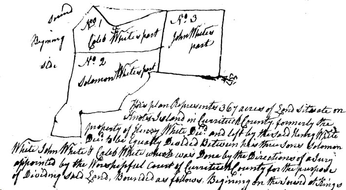
[Deed Book 7, pg. 129-130] August 28, 1794 - Sheriff of Currituck County commanded to summons William MAUND, David TATEM, Josiah NICHOLSON, Jesse SIMMONS & James PHILLIPS with the County Survayer & divide the land now possessed by Vinson WHITE in Right of his deceased Wife Elizabeth WHITE who was Elizabeth WILLIAMS agreeable to the Last Will & Testament of her deceased Father between Jacob WILLIAMS, a Son by her first Husband, and Luke WHITE, a Son by Vinson WHITE.
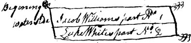
The above plat represents 108 acres on Knots Island. Jacob WILLIAMS pay unto Luke WHITE the sum of Ł40; Ł20 to be paid by Sept. 18, 1795, the other Ł20 to be paid by Sept. 18, 1796. Witness Thos. POYNER, Surveyor; Registered Feb. 7, 1794
[Deed Book 7, pg. 130] Oct. 9, 1716 - I John Lord Carterate do hereby give & grant unto John JONES SEN. 630 acres of land between Colo. William REEDs & Mr. Thomas WILLIAMs land various courses to the first. Yielding & paying yearly rent of 1 Shilling for every 50 acres. /s/ Charles EDEN; Registered Feb. 11, 1795
[Deed Book 7, pg. 130-131] Jan. 7, 1795 - No. 150 - We for the consideration of 30 Shillings for every 100 acres hereby granted paid into our Treasury by William ETHERIDGE for a tract of land containing 33 1/3 acres lying near Court House Shore. Beginning at PRESCOTTs corner along his patent to the first. Yielding and paying such sums as our General Assembly may direct, provided that William ETHERIDGE shall cause this Grant to be Registered in the Registers Office within the time limited by law. /s/ Richard Dobbs SPAIGHT; Registered March 4, 1795
[Deed Book 7, pg. 131-132] Feb. 5, 1795 - We Phillip DAUGE & Nansey his Wife, Jacob PERKINS & Peter DAUGE are held and firmly bound unto Silas BRIGHT in the sum of Ł1500. The condition of this obligation is such that Phillip DAUGE & Nansey his Wife shall at any time requested by Silas BRIGHT an absolute Right & Title to a tract of land containing 114 acres, being part of a patent granted to Rich. BRIGHT dec. dated Feb. 21, 1696, on the West side of Moyock Creek. Witness Willis ETHERIDGE, Elizabeth SAWYER; Registered March 18, 1795
[Deed Book 7, pg. 132] Feb. 7, 1795 - I Josiah HOLSTEAD for the consideration of Ł133 paid to me by Obediah CAPTS for a tract of land near Currituck Shore. Beginning at John HOLSTEADs corner with his line a straight course to a gum that divides David MATTHIAS, John, Josiah, & Reuben HOLSTEAD with Reuben HOLSTEADs line to James BRAYs line with his line to Thos. FLETCHERs orphans line with this line to the first containing 38 3/4 acres. Witness Jesse SIMMONS, John CHITTUM; Registered March 18, 1795
[Deed Book 7, pg. 133] August 23, 1794 - Henry HAMON of Tyrrel County sold to A.D. GRAVES [GREVES in other places] of Currituck County, for Ł30 Spanish Milled Dollars, a parcel of land lying in Currituck County on the North Banks, it being part of a survey taken by the said HAMON, beginning at Panters Creek and running to the head of Powls Creek, then to Buck Ridge joining the edge of a swamp then across Cowpen Ridge to Nothans Gut then to Kitihawk Bay, containing 375 acres. /s/ Henry HAMON. Wit: Henry SIKES. Registered: March 18, 1795
[Deed Book 7, pg. 134] Feb. 20. 1795 - I Mitchell DAUGE for the consideration of the Natural Love and Affection which I bear unto my Beloved Children Tamer DAUGE, Tulley DAUGE, Phebe DAUGE & Mary DAUGE & other causes hereunto me moving have given and granted after my Decease unto Tamer DAUGE 1 negro garl named Lemon, to Tulley DAUGE 1 negro boy named Daniel, to Phebe DAUGE 1 negro garl named Rachel & to Mary DAUGE 1 negro garl named Lucy. Witness: Sol. ALCOCK, S. ETHERIDGE; Registered March 18, 1795
[Deed Book 7, pg. 134-135] Dec. 20, 1794 - I Cornelius BEASLEY & Sarah my Wife of Knots Island for the consideration of Ł18 paid to us by Henry BEASLEY for a messuage of land being on Knots Island beginning at Michal WATERFIELD Jun. fence various courses to the first containing 4 acres & 140 poles. Witness Saml. JASPER, Taylor BEESLY; Registered March 18, 1795
[Deed Book 7, pg. 135] Aug. 30, 1793 - I Henry WHITE SEN. for the consideration of 60 silver dollars paid to my Son Solomon WHITE by Samuel JASPER for a parcel of land lying on Knots Island. Beginning at the dwelling house of JASPER then to Solomon WHITEs plantation thence to the road that divides sd. Land from Caleb WHITE dec’d land various courses to the first containing 3 acres. Witness Benson ETHERIDGE, James SIKES; Registered March 19, 1795
[Deed Book 7, pg. 135-136] Feb. 11, 1795 - I Malachi DUDLEY & Anne his Wife for the consideration of Ł12 paid to me by William ROGERS for a small piece of wood land. Beginning at a line between Thos. WILLIAMS & Malachi DUDLEY to the corner where John SIMPSONs land & Jacob Williams & Vinson WHITE all joins Malachi DUDLEYs land being the West end of DUDLEYs then down Jacob WILLIAMS & Vinson WHITEs line that parts DUDLEYs land from there land various courses to the first. Witness Jacob WILLIAMS, Saml. ETHERIDGE, Thos. DUDLEY; Registered March 19, 1795
[Deed Book 7, pg. 136-137] Feb. 7, 1795 - I Thomas POYNER for the consideration of 100 silver dollars paid to me by John LEE for a parcel of land. Bounded to the West by Daniel FULFORD, North William GRIFFITH, East Emley BUNNEL, South Orphans of William LEE containing 55 acres. Witness Willis ETHERIDGE, Agness ETHERIDGE; Registered March 19, 1795
[Deed Book 7, pg. 137] April 21, 1794 - Jonathan TAYLOR sold to Benjamin TAYLOR, Ł5, land bounded by Wm. NICHOLSON's old patent and Edward TAYLOR. Witnesses: Mary (x) SIMMONS and Benjamin TAYLOR; Registered 19th day, no month listed, 1795.
[Deed Book 7, pg. 138-139] Jan. 31, 1795 - I Austin SCARBOROUGH Pilot, of Cape Hatteras for the consideration of the sum of Ł20 paid to me by Thomas BRADY Pilot, for a tract of land lying on Cape Hatteras. Various courses to Thomas FARROWs line from thence to the first to conclude 50 acres of patent land. Witness Thomas SCARBOROUGH, John FLOWER; Registered March 20, 1795
[Deed Book 7, pg. 139-140] Sept. 3, 1794 - I Joseph GRAY & Mary my Wife for the consideration of Ł65 paid to us by Samuel SALYEAR for a messuage of land known by name The Cod of the Bay, that is to say our 1/3 that was laid by jury to us containing 20 acres. Witness Arthur BUTT, John ALLEN; Registered March 20, 1795
[Deed Book 7, pg. 140] July 10, 1794 - I Gamial RIGHT for the consideration of Ł100 paid to me by Jonathan LINDSEY for a negro fellow name of Sam. Witness Daniel LINDSEY, Thos. JARVES, ; Registered March 20, 1795
[Deed Book 7, pg. 140-141] July 24, 1794 - I Joseph STOW of Hatterass Banks for the consideration of Ł5 paid to me by William STOW for a tract of land lying on containing 50 acres excepting the house where John STOW now lives & the fencing upon said land. Witness John STOW, John NEEL; Registered March 20, 1795
[Deed Book 7, pg. 141] Jan. 3, 1793 - Francis FARROW of Kinnekeet Banks in Currituck County sold to Ezekiel HOOPER, for Ł50 cash, a tract of land in Currituck County joining Thomas MIDYETT's line, the sea beach and the sound, containing 50 acres. /s/ Francis FARROW, Esther [x] FARROW. Witnesses: Thos. FARROW, John FARROW, Jacob WILLIAMS. Registered: March 21, 1795
[Deed Book 7, pg. 141-142] Jan. 29, 1795 - Joseph TAYLOR and his wife Mason (also referred to as "Mabel") sold to Benjamin TAYLOR. SEN. for 120 silver dollars, land bounded by Edward TAYLOR and John TAYLOR. Witnesses: Alex WHITEHALL and John TAYLOR. /s/ Joseph (x) TAYLOR and Mabel (x) TAYLOR; Registered March 21, 1795
[Deed Book 7, pg. 143] [no date] - William PUGH, planter of Chicknecomack Banks in Currituck County, sold to David DANIEL of Ronoak Island in Currituck County, for Ł4 specie, 50 acres of land lying on Chickneacomack Banks beginning at Sanderson PAINE's line and running agreeable to Thomas PUGH's patent. /s/ William PUGH. Witnesses: John L. BOYCE, Thos. GARRETT; Registered: March 23, 1795
[Deed Book 7, pg. 143-144] Jan. 20, 1795 - Samuel MIDYETT, JUN'R. sold to Morris BAUM, both of Currituck County, for 375 Spanish mill dollars, a tract of land on Roanoak Island adjoining the lands of Joseph MIDYETT and Lazarius LINTON, the Sound and the Bay, containing 200 acres. Witness: John E. BOYCE, Zilpah BAUM
[Deed Book 7, pg. 144] Sept. 25, 1794 - Benjamin BAUM of Currituck County "...for divers considerations & good causes but more especially for the love & good will that I have to my Father & Mother, Maurice BAUM & Judath BAUM, his wife..." a tract of land lying on Roanoak Island being the same land given to my brother Thomas BAUM by his grandfather, Morris BAUM, now deceased, and by his death, to wit, my brother Thomas BAUM, I am now become heir. Witness: John E. BOYCE
[Deed Book 7, pg. 145] Feb. 4, 1795 - Samuel MIDYETT of Currituck Co. sold to Lazarus LINTON of Currituck Co., for Ł24 cash, 20 acres of land lying on Roanoke Island joining sd. LINTON's line. Witnesses: John L. BOYCE, John MIDYETT. Registered: March 23, 1795
[Deed Book 7, pg. 145-146] Dec. 20, 1794 - I Cornelius BEESLEY & Sarah my Wife of Knots Island for the consideration of Ł12 paid to me by William BEESLEY for a piece of land situated on Knots Island containing 3 acres & 55 poles. Witness Sam. JASPER, Tayler BEESLY; Registered March 23, 1795
[Deed Book 7, pg. 146] Feb. 25, 1795 - I Jonathan LINDSEY for the consideration of Ł65 paid to me by Peter SLAUGHTER for a negro garl aged 12 named Amey. Witness Thos. SANDERSON, Daniel LINDSEY; Registered March 24, 1795
[Deed Book 7, pg. 146-147] June 5, 1794 - I Carter BENNETT for the consideration of 105 Spanish dollars paid to me by Peter BALLENTINE for a negro woman named Pegg. Witness Jos. BALLENTINE; Registered March 24, 1795
[Deed Book 7, pg. 147] Aug. 26, 1794 - I Hilary LEE for the consideration of Ł8 paid to me by Linton LEE for a piece of land between Willoughby DAUGE and Linton LEE it being a part of a patent that John ETHERIDGE sold to Daniel LEE & Daniel LEE gave to Nathan LEE in his Last Will & Testament. Witness John LEE, Stephen LEE; Registered March 24, 1795
[Deed Book 7, pg. 148] Nov. 1, 1794 - I Jeremiah SEXTON Planter, of the County of Camden, for the consideration of Ł2 paid to me by Thomas LURRY of Camden County, for a parcel of land in Currituck County. Beginning at a place where LAMBS Toll Gate stood in the edge of the swamp various courses to the first containing 1 acre. Witness John MASON, J. GRANNIS; Registered March 24, 1795
[Deed Book 7, pg. 148-149] Feb. 23, 1795 - I John SLAUGHTER for the consideration of 190 Spanish milled dollars paid to me by Isiah PARR for a negro woman named Jinney with her increase. Witness Thos. MARCHANT, Thos. FEREBEE; Registered March 24, 1795
[Deed Book 7, pg. 149] Sept. 4, 1794 - I Elisha JENKINS for the consideration of Ł75 paid to me by John LEE for a tract of land bounded at the head of Tulleys Creek. Beginning near Rich. Floreys corner up the Run to John LEEs line along his line & across the land and Mirey Branch to the first containing 60 acres. Witness John CAPTS, William MANES; Registered March 25, 1795
[Deed Book 7, pg. 149-150] 1794 - I Isles SIMMONS for the consideration of Ł100 paid to me by Thomas WILLOUGHBY for a parcel of land. Beginning in John WALMSLEY line formerly Willoughby BROOKs line down the Mill Run to WALMSLEY line up the Branch to John WHEATLEYs line with his line to Panter Branch then to swamp various courses to the first. Witness Enoch DAUGE, Griffeth DAUGE; Registered March 25, 1795
[Deed Book 7, pg. 150-151] Dec. 6, 1794 - I John SIMMONS for the consideration of Ł300 paid to me by Brickhouse BELL for a parcel of land joining the head of Poyners Creek & James POYNERS orphans. Various courses to mouth of Beaver Dam Creek then to include the main body of Cyprees timber to James PHILLIPS line then to orphans line then to first to include 250 acres. Witness Jesse SIMMONS, Joseph FEREBEE; Registered March 25, 1795
[Deed Book 7, pg. 151] Oct. 27, 1794 - Nathan THOMPSON to Daniel DUNTON - Between Mason THOMPSON, Nathan THOMPSON and Penelope, his wife, for Ł150. Mentions John and Mason THOMPSON and Nathan THOMPSON and Penelope THOMPSON his wife. 80 acres if Land lying at the head of Coinjock Bay. /s/ Mason (x - her mark) THOMSON, Nathan THOMPSON, and Penelope (x - her mark) THOMPSON. Witnesses: James WHITE, William WHITE, and Nathan THOMPSON; Registered March 25, 1795
[Deed Book 7, pg. 151] Feb. 20, 1795 - I Mitchell DAUGE for the Natural Love and affection which I bear to my Son in Law Christopher WILLIAMS & other causes hereunto me moving have given and granted unto him a negro wench named Rose. Witness Sol. ALCOCK, S. ETHERIDGE; Registered March 25, 1795
[Deed Book 7, pg. 152-153] Feb. 7, 1795 - I John MORIS & Elizabeth my Wife for the consideration of Ł12 paid to me by Samuel SALYEAR for a parcel of land the 1/3 part of Rich’d BARRETs property which is Elizabeth MORISES part and dowery. Witness Saley WILLIAMS, Lydia MORIS; Registered March 26, 1795
[Deed Book 7, pg. 153] Dec. 15, 1794 - I John LEE for the consideration of Ł100 paid to me by Linton LEE for a tract of land at the head of Tulleys Creek. Beginning at the fork of the Run near Rich’d FLORIES corner up the run to LEEs line along his line across the land & Miery Branch to the first containing 61 acres. Witness John CAPTS, Frankey CAPTS; Registered March 26, 1795
[Deed Book 7, pg. 154] Jan. 21, 1795 - I Charles BRIGHT for the consideration of $10 paid to me by Demsey DOUGLES of Camden County for a tract of land in Moyock District being part of the new survey of Charles BRIGHT. Beginning at Edw. WOLDRIDGE line from thence agreeable to patent to Saml. ETHERIDGE line thence to the first containing 20 acres. Witness Demsey CASSEY, Lewis COX, Hez. PURRINTON; Registered March 27, 1795
[Deed Book 7, pg. 154-155] Jan. 20, 1795 - I Charles BRIGHT with the consent of my Wife Mary for the consideration of Ł325 paid to us by Demsey DOUGLES of Camden County for a parcel in Moyock district containing 125 acres. Joining Phillip DAUGEs line to Joseph BALLENTINEs corner various courses to Silas BRIGHTs line along his line to the first. Witness Tatem WILSON, Max. BOWREN, Demsey CASSEY; Registered March 27, 1795
[Deed Book 7, pg. 155-156] Feb. 20, 1795 - I Mitchell DAUGE for the consideration of the Natural Love & affection which I bear unto my Son Tulley DAUGE & for the better maintenance of him have granted & given unto him a certain parcel of land. Beginning at the out side rse of apple trees on the North side of the orchard running due West to Phillip DAUGEs land with his land to Samuel WHITEHURST land with his land to my back line to the first. Witness Solo. ALCOCK, S. ETHERIDGE; Registered March 27, 1795
[Deed Book 7, pg. 156] Feb. 24, 1795 - Jonathan LINDSAY sold to Gamiel WRIGHT a Negro boy by the name of Bob, for Ł100. Witness: Nathan THOMSON, John MANN(?); Registered, Mary 27, 1795
[Deed Book 7, pg. 157] Jan. 27, 1795 - I Francis WILLIAMSON for the consideration of the yearly rent of Ł30 to be paid by William WILSON of Virginia for a farm let on my plantation & farm whereon Willoughby Brooks deceased formerly lived during the term of 4 years from dater hereof. Besides the above rent to put a new shed to the dwelling house 10 ft. wide & to clair a point of thicket next to main road, & also to repair the barn & to return the fencing in as good order as he received them. Witness Jona. WILLIAMSON, Simon WILSON; Registered March 27, 1795
[Deed Book 7, pg. 157-158] Jan. 14, 1795 - I Thomas JARVES for the consideration of Ł200 paid to me by James W. COATS of Camden County for a parcel of land. Beginning at the head of Ales Creek binding on Gameal WRIGHTs line to Wm. RUSSELs line along his line to John LINDSEYs line with his line to water hole then to the Sound so as to make 200 acres along Sound to first. Witness Malachi COATS, Thos. JARVES; Registered March 28, 1795
[Deed Book 7, pg. 158] Feb. 27, 1795 - John WILLIAMS sold to William and Sally TAYLOR, all of Currituck Co., for Ł50, 50 acres of land in Currituck bounded by John WILLIAMS, William ETHERIDGE, and Isaac YOUNGHUSBAND. Witness: Jas. PHILLIPS, John WOLMSLEY(?); Registered March 28, 1795
[Deed Book 7, pg. 159-160] Feb. 23, 1795 - I Moses BENNETT for the consideration of Ł40 paid to me by John BENNETT for a persel of land. Binding on Joseph BALLENTINE land various courses to the first containing 13 acres. Witness Joseph BALLENTINE, Peter BALLENTINE; Registered March 31, 1795
[Deed Book 7, pg. 160] Feb. 23, 1795 - I Mary BALLENTINE for the consideration of the Natural Love & affection I bear unto Juley BALLENTINE & also me thereunto moving have given & granted unto her a negro girl named Affe & her increase but for me to have the use of the negro during my life. I also give 1 bed & furniture, 1 cow and calf, 6 winzer chairs, 1 linnen weal to her & her heirs but if she dies first then the above gift to return to me. Witness Joseph BALLENTINE; Registered March 31, 1795
[Deed Book 7, pg. 160-161] Dec. 12, 1794 - I Solomon COX for the consideration of $150 paid to me by Joseph BALLENTINE for a parcel of land about 2 miles from Moyock Mill a place called Light Swamp. Beginning at Maxinmilion BOWRENs corner various courses to a line called BURNHAMs line various courses to the first containing 100 ˝ acres. Witness Solo. ALCOCK, William ETHERIDGE; Registered March 31, 1795
[Deed Book 7, pg. 161-162] Jan. 28, 1795 - I John HUMPHRIES for the consideration of $300 paid to me by Isaiah PARR for a tract of Swamp land being the tract patented by Jeremiah MERCER. Beginning near the Indan line thence to East Crick up & across the crick to William FEREBEEs line containing 301 acres. Witness William BRUMSEY, Lydia HUMPHRIES; Registered April 1, 1795
[Deed Book 7, pg. 162] Feb. 20, 1795 - I Josiah NICHOLSON & Rebekah for the consideration of Ł10 paid to me by Edward LEECH for a parcel of land at large will appear by patent date Nov. 15, 1790 containing 75 acres. Beginning at the corner of HILFORDs house then to Thos. PARKERs line along his line to Francis BROWNs line along his line binding on swamp near whare Abel ROBERTS lived various courses to Evan MILLER line along his line to first. Witness Michal MACKINTIER, Henry SIKES; Registered April 1, 1795
[Deed Book 7, pg. 163] Nov. 12, 1793 - Benjamin TAYLOR, JUNIOR sold to Benjamin TAYLOR, SENIOR, for Ł6, land near Edward TAYLOR's gap; also bounded by John TAYLOR, JUNIOR and Joseph TAYLOR. Witnesses: Hosea BALL and Polly (x) SIMMONS; Registered first day of 1795
[Deed Book 7, pg. 164] Dec. 16, 1794 - Benjamin TAYLOR sold to Griffin GRAY for $175, 50 acres of land bounded by John TAYLOR & Jonathan TAYLOR. Witnesses, Hosea BALL, Lemuel SANDERSON. Registered first day of 1795
[Deed Book 7, pg. 165] July 22, 1794 - I William FREEMAN & Ann my Wife for the consideration of Ł22 paid to me by Thomas FEREBEE for a tract of land situate on Moyock Creek near Moyock Mill. Beginning various courses to oposite the publick landing thence to Robt. FEREBEEs line along the cutway to the first containing 8 acres. Witness Jona. WILLIAMSON, Martha WILLIAMSON, Edw. CHRISTOPHER; Registered April 1, 1795
[Deed Book 7, pg. 165-166] July 10, 1794 - I Joseph GRAY for the consideration of $180 hard dollars paid to me by Capt. Isaiah PARR for a negro wench by name of Gin. Witness Solo. ALCOCK, William BRUMSEY; Registered April 2, 1795
[Deed Book 7, pg. 166] Feb. 18, 1792 - I Matthias WILLIAMSON do appoint my trusty friend Joseph BALLENTINE my lawfull Attorney for me & in my name to receive money due me or to sell in my behalf. Witness William FREEMAN; Registered April 2, 1795
[Deed Book 7, pg. 167] April 17, 1793 - I Abraham BAUM & Maurice BAUM for the consideration of Ł30 has bargain granted & sold to Abel ASHBEE The priviledge of the pasturage for the term of 30 years, 2 horses, his calfs, & yearling or a cow for the winters eull or mare in covering time or time of having her colt. /s/ Morris BAUM, Abraham BAUM, Azariah BAUM. Witness Absolom DOLBE, Abraham BAUM, Reuben ETHERIDGE William PRICE; Registered April 20, 1795
[Deed Book 7, pg. 167] May 5, 1795 - The Private Examination of Elisabeth PELL taken May 5, 1795: that she did on Aug. 20, 1794 by her own free will and accord sign a Deed of Sale to Nathan HALL. Acknowledged in Camden County. William NEAVILL, J.P.; Registered July3, 1795
[Deed Book 7, pg. 167-168] Aug. 25, 1793 - I William LUM for the consideration of Ł30 paid to me by George POPERWELL for a tract of land on the North Banks. Beginning at Lumars Bay running with John BEACHAMs line to the Fresh Pon Runn thence to the Sea Side various courses to Thos. TILLOTs line to Lomars Bay then to first containing 100 acres. Witness Nathan Hall, Lindsey Chandler; Registered July 3 1795
[Deed Book 7, pg. 168] Sept. 26, 1794 - I Willis GUIN for the consideration of Ł11 4 shillings paid to me by John GUIN for a piece of land containing 4 acres. Beginning down Jacob LITCHFIELDs line thence to Ann SMITHs line thence to the first on Jacob LITCHFIELDs line. Witness Solomon WHITE, Willis WICKER; Registered July 3, 1795
[Deed Book 7, pg. 169] August 11, 1794 - Thomas AUSTIN of Hatteras Banks sold to William AUSTIN of Hatteras Banks, for Ł10 currency of NC, a tract of land on Hatteras Banks containing 50 acres and joining Daniel AUSTIN's line and the sound. Witnesses: John BALLANCE; Thomas BALLANCE. Registered: July 3, 1795
[Deed Book 7, pg. 169-170] 1795 - I Thomas BEST for the consideration of Ł15 paid to me by William ETHERIDGE for a parcel of land on the North Banks called Kittehawk. Beginning at a swamp to Kittehawk Ridge running along Shadrick GALLOPs line thence to the Great Wading place then running up to the first containing 50 acres. Witness William BEST, James ETHERIDGE; Registered July 3, 1795
[Deed Book 7, pg. 171] May 16, 1795 - I Jesse JENNETT of Cape Hatteras Banks for the consideration of Ł37 10 Shillings cash, paid to me by William BALLANCE for a tract of land on Cape Hatteras . Between Jesse JENETT & Joseph JENETT deceased then to the Sea Side then to the first containing 75 acres of patent land. Witness John FLOWER, John BALLANCE ; Registered July 4, 1795
[Deed Book 7, pg. 172] Nov. 7, 1793 - I William DUNSTON for the consideration of Ł12 paid to me by Thomas BEST for a tract of land lying on the North Banks in my patent. Beginning on Dansing Ridge various courses to the first. Witness Benj. GAMEWELL, Lamuel TILLETT, Wm. BEST; Registered July 4, 1795
[Deed Book 7, pg. 172-173] No date - I Mary Ann BEECHUM for the consideration of Ł10 paid to me by William BEST for a parcel of land on the North Banks at the head of Kitty Hawk Bay containing 40 acres. Witness Lemuel TILLOTT, Thos. BEST; Registered July 7, 1795
[Deed Book 7, pg. 173-174] Feb. 9, 1795 - I William DANIEL for the consideration of Ł10 paid to me by John WESKETT for a parcel of marsh lying on Ronoak Island adjoining the head of Broad Creek. Beginning at the head of the Creek adjoining Solomon ASHBEEs line to Mr. JOHNSTONs line thence adjoining Mr. JOHNSTONs line to ETHERIDGEs line then adjoining ETHERIDGE line to Mauris BAUMs line the BAUMs to the first containing 100 acres. Witness Charles WILLIAMS, Morris BAUM; Registered July 7, 1795
[Deed Book 7, pg. 174] Oct. 21, 1794 - I William WILLIAMS of Ocrecock for the consideration of Ł40 paid to me by Jesse JENNETT of Cape Hatteras Banks for a parcel of land on Cape Hatteras Banks. Beginning at the Sound running with James WAHAB line to the back line with the back line to conclude 50 acres. Witness William BALLANCE, William MILLER, John BALLANCE ; Registered July 7, 1795
[Deed Book 7, pg. 175] March 27, 1795 - I John SIMSON hereby lease unto my Brother Malachi SIMSON my plantation that joins the publick road on which Malachi SIMPSON now lives. I let him have it during his life reserving to my self ˝ the fruit in the orchard on plantation for the term of 4 years. Nether shall my Brother Malachi SIMSON settle any person whatever to live on said plantation nor sell any timber, fire wood, not light wood which if he dose this lease is void. Witness William ROGERS, Malachi DUDLEY; Registered July 7, 1795
[Deed Book 7, pg. 175] 1795 - Nathan THOMPSON to Samuel SALYEAR. In a deed for slaves brought before the Currituck Court in the May 1795 term and registered, July 7, 1795, Nathan THOMPSON and his wife Penelope accepted Ł25 for Penelope's share of slaves given her by her grandfather, Hugh McCOY, late of Norfolk County, Virginia according to his will. These slaves were to accrue to her after "her father Reuben TAYLOR's death".
[Deed Book 7, pg. 176-177] May 9, 1795 - We Nathan & Spence HALL for the consideration of Ł15 paid to us by John DOUGH for a parcel of land situate on Currituck Banks. Beginning at ROBERTSONs Creek at DOUGHs corner along Creek through the marsh various courses to Spence Halls new patent line along the patent line to DOUGHs old patent line to the first containing 60 acres. Likewise ˝ of a piece of land & marsh lying to the Westward of ROBERTSON Creek & binding Isaac TILLETTs land & Currituck Sound containing 30 acres. Likewise ˝ marsh I own to the Soutward of Panters Creek. Witness Saml. JASPER; Registered July 7, 1795
[Deed Book 7, pg. 177-178] May 18, 1795 - I Francis FARROW of Cape Hatteras Banks for the consideration of Ł30 cash paid to me by Thomas FARROW for a tract of land near the Cape. Beginning in the marsh which was bounds between Thomas FARROW line to the Sea beach then along the top of the banks to conclude 50 acres, running to the line of Thomas FARROW new patent then along the line of FARROW new patent to the first to conclude 50 acres. Witness Hezekiah FARROW, John FARROW ; Registered July 8, 1795
[Deed Book 7, pg. 178] April 18, 1795 - I John ACKISS for the consideration of Ł7 & 10 Shillings paid to me by Peter MALBONE for a parcel of marsh land containing 50 acres lying in the Great Marsh adjoining the marsh formerly Tully SMITH & George JAMISON Pasture. Witness James GARNTO, John STONE; Registered July 18, 1795
[Deed Book 7, pg. 178-179] March 25, 1795 - I Samuel SALYEAR Sheriff by virtue of Writ of Faire Facis issued out of the Court of Please & Quarter Session commanding me out of the goods chattles & lands of James LEE cause to be made the sum of Ł159 11 Shillings 9 Pence which John WALMSLEY has been adjudged against LEE. In obedience to Writ I did enter and take into possession a tract of land beginning on the Bay side at John BRYANTs corner thence to Francis WILLIAMSONs corner with his line to BARNARDs corner along his line to Moses CAPTS line along his line to the Bay thence to the first containing 25 acres. By public sale on March 25, 1795 where & when John BRYANT did appear & bid Ł62 10 Shillings & was highest bidder. By virtue of Writ I have granted & conveyed unto John BRYANT the said parcel of land. Witness Jesse SIMMONS, William BRABEL; Registered July 8, 1795
[Deed Book 7, pg. 180] May 14, 1795 - I Mitchal DAUGE for the consideration of Ł84 paid to me by Phillip DAUGE for piece of land. Beginning where 2 ditches meets near the plantation whereon I now live various courses to ETHERIDGES corner thence to Thos. STANLEY corner along his line various courses to the first containing 26 acres 1 Rod & 22 Poles, it being part of the tract whereon I now live. Witness Willis SAWYER, Elizabeth SAWYER; Registered July 9, 1795
[Deed Book 7, pg. 181] May 9, 1795 - I Charles WARD for the consideration of 75 Spanish milled dollars paid to me by Jesse SIMMONS for a piece of land lying on Currituck Shore. Beginning at the mouth of a large ditch on the Shore side David TATOMs corner various courses to the first containing 24 5/8 acres. Witness Godfray WHITHOUS, Edny SIMMONS ; Registered July 9, 1795
[Deed Book 7, pg. 181-182] Oct. 8, 1794 - I Elisha JANKINS for the consideration of the yearly rents have let unto William MAINS all that farm or plantation whereon he now lives for the term of 8 years. Paying as follows to clear all the cutdown deaded ground inclosing the same under good fence, triming & keeping the orchard in good repair the hole plantation to be returned in good repair. Witness John CAPTS, Charles McCARTER. Feb. 2, 1795 - I William MAINS have given up all my right of the premises within mentioned to Willis SIMMONS; Registered July 9, 1795
[Deed Book 7, pg. 182-183] May 25, 1795 - I Benjamin COX for the consideration of 20 Silver Dollars paid to me by Edward LEECH for a messuage of land near Cowinjock Chappel containing 4 acres. Witness Isaiah PARR; Registered July 9, 1795
[Deed Book 7, pg. 183] July 29, 1784 - I Joseph TOCKSEY received of Spence HALL Ł10 being full payment for a piece of land lying on Powels Point formerly claimed by John NORTON binding Asa ETHERIDGE. Witness Spence HALL ; Registered July 9, 1795
[Deed Book 7, pg. 183-184] April 15, 1795 - I John BARRETT for the consideration of Ł4 paid to me by Elijah ADDERSON for a tract of land situated between Currituck Inlet & Providance Inlet which land is called Bank Land. Binding on land of WATERFIELDs to the Sea Side binding with Sea Side containing 50 acres. Witness Randolph JONES, Mary JONES; Registered July 10, 1795
[Deed Book 7, pg. 184-185] May 4, 1795 - I Thomas PARKER & Elizabeth my Wife for the consideration of $409.50 paid to me by Benjamin COX for a tract of land near Cowinjock Chappel. Various courses to Colo. Josiah NICHOLSONs line to the first containing 91 acres. Witness George HOWARD, Willis ETHERIDGE, Isles SIMMONS; Registered July 10, 1795
[Deed Book 7, pg. 185-186] May 4, 1795 - I Benjamin COX am held & firmly bound unto Thomas PARKER in the just sum of Ł250. The condition of the obligation is such that Benjamin COX shall provide for Thomas PARKER ˝ of all his support during his natural life as followed: sufficient house room & fire side & ˝ of the meat & drink washing & lodging & ˝ the cloth for winter & summer & all other nessarys of life both in sickness & helth. Witness George HOWARD, Willis ETHERIDGE; Registered July 11, 1795
[Deed Book 7, pg. 186-187] May 19, 1795 - I Phillip DAUGE for the consideration of Ł60 paid to me by Nathaniel HUTCHINS for a parcel of land. Beginning in Jesse GREGORYs line to the corner of Rich’d HUTCHINS line & Tulley DAUGE down DAUGEs line to Thos. HUTCHINS new patent then with PERKINS old patent line to the first containing 100 acres. It being part of the land that James DAUGE will to Phillip DAUGE. Witness Francis DIVERS, Charity DIVERS; Registered July 11, 1795
[Deed Book 7, pg. 187-188] May 26, 1795 - I Caleb WILSON for the consideration of 36 Silver dollars paid to me by Willoughby WEST for a parcel of land beginning on Moyock Creek joining Matthew BENNETs land binding on Bennetts land to Joseph BALLENTINEs thence along his line to Moses BENNETs land thence binding his land to Moyock Creek along the Creek to the first containing 31 ˝ acres. Witness Joseph BALLENTINE; Registered July 11, 1795
[Deed Book 7, pg. 188] May 28, 1794 - I Luke BERNARD, Planter, am held & firmly bound unto Thomas COX, Planter, in the just sum Ł50. The condition of the obligation is such that Luke BARNARD shall and truly make a good lawful title by Deed to 4 acres of land that adjoins Thomas COXs land 2 acres of which is already laid off the other 2 acres to be laid off adjoining afore mentioned 2 acres which makes 4 acres within 3 years from date hereof. Witness David MILBZ(MINTZ?), Edw. DOUGHTY; Registered July 13, 1795
[Deed Book 7, pg. 189] February 23, 1795 - Marmaduke COX, planter of Currituck County sold to James GARROT of Currituck County, for Ł20 current money, a tract of land in Currituck Co. beginning at Thomas COX's line and joining Marmaduke COX, containing 23 acres. Witnesses: David MILLBY?, Thos. COX, John [x] ALLISON. Registered: July 13, 1795
[Deed Book 7, pg. 189-190] May 23, 1795 - Samuel MIDYETT of Currituck County sold to Lazarus LINTON of Currituck Co., for Ł55 current money, a tract of land lying on Roanoke Island joining Samp. DAUG line & Joseph MIDYETT's corner and the Sound, containing 50 acres. /s/ Samuel [x] MIDYETT, Ann [x] MIDYETT. Witnesses: G. CLARK, Darius [x her mark] DOWDY. Registered: July 13, 1795
[Deed Book 7, pg. 190-191] Aug. 22, 1795 - I Thomas BEST Planter, do nominate and appoint my friend Samuel SALYEAR Esq. to be my lawful Attorney, to ask & receive of William SANDERS of Caswell County all & every sum of money that he may have in his hands belonging to me. Or that he may have drawn of mine from Board of Commissioners for setling any accounts money or certificates that lawfully aught to be mine for serving as a Continental Soldier in the late War. Witness S. HALL, Wm. TOLER; Registered Sept. 2, 1795
[Deed Book 7, pg. 191] April 20, 1682 - I Henry CHICKLEY Depty. Governor give & grant unto George BULLOCK 300 acres of land & marsh called Bullocks Ridges situated on the Northward part of Knots Island in Currituck in the County of Lower Norfolk. Various courses to a Creek & marshes dividing this land and the land of John LEGATT and Richard WICKER then to the first, being due for 6 persons. Registered Sept. 1795
[Deed Book 7, pg. 191-192] Mar. 2, 1740 - Know ye that we for and in consideration of the rents and duties herein reserved have given and granted unto George SMITH a tract of land containing 1200 acres. Beginning at a white oak joining Cornelius JONES run various courses to Wm. WHITE then various courses to the first. Yielding & paying unto us the yearly rent of 4 Shillings for every 100 acres, provided George SMITH shall within 3 years after date hereof clear & cultivate 3 acres for every 100, also this letter of Patent shall be entered in the office of Auditor General within 6 months after date hereof. /s/ Gabrel JOHNSTON; Registered Sept. 4, 1795
[Deed Book 7, pg. 192-193] No date - To William NEAVIL Esq. whereas Nathan HALL provided a Deed of Conveyance made to him by Joseph PELL & Elizabeth his Wife and she cannot travel to our Court to be privately examined as to her consent to execution of said conveyance you are to privately examine Elizabeth PELL. This commission is Registered Sept. 4, 1795
[Deed Book 7, pg. 193-194] Apr. 21, 1793 - I William BEST for the consideration of Ł30 paid to me by Benjamin GAMEWELL for a tract of land on the North Banks. Beginning at the Duck Pond at Wm. SIMSONs line running up the pond various courses to the first containing 50 acres, being in William DUNSTONs Patent. Registered Sept. 24, 1795
[Deed Book 7, pg. 194] Feb. 11, 1794 - Samuel SALYEAR, JR., Esq. and Sarah his wife sold to Alex. S. WHITEHALL, Esq. for Ł400, 100 acres of land in Currituck beginning at the water at the beginning of Foster JARVIS patten, Samuel SALYEAR (not clear whether Jr. or SEN.) /s/ Saml. SALYEAR JR. Sarah SALYEAR. Witnesses: Wm. WOODHOUSE, Jesse TAYLOR; . Registered September 24, 1795
[Deed Book 7, pg. 195] June 4, 1795 - I Mathias WILLIAMSON for the consideration of 25 Silver Dollars paid to me by Abell ETHERIDGE for a tract of land lying in the Light Swamp. Beginning at Caleb ETHERIDGE corner along his line to Daniel McPARSASHON line thence to Joseph FEREBEEs first beginning down his line to the first containing 50 acres. Witness Jos. BALLENTINE, Lovey BALLENTINE; Registered Sept. 24, 1795
[Deed Book 7, pg. 196] May 20, 1795 - I John SANDERSON for the paternal affection I bear to my Son Danil SANDERSON as well as the sum of 20 Shillings paid to me on behalf of him do give & grant unto him a negro fellow caled ????? , a negro boy named Charles and negro gairl Sairey 1 feather bed and firnator and large dish and ??? head of cattle and 1/3 part of my sheep and hogs. Witness Daniel LINDSEY, Joseph EAVERTON; Registered Sept. 25, 1795
[Deed Book 7, pg. 196-197] Sept. 1794 - I James PARKER for the consideration of Ł10 paid to me by Mathias TOLER for a parcel of land on the North Banks containing 100 acres. Beginning at DUNSTONs line on Currituck Sound thence to the Sea various courses to the first. Witness John BARCLIFT, Clement HILL, Mathias TOLAR ; Registered Sept. 25, 1795
[Deed Book 7, pg. 197] Aug. 25, 1795 - Mary THOMPSON to her son Malachi THOMPSON, both of Currituck County. Deed of gift. /s/ Mary (x) THOMSON. Witnesses: Josiah NICHOLSON, William THOMSON. On September 23, 1795, registered on oath of Josiah NICHOLSON. 17 1/2 acres. Division between me (Mary) and son John THOMPSON. Bordered by William ROBERTSON and Willis WALKER. Land by great swamp bridge.
[Deed Book 7, pg. 198] May 26, 1795 - I William POYNER for the consideration of Ł8, 1 Shilling & 6 Pence paid to me by Burrus MATTHIAS for a piece of land. Beginning at a corner John WILLIAMs new entry straight course to William ETHERIDGE line along his line to Jesse HOLSTEADs line along his line to MATHIAS old line along his line to the first containing 8 ˝ acres. Witness Ked. MULDAR, Zach. MORSE; Registered Sept. 28, 1795
[Deed Book 7, pg. 198-199] May 25, 1795 - I John SANDERSON for the paternall affection that I have and bear to my Daughter Susannah SANDERSON & my Son John SANDERSON as well as the sum of 40 Shillings paid in behalf of my children, I do give & grant unto Susannah a negro fellow named Toney & a negro gairl named Non & 1 Green chest & 1 sider lum & harness & 4 head of cattle1 feather bed & furniture & I give unto my Son John SANDERSON a negro fellow named Jones & 1 negro wench named Pagey & her 2 children Denise & Rachel 1 feather bed & furniture 1 young large bay mare 4 head of cattle & 4 ews & lambs. Witness Daniel LINDSEY, Joseph EVERTON; Registered Sept. 28, 1795
[Deed Book 7, pg. 199-200] Nov. 22, 1793 - I John HUMPHRIES Esq. & Mary my Wife for the consideration of Ł269 paid to me by Samuel SALYEAR Esq. for a parcel of land. Beginning on the water Samuel SALYEAR corner then to JARVES patent course of patent to SALYEARs other corner various courses to the first containing 50 acres. Witness MalachI JONES, And. DUKE; Registered Sept. 29, 1795
[Deed Book 7, pg. 200-201] June 29, 1795 - I Thomas BEST for the consideration of Ł10 12 Shillings & 6 Pence paid to me by Thomas JONES for a parcel of land on North Banks. Beginning at Wm. DUNTONs line by the side of Hill Point Gut with his line to the High Bridge various courses to the first containing 40 acres. Witness Peter BRICKHOUSE, Leven TWYFORD; Registered Sept. 29, 1795
[Deed Book 7, pg. 201-202] June 2, 1795 - I Euphan STANLEY for the consideration of Ł42 15 Shillings paid to me by James BALLENTINE for a piece of land in Moyock containing 25 acres on the North side of Moyock Creek. Beginning near Moses BENNETs line along his line to Moyock Creek up a branch called Swanns Cove between Euphan STANLEY & Thos. FEREBEE then to the first. Witness Jonathan WILLIAMSON, Matthias WILLIAMSON; Registered Sept. 29, 1795
[Deed Book 7, pg. 202-203] June 23, 1795 - I Matthew BENNETT for the consideration of 80 Silver dollars paid to me by Willoughby WEST for a tract of land about 1 mile from Moyock Mill joining the North side of Moyock Creek & the land belonging to James BALLENTINE, then binding Nancey STANDLEY land then binding on Joseph BALLENTINE land then the land formerly belonging to Caleb WILSON containing 13 ˝ acres. Witness Jos. BALLENTINE, John BENNETT; Registered Sept. 29, 1795
[Deed Book 7, pg. 203-204] Aug, 29, 1795 - I Edward PARKER & Sarah my Wife hath Leased unto John CONWAY our 1/3 of the Norward plantation which was given by George Day WEST to his 2 Daughters Lurena WEST & Nancy WEST during my Wifes Natural life. John CONWAY doth agree to pay 3 barrels of corn per year. Witness John MACORY, Elizabeth NEEDAM; Registered Sept. 29, 1795
[Deed Book 7, pg. 204] June 3, 1795 - I Spence HALL for the consideration of 35 Silver Dollars paid to me by John MINCHEY for a piece of land on the Currituck Banks. Beginning at Jane Guyte Creek then to the Sea Side then along the Sand Hills to HERBERTs land binding on his land to Jane Guyte Creek various courses to the first agreeable to a deed HALL had of Matthias TOLER containing 180 acres. Witness William LUNN, Jesse DUKES; Registered Sept. 30, 1795
[Deed Book 7, pg. 204-205] Sept. 5, 1794 - I William FOUNTIN for the consideration of Ł28 paid to me by Joseph CHAPMAN & Benjamin HASSELL for a messuage of land on the North Banks. Beginning at the Sea and running across the Fresh Pond then to the 2/3 of the land patened by John ARES which contains 200. Witness Thos. JARVES, Sarah SANDERSON; Registered Sept. 30, 1795
[Deed Book 7, pg. 205] Dec. 12, 1794 - I Thomas JARVES & Lydia my Wife for the consideration of Ł225 paid to me by Lemuel GREGORY for a parcel of land 420 acres of land marsh & swamp on the North side of the Redy Branch. Will more fully appear by patent & Deeds from the Rev. James GAMEWELL. Witness Lemuel SIMMONS, Thos. SAWYER; Registered Sept. 30, 1795
[Deed Book 7, pg. 205-206] Jan. 12, 1794 - I Lemuel SIMMONS & Fanny his Wife for the consideration of Ł62 10 Shillings paid to me by Thomas JARVES for a parcel of land containing 300 acres of land marsh & swamp situated on Currituck Sound. Beginning at the mouth of Webs Creek then to the head of JARVES line then to whereon Peter GORDEN now lives thence binding Joseph Evans & Spence WALKERs line binding Thomas WALKERs line down to Currituck Sound along the Sound various courses to the first. Witness Wm. CHANDLER, Wm. LINDSEY; Registered Sept. 30, 1795
[Deed Book 7, pg. 206] Aug. 12, 1795 - I Sarah GORDEN for the love good will and affection I bear towards my loving child Elizabeth GORDEN hath given granted unto her all & singular my goods & chattles, 1 cow & 1 star (steer) 1 linen wheel 2 stock of bees, 1 loom of which before the signing of these presents I have delivered her. Witness Gamiel WRIGHT; Registered Sept. 30, 1795
[Deed Book 7, pg. 207] Aug. 31, 1795 - I Willoughby WHITE am held and firmly bound unto Daniel DUNTON in the sum of Ł500. The condition of the obligation is that Willoughby WHITE will never debar or hender Daniel DUNTON from keeping 10 head of stock as cattle, horses, mares, or sheep as long as number does not exceed 10 head on Crow Island. Witness Josiah NICHOLSON, William BRABBELL; Registered Sept. 30, 1795
[Deed Book 7, pg. 207-208] Aug. 31, 1795 - I Daniel DUNTON & Director my Wife for the consideration of Ł300 paid to me by Willoughby WHITE for a tract of land known as Crow Island lying near Currituck Inlet containing 120 acres, being the same land Waterfield DUNTON bought of John ACKISS, & ACKISS bought of Butler COWELL & John SIMMONS. Witness Josiah NICHOLSON, William BRABBEL; Registered Oct. 1, 1795
[Deed Book 7, pg. 208] June 1, 1795 - I Spence HALL for the consideration of $5 to me paid and I have sold my right title unto Joseph GORDEN Son of Peter one crumpled horned cow & yearling and calf that belongs to the cow. Likewise for the sum of $5 I sell my right to Jeremiah GORDEN to 1 cow with a white back & the yearling belonging to her. Likewise for $5 I sell to Polly GORDEN my right of 1 brinded cow to her forever. Likewise I sell to James GORDEN my right of 1 red cow calf & yearling to him forever. I purchased the cattle at publick vendue taken by execution. Witness Polly GREEN; Registered Oct. 1, 1795
[Deed Book 7, pg. 209] Feb. 6, 1795 - I Thomas JARVES leased or rented unto Peter GORDEN for his Natural life the plantation where John GILBERT formerly lived with liberty to clear & inlarge plantation as he pleases to the westerd of plantation between 2 souvanners [savannahs] & liberty to cut rale timber to fence the cleared land and to keep the same in good order and fire wood with no wast. GORDEN shall not sell or convey his liberty or lease to any other person whatsoever nor worry what land is or may be cleared, & he to pay yearly rent of 1/16 of a Dollar, & I Thomas JARVES do bind myself in the sum of $100 not to turn GORDEN off said land. Witness Wm. CHANDLER, Lem. SIMMONS; Registered Oct. 1, 1795
[Deed Book 7, pg. 209-210] Jan. 12, 1795 - I Charles BRIGHT for the consideration of 30 hard Dollars paid to me by DAVID MERCEREAN of New York for a tract of land. Beginning in Sam. ETHERIDGE line various courses to Henry BRIGHTs line along his line to the first containing 60 acres. Witness Sam. WALLIS, Nicholas SLACK, Hezekiah PURRINTON; Registered Oct. 2, 1795
[Deed Book 7, pg. 210-211] Aug. 11, 1795 - I Jeremiah MERCER for the consideration of Ł38 paid to me by Griffeth DAUGE for a piece of land. Beginning at the edge of East Creek where Jeremiah MERCER line comes down to Creek along the Creek to the Indian line with this line to Benters? MERCERs line along his line to the first to contain 155 acres. Witness Solomon ALCOCK; Registered Oct. 2, 1795
[Deed Book 7, pg. 211] Aug. 28, 1795 - I John ACKISS of Princess Anne County Virginia for the consideration of Ł50 paid to me by Thomas ACKISS for a track of land & marsh containing 60 acres near North River granted by patent to Elijah ANDERSON adjoining the land of Thomas WHITEs, sold by Eijah ANDERSON to Thomas YOUNGHUSBAND by him sold to John ACKISS deed dated June 7, 1785. Also another tract of land & marsh containing 340 acres known by name of Manadus Island & Ridge. Beginning at mouth of Manadus Creek running up Creek to the head then to Goos Pond Creek various courses to first adjoining North River being part of patent granted to Alex. LINDSEY by him sold to Thos. YOUNGHUSBAND by him sold to me. Witness William WICKER, William CAPPS, Antho. MURPHY; Registered Oct. 2, 1795
[Deed Book 7, pg. 212] Aug. 29, 1795 - I John ACKISS of Princess Anne County Virginia for the consideration of 40 Shillings paid to me by James BROCK for 25 acres of marsh lying in the Great Marsh surveyed by George JAMISON & myself. Witness William CAPPS, William WICKER, Antho. MURPHY; Registered Oct. 3, 1795
[Deed Book 7, pg. 212-213] Aug. 29, 1795 - I Peter MALBONE of the County of Princess Anne Virginia for the consideration of 50 shillings paid to me by Richard BONNEY for 25 acres of marsh lying between JAMESONs Point & Knots Island. Witness Wm. CAPPS, James BROCK, Wm. WICKER; Registered Oct. 3, 1795
[Deed Book 7, pg. 213] 1794 - John WILLIAMS, blacksmith, sold to Thos. MILLER, planter, for the sum of [blank], 50 acres bounded by LIINDSAY, YOUNGHUSBAND. Witness: William TAYLOR; Registered October _, 1795.
[Deed Book 7, pg. 214] Jan. 7, 1795 - Richard Dobbs SPRAIGHT to George FISHER - Patent #154, for 30 shillings per every 100 acres, land containing 100 acres in the Great Swamp near John TAYLORs patent. Registered: Oct. 5, 1795.
[Deed Book 7, pgs. 214-215] July 19, 1792 - Sam. Bunnell & Benjamin SANDDOR, JR. of Essex Co., New Jersey, are held and firmly bound to Samuel JASPER of Currituck Co., for Ł200. The condition of above obligation is such that Sam’l BUNNEL & Benjamin SANDDER shall pay within 12 months ensueing the date hereof unto said SAMUEL JASPER the just sum of $175. Witnesses: William BROADWELL, Azariah CLARK. Aug. 3, 1793 - Rec’d the sum of Ten Pounds & Eleven shillings as part of the within bond. /s/ Andrew BATES. Registered: Nov. 6th 1795.
[Deed Book 7, pg. 215] To any Regular Minister of the Gospel or Justice of the Peace of said County these are to authorize and empower you or any of you to Celebrate the Rites of Marriage Between John OLIFFE and Abigale ODEON of this County & Join them together as man & wife in Holy Wedlock; given under my hand & seal at office this 22nd day of November 1795. Wm. TAYLOR Dept. Clk Court. These may certifye to all to whome it may concern that John OLIFFE and Abigale ODEON was lawfully joined together as man and Wife in holy Matrimony the 22nd Day of November 1795. /s/ Willis ETHERIDGE, J.P. Registered the 23rd Day of November 1795 [MARRIAGE RECORD - see image]
[Deed Book 7, pg. 215] Richard Dobbs SPAIGHT to John DOXEY, SEN. - Patent #159. Ł10 per every 100 acres. One hundred acres lying in Currituck, bounded by John BALLANCE, NICHOLSON's line, James ETHERIDGE. /s/ Rich. Dobbs SPAIGHT by J. GLASGOW, Secretary. November 10, 1795.
[Deed Book 7, pg. 216] Nov. 10, 1795 - Richard Dobbs SPRAIGHT to Nathan BALL - Patent #162, for 50 Shillings for every 100 acres of Land paid into our Treasury by Nathan BALL do give and grant a tract of land containing 300 acres beginning on the East Swamp dividing line between land Reuben BALL dec’d formerly lived and land formerly Lemuel SIMMONS then North binding on the lands formerly Reuben BALL dec'd, Hosea BALL and Joshua BALL to a gum in Samuel EADY line. Registered: Jan. 8, 1796.
[Deed Book 7, pg. 217] May 11, 1795 - I Edward TAYLOR for the consideration of $41 2/3 paid to me by Joseph GRAY for 3 tracts of land formerly the property of Colo. John WOODHOUSE dec’d.
1st tract where John WOODHOUSE lived & at his decease willed to his son Lemuel WOODHOUSE. Beginning on Sound side then to Alexander WHITEHALLs line into the Flat Swamp then to Thos. TAYLORs line thence ???? & JARVIS line to the Sound side then to first containing 400 acres.
2nd on Churches Island which Colo. John WOODHOUSE willed to his son John WOODHOUSE which begins across the Island to Cowinjock Bay various courses of the water & marsh to John HUMPHRIES line thence binding with HUMPHRIES line to the Sound side binding the Sound to the first containing 400 acres.
3rd tract called Piney Island which Colo. WOODHOUSE willed equally between his 2 Sons Lemuel & John beginning at the head of Cowinjock Bay through Piney Island to the mouth of Back Creek along the Bay to the end of Long Point to the first containing 400 acres. Witness Thos. HEATH, Benj. TAYLOR; Registered Jan. 9, 1796
[Deed Book 7, pg. 218] Nov. 26, 1795 - I Joyce SHANNEN for the consideration of Ł50 paid to me by Jacob SAWYER for tract of land near the mouth of North River. Beginning Jacob SAYERs line up his line to John LINDSEYs line along his line to the River side along the River side to the first containing 50 acres. Being part of a tract that John EVERTON bought of John LINDSEY. Witness Wm. CHANDLER, Wm. GRAY; Registered Jan. 9, 1796
[Deed Book 7, pg. 218-219] Nov. 3, 1794 - I Samuel JOHNSTON & Frances my Wife of Martin County for the consideration of $1000 paid to me by Abel ASHBEE of Roanoke Island for all our lands on Roanoke Island bounded on 2 sides by the 2 Sounds Albemarle & Pamplico on 1 side by the line dividing the same from the land formerly belonging to Belcher NOYES deceased & on the other by Samuel MIDYETT Jun containing 1224 acres. The land conveyed by William CATHEART? to Samuel JOHNSTON & Frances my Wife by Deed dated Aug. 4, 1770 except 2 (hole) which they formerly conveyed to Solomon ASHBEE & Samuel MIDYETT. Witness Penelope SWANN, Filmer MONTFORD; Registered Jan. 11, 1796
[Deed Book 7, pg. 219-220] Edenton, 13 April 1795 - Sir: I am concerned that Mrs. JOHNSTONs indeposition prevented me from being at this place before you left it in order that you might have had an opportunity of Explaining certain matters which you asserted as facts before Mrs. JOHNSTON agreed to sell our land on Roanoke Island and which it now appears were knowingly misrepresented by you to the prejudice of person whom I think told you that I would not injure or disappoint for more than the value of the land under these circumstances Mrs. JOHNSTON declins to acknowledge the deed in order to compleat your Title as the land is her property, it is not in my powere nor in the power of any other to make you a Title without her consent, which she will give only on these conditions that you will let Capt. Etheridge have that part of the land on which he has built at a reasonable price Mrs. JOHNSTON declears that she never would have put her name to the Deed if she had not been divided by your misrepresentation of facts, if it is not agreeable to you to comply in this particular, you may have the money which you paid, returned to you on your delivering up the Deed to be concluded, I am Sir your obed. Servant. /s/ Sam. JOHNSTON; Registered Jan. 11, 1796
[Deed Book 7, pg. 220] Nov. 3, 1795 - I Elizabeth JARVES for the Love and Affection I bear to my Nice Mary THOMSON Daughter of Robert THOMSON deceased doe give her my hole estate after my death to her & her heirs forever. In Witness whereof I have hereunto set my hand & seal the day above written. /s/ Elizabeth JARVES. In witness of us who are hear present. Test. James WHITE, Margret WHITE; Registered Jan. 11, 1796
[Deed Book 7, pg. 220] Oct. 12, 1795 - I Jesse SIMMONS for the consideration of 255 Spanish milled Dollars paid to me by Jonathan ROBINSON of Princess Anne County Virginia for 2 pieces of land. One piece beginning on the Shore side David TATEMs corner along the Shore various courses to the first containing 24 5/8 acres. 2nd piece beginning at Robert BELLs corner along his line agreeable to his deed to David TATEM back line along TATEMs line for aparilell line with Robert BELLs line to make 25 acres, it is my intent that this piece of land should be equal wadth at the East & West ends. Witness Samuel SIMMONS, William ROBINSON; Registered Jan. 11, 1796
[Deed Book 7, pg. 221] May 11, 1795 - Benjamin TAYLOR sold to Giles GIBBS, both of Currituck, for 150 silver dollars, for 50 acres in Cowinjock and is on the main road that leads from the Court House to Powels Point, land near Edward TAYLOR's gate. /s/ Benjamin TAYLOR, Ann (x) TAYLOR. Witnesses: Thomas MERCER, John ROBERTSON; Registered Jan. 11, 1796
[Deed Book 7, pg. 222] Sept. 7, 1795 - I Thomas LEE for the consideration of Ł50 paid to me by John LEE for a parcel of land, beginning at PARRs corner with his line to Willo. DAUGEs line with his line to James Lees line with his line to the main swamp along the swamp to the first 40 acres. Witness Wm. SIMMONS, Sarah SIMMONS; Registered Jan. 12, 1796
[Deed Book 7, pg. 222-223] Sept. 7, 1795 - I John LEE for the consideration of the sum of Ł50 paid to me by Thomas LEE for a piece of land beginning at the Mill Creek being FULFORDs corner with his line to GRIFFITHS line with his line to the main Creek thence down the Creek to the Mill Creek up Mill Creek to the first containing 55 acres. Witness Wm. SIMMONS, Sarah SIMMONS; Registered Jan. 12, 1796
[Deed Book 7, pg. 223] Aug. 20, 1795 - Giles GIBBS & his wife Sally sold to John ROBERTSON, for Ł130, 36 acres of land in Currituck on each side of Indian Ridge bounded by John STANDLEYs patent, Jeremiah MERCER, John FENTON, father of the said Sally GIBBS. /s/ Giles GIBBS, Sally (x) GIBBS. Witnesses: Benja. TAYLOR Thos. MERCER; Registered January 12, 1796
[Deed Book 7, pg. 224] Sept. 17, 1795 - I Brickhouse BELL & Jean his Wife for the consideration of the sum Ł250, 8 Shillings paid to me by Joseph POYNER for piece of land beginning at the corner of James POYNERs orphans with this line to the Creek down the Creek to mouth of Beaver Dam to include main body of Cypress timber to James PHILLIPS line with his line to POYNERs orphans line with this line to the first containing 250 acres. Witness Wm. SIMMONS, Sarah SIMMONS; Registered Jan. 12, 1796
[Deed Book 7, pg. 225] Nov. 28, 1795 - Burris MATHIAS & his wife Chloe sold to Jacob DUNTON, for 40 silver dollars, 6 acres in Currituck bounded by Burris MATHIAS & Major John WILLIAMS. /s/ Burris MATTHIAS Chloe (x) MATHIAS. Witness: William TAYLOR.; Registered January 13, 1796.
[Deed Book 7, pg. 225-226] April 22, 1795 - I Thomas TILLITT SEN. of the North Banks, farmer, for and in consideration of the divers good will and [torn] I have and do bear towards my loving Daughter Sally ETHERIDGE of the North Banks I have given and granted a certain tract of land lying on the North Banks butted and bounded beginning at water side running several degrees to a certain pine on a hill then Easterly along the lines of Thomas TILLETT SEN. thence along said TILLITTSs back line running Southwardly to a corner pine then running Westerly along said TILLITTs line then W.S.W. at water from thence to first station containing by estimation 50 acres. Witnesses: Spencer WALKER, Samuel TILLITT; Registered: Jan. 13, 1796
[Deed Book 7, pg. 226-227] Mar. 26, 1794 - Josiah CURLING and Mary CURLING his wife sold to Luke GREGORY, all of Currituck County, for Ł10, for one sertain piece of land lying in Powels Point beginning at Spence HALLs line running various courses along HALLs line to first station to contain 10 acres. /s/ Josiah [x] CURLING, Mary [x] CURLING. Witnesses: Samuel GREGORY, Thomas GREGORY; Registered: Jan. 13, 1796
[Deed Book 7, pg. 227-228] Nov. 9, 1784 - John DOUGH of the County of Currituck and State of North Carolina of the one part and Thomas GARRETT of the County & State aforesaid of the other part. Witnesseth that the said John DOUGH for and in consideration of the sum of Ł5 current money of the State aforesaid to me in hand paid by the said Thomas GARROTT the right whereof I do hereby acknowledge myself therewith fully satisfyed contented and paid have given granted bargained and sold and by these presents doth absolutely grant bargain and sell ??????? confirm unto the said Thomas GARRETT his heirs and assignes forever all that piese or parcell of land lying and being situtate in the County of Currituck afsd. containing 160 acres or thereabouts and buted & bounded as follows beginning at Richard LAND's line at a marked pine at the poynt thence eastwardly to the Creek thence along the said Creek southwardly to Tully SAWYER's line thence westwardly to the said line thence down the said line Northwardly to the first station. To have and to hold the bargained premises with all the apertainance priviledges commodityes to the same belonging or in any wise apertaining to him the said Thomas GARROTT and his heirs forever to his and their only proper use benefit and behoof forever and I the said John DOUGH from me my heirs Executors Adm. And assigns do covenant promise and grant to and with the said Thomas GARROTT and his heirs that before the Ensealing hereof I am the lawfull owner hereof having in my self full power good right and lawfull authority to grant bargain sell convey and confirm the said bargained premises as afsd. and that the said Thomas GARROTT shall and may from time to time and at all times hereafter by virtue of these presents lawfully peacably and Quietly have hold use ???? possess and enjoy the said demised and bargained premises and further I the said John DOUGH for my self my heirs do warrant and defend the said Thomas GARROTT & his heirs in peacable and Quiet possession of all and singular the said granted premises against any just and lawfull claim of me or my heirs as Witness may hand and seal the Day and Date first above Written. /s/ John DOUGH. Witnesses: Som.(Sam’l?) SALYEAR JUN., Henry SIKES. Currituck County November Term 1795 Present the Justices: This Deed of sale from John DOUGH to Thomas GARROTT was proved by the oath of Som.(?) (Sam’l?) SALYEAR,, JUN. JUN. In open court in due form of law ordered to be Registered. Test. Wm.. TAYLOR, CCC. According to order is Registered January the 14th Day 1796. Test. Willis ETHERIDGE Pub. Register
[Deed Book 7, pg. 228] Sept. 15, 1787 - Thomas ALLEN to James ALLEN in consideration of the sum of Ł2 current money do bargain sell and deliver unto James ALLEN a sertain peace or parcel of land situate on the Banks near Jean Jike Creek, a water oak at William GAMEWELLs line ……BOGUSes line………southerly corse binding on Capts line to John HUMPHRIES line containing Fifty acres more or less. Witnesses: John JARVIS, John THOMPSON; Registered Jan. 14, 1796
[Deed Book 7, pg. 229] Nov. 2, 1795 - I Wilson WEBB of the County of Chowan for the consideration of $200 paid to me by Spence HALL for a parcel of land on Powels Point, beginning at Masons land with his line to Richard DOUGHs line with his line to the main road running with the road to Nathan. HALLs line with his line to Jacob LUTTs line with his line to James FEREBEEs land then a straight course to the first containing 80 acres. Witness Nathan HALL, William LUNN; Registered Jan. 11, 1796
[Deed Book 7, pg. 229-230] Sept. 21, 1795 - I Uphan MILLER for the consideration of Ł50 paid to me by Javon COX for a tract of land which said land was granted to Edmun BOWREN by patent dated June 29, 1749 containing 90 acres. Beginning at the land formerly called Joseph HAYMAN new survey running down the swamp various courses to the first. Witness Lewis COX, Finia COX; Registered Jan. 14, 1796
[Deed Book 7, pg. 230-231] Sept. 3, 1795 - I John HILL & Mary his Wife for the consideration of $1100 paid to me by Moses CASON for a parcel of land on North River Bay whereon John HILL now lives. Beginning at Caleb BURKITTs line at the Bay side along the Bay to Caleb SIMMONS binding on him to the main road various courses to the line formerly John MORSIS various courses to a corner adjoining the land of Archabald MORSE formerly & Reuben MORSE & Caleb SIMMONS various courses to the first containing 88 acres. Witness Caleb BURKITT, Joseph BURKITT, John HILL; Registered Jan. 15, 1796
[Deed Book 7, pg. 231-232] Nov 20, 1795 - I John ACKISS of Princess Anne County Virginia for the consideration of Ł3 paid to me by Moses CASON for a parcel of marsh containing 36 acres. Witness James ACKISS, Thomas WILBUR, John HILL; Registered Jan. 15, 1796
[Deed Book 7, pg. 232] April 17, 1795 - I John NORTON for the consideration of 60 Spanish Mill Dollars paid to me by Barnabee ETHERIDGE for a parcel of land lying on Roanok Island. Beginning at Stephen BEASLEYs line then to Stephen WESKETT line down his line to Tart ETHERIDGE line down his line to the first to contain 20 acres. Witness Sam. ASHBEE, Joseph ROLLINS; Registered Jan. 15, 1796
[Deed Book 7, pg. 233] Sept. 1795 - I Henry PERKINS for the consideration of 400 Silver Dollars paid to me by Letticia BELL for a parcel of land. Beginning in WARDs line along his line to COCKTONs line along his line to a corner between afsd. land & Jeremiah PERKINS then along the dividing line between land & PERKINS land to a corner between Mrs. BELLs land & afsd. Land then joining George ROWLANDs land various courses to the first containing 50 acres. Witness Solo. ALCOCK, Edward LEECH; Registered Jan. 16, 1796
[Deed Book 7, pg. 233-234] Oct. 6, 1795 - I Nathan HALL for the consideration of $75 paid to me by John DANIEL for a tract of land on Currituck Banks. Beginning at George CAFFEEs North line on Currituck Sound running with said line to the Sea Side Northwardly along Sea Side as will include 100 acres then various courses to the first. Witness S. HALL, Henry GIBSON; Registered Jan. 16, 1796
[Deed Book 7, pg. 234-235] April 20, 1795 - I Thomas FRANKLIN for the consideration of Ł20 paid to me by Nathan GREEN for a tract of land containing 100 acres situated on East side of Jean Jite Creek binding on Moses CAPTS line. Witness Thos. GARRETT, Rachel FERIL; Registered Jan. 16, 1796
[Deed Book 7, pg. 235] Oct. 28, 1795 - I Joseph POYNER & Dinah my Wife for the consideration of Ł100 hard cash dollars at 8 Shillings paid to me by John CHURCH for all that tract of land containing 80 acres. Beginning at Gordens Creek various courses to Peter FEREBEEs line various courses to Brays Creek along the main Creek & up Gordans Creek to the first. Witness Gideon CREEF, James BRAY; Registered Jan. 18, 1796
[Deed Book 7, pg. 235] Nov. 10, 1795 - Joseph GRAY sold to Benjamin TAYLOR for Ł100 hard money, a negro named Charles. Witness, Joseph GRAY, JUNIOR
[Deed Book 7, pg. 236-237] Dec. 1, 1795 - I William SNEEDEN & Anne his Wife for the consideration of Ł88 paid to me by James WHITE for all that tract of land. Beginning on the Sound side a corner between William SNEEDEN & Sam. SALYEAR to the swamp various courses to the first containing 30 acres. Witness Hosea BALL, Joshua BALL; Registered Jan. 18, 1796
[Deed Book 7, pg. 237] Nov. 10, 1795 - I Henry KINSEY for the consideration of Ł8 paid to me by James ALLEN for a peace of land situate on the East side of Jean Gite Creek. Beginning near the Slipper Pine Branch binding on James ALLEN line to the Sea side along the Sea side to John humphries line then to the first. Witness Thomas GARRETT, John SIKES; Registered Jan. 19, 1796
[Deed Book 7, pg. 238] Nov. 1792 - I John GAMEWELL for the consideration of Ł8 paid to me by Henry KINSEY for a parcel of land containing 50 acres lying on the Eastard side of Jean Gite Creek it being part of the land John GAMEWELL entered, beginning near the Slipper Pine Branch various courses to the first containing 50 acres. Witness William DUNSTON, James ALLEN; Registered Jan. 19, 1796
[Deed Book 7, pg. 238-239] June 17, 1795 - I James FEREBEE for the consideration of 711 Silver Dollars paid to me by Thomas Cooper FEREBEE for all that tract of land that William FEREBEE Esq. deceased my father willed me which is ˝ of the manner land & plantation whereon my Father died containing 79 acres. Witness John HUMPHRIES, John HUMPHRIES JUN.; Registered Jan. 19, 1796
[Deed Book 7, pg. 239] Nov. 6, 1795 - I Elizabeth ROLINSON SEN. for the consideration of Ł80 paid to me by John FARROW for a parcel of land lying at Cape Hatterass formerly the property of Jacob FARROW Esq. Beginning in Hezekiah FARROW, JUN. line to Hezekiah FARROW SEN. corner with his line to Thomas FARROWs line various courses to Joseph JENNETTs corner then to Thomas SWINDELL corner thence to the first containing 80 acres.; Registered Jan. 19, 1796
[Deed Book 7, pg. 240-241] Nov. 14, 1795 - I John HUMPHRIES Sheriff by virtue of a Writ Of fire Fasies issued out of the Court of Pleas and Quarter Session which has directed me to out of the goods, chattles & lands of heirs of George MAY deceased and cause the sum of Ł79, 6 Shillings & 2 Pence which was lately adjudged to Benjamin JONES. In obedience of Writ I did enter and take possession of a tract of land in the District of Moyock, beginning at a corner of Joseph FEREBEE formerly the land of Thomas HAYMAN to a corner of the tract whereon George MAY formerly lived various courses to the first containing 10 acres. After public notice said land was exposed for sale where & when George FOLKER did appear and bid the sum of Ł21 & was the highest bidder. By virtue of Writ I John HUMPHRIES Sheriff have conveyed and granted unto George FOLKER the messuage of land. Witness S. FEREBEE, Thos. C. FEREBEE; Registered Jan. 20, 1796
[Deed Book 7, pg. 241-242] Nov. 14, 1795 - I John HUMPHRIES Sheriff by virtue of a Writ of Fire Fasies issued out of the Court of Please and Quarter Sessions directing me to out of the goods, chattles & lands of the heirs of George MAYS deceased to cause the sum of Ł79 6 Shillings 2 Pence which was adjudged to Benjamin JONES whereof the heirs are liable. In obedience of Writ I did enter & take into possession a tract of land in the Distract of Moyock being part of the Great Swamp containing 120 acres of land & swamp. After public notice I exposed for sale the said land where & when George FOLKER did appear and bid the sum of Ł23 & was highest bidder. By virtue of Writ I John HUMPHRIES Sheriff have conveyed & granted unto George FOLKER the said messuage of land. Witness S. FEREBEE, Thos. C. FEREBEE; Registered Jan. 20, 1796
[Deed Book 7, pg. 242-243] Nov. 14, 1795 - I John HUMPHRIES Sheriff by virtue of Writ of Fires Fasies issued by the Court of Pleas & Quarter Session directing me to out of the goods, chattles, & lands to cause the sum of Ł79 6 Shillings 2 Pence which was adjudged to Benjamin JONES and heirs are liable. In obedience of writ I did enter & take into possession a tract of land in the Distract of Moyock. Beginning at Caleb COXs line binding his line to Joseph MAYS line along his line to the first containing 33 Ľ acres. At public sale said land was offered for sale where & when George FOLKER did appear and bid the sum of Ł6 11 Shillings 5 Pence which was the highest bid. By virtue of Writ I John HUMPHRIES Sheriff have granted & conveyed unto George FOLKER the messuage of land. Witness S. FEREBEE, Thos. C. FEREBEE; Registered Jan. 21, 1796
[Deed Book 7, pgs. 243-244] Oct. 2, 1795 - Thos. BARNARD and Elizabeth his wife to George CAFFEE for 1000 Spanish Milled Dollars. "...Land lying in the County afsd. near Currituck Narrows Begining at the Mouth of a Gutt that Leads up Between the Said Land whereon Benjamin SANDERSON Decd. formerly Lived and the Land whereon the afsd. Thomas BARNARD now lives thence westerly up Said Gutt to the head thereof to the Mouth of a Branch thence westerly up Said Branch to go as the Stream of water Runs to the Main Road that Runs from Poplar Branch to Samuel SALYEAR's thence Northerly up the Said Road to a marked Chincapin tree Standing on the west side of Said Road thence westerly by a line of marked trees to a Red oak in the line that Devids Said BARNARD'sLand and the Land whereon William LUTTES formerly Lived, Belonging to the heirs of Alexander WHITEHALL Decd. thence Southerly by aline of marked trees to a Corner hickorey thence Easterly by aline of marked trees Binding on John SANDERSON's Land to a Ditch at the Northwest Corner of Said SANDERSON's fence thence Northerly and Easterly with the Said SANDERSON's Ditch to the afsd. Main Road thence Southerly with Said Main Road to Joseph DOWDY's line thence Easterly by a line of marked trees Binding on Said Joseph DOWDY line to the Mouth of a Gutt on the Bay and thence Northerly the various courses of the water to the Begining... one hundred & thirty four acres of Land more or less..." /s/ Thos. BARNARD, Elizabeth (x) BARNARD. Witnesses: Thos. POYNER, William SNEDON; Registered January 22, 1796
[Deed Book 7, pgs. 244-245] Sept. 11, 1795 - I Jourdon MARCHANT for the consideration of Ł360 paid to me by Archealous TURTON for a parcel of land containing 427 acres the tract of land formerly belonged to Gideon MARCHANT dec’d. Beginning on the North East side of North West River it being part of the tract of 450 acres of land granted to Christopher MARCHANT in the year 1695. In part also 100 acres of land lying Northward of the first mentioned tract entered by Keder MARCHANT in year 1761, also the marsh and patent taken up by MalachI MARCHANT in patent beginning at the West side of MULDERs Creek mouth of the Reddy Branch to the former corner of Christopher MARCHANT thence to Nathanial SPENCE thence binding on William REEDs line to William MULDERs line along his line various courses binding on Thomas MARCHANTs land thence to Cowbridge Creek thence binding on Northwest River to MULDERS Creek to the first. Witness Edw. WEST, Peter CREEKMUR, Sam. WALLIS; Registered Jan. 22, 1796
[Deed Book 7, pg. 245] Oct. 8, 1795 - Joel POYNER sold to Jonathan TAYLOR, both of Currituck County, for Ł20, land borders Rubin (??) TAYLOR, Thos. TAYLOR; Jonathan and Rubin TAYLOR's line. Witnesses, Hosea BALL, Thomas (x) TAYLOR; Registered January 22, 1796
[Deed Book 7, pg. 246-247] Jan. 7, 1795 - No. 156 - Know ye that we for the consideration of 30 Shillings for every 100 acres hereby granted paid into our Treasury by Andrew DUKE have granted unto him a tract of land containing 400 acres lying between Kitty Hawk Bay and Jene Jaike Creek. Yielding & paying to us such sums that our General Assembly may direct, provided that Andrew DUKE shall cause this Grant to be Registered in Registers Office within time limited by law. /s/ Richard Dobbs SPAIGHT; Registered Jan. 23, 1796
[Deed Book 7, pg. 247] Oct. 5, 1795 - I Moses FREEMAN & Euphan my Wife for the consideration of 200 Silver Dollars paid to us by Henry WILLIAMSON for a tract of land near Moyock Mill. Beginning at a Run & joining Jonathan BRIGHTs land binding his land to the line of the old former possession of Samuel BRIGHT various courses along the land formerly WOULDRIDGEs and GOODMANs patent line to GOODMANs patent line that John NORTHERN made when he sold to Elisha KITE then binding on the land formerly belonging to John HAYMAN line down the Run to the first containing 40 acres. Witness Jos. BALLENTINE, Wm. WILLIAMSON; Registered Feb. 6, 1796
[Deed Book 7, pg. 248] Oct. 4, 1795 - No. 163 - Know ye that for the consideration of the sum of 50 Shillings for every 100 acres hereby granted paid into our Treasury by Thomas PARKER for a tract of land containing 22 ˝ acres near Cowinjock Bay by the side of the Beaver Dam Swamp. Yielding & paying to us such sums as our General Assembly may direct, provided that Thomas PARKER shall cause this Grant to be Registered in the Registers Office within in time limited by law. /s/ Samuel ASHE; Registered March 7, 1796
[Deed Book 7, pg. 249] Dec. 25, 1795 - I Nathan BALL for the consideration of Ł100 paid to me by Hosea BALL for a parcel of swamp land being part of a patent granted to Nathan BALL No. 162 various courses then to a corner between Hosea BALL & Joshua BALL then various courses to the first containing 100 acres. Witness Joshua BALL, Nancy BALL; Registered March 14, 1796
[Deed Book 7, pg. 249-250] Dec. 25, 1795 - I Nathan BALL for the consideration of the sum of Ł100 paid to me by Joshua BALL for a parcel of swamp land, being a part of a patent granted to Nathan BALL containing 100 acres. Witness Hosea BALL, Nancey BALL; Registered March 14, 1796
[Deed Book 7, pg. 250-251] Oct. 20, 1795 - I Samuel SIMMONS & Mary my Wife for the consideration of $25 paid to me by John PERKINS for a peace of land containing 50 acres. Beginning at James PHILLIPS corner in PERKINS line then running John PERKINS patent line to SHERGOLDs patent line down his line to Brickhouse BELLs line running his line to PHILLIPS line up his line to the first containing 50 acres. Witness Wm. COWELL, Rachel FEREBEE; Registered March 14, 1796
[Deed Book 7, pg. 251] Jan. 19, 1796 - I Joseph TAYLOR & Anne his Wife for the consideration of Ł30 paid to me by John STEPHENS for a piece of land, binding on Samuel ONEELs line various courses to John STEPHENS line to the first containing 18 ˝ acres. Witness Willoughby STEVENS, Simeon JARVES; Registered March 14, 1796
[Deed Book 7, pg. 252] Mar. 3, 1796 - Thos. PARKER sold to Benjamin COX, both of Currituck, for $20, 12 acres of land in Currituck near Cowinjock bounded by Beaver Dam Swamp. No adjoining property owners mentioned. Witnesses: Josiah NICHOLSON, John (x) LINDSAY; Registered March 15, 1796
[Deed Book 7, pg. 252-253] Mar. 3, 1796 - I George ROWLAND & Mary his Wife for the consideration of Ł44 paid to me by Letticia BELL for a parcel of land on the South side of Mrs. BELLs path at the main road to a corner between ROWLAND, Mrs. BELL, & WARD heirs various courses to the first containing 6 ľ acres. Witness Jesse SIMMONS, John BELL; Registered March 15, 1796
[Deed Book 7, pg. 253] 1796 - I John LURRY of Camden County for the consideration of Ł25 paid to me by Joseph & Josiah ODOWDAY for a piece of land on the North side of Poplar and Sandy Branches containing 50 acres various courses to Thomas POYNER corner then various courses to the first. Witness Sam. POYNER, Jacob GISPON; Registered March 15, 1796
[Deed Book 7, pg. 254] Mar. 2, 1796 - I Jonathan SIMMONS for the consideration of Ł37 paid by Anthony SIMMONS for a tract of land containing 18 ˝ acres near Morses Point, being the Southard part of the plantation formerly belonging to Caleb SIMMONS adjoining the land formerly belonging to John HILL. Witness Thos. WILLIAMS, Solo. ALCOCK, Jesse SIMMONS; Registered March 15, 1796
[Deed Book 7, pg. 255] Feb. 23, 1796 - Thomas TILLETT SEN. to my Son Samuel TILLET a peace of land lying on the North Banks in Currituck and to the said Samuel TILLETT and his Ears [heirs] at my Dicease forever the said land lying to the Northward of my plantation beginning at a certain hickery at the head of Stals Goat running North East to the sound? from thence running Northerly to Wm. POPAWILLEs line from thence running POPAWILLEs line to the sound side from thence to first station ??? of one 50 acres to be Reducted (sic) out of the said Deed of Gift to the Northward of the within mentioned the said 50 acres is to begin at the Marsh and to run POPAWILLs line up to the run ?????? until the said 50 acres is accomplished and then to the sound. Registered: Mar. 15, 1797
[Deed Book 7, pg. 255] Feb. 24, 1796 - Lemuel TAYLOR and Josiah NICHOLSON to Samuel SALYEAR, ESQ. for $155, three Negroes. One negro woman named Bridget aged 18 years, one of her children named Bets about 2 years old and a boy child named Lewis about four mos. old.. Registered March 16, 1796
[Deed Book 7, pg. 256] Jan. 12, 1796 - I Matthias HOLSTEAD & Nancy his Wife for the consideration of 450 Silver Dollars paid to me by Simon MATTHIAS for a tract of land containing 38 ľ acres. Beginning at the corner between Simon MATTHIAS & Matthias HOLSTEAD then joining Edw. BUNNEL land to a corner between Matthias HOLSTEAD & Reuben HOLSTEAD down the line between Reuben HOLSTEAD & Matthais HOLSTEAD to a corner between Reubin HOLSTEAD & Obediah CAPTS & William WARD down WARDs line to Easter FLETCHERs line then to the first. Witness Jas. BRAY, Wm. WARD; Registered March 16, 1796
[Deed Book 7, pg. 257] Feb. 5, 1796 - I Luke LAMB for the consideration of Ł150 paid to me by John LAMB for one molato man named Thomas SHARS. Witness Thomas SANDERS, Robert BERNARD; Registered March 16, 1796
[Deed Book 7, pg. 257] Feb.26, 1796 - I Samuel SALYEAR Blacksmith, for the Natural Love & Affection which I bear to my beloved Daughter in Law Lovey MORRIS & also 5 Shillings paid to me by her I have hereby granted unto her after the decease of my Wife Lenor SALYEAR all that tract of land that I bought of John BARROTT deceased. Beginning at John BARROTTs line various courses to the first containing 9 ˝ acres. Witness Thos. HEATH, John WILSON; Registered March 16, 1796
[Deed Book 7, pg. 258] Dec. 23, 1795 - We Willis ETHERIDGE & Agness ETHERIDGE (his Wife) & David TATEM for the consideration of Ł262 & 10 Shillings paid to us by Jesse SIMMONS for a parcel of land. Beginning of John PERKINS new patent with patent line the courses & distance thereof to the swamp along the swamp to Robert BELLs line along his line to a corner between BELL, Jeremiah PERKINS & John COCKTONs land along COCKTON & PERKINS line to Jesse SIMMONS line up his line to the first to contain 100 acres. Registered March 16, 1796
[Deed Book 7, pg. 258-259] Feb. 1796 - I Nancy PARKER for the consideration of 9 Silver Dollars paid to me by Thomas POYNER for a tract of land over the Beaver Dam Bridge joining Thomas POYNERs land and being my part of the land which belonged to my deceased Sister Sarah PARKER which was given to her by her Grand Mother Isabell RYAN now Wife of Benjamin POYNER containing 12 acres. Witness Edw. WALKER, Mary WALKER; Registered March 17, 1796
[Deed Book 7, pg. 259-260] Feb. 29, 1796 - I Keder MULDER & Mary my Wife for the consideration of 1000 Spanish Milled Dollars paid to me by William SIMMONS for a persel of land containing 442 acres. Beginning at the dividing line between the land of Zadock JONES & MULDER then various courses then binding the land of Joshua WEST then to corner of Obediah WEST lin binding on his land various courses to the high ground of Nathaniel Spence WEST land binding on his land to Zadock JONES land to the first. Witness S. FEREBEE, James PHILLIPS, Luke HILL; Registered March 17, 1796
[Deed Book 7, pg. 260-261] Mar. 3, 1796 - I Griffin DAUGE for the consideration of Ł88 paid to me by John SLEIGHT & Co. for a parcel of land. Beginning at the edge of East Creek whereon Jeremiah MERCER line comes down the Creek with said line various courses to the first containing 155 acres being a patent granted to Griffin DAUGE Oct. 17, 1784. Witness Will. MOUND, T. VAIL; Registered March 17, 1796
[Deed Book 7, pg. 261] May 6, 1795 - I Samuel ETHERIDGE for the consideration of Ł75 paid to me by John LAMB for a negro woman named Contis. Witness Francis DIVERS; Registered March 17, 1796
[Deed Book 7, pg. 261-262] Feb. 3, 1796 - I Clisby SCARBOROUGH of Cape Hatteras Banks for the consideration of Ł50 paid to me by Daniel TOLSON for a parcel of land lying on Cape Hatteras Banks & a patent granted to SCARBOROUGH containing 100 acres. Witness Major CLARK, John FLOWER; Registered March 18, 1796
[Deed Book 7, pg. 262-263] January 16, 1795 - Christopher ONEEL, JUNR. of Hatras Banks in Currituck County, sold to Robert BASNET of the same place, for $35, a tract of land on Hatras Banks, joining the sea beach, WHITBY's corner and the sound. Witnesses: Major CLARK, William BASNETT; Registered: March 18, 1796
[Deed Book 7, pg. 263] November 29, 1795 - John HOLSTEAD of Currituck County sold to William WARD of Princess Anne Co., Virginia, for 500 Spanish Milled Dollars, a parcel of land lying near Currituck Shore, beginning at sd. HOLSTEAD's corner and joining Obediah CAPPS, Matthias HOLSTEAD, Reuben HOLSTEAD and the swamp, containing 38 3/4 acres. Witnesses: James PHILLIPS, Jesse SIMMONS; Registered: March 18, 1796
[Deed Book 7, pg. 263] Sept. 3, 1795 - Benjamin TAYLOR, SEN. sold to Jonathan BARNES and wife land bordered by Nathaniel BROOKS, ___ GRAY's line & Griffen GRAY. /s/ Benjamin TAYLOR, Elizabeth BARNES. Witnesses: Zachariah (x) TAYLOR, Elizabeth TAYLOR; Registered March 18, 1796
[Deed Book 7, pg. 264-265] Feb. 10, 1796 - I Robert POYNER for the consideration of 40 Silver Dollars paid to me by Francis MORSE for a tract of land between Francis MORSE & Robert POYNER to corner between Simon MATTHIAS & Robert POYNER down MATTHIAS line to Francis MORSE line down his line to the first containing 6 acres being at the head of Poyner Creek being part of a tract Joseph POYNER gave to his son James & he gave it to his Son Robert POYNER. Witness Zachariah MORSE, Sarah MORSE, Anne MORSE; Registered March 19, 1796
[Deed Book 7, pg. 265-266] Feb 20, 1796 - I Clisby SCARBOROUGH of Cape Hatterass Banks for the consideration of Ł50 paid to me by Percival DRING for a parcel of land lying on Cape Hatteras Banks a patent of Clisby SCARBOROUGH. Beginning on the corner of Daniel TOLSONs Deed out of same patent with his line to VANPELTs line with his line fireas North & West course across land thence to first containing 50 acres. Witness Robert BASNETT, Major CLARK; Registered March 19, 1796
[Deed Book 7, pg. 266] Feb. 26, 1796 - I Benjamin POYNER hath freely & willingly delivered unto my Son Lamuel POYNER 4 negros namely Lewis, Abigal, Charles & Hargrate?. Witness Thos. HEATH, Benjamin TAYLOR, James LOWMAN; Registered March 19, 1796
[Deed Book 7, pg. 266-267] Jan. 18, 1796 - I William BALLANCE & Peggy my Wife for the consideration of Ł20 paid to me by John BALLANCE for a parcel of land. Beginning at a corner in Armstead SOALs line then to Thos. PARKERs line various courses to the first containing 8 acres. Witness James ETHERIDGE, Caleb ETHERIDGE; Registered March 19, 1796
[Deed Book 7, pg. 267-268] Jan. 7, 1796 - I John DOXEY for the consideration of Ł2 and 10 Shillings paid to me by James ETHERIDGE for a parcel of land. Beginning at James ETHERIDGE patent and the beginning of John DOXEYs patent to a branch that divides James ETHERIDGE & John BALLANCE patent then to John DOXEYs back line at the Juniper Swamp then along DOXEYs patent to ETHERIDGEs corner various courses to the first containing 14 acres. Witness John DOXEY JR., Wm. DOXEY?; Registered March 21, 1796
[Deed Book 7, pg. 268] July 16, 1795 - I William BALLANCE SEN of Cape Hatteras Banks for the consideration of Ł30 paid to me by John WALLACE for a parcel of land on Cape Hatteras Banks. Beginning at a stake between Jesse JENETT & Joseph JENETT thence to the Sea side then to the first containing 50 acres. Witness Thos. GASKETT, Aaron BALLANCE ; Registered March 21, 1796
[Deed Book 7, pg. 268-269] June 3, 1794 - I Asa ETHERIDGE for the consideration of Ł15 paid to me by Thomas GREGORY for a piece of land lying on Powels Point. Adjoining the land of GREGORY beginning at the swamp various courses to the first containing 7 ˝ acres. Witness Wm. LOWDEN, Josiah CURLING; Registered March 21, 1796
[Deed Book 7, pg. 269-270] Mar. 5, 1796 - I Jesse SIMMONS for the consideration of Ł100 paid to me by Jeremiah PERKINS for a piece of land. Beginning at Robert BELL & Jeremiah PERKINS corner along BELLs line to the swamp then along PERKINS & John COCKTONs line to the line ??? by Willis ETHERIDGE Agness ETHERIDGE & David TATEM various courses to John COCKTONs new patent various courses to the first containing 37 Ľ acres. Witness Sam. SIMMONS, S. FEREBEE; Registered March 21, 1796
[Deed Book 7, pg. 270-271] Feb. 17, 1795 - I Thomas JARVES for the consideration of Ł100 paid to me by Joice SHONNON for a messuage of land situate on Powels Point near the mouth of North River & near the middle of the Point. Beginning at Lem. SIMMONS patent thence to Joseph EVENS line thence binding John SIMMONS line to Lem. SIMMONS line binding of SIMMONS line to the first containing 50 acres. Witness Wm. LINDSEY, John LINDSEY, Wm. CHANDLER; Registered March 21, 1796
[Deed Book 7, pg. 271] Dec. 7, 1795 - I Cornelius BEASLEY & Sarah my Wife of Knots Island for the consideration of Ł11 paid to me by Benjamin WATERFIELD for a piece of land situated on Knots Island containing 2 ľ acres. Witness Abraham BROWN, Wm. BEASLEY; Registered March 22, 1796
[Deed Book 7, pg. 271-272] Aug. 8, 1794 - I William BALLANCE of Cape Hatteras Banks for the consideration of Ł20 paid to me by Thomas (sic) BALLANCE [listed as "John Ballance" in the heading] for a parcel of land on Cape Hatteras Banks. Beginning on the Sound side various courses to the first to contain 50 acres. Witness John BALLANCE, Aaron BALANCE; Registered March 22, 1796
[Deed Book 7, pg. 272-273] Feb. 10, 1796 - I Josiah CURLING for the consideration of Ł13 10 Shillings paid to me by William LOWDER for a parcel of land lying on Powels Point. Beginning on Labon THOMAS line with his line to Nathan HALL Esq. line with his line various courses to the first containing 4 acres. Witness Sam. GREGORY, Joshua HARRISON; Registered March 22, 1796
[Deed Book 7, pg. 273] Jan. 28, 1796 - I Francis ROLLISON for the consideration of Ł20 gold or silver paid to me by Thomas QUIDLEY for a parcel of land lying on Hatteras Banks known as Greens Island on the Northend of the Island various courses to the first containing 50 acres. Witness Thos. BALLANCE, John FLOWER; Registered March 23, 1796
[Deed Book 7, pg. 273-274] Feb. 25, 1796 - I Matthias TOWLER for the consideration of Ł40 paid to me by John WALKER for a parcel of land on the North Banks. Beginning at Bulridge marsh adjoining Neal WALKERs North line along his line various courses to the first containing 50 acres. Witness M. McLAUGHLIN, Spence WALKER, Asa WALKER; Registered March 23, 1796
[Deed Book 7, pg. 274] Oct. 21, 1795 - I Mathias TOLER for the consideration of Ł20 paid to me by Asa WALKER for a piece of land lying on the North Banks. Beginning at John BEACHAMs line then to Bulridge Marsh then to the first containing 50 acres. Witness M. McLAUGHLIN, ??? ADAMS; Registered March 23, 1796
[Deed Book 7, pg. 275] Oct. 5, 1795 - I Mathias TOLER for the consideration of Ł6 paid to me by Clement HILL for a parcel of land on the North Banks containing 100 acres. Beginning at John GALLOPs line at the Creek then to the Sea side along the Sea to Charles HARBERTs line along his line to the Creek then to the first. Witness Asa WALKER, Wm. FOUNTAIN; Registered March 23, 1796
[Deed Book 7, pg. 275-276] Jan. 16, 1796 - I Mary YOUNGHUSBAND Widow of Isaac YOUNGHUSBAND late of the County of Henrico Virginia for the consideration of Ł105 paid to me by Pleasent YOUNGHUSBAND Son of Isaac YOUNGHUSBAND do release quit claim to and on be half of tract & plantation of land in the County of Currituck and my Husband Isaac YOUNGHUSBAND died seized containing 1000 acres. Witness Pearin REDFERD, William PLEDGE; Registered March 24, 1796
[Deed Book 7, pg. 276-277] Aug. 31, 1795 - I Arthur TURTEN for the consideration of Ł560 paid to me by John HILL for a tract of land. Beginning along Zadock JONES line then along the line formerly Richard FENTON then along the line formerly Nathaniel Spence WEST to a corner between said land then Willoughby MARCHANTs line to his road along his road to crossway binding round the swamp to TURTENs line to include the land I bought of John MARCHANT & Edward WEST also to include ˝ of all marsh land that was willed by Abner TURTEN to his Sons Dennis & Arthur. Witness Solo. ALCOCK, Dory DAUGE, Joshua WEST; Registered March 24, 1796
[Deed Book 7, pg. 277] Feb. 22,1796 - I Mathias TOLER for the consideration of Ł40 paid to me by ONeel WALKER for a piece of land lying on the North Banks. Beginning at Bullridge Marsh adjoining Asa WALKERs line various courses to John WALKERs line various courses to the first containing 50 acres. Witness M. McLAUGHLIN, Spencer WALKER, Asa WALKER; Registered March 25, 1796
[Deed Book 7, pg. 277-278] Feb. 19, 1793 - I Salothiel CAPS & Neomey his Wife for the consideration of 50 Shillings paid to me by Mathias TOLER for a parcel of land on the Northerd Banks containing 50 acres. Beginning at Mathias TOLLAR line at the Sea side along his line to City Hawk Rige along the Rige then to the Sea side then to the first it being Southeast side of Rich’d LAND land patent. Witness Clement HILL, Mathias TOLER
[Deed Book 7, pg. 278-279] Nov. 1, 1795 - I Joseph OTTERSON of Princess Anne County Virginia for the consideration of Ł4 10 Shillings paid to me by Henry CASON of the same place, for tract of marsh land containing 25 acres at a place known as Deals Island, being part of a patent granted to Thos. WARD. Witness Smith BROWN, Jacob LITCHFIELD; Registered March 23, 1796
[Deed Book 7, pg. 279-280] Jan. 18, 1796 - We Benjamin PORTWOOD & Alef his Wife & John PORTWOOD & Dorkes his Wife for the consideration of Ł325 paid to us by Daniel DUNTON for a tract of land on Cowinjock Bay. Beginning at the Great Gut on the Bay side then to Alex. WHITEHALL corner along his line various courses to Joseph TAYLOR corner along his line to Sam. ONEELs line along his line to Thos. WILLIAMS with his line to the main road to James Douglas line along his line to Cowinjock Bay various courses along the bay to the first containing 200 acres. Being part of a patent granted to William BELL date Nov. 20, 1714. Witness George HOWARD, Simeon JARVES; Registered March 25, 1796
[Deed Book 7, pg. 280] Dec. 12, 1795 - I John MACOYE for the consideration of 400 Silver dollars paid to me by John AYDLOTT for a tract of land & marsh. Beginning at Stephen GIBBENs North line on Albermarle Sound with this line into the Greate Swamp then to William CHAPLENs South East corner then to the Sound side & so along the Sound to the first containing 80 acres. Witness Samuel ETHERIDGE , Samuel ETHERIDGE ; Registered March 25, 1796
[Deed Book 7, pg. 280-281] June 25, 1795 - I Pharoah FARROW of Cape Hatteras Banks for the consideration of Ł14 paid to me by Thomas BALLANCE for a parcel of land near the Cape, various courses to contain 50 acres, being part of a patent No. 312 that was granted to Henry BLACK May 5, 1769. Witness John FLOWER, Caleb BALLANCE ; Registered March 26, 1796
[Deed Book 7, pg. 281-282] Aug. 28, 1795 - I William FORBES & Mary my Wife for the consideration of Ł22 paid to me by John MACOY for a tract of land lying on Powels Point & lately possessed by Wm. MACOY & he died seased & possessed which FORBES & his Wife Mary hold a right either by Dowery by said Wm. MACOYS will. Witness Nathan HALL, John CONWAY; Registered March 26, 1796
[Deed Book 7, pg. 282] Dec. 15, 1795 - William and Benjamin COWELL sold to James COWELL, all of Currituck, for Ł250, 110 acres of land in Currituck commonly known by the name of Solomon COWELL's plantation with Robins Island included. Witness: James PHILLIPS, Wm. SIMMONS, Wm. TAYLOR; Registered March 16, 1796
[Deed Book 7, pg. 283] Jan. 6, 1796 - I David LINDSEY for the consideration of Ł7, 10 Shillings paid to me by Lamuel SIMMONS for a tract of swamp & marsh near the mouth of North River or Albermarle Sound. Beginning at Lamuel SIMMONS Southard line run on the line to the Sound side various courses to the first containing 30 acres being in David LINDSEYs patent. Witness Daniel SHANNON, Carlton? CLARK; Registered April 2, 1796
[Deed Book 7, pg. 284] Dec. 26, 1794 - I William DANIEL do give unto Woods DANIEL a parcel of land lying on the Southwest side of Ronoak Island. Beginning at Joseph DANIELs line various courses to a stake that parts Woods DANIEL & Joseph DANIEL various courses to the first containing 50 acres. Witness Joseph DANIEL, Benjamin DANIEL; Registered April 2, 1796
[Deed Book 7, pg. 284-285] Aug. 13, 1794 - I Samuel DANIEL for the consideration of the love I bear to my beloved Daughter Patsey DANIEL & her Husband Thomas COMES [Combs] do give & grant unto them a parcel of land on Roanoak Island. Beginning various courses to Abraham BAUM corner thence to William MIDYETT line then joining Mr. CUDWORTH to the first containing 50 acres. Witness Belcher DANIEL, Midyett DANIEL; Registered April 2, 1796
[Deed Book 7, pg. 285] Sept. 26, 1795 - I William DANIEL for the consideration of $25 paid to me by Joseph DANIEL for a peace of land lying on Body Island adjoining the South side of William DANIELs? line various courses to the first containing 50 acres. Witness Woods DANIEL, Benj. DANIEL; Registered April 2, 1796
[Deed Book 7, pg. 285] Dec. 14, 1795 - Benjamin and James COWELL sold to William COWELL, all of Currituck, for Ł125, 150 acres of land in Currituck bounded by the orphans of Jas(?) DAUGE, this being the land that (?) COWELL bought of Nathaniel MILLER. Witness: James PHILLIPS, Wm. SIMMONS, and Wm. TAYLOR; Registered April 4, 1796
[Deed Book 7, pg. 286] March 1, 1796 - I Nathan HALL for the consideration of $150 paid to me by Spence WHITE for 1/3 part of Dowery that I bought of Joseph Pell & his Wife Elizabeth, lying on Currituck Shore adjoining the land of William MOUND on Northwest Currituck Sound on East & Willoughby WHITE on South being the tract of land that Alexander LINDSEY died possessed of the 1/3 part being 33 acres. Witness Jonathan WILLIAMSON; Registered April 4, 1796
[Deed Book 7, pg. 287] Dec. 7, 1795 - I Cornelius BEASLEY & Sarah my Wife of Knots Island for the consideration of Ł5, 6 Shillings & 8 Pence paid to me by William BEASLEY for a parcel of land on Knots Island containing 1 acre 53 poles. Witness Abraham BROWN, Henry BEASLEY; Registered April 4, 1796
[Deed Book 7, pg. 287-288] Dec. 7, 1795 - I Cornelius BEASLEY & Sarah my Wife of Knots Island for the consideration Ł12 & 10 Shillings paid to me by Henry BEASLEY for a parcel of land on Knots Island containing 3 acres & 26 poles. Witness Abraham BROWN, Benjamin WATERFIELD; Registered April 4, 1796
[Deed Book 7, pg. 288] Apr. 27, 1795 - I Daniel LINDSEY for the consideration of Ł90 paid to me by Lamuel SIMMONS for a negro gairl named Eadey about 13 years old. Witness Thos. BERNARD, Jonathan LINDSEY; Registered April 4, 1796
[Deed Book 7, pg. 288] Feb. 17, 1796 - I Joseph LINDSEY for the consideration of Ł90 paid to me by Daniel LINDSEY for a negro boy named Jashmell about 14 years of age. Witness John LINDSEY, Thos. WILSON; Registered April 4, 1796
[Deed Book 7, pg. 289] Feb. 2, 1796 - I John AYDELETT for the consideration of Ł20 paid to me by Peter PADRICK for a parcel of land on Powels Point. Beginning at Stephen GIBBENs North line then various courses to the first. Witness Nathan HALL, Lam. SIMMONS; Registered April 4, 1796
[Deed Book 7, pg. 289-290] Feb. 19, 1796 - I Peter PADRICK & Sarah my Wife for the consideration of Ł30 paid to me by John AYDLETT for all our right & title of land & plantation formerly the property of William MACOY deceased. Witness Nathan HALL, Lam. SIMMONS ; Registered April 5, 1796
[Deed Book 7, pg. 290] Sept. 26, 1795 - I John AYDELOTT for the consideration of Ł200 paid to me by Charles DICKS for a parcel of land lying on Powels Point…..Thomas ALLENs South West corner……containing 50 acres. Witness Benjamin SIKES, John MACOY; Registered April 5, 1796 [Note: This deed has been torn and all the boundaries are within the tear except the one mentioned.]
[Deed Book 7, pg. 290-291] Feb. 1796 - I Thomas MACOY for the consideration of $7 paid to me by John MERREL for a piece of land lying on Powels Point near Albermarle Sound. Beginning on Samson ETHERIDGEs line various courses to the first containing 1 acre. Witness Nathan HALL, ????? CURLIN; Registered April 5, 1796
[Deed Book 7, pg. 291] Feb. 3, 1796 - Sarah DEWE for the Natural Effection which I bear towards my Daughter Mary CURLING & my Son in Law Josiah CURLING have give and granted unto her 1 hand mill, 1 iron kittle, 2 feather beds & furniture, 1 pot trammel & all the remainder of my estate of all kind in Dowrs & out Dowers, not to take possession of articles till after my decease. Witness Spence HALL; Registered April 5, 1796
[Deed Book 7, pg. 291-292] May 17, 1796 - I Joshua HARRISON & Aliff his Wife, for the consideration of Ł45 paid to me by Bowen GREEN for a parcel of land on Powels Point joining Thomas GREGORY corner on the road side various courses to the first containing 15 Ľ acres. Witness M. McLAUGHLIN; Registered April 5, 1796
[Deed Book 7, pg. 292] Feb. 17, 1796 - I Daniel LINDSEY for the consideration of [hole in deed] paid to me by Joseph LINDSEY for 2 negro gairls named Mary abought 6 years & Nancey? (hole) about 4 years. Witness John LINDSEY, Thos. WILSON; Registered April 6, 1796
[Deed Book 7, pg. 292-293] Dec. 26, 1796 - I James STEPHENS & Mary my Wife for the consideration of Ł91 paid to me by Thomas WILLIAMS for a tract of land near Cowinjock Bay. Beginning near the new road thence to John FISHERs corner with his line to John Stevens line along his line to the first containing 31 ˝ acres. Being part of a patent granted to William BELL dated Nov. 20, 1714. Witness George HOWARD, James DOUGLAS; Registered April 6, 1796
[Deed Book 7, pg. 293-294] Sept. 3, 1795 - To the sheriff you are commanded to summons 12 men unconnected with the parties & with County Surveyer to meet on premises to lay off set apart & assign to Franky BROOKS her Dower of the tenements of Willoughby BROOKS.
[Deed Book 7, pg. 294] Nov. 23-24, 1795 - In pursuance of order we the subscribers have assigned Franky BROOKS her Dowery in lands of Willoughby BROOKS.
No. 1 - the manner plantation containing 23 acres
1 rod 13 poles, another 7 acres, 3 rods, 4 poles which stands the dwelling
house.
No. 2 - Containing 12 acres
which stands a dwelling house.
No. 3 - 6 acres, 2 rods, & 19
poles which piece of 6 acres, 2 rods, & 19 poles have set apart for widows thirds
of the 2 pieces.
/s/ Andw.
BALES, Davis BALLENTINE, William POYNER, Simon MATTHIAS, Burrows MATTHIAS, Jesse
HOLSTEAD, John TATUM, Lem. WILSON, Thos. FEREBEE, Simon WILSON, Jos. BALLENTINE,
Peter BALLENTINE. S.FEREBEE, Dpt. C. Surveyer; Registered April 6, 1796
[Deed Book 7, pg. 294-295] Sept. 3, 1795 - To the Sheriff of Currituck County, you are commanded to summons a Jury of 12 men unconnected with the parties along with the County Surveyor to set apart & assign to Elizabeth HEATH her Dower of the tenements of Robert HEATH.
[Deed Book 7, pg. 294-295] Nov. 25, 1795 - In obedience to Court order we the subscribers have set apart Elizabeth FANSHAW late Elizabeth HEATH her Right of Dowery of her deceased Husband deceased Robert HEATH. Various courses to a new ditch the division between Rilah HEATH & Enoch HEATH various courses to the beginning containing in Enoch HEATHS plantation 41 acres & 31 poles out of which plantation we have set apart for the widows thirds 13 acres 2 rods 37 poles on which thirds stands the dwelling house & other out buldings & out of Rilah HEATH part on Westered side of ditch we have laid off & set apart for the Widow her 1/3 near Daniel LEEs containing 2 acres 3 rods 5 poles. /s/ ???? SIMMONS, Zachariah MORSE, James MACLANEN, ???? ETHERIDGE, Gideon CREEF, Zebulon LEE, Saml. SIMMONS, Josiah ETHERIDGE, John CATON, Willis SIMMONS, Joliff HOLSTEAD, Hillary MORSE, S. FEREBEE, Dept. County Surveyor ; Registered April 6, 1796
[Deed Book 7, pg. 295] Sept. 11, 1795 - To the Sheriff of Currituck County you are commanded to summon 5 good men unconnected with the parties with the County Surveyor to meet at the premises & divide the real estate of Sarah PARKER between the lawful representatives of Sarah PARKER.
[Deed Book 7, pg. 295-296] Nov. 13, 1795 - We the subscribers with the County Surveyor have divided the real estate of Sarah PARKER following: Unto Thomas POYNER in Right of Wife Juleyann one of the heirs of deceased and Nancy PARKER another of said Sarah PARKER deceased which part Thomas POYNER has purchased: beginning in Robert POYNERs line to WALKERs line with his line to Azrikam PARKERs patent to the beginning containing 25 acres; unto Lovey PARKER another of the heirs of Sarah PARKER deceased the part where the house stands, beginning at Robert POYNERs line to the Beaver Dam Run down the Run to Azrikam PARKERs patent line binding on Thomas POYNERs part to beginning containing 12 ˝ acres; unto Lydia PARKER another heir of afsd. deceased the Northerly part beginning in Beaver Dam Run joining Lovey PARKERS part down the Run to Azrikam PARKERs patent thence binding his patent to Lovey PARKERs line to the beginning containing 12 ˝ acres, also Lovey PARKER pay unto Lydia PARKER Ł7 and Lovey PARKER pay unto Thomas POYNER Ł? [hole in deed] it being considered by us that Lovey PARKERs part is Ł10. Witness Thomas POYNER Surveyor. /s/ Danl. DUNTON, Armstead SOLES, John BRABBEL, William BRABBAL, Theophilus KINNON?; Registered April 7, 1796
[Deed Book 7, pg. 296] Dec. 3, 1795 - To the Sheriff, you are commanded to summons a Jury of 12 men unconnected with parties to lay off & set apart to Mary WHITEHALL her Dower of the Tenaments of Alexander L. WHITEHALL deceased.
[Deed Book 7, pg. 296-297] Jan. 27, 1796 - We the subscribers have laid off to Mary WHITEHALL her Dower as follows: the manner plantation 22 acres various courses to the first together with all the housing thereon only the new house she only to have 1 room below Southeast end also 4 acres in the Shepfield various courses; also 10 Ľ acres where William LUTTS lives: also 10 acres up at the shore where Colo. Saml. JARVES dec. formerly lived various courses to Joseph GRAYs line with his line to the sound then to the first together with her North Room in the Shed. /s/ John WILLIAMS, John SIMMONS, Gamiel WRIGHT, Wm. MELSON, Wm. MELSON, Benj. SIKES, David LINDSEY, Wm. LINDSEY, Wm. WROTEN, John LINDSEY, Lem. SIMMONS, Eijah ADDERSON; Witness Thos. POYNER Surveyor; Registered April 7, 1796
[Deed Book 7, pg. 297-298] Dec. 3, 1795 - Sheriff you are commanded to summon a Jury of 12 good men not connected with the parties along with the County Surveyor to meet on the premises & lay off & set apart unto Mary WARD her Dower.
[Deed Book 7, pg. 298] June 19, 1796 - We the subscribers have met & laid off Mary WARD Widow of Charles WARD dec’d Dower of her Husband land as follows: beginning at Jesse SIMMONS corner various courses to the first containing 37 acres, 2 rods & 28 poles of cleared land, then we proceeded to lay off the Widows thirds as follows: beginning on Sound side of Jesse SIMMONS corner with his line various courses to the first containing 12 acres, 2 rods, & 9 poles also 60 apple trees on the west side, also the houses & trees then oposite & the fence which divides the ???? from the field is to be moved out of the division between the Widow & the orphans. /s/ Saml. ETHERIDGE, Henry GREY, Jolliff HOLSTEAD, Jonathan TAYLOR, Jeremiah MERCER, Joseph FEREBEE, Andw. DUKE, Armstead SOLES, Wm. JARVES, George ROWLAND, Jeremiah PERKINS, Maxm. MILLER; Test: S. FEREBEE, Dept. County Surveyor; Registered April 7, 1796
[Deed Book 7, pg. 298-299] Dec. 3, 1795 - To the Sheriff of Currituck County you are commanded to summons Malachi JONES, John JERMERSON, Evan JONES, Henry WHITE & John ANSELL Commissioners with the County Surveyor to meet on the premises & divide the real estate of Caleb SIMMONS dec’d.
[Deed Book 7, pg. 299] Dec. 3, 1795 - To the Sheriff of Currituck County, you are commanded to summons Samuel JASPER, John ANSELL, Henry WHITE, John LITCHFIELD, Malachi JONES commissioners along with the County Surveyor to meet on the premises & divide the real estate of Jacob WILLIAMS Dec’d, Vinson WHITE dec’d, between the legal heirs of the deceased.
[Deed Book 7, pg. 299] Sept, 3, 1795 - To the Sheriff of Currituck County, you are commanded to summons Henry WHITE, Samuel JASPER Esq., Malachi JONES, Jacob LITCHFIELD, & Solomon WHITE Commissioners along with County Surveyor to divide the real estate of William WHITE dec’d between Jacob WILLIAMS and heirs of Anna SMITH dec’d.
[Deed Book 7, pg. 299] Feb. 3, 1796 - In obedience to a Court Order we the subscribers have met & laid off the land formerly belonging to Elizabeth WHITE Daughter of William WHITE dec’d as follows: beginning near Brick. BELL thence to near Grave Yard thence to a corner between the heirs of Ann Smith & Jacob WILLIAMS then to Samuel ETHERIDGEs corner then to the water along the water to the first containing 111 acres 1 rod 19 poles. Which we proceeded to divid between Jacob WILLIAMS Son of Elizabeth by her 1st Husband & Luke WHITE Son by her 2nd Husband as follows: beginning near the water by an old brick kiln running with the water various courses to the head line No. 1 the manner plantation falls by lott to Jacob WILLIAMS and No. 2 falls by lott to Luke WHITE, lying on Knots Island. Signed: John ANSELL, Jacob LITCHFIELD, Malachi JONES; Test: S. FEREBEE Dept. County Surveyor; Registered April 8, 1796
[Deed Book 7, pg. 299-300] Feb. 18, 1796 -
In obedience of Court order we the subscribers
have met & laid off the land of Caleb SIMMONS dec’d as follows: beginning at the
head of the Bank near the water side of M. CASONs line along his line to R.
MORSEs corner along his line to his other corner then to Wm. SIMMONS corner
various courses to the first containing 73 acres 2 rods 31 poles which we have
proceeded to divid amongst the heirs viz.: Wm. SIMMONS, Anthony SIMMONS,
Jonathan SIMMONS & Caleb SIMMONS as follows:
No. 1 to Jonathan SIMMONS begins at the head of
the Bank Moses CASONs corner & along the water then to Rueben MORSEs corner
along his line to the first.
No. 2 Anthony SIMMONS
beginning on the water various courses along the water to the division line to
Rueben MORSEs corner then binding No. 1 to be first.
No. 3 Caleb SIMMONS begins
where No. 2 stops on the water side various courses to Reuben MORSEs line along
his line to No. 2 and down that line to water along water to beginning.
No. 4 William SIMMONS
beginning by water side joining No. 3 & along the water to Wm. SIMMONS corner
along his line to the back line. We further say that No. 2 pay to No. 1 the sum
of Ł16 & 10 Shillings.
Signed: John ANSELL, Evan
JONES, M. JONES, Henry WHITE, John JAMISON; Test: S. FEREBEE Dept.
County Surveyor; Registered
April 8, 1796
[Deed Book 7, pg. 300] Nov. 28, 1795 - In obedience of Court order we the subscribers have divided a piece of land Willed by William WHITE deceased to his 2 Daughters Elizabeth & Ann as follows: beginning at walnut trees as mention in WHITEs Will near the Grave Yard various courses to the head line. Signed: Jacob LITCHFIELD, Solomon WHITE, Henry WHITE, Saml. JASPER. S.FEREBEE Dept. C. Surveyor; Registered April 8, 1795
[Deed Book 7, pg. 300] April 28, 1796 - These may certifye that John TATUM & Mary SIMMONS? was joined together as Man & Wife in holy Matrimony the 28th day of April 1796. Willis ETHERIDGE J.P.; Registered April 29, 1796 [MARRIAGE RECORD - see image]
[Deed Book 7, pg. 300-301] May 5, 1769 - No. 311 - Know ye that we for the consideration of the Rents & Duties herein reserved have given & granted unto Thomas ROBB a tract of land on Hatterass Banks near the Cape containing 250 acres. Beginning at JENNETTs Southwest corner with his line to Hezekiah FARROWs line with his line various courses to the first. Yielding and paying unto us the yearly rent of 4 Shillings for every 100 acres, provided Thomas ROBB shall within 3 years clear & cultivate according to the proportion of 3 acres for every 100 of the date hereof, also he shall enter this patent into our Audators General Office within 6 months of date hereof. /s/ William TRYON; Registered May 31, 1796
[Deed Book 7, pg. 301-302] Dec. 24, 1763 - No. 278 - Know ye that we for the consideration of the Rents & Duties herein Reserved have given & granted unto Hezekiah FARROW a tract of land containing 76 acres on Hatterass Banks including all the vacant land between James WAHABs and his own line. Beginning at the head of Back Landing Creek at his own beginning corner along his line to WAHABs beginning corner to the first. Yielding and paying unto us the yearly rent of 4 Shillings for every 100 acres, provided Hezekiah FARROW shall within 3 years from date hereof clear & cultivate according to the proportion of 3 acres for every 100 and also that this patent shall be entered in office of our Auditor General within 6 months from date hereof. Signed Arthur DOBBS; Registered May 31, 1796
[Deed Book 7, pg. 302-303] April 18, 1770 - No. 146 - Know ye that we for the consideration of the Rents & Duties herein Reserved have given & granted unto Thomas ROBB a tract of land containing 360 acres on Hatterass Banks including the vacant land between WHITBEY and VANPELTs lines. Beginning at William WHITBEYs corner on the Sea side hills running along the Sea side towards the Cape to John VANPELTs corner with his corner to Stephen BROOKS line binding on his line to the first. Yielding and paying unto us the yearly rent of 4 Shillings for every 100 acres, provided Thomas ROBB shall within 3 years from date hereof clear & cultivate according to the proportion of 3 acres for every 100 and also that this patent shall be entered in office of our Auditor General within 6 months from date hereof. Signed William TRYON; Registered June 1, 1796
Deed Book 7, pg. 303-304] April 6, 1796 - I Pleasent YOUNGHUSBAND of Currituck County for the consideration of Ł400 paid to me by Jeremiah LAND for a parcel of land. Beginning at William FEREBEEs corner along his line various courses to the first containing 570 acres. Witness Wm. TAYLOR, John WILLIAMS, Josiah NICHOLSON; Registered July 11, 1796
Deed Book 7, pg. 304-305] April 6, 1796 - I Pleasent YOUNGHUSBAND of the State of Virginia, for the consideration of Ł100 paid to me by Jeremiah LAND for a tract of land joining the land of ETHERIDGE & BALLANCE containing 81 ˝ acres. Witness Wm. TAYLOR, John WILLIAMS, Josiah NICHOLSON; Registered July 11, 1796
Deed Book 7, pg. 305-306] April 6, 1796 - I Pleasent YOUNGHUSBAND of Currituck County for the consideration of Ł500 paid to me by Jeremiah LAND for a parcel of land. Beginning at the Mill Run & Wm. MOUND? & YOUNGHUSBAND various courses to LINDSEY line along his line various courses to the Sound then along the sound to the first containing 334 acres. Witness Wm. TAYLOR, John WILLIAMS, Josiah NICHOLSON; Registered July 12, 1796
Deed Book 7, pg. 307-308] July 2, 1794 - I Hezekiah FARROW of Cape Hatteras Banks for the consideration of Ł20 paid to me by Joseph FARROW for a tract of land containing 25 1/3 acres agreeable to a plat drawn by Isrell WATSON. Beginning at the mouth of Back Landing Creek along the patent line to his Brother Hezekiah FARROW line with his line thence to the water side along the water to the first. Witness; [torn] FARROW, Elisha BOUROUS; Registered July 12, 1796
Deed Book 7, pg. 308-309] Feb. 9, 1796 - I Hezekiah FARROW of Cape Hatteras Banks for the consideration of Ł20 paid to me by Edward FARROW for a parcel of land lying on Cape Hatteras Banks. Beginning at the patent thence to his Brother Joseph FARROW line with his line to the water side thence up the winding of the Back Landing Creek to the first containing 25 1/3 acres. Witness James WAHAB, [torn] WILLIAMS; Registered July [torn] 1796
Deed Book 7, pg. 309] May 19, 179[torn] - I Francis FARROW & Easter FARROW of Cape Hatteras Banks for the consideration of Ł30 paid to me by Elijah FARROW for a tract of land situated in part of my land which was left to me by my Father. Beginning various courses to Ezekiel HOOPERs line with his line to the Sea along the Sea to the first containing 100 acres. Witness Jacob WILLIAMS Hezekiah FARROW, Francis FARROW; Registered July 13, 1796
Deed Book 7, pg. 309-310] July 1, 1794 - I Isaac FARROW of Kinekeet for the consideration of Ł20 paid to me by Austin SCARBOROUGH of Cape Hatteras, for a parcel of land lying on Cape Hatteras. Beginning on the West side of my Brother Francis FARROW line then to the Sea along the Sea with the patent line of Hezekiah FARROW deceased, thence to the first containing 85 acres, being in part left by Will from Jacob FARROW to his son Isaac FARROW. Witness John FLOWER, Wm. MILLER, Ezekiel HOOPER, Thos. BRADY; Registered July 13, 1796 [Note: This deed is badly torn and only a few boundaries could be read.]
Deed Book 7, pg. 310-311] Mar. 28, 1796 - We Hillary SIMMONS & Mitchel SIMMONS for the consideration of 75 Silver dollars paid to us by Samuel FEREBEE for a parcel of land & swamp. Beginning at Thomas MERCERs dec’d which he bought from his Brother John MERCER then to Crabbs Island various courses to first containing 75 acres. Witness Josiah NICHOLSON, William GRAY; Registered July [torn] 1796
Deed Book 7, pg. 311-312] Mar. 15, 1796 - I John HUMPHRIES for the good will favour & affection I bear unto my Son John HUMPHRIES for the consideration of Ł5 I have given & granted unto him part of the tract I bought at Thomas MACKNIGHTs vendue. Beginning at Indian Town Bridge to FEREBEE WILLIAMs & my own corner ……divide my land between my Son John & [torn] SAWYERs line along his line to Isles Simmons line along his line to North River various courses to the first. Witness John ROBERTSON, Lydia [torn but more than likely Lydia Ferebee as seen in the next 2 deeds]; Registered July 14, 1796
Deed Book 7, pg. 312] Mar. 15, 1796 - I John HUMPHRIES for the good will favour & affection I bear unto my well beloved Daughter Nancy HUMPHRIES have given & granted unto her that tract of land & marsh on Churches Island between James WHITE & Joseph GRAY and so from Sound to Bay. Witness John ROBERTSON, Lydia FEREBEE; Registered July 14, 1796
Deed Book 7, pg. 312-313] Mar 15, 1796 - I John HUMPHRIES for the good will favour & affection I bear unto my Daughter Lydia FEREBEE & in consideration of Ł5 have given & granted unto her the North end of that tract of land I bought at Thos. MACKNIGHTs vendue. Beginning at the East end of my new road at SAWYEARs line binding his line along Sams Run to Griffeth DAUGE line & others then binding his line to Lurry DAUGEs Samuel FEREBEE & my own corner then along FEREBEEs line to Wm. FEREBEE corner binding his line to new road to the first. Witness John ROBERTSON, Lydia FEREBEE, Joseph FEREBEE, Penelope THOMSON; Registered July 14, 1796
Deed Book 7, pg. 313] July 3, 1795 - I Selby BARCO for the consideration of Ł100 paid to me by Jonathan LINDSEY for a small negro gairl called Rachal about 10 years of age. Witness Wm. WROTEN, Danl. LINDSEY; Registered July 14, 1796
Deed Book 7, pg. 314] April 1, 1796 - I Hezekiah PURRINGTON of Norfolk County Virginia for the consideration of Ł50 paid to me by Jonathan WILLIAMSON for 2 tracts of land which I purchased of Jesse BENNETT & Charles BRIGHT. Beginning at the lands of John TOWNSEND deceased & Dennis CASSEE & the land of Silas BRIGHT deceased & Carter BENNETT containing 50 acres. Witness William FREEMAN, Jordan MARCHANT, Griffin SOREY; Registered July 15, 1796
Deed Book 7, pg. 314-315] Mar. 21, 1796 - I Benjamin POYNER & Esbel my present Wife for the consideration hath moved but more especially for the Love & Affection I bear unto my 3 children Son Benjamin POYNER & Ann TAYLOR & Fris POYNER have given & granted first to my Son Benjamin 1 negro man called Dave, 1 negro man called Jublee? 1 negro woman called Paeg 1 negro girl called bets. To Ann TAYLOR Wife to Benjamin TAYLOR 1 negro boy called Bob. To Fris POYNER 1 negro woman called Nel 1 negro boy called Davey, 1 feather bed & firnater. To my Son Benjamin POYNER all the residue of my movable estate that I have not given away within doors & with out and that my 3 children above mentioned is in possession of the above mentioned negoes and moveable estate at this time. Witness Dempsey VEAL, Presser POYNER; Registered July 15, 1796
Deed Book 7, pg. 315-316] Mar. 26, 1796 - I Benjamin POYNER Planter, for the consideration of Ł50 paid to me by Lemuel POYNER Planter, for a small piece of land binding on the North side of Lemuel POYNER East & West line known by the name of EVANs Old Place various courses to the first containing 25 acres. Registered July 15, 1796
[Deed Book 7, pg. 316-317] Sept. 15, 1795 - I Benjamin TAYLOR for the consideration of Ł27 10 shillings paid to me by Nathaniel BROCK for a piece of land. Beginning at Griffin GRAYs corner various courses to the first containing 2 ˝ acres. Witness Jesse TAYLOR, Griffin GRAY; Registered July 15, 1796
[Deed Book 7, pg. 317] Mar. 8, 1796 - I Thomas BRUMSEY for the consideration of Ł20? Paid to me by Ebenezar TAYLOR for a tract of land situate in Cowinjock. Beginning at a corner between John fisher & BRUMSEY then to Cowinjock Bay along the Bay 25 acres of land a parrelling line to Fishers line thence along Thomas WILLIAMs line to the first it being the Southermost end of said BRUMSEYs land whereon he now lives. Witness Josiah NICHOLSON, John ALLEN; Registered July 15, 1796
[Deed Book 7, pg. 317-318] May 27, 1796 - I Benjamin POYNER for the consideration of Ł15 paid to me by Lemuel POYNER, Benjamin POYNER , & Benjamin TAYLOR for a piece of land marsh & swamp lying near North River in the county of Currituck/Camden containing 499 acres. Beginning on the edge of North River running down the River the diferent courses of a patent granted to Benjamin POYNER date 1782 then to the mouth of Great Goos Pon Creek with the Creek & patent to Nathan POYNERs line thence to the first. Witness Thos. BERNARD, Nathan POYNER; Registered July 16, 1796
[Deed Book 7, pg. 318-319 ] Jan. 21, 1796 - I Joseph TAYLOR & Ann his Wife for the consideration of Ł10 paid to me by John STEPHENS on Cowinjock Bay, for a parcel of swamp land containing 166 acres. Beginning on Colo. SIMMONS new patent thence to Wm. SMITHs line along his line various courses to Samuel ONEELs line various courses to the first. Witness Hosea BALL, Willoughby STEVENS; Registered July 16, 1796
[Deed Book 7, pg. 319-320 ] May 25, 1796 - I William LINDSEY for the consideration of Ł30 paid to me by Jonathan LINDSEY for a parcel of land & marsh containing 50 acres lying near the mouth of North River now by the name of Drapers Island. Witness Nathan HALL, S. HALL; Registered July 16, 1796
[Deed Book 7, pg. 320 ] Dec. 18, 1795 - I John POYNER for the consideration of Ł68 paid to me by Josiah SIMSON for a negro woman named Salley, and a negro garl child named Isbal. Witness John CONWAY; Registered July 18, 1796
[Deed Book 7, pg. 320-321 ] April 7, 1795 - I Hezekiah PURRINGTON & Jonathan WILLIAMSON Attorney of Charles Bright for the consideration of Ł3 paid to us by James BALLENTINE for a parcel of land containing 1 acre. Witness Edw. DOUGHTY, Wm. BARTIE; Registered July 18, 1796
[Deed Book 7, pg. 321-322 ] May 12, 1796 - I William LURRY for the consideration of the Natural Love & affection I bear unto my beloved Daugher Mirriam CHURCH have given & granted unto her a piece of swamp land containing 100 acres. Beginning at the Deep Run Bridge on the main road to BARNARDs down the Run binding on Caleb CHURCHs to the River to the dividing line between my Brother & me various courses to the high land binding on John STEWARDs line to the first. The above mentioned land fell to Thomas & William LURRY by the deths of our Mother & Father in law Henry & Mirram ABBOT. Witness Susannah BAXTER; Registered July 18, 1796
[Deed Book 7, pg. 322 ] May 31, 1796 - I Jesse SIMMONS for the consideration of $350 paid to me by Joliff HOLSTEAD for a tract of land that SIMMONS bought of David TATEM & Willis & Agness ETHERIDGE. Beginning at Jeremiah PERKINs line then running an equel distance along Agness ETHERIDGEs line & the back line containing 42 acres. Also 10 acres of swamp land beginning at the North corner of Jolliff HOLSTEADs then running his line to Jonathan ROBINSONs line to the back of SIMMONS land with this line to the first. Witness Willis SIMMONS, Aaron BRIGHT; Registered July 18, 1796
[Deed Book 7, pg. 323 ] July 3, 1795 - I Daniel LINDSEY for the consideration of Ł90 paid to me by Jonathan LINDSEY for a negro wench named Sarah & a child named Alford?. Witness Wm. RUSSELL, David? LINDSEY; Registered July 18, 1796
[Deed Book 7, pg. 323-324 ] Aug. 22, 1795 - We Jesse DUKE, Robin DUKE & Rachel DUKE for the consideration of Ł60 paid to us by Jesse PERRY for a parcel of land lying in Woster County near Snow Hill town containing 400 acres. Also the other lying in Snow Hill Town formerly belong to Wany MILLER the Wife of Wm. DUKE the Mother of Jothannir? DUKE. tness Absolom GREAVES, Josiah CURLIN; Registered July 19, 1796
[Deed Book 7, pg. 324 ] May 25, 1796 - I Joel POYNER & Ann my Wife for the consideration of Ł40 paid to me by Isaac CASSA? for a parcel of land containing 50 acres. Beginning at the edge of the swamp Joel POYNER corner binding his line to Jonathan TAYLORs line binding on his line to the swamp various courses to the first. Witness Hosea BALL, Levi POYNER; Registered July 19, 1796
[Deed Book 7, pg. 325 ] May 31, 1796 - I Jolleff HOLSTEAD & Mary my Wife for the consideration of $350 paid to us by Jesse SIMMONS for 2 tracts of land. One of them being the land whereon William BAXTER lived containing 75 acres, it being all the land given by James DAUGE dec’d to his Grand Daughter Mary BAXTER. Also 25 acres on Buckskin Island it being all the land given by Baxter dec’d to his Daughter Mary Baxter.; Witness Willis SIMMONS, Aaron BRIGHT; Registered July 19, 1796
[Deed Book 7, pg. 325-326 ] May 12, 1795 - I Hollowell ETHERIDGE for the consideration of Ł200 hard money paid to me by Enoch DAUGE for a parcel of land. Beginning at the mouth of Little Creek then up the Creek to Thos. GLASGOWs line with his line to the main swamp then to Thos. WILLOUGHBYs line with his line to John WHEATLEYs line with his line to the Creek then to the first. Being all the land that Amos ETHERIDGE gave to Hollowell ETHERIDGE on this side of Creek containing 300 acres. Witness Wm. SIMMONS; Registered July 19, 1796
[Deed Book 7, pg. 326-327 ] May 20, 1796 - I EUNICE BRADLEY for the consideration of 30 Silver dollars paid to me by Kedar OLD of Norfolk County Virginia for a tract of land containing 35 ľ acres being ˝ of a patent granted to Dilla BRADLEY in favour of Frances & Dolley & Eunice BRADLEY containing 71 ľ acres date July 10, 1788. Witness Hollowell OLD, James OLD, John WILKINS; Registered July 19, 1796
[Deed Book 7, pg. 327] [date?] - Wm. THOMPSON sold to Joseph GREGORY for Ł65, a Negro named Lacy?. Witnesses, Thos ? and Daniel LINDSAY. /s/ William THOMSON, Sarah THOMSON, May Term, 1796
[Deed Book 7, pg. 327-328] Jan. 12, 1795 - I Daniel LINDSEY & Gracey my Wife for the consideration of Ł500 paid to us by THOMAS SANDERSON for a parcel of land, joining Benjamin POYNERs land and the land where Nathan POYNER dec’d formerly lived. Beginning on North River Swamp then binding on the land of Nathan POYNERs dec’d to the East Swamp various courses containing 180 acres. Witness Benjamin POYNER, Jacob GREGORY; Registered July 20, 1796
[Deed Book 7, pg. 328-329] Dec. 7, 1794 - Each of us have agreed on a division of a piece of land that fell to us at the death of our Brother Ezekiel LITCHFIELD as follows: all of the land of Ezekials on the East side of the road is Jacob LITCHFIELDs & a small piece that adjoins the piece of mine that was called MURRYs field then to WATERFIELDs edge. Also I John LITCHFIELD am to have the Southermost ˝ of all the lands that was my Fathers to the Westerd side of the road to be divided by a line of trees which we pitch on John SIMPSON & Waterman WATERFIELD. Witness Malachi JONES, John SIMPSON; Registered Feb. 4, 1796
[Deed Book 7, pg. 329] Sept. 25, 1795 - I Joseph FEREBEE for the consideration of Ł100 paid to me by Cornelius DAVIS for a parcel of and known as HAYMANs Place, whereon his Widow now lives & I bought of Samuel SALYEAR Esq. Sheriff deed dated 1794. Bounded by Marmeduke COX, John NORTHERN by the heirs of Joseph MAY & Thomas COX. Witness [torn] TAYLOR, Griffith DAUGE, John HUMPHRIES; Registered July 20, 1796
[Deed Book 7, pg. 330] May 23, 1796 - I William WICKER & Elizabeth his Wife for the consideration of Ł100 paid to me by John SIMPSON for a parcel of land & marsh on Indian Creek. Beginning at the head of a Cove of Indian Creek then to head of a cove near Bullocks? then of Henry WHITE line various courses of his line to Indian Creek to the first containing 200 acres. Witness Saml. JASPER; Registered July20, 1796
[Deed Book 7, pg. 330-331] June 2, 1796 - I Solomon ALCOCK Esq. Sheriff have been commanded by a Writ of Fiers Facias issued out of County Court to cause the sum of Ł183 7 Shillings 8 pence out of the goods, chattles & lands of Willis BALLANCE, Josiah NICHOLSON & John WILLIAMS, which was lately recovered by Edward WEST. In obedience I entered & took possession of a piece of land. Beginning at the first Little Bridge on the casway after Tulls Creek Bridge up the road to BALLANCEs West line then to the division line between this land & Dorstus WILLIAMS along the dividing line to the first containing 50 acres. After legal notice land was put up for sale on Jan. 27, 1796 where and when Edward WEST appeared & bid Ł162 10 Shillings & by virtue of Writ I Solomon ALCOCK Sheriff have granted & conveyed said property to Edward WEST. Witness [torn] WILLIAMS, [torn] BUNNILL; Registered July 21, 1796
[Deed Book 7, pg. 331] January 23, 1796 - William ONEEL of Cape Hatteras Banks in Currituck Co. sold to John PEEL, for [torn], 50 acres lying near the Bald Buck between Chickamacomico and Kinnekeet joining Christopher ONEEL, SENR. patent. /s/ William ONEEL. Witnesses: William MILLER, William WILLIAMS. Registered: July 21, 1796.
[Deed Book 7, pg. 332-333] May 10, 1794 - I John SLEIGHT for the consideration of Ł96 13 Shillings & 4 Pence paid to me by Dory DAUGE for a negro woman named (torn) with her Daughter Rebecka being her youngest Daughter. Witness Jas. PHILLIPS, W. MOUND; Registered July 21, 1796
[Deed Book 7, pg. 333] Mar. 12, 1796 - I Daniel KINNUN for the consideration of $150 paid to me by Joel KINNUN for a parcel of land containing 80 acres. Binding on Tulleys Creek being my part of a tract of land my Father Daniel KINNUN bought of Colo. Hollowell WILLIAMS. Witness Jesse SIMMONS, Wm. SIMMONS; Registered July 21, 1796
[Deed Book 7, pg. 334] June 25, 1790 - I William NEVILL of Camden County for the consideration of Ł100 for a negro boy Ephrim about 16. Witness William GRAY ; Registered July 21, 1796
[Deed Book 7, pg. 334-335] Mar. 11, 1796 - I Thomas MULDER for the consideration of $150 paid to me by Daniel KINNEN for a tract of land 62 acres being near the head of Tulleys Creek being part of William GRIFFIN dec’d land he left to his Daughter Zilphy GRIFFIN now the Wife of Thomas MULDER. Beginning on the road side the corner between Rich. DAUGE, James BRINT & Wm. JARVIS various courses to Thomas FEREBEEs line various courses to the first. Witness Jesse SIMMONS, Wm. SIMMONS; Registered July 22, 1796
[Deed Book 7, pg. 335] [torn] 1793 - No. 1902 - Know ye that we pursuant to an Act of the General Assembly entituled an act for the rite of the Officers & Soldiers in the continental lines, & in consideration of the singnal Bravery and preserving Zeal of James BRABBLE a Private in the line have given and granted unto John BRABBLE heir to James BRABBLE a tract of land containing 640 acres in County of Sumner on Rocking? River various courses to the first. Yielding & paying unto to us such sums as our General Assembly may direct. [Rest of deed is so badly torn it was unreadable.] Signed [torn] SPAIGHT; Registered July 22, 179
[Deed Book 7, pg. 336] Mar. 2, 1796 - Dowry of Elizabeth PELL, wife of Alexander LINDSAY, deceased. Land bounded by Willoughby WHITE. /s/ Wm. TAYLOR, Jeremiah LAND, John (x) SLAUGHTER, Jas. PHILLIPS, Will.(?) JARVIS, John TATUM, Benjamin TATUM, John DOXEY, Armistead SOLES, Edw LEACH(?) and William (x) BALLANCE; Registered, August 10, 1796.
[Deed Book 7, pg. 336-337] - [this deed is missing the middle section] ……James PHILLIPS Esq, William Ta….,John WILLIAMS, (section missing) Jesse HOLSTEAD as commissioners…County Surveyor…to divide the real estate Evan MILLER (large section missing) MILLER, Jesse MILLER & ?????
[Deed Book 7, pg. 337] May 23,1796 - We the subscribers have met on premises of Evan MILLER dec’d & have divided the property as follows: No. 1 is Daniel MILLER valued at Ł10, No. 2 is Maximillion MILLER valued at Ł15, No. 3 is Jesse MILLER valued at Ł20, and we say that Jesse MILLER pay unto Daniel MILLER Ł5. Signed James PHILLIPS, Wm. TAYLOR, John WILLIAMS, Andrew DUKE, Jesse HOLSTEAD.; Test. S. FEREBEE Dept. Co. Surv.; Registered Aug. 10, 1796
[Deed Book 7, pg. 337-338] March 12, 1796 - William ONEAL, SENR. of Chicknicomack in Currituck County sold to Christopher ONEEL, SENR., for Ł50 lawful money, a tract of land lying on Chicknecomack joining John PEEL's line at the Mirtle Buck Hammocks running northerly agreeably with Christopher ONEAL's patent, containing 50 acres. /s/ William ONEAL, SENR. Witnesses: Major CLARK, Robt. MIDYETT; Registered: Sept. 17, 1796
[Deed Book 7, pg. 338-339] July 22, 1796 - I Samuel SALYEAR & Sarah my Wife for the consideration of 180 Silver dollars paid to us by Jarvis ALLEN for a parsell of land situated near Panther Creek, beginning on Bank Head James WHITEs corner various courses to the first containing 60 acres. Witness Saml. JARVIS , Poley TATUM, Ann TOWNSON, Thos. POYNER; Registered Sept. 7, 1796
[Deed Book 7, pg. 339-340] July 22, 1796 - I Samuel SALYEAR & Sarah my Wife for the consideration of 240 Silver dollars paid to us by Jarvis ALLEN for a piece of land known by name of PARKERs Old Plantation, being part of a patent granted to Azrikam PARKER date Oct. 30, 1713, beginning on Bank Head of James SPRUS? Corner various courses containing 30 acres. Witness Saml. JARVIS , Poley TATUM, Ann TOWNSON, Thos. POYNER; Registered Sept. 17, 1796
[Deed Book 7, pg. 340-341] July 22, 1796 - I Jarvis ALLEN for the consideration of 50 Silver dollars paid to me by Samuel SALYEAR for a piece of land on Currituck Narrow Shore in the swamp. Beginning at Thomas TAYLORs corner then to Doctor Nicholson old patent then with patent to Samuel SALYEARs line then to JARVIS old patent line then to the first containing 71 acres. Witness Saml. JARVES, Poley TATUM, Ann TOWNSON, Thos. POYNER; Registered Sept. 19, 1796
[Deed Book 7, pg. 341-342] Aug. 22, 1796 - William WROTON sold to Willoby COOPER and his wife Loversy?, all of Currituck for $50, 50 acres joining Lemuel RUSSELL and Jacob SAWYER. /s/ Wm WROTON. Wit: Thos. POYNER, Benjamin TAYLOR; Registered September 19, 1796
[Deed Book 7, pg. 342-343] Nov. 28, 1795 - I Robert GIBSON for the consideration of Ł63 paid to me by Thomas FORBES for a parcel of land joining North River Swamp. Beginning on North River Swamp side at Peter LITCHFIELDs land binding on swamp to Thomas WHITEs land thence to Thomas FORBES house thence to Thomas POYNERs line various courses to the first containing 63 acres. Witness Thos. POYNER, Thos. DOWDAY; Registered Sept. 19, 1796
[Deed Book 7, pg. 343-344] Apr. 5, 1796 - I John BELL & Elizabeth my Wife of Camden County for the consideration of $600 paid to us by Thomas Pool WILLIAMS for all that tract of land Willed by Thomas WILLIAMS to his Daughters Elizabeth and Susanna at Indian Town. Beginning at Thomas Pool WILLIAMS line on the main road to the North River down the North River below Indian Town Bridge to John HUMPHRIES line with his line to the first containing 100 acres. Witness Jno. WILLIAMS, Sarah BEASLEY; Registered Sept. 20, 1796
[Deed Book 7, pg. 344] July 26, 1796 - I Thomas GLASGOW & Elizabeth my Wife for the consideration of 100 acres where GLASGOW now lives as swap supposed to be worth Ł50 we hath granted & sold unto John BRINT 100 acres of land beginning at the head of the Little Creek at a marked ash which divides Wm. WHEATLEY & this land then to Amos ETHERIDGE dec’d line various courses to the first. Witness Jos. BALLENTINE, Betsey STANDLEY; Registered Sept. 20, 1796
[Deed Book 7, pg. 345] May 16, 1793 - I Peter POYNER for the Natural Love I bear unto my Son George POYNER and for the better maintenance of him have given & granted unto him all that messuage of land beginning at a line between John DOXEY & my land various courses to the first containing 60 acres. Witness Mary POYNER, Willis ETHERIDGE; Registered Sept. 21, 1796
[Deed Book 7, pg. 346] Aug. 30, 1796 - We Willis ETHERIDGE James PHILLIPS & Andrew DUKE appointed by the County Court by act of Assembly, on behalf of John DEAN to be paid, kept & performed we have granted unto John DEAN 1 lott of ground upon the Court House lott to farm let, & build 1 house for the use of the County of Currituck17 ˝ ft. by 15 ft. 8 ˝ ft. pitch from floor to floor the ruff 8 inches under squair, the sils 10 inches squair of good gld pine or white oak plats 10 by 5 inches, posts 8 by 5 inches, studs 2 ˝ by 5 inches, Brases 8 by 5, jists 7 by 4, rafters 3 by 2 ˝, coller beams 3 by 2 ˝ inches, sleepers 4 by 8 inches…and I JOHN DEAN binding myself in the full sum of Ł50 if default is made in the performancies. Lease for and during to the full end of 70 years. Registered Sept. 20, 1796
[Deed Book 7, pg. 347] July 22, 1796 - I Jarvis ALLEN & Mary my Wife for the consideration of 400 Silver dollars paid to us by Samuel SALYEAR for a parcel of land on Narrow Shore. Beginning on Bank Head SALYEARs corner various courses to Luis WILLIAMS corner down his line to Thos. TAYLORs corner thence to the Sound various courses to the first containing 50 acres. Witness Saml. JARVIS , Poley TATUM, Ann TOWSON, Thos. POYNER; Registered Sept. 21, 1796
[Deed Book 7, pg. 348] July 26, 1796 - I John BRINT & Pegey my Wife for the consideration of 110 acres where John BRINT now lives as swapt supposed to be worth Ł50 to the said Thomas GLASGOW & Elizabeth his Wife. The property beginning at John LEEs line along his line to the corner along Willoughby DAUGEs line along his line to Rich’d BRINTs line along his line to Robert HEATHs line along his line to William SCOTS line along his line to Francis MORSEs line to the first. Witness Jas. BALLENTINE, Betsey STANLEY; Registered Sept. 22, 1796
[Deed Book 7, pg. 348-349] June 17, 1795 - I James FEREBEE for the consideration of Ł100 paid to me by John HUMPHRIES for a tract of Juniper Swamp land on North River, it being ˝ of a patent left to me by my Fathers Will, which is to be equally divided between James FEREBEE & Thomas C. FEREBEE according to Will contains 497 acres. Witness Lydia HUMPHRIES, Thos. C. FEREBEE; Registered Sept. 20, 1796
[Deed Book 7, pg. 349] July 9, 1796 - I Abraham BROWN & Easther my Wife for the consideration of 50 Silver dollars paid to us by Mary WATERFIELD for a piece of land on Knots Island. Between the lines of William WATERFIELD & Thos. WILLIAMS now occupied by John GORDEN containing 3 acres. Witness Cornelius BEASLEY, Sarah BEASLEY; Registered Sept. 22, 1796
[Deed Book 7, pg. 350] Apr. 9, 1796 - I Morgan CARTWRIGHT Exec. of the Last Will and Testament of Willis BRIGHT Esq. dec’d Planter of Camden County for the consideration of Ł137 paid to me by George FORKER for a parcel of land near the Great Swamp Bridge containing 130 acres. Beginning in Parker SWINDELs line then to the Great Swamp binding on swamp to Abner BALANCEs land thence to dividing line of Henry WILSONs land and the afsd. land then to Thos. Haymans Esq. line of new survey in Light Swamp various courses to the first containing 130 acres. Witness Max. BOWREN, Caleb COX; Registered Sept. 22, 1796
[Deed Book 7, pg. 351] Apr. 9, 1796 - I Morgan CARTWRIGHT Ex. of Last Will and Testament of Willis BRIGHT dec’d Esq., of the County of Camden for the consideration of Ł17 & 10 Shillings paid to me by George FORKER for a tract of land called the Light Swamp containing 50 acres. Beginning near Thos. HAMANs line of his new survey in the Light Swamp a line dividing sd. 50 acres & Malachi OVERTON land along this line to the land formerly belonging to Willis MARSHEL along this line to Parker SWINDELs line along his line to the first. Witness Max. BOWREN, Caleb COX; Registered Sept. 20, 1796
[Deed Book 7, pg. 351-352] Aug. 18, 1796 - I Stephen Wescot BEESLEY of Roneoak Island for the consideration of Ł12 cash paid to me by Henry BEESLY for a tract of land lying on Roneoake Island. Beginning at MANNs line to WESCOTS line thence along his line to conclude 10 acres thence to the first. Witness Elizabeth MORSE, Cornelius BEASLEY, John WESKITT; Registered Sept. 26, 1796
[Deed Book 7, pg. 352-353] Sept. 7, 1773 - I Isles SIMMONS for the consideration of Ł43 paid to me by John HUMPHRIES for a tract of land & plantation being part of a patented by Absolom LEGETT. Beginning at Hillary SIMMONS corner & James GINKINS line with SIMMONS line to the back line then with GINKINS line & the back line to Moses FANSHAWs line with his line to conclude 100 acres. Witness John WOODHOUSE, Sarah CREADEL; Registered Sept. 26, 1796
[Deed Book 7, pg. 353-354] Oct. 1, 1795 - I James WILLIAMS for the consideration of Ł25 paid to me by John McCOYE for a parcel of land on Powels Point. Beginning at a line tree of Robert WEST land & William McCOY & John HILLs thence to Samson ETHERIDGE to Wm. McCOYs land thence to the first containing 12 acres. Witness Nathan HALL, ???? WRIGHT; Registered Sept. 27, 1796
[Deed Book 7, pg. 354-355] June 20, 1796 - We Joseph & Samuel FEREBEE Executors of John HUMPHRIES Esq. dec’d, pursuant to LWT of John HUMPHRIES dec’d did on Saturday June 18 at publick vandue offer a parcel of Juniper Swamp being ˝ of a patent that HUMPHRIES bought of Jeremiah MERCER , when Thomas Pool WILLIAMS bid for ISAIAH PARR the sum of Ł65 & was highest bidder, the land containing 101 acres. As Executors of John HUMPHRIES dec’d we have granted unto Isaiah PARR the said Juniper Swamp. Witness Solo. ALCOCK, Isles SIMMONS; Registered Sept. 27, 1796
[Deed Book 7, pg. 355] Sept. 1, 1795 - I Moses FANSHAW for the consideration of Ł140 paid to me by William SIMMONS for a parcel of land. Beginning at the Herring Run being Henry FANSHAWs corner with his line to Wm. JARVIS corner with his line to James BRINTs line with his line to William SIMMONS line with his line to the Herring Run down the Run to the first containing 68 acres. Witness Simon WILSON, William JARVIS; Registered Sept. 27, 1796
[Deed Book 7, pg. 355-356] Apr. 22, 1796 - Moses FLORIE and Ruth his wife sold to James HUGHES for 56 silver dollars, 8 acres of land in Currituck near the main road bounded by James HUGHES, the Thos. CAMBEL orphans. /s/ Moses (x) FLORIE, Ruth (x) FLORIE. Witness: Wm. TAYLOR; Registered, September 27, 1796
[Deed Book 7, pg. 356-357] Mar. 1, 1796 - I John HOLSTEAD for the consideration of $170 paid to me by William SIMMONS for a negro garl named Sook. Witness Matthew HOLSTEAD; Registered Sept. 28, 1796
[Deed Book 7, pg. 357] Mar. 23, 1796 - I William SIMMONS & Mary my Wife for the consideration of Ł218 & 8 Shillings paid to me by Rueben CASON for a tract of land containing 92 acres near Morses Point. Beginning at the Sound Side joining on Henry BARNs land down to Rueben MORSEs land thence down the Sound joining on Caleb SIMMONS orphan land thence with his land to the first, it being the land that did belong to John WICKER and co part Caleb SIMMONS dec’d. Witness James RONEY, Saley SIMMONS, Joseph HOLSTEAD; Registered Sept. 28, 1796
[Deed Book 7, pg. 358] Aug. 26, 1796 - I William POWERS for the consideration of Ł3 9 Shillings & 6 Pence. I have conveyed unto Elizabeth POWERS 1/6 part of the tract of land that Caleb POWERS Father of William POWERS bought of Jeremiah SEXTON joining Wm. SEXTON, Moses BILEY, Thos. HOPSON. Witness Peter CULPEPPER, Moses CULPEPPER; Registered Sept. 28, 1796
[Deed Book 7, pg. 358-359] Apr. 8, 1796 - I Caleb POWERS for the consideration of Ł5 paid to me by Cuniff POWERS for 1/7 part of the tract of land that Caleb POWERS his Father died leased & possessed with joining ???? HALL/BALL? Thos. HOPPER & William SEXTON. Witness Peter CULPEPPER; Registered Sept. 28, 1796
[Deed Book 7, pg. 359-360] Mar. 24, 1796 - I Pleasant YOUNGHUSBAND residuary legate of Thomas YOUNGHUSBAND deceased for the consideration of $80 paid to me by Hadley WOODHOUSE for a parcel of marsh which was purched of Wm. RUSSELL by Thos. YOUNGHUSBAND in his lifetime containing 80 acres being on Currituck Sound on Dues Quarter Island. Beginning on Does Quarter Creek at Thos. JARVIS Southard line across the Island binding Jarvis line to Currituck Sound various courses to the first. Witness Thos. POYNER, Muagr BEALS; Registered Sept. 29, 1796
[Deed Book 7, pg. 360] July 12, 1796 - We Letisha WHITE & Solomon WHITE for the consideration of $41 1/3 paid to us by John ANSELL for a parcel of land on Knots Island which ANSELL now occupies being the land given by his Grandfather to John ANSELLs Father Caleb ANSELL as a tenant for life and which Letisha & Solomon contend as claimants, containing 300 acres. Witness Cader FLANGIKIN?, Benjamin WATERFIELD, Robert ANSELL; Registered Sept. 29, 1796
[Deed Book 7, pg. 361] June 4, 1796 - To the Sheriff of Currituck County you are commanded to summon a Jury of 12 good men unconnected with the parties along with the County Surveyor to meet on the premises & set apart and assign to Letisha WHITE her Dower of the tenements of Henry WHITE deceased.
[Deed Book 7, pg. 361] July 1, 1796 - Persuant to above order we the subscribers being summoned by Solo. ALCOCK Sheriff, to lay off & set apart Letisha WHITE Widow of Henry WHITE deceased her Dowery. Beginning various courses to the division line of Henry & Solomon WHITE various courses containing 27 acres, 8 chains 60 links Letisha WHITEs 1/3. /s/ Saml. JASPER, Ma. JONES, Jacob LITCHFIELD, Wm. WATERFIELD, Elias WILLIAMS, John SIMSON, Saml. ETHERIDGE, Jacob WILLIAMS, William BEASLEY, Caleb CAPTS , Caleb CAPTS , Wm. AUSTIN. Test. S. FEREBEE, Dy. Co. Surveyor; Registered Nov. 8, 1796
[Deed Book 7, pg. 361-362] June 4, 1796 - To the Sheriff of Currituck County, You are to summons a Jury 12 good unconnected with the parties and lay off, set apart & assigns to Elias WILLIAMS in Right of his Wife her Dower in a tract of land on formerly the property of Jonathan BONNEY Deceased.
[Deed Book 7, pg. 362] July 2, 1796 - Persuant to the above Court order being summoned by Solomon ALCOCK Sheriff, we the subscribers have set apart to Elias WILLIAMS in wright of his Wife Sarah late the Widow of Jonathan BONNEY deceased, her wright of Dowery of BONNEYs plantation containing 43 acres 1 rod 14 poles that we proceed to lay off to Sarah WILLIAMS. /s/ Malachi JONES, Solomon WHITE, Mordicai BESELERS, Caleb CAPTS , William WATERFIELD, William AUSTIN, Jacob LITCHFIELD, John SIMSON, William BEASLEY, Saml. ETHERIDGE, Jacob WILLIAMS, Caleb CAPTS. Test. S. FEREBEE, Dy. Co. Surveyor
[Deed Book 7, pg. 362-363] Jan. 10, 1793 - I Jesse BENNETT & Euphan my Wife for the consideration of Ł40 cash paid to me by Carter BENNETT for a parcel of land. Beginning on Hezekiah PURRINGTON line thence binding on the land formerly Jonathan WILLIAMSON & Hezekiah PURRINGTON various courses to the land formerly Charles BRIGHTs thence to the first containing 30 acres. Witness Jos. BALLENTINE, Jo. WILLIAMSON, Hezekiah PURRINGTON; Registered Dec. 6, 1796
[Deed Book 7, pg. 363] This may Certify that Thomas WALKER & Rebecca BALLANCE was joined together as Man & Wife in holy Matrimony the 8th day of December 1796. /s/ Willis ETHERIDGE J.P [MARRIAGE RECORD - see image]
[Deed Book 7, pg. 363-364] Dec. 3, 1795 - I Solomon ALCOCK Sheriff by virtue of a Writ of Fier Faces issued out of the Court of Pleas & Quarter Session commanding me to cause the sum of Ł39 11 Shillings 6 Pence out of the goods chattles & lands of Robert WHEATLEY & John WHEATLEY which has been adjudged to John ANSELL. Dec. 3, 1795. In obedience of Writ John HUMPHRIES Esq. Sheriff (sic) did enter & take possession of a tract of land beginning in John CAPTS corner a piece of land formerly called Thos. GLASGOWs new house, thence running the course of Saml. SIMMONS new patent to Branson BELLs line along his line to the Folley Patent along this line various courses to the first containing 100 acres. After legal notice the land was put up for auction where & when Joseph FEREBEE appeared & bid Ł25 & was the highest bidder. By virtue of Writ I have granted & convey the said land to Joseph FEREBEE. This deed being executed by Solomon ALCOCK in consequence of the death of John HUMPHRIES Esq. /s/ Solo. ALCOCK Sheriff. Witness Jas. BRAY, Tulley DAUGE; Registered Dec. 22, 1796
[Deed Book 7, pg. 364-365] Nov. 12, 1796 - I Phillip DAUGE & Nancy my Wife for the consideration of Ł100 paid to us by Demsey DUGLESS Marriner, for a messuage of land near Moyock Mill. Beginning at Ennis DAUGEs corner to a line formerly Josiah BOWRENs thence to John BENNETs corner thence various courses to the first containing 25 acres. Witness Miles GRANDY, Peter DAUGE; Registered Dec. 23, 1796
[Deed Book 7, pg. 365-366] Sept. 25, 1796 - I Henry WHITE & Lydia my wife for the consideration of Ł200 paid to us by Patrick WHITE for a parcel of land on Knots Island. Being between the lines of Henry WHITE and Solomon WHITE & Currituck Sound formerly the land occupied by Joshua WHITE deceased containing 50 acres. Witness Jas. WATSON, Frances GORDON; Registered Dec. 26, 1796
[Deed Book 7, pg. 366-367] Aug. 24, 1796 - I Pashont CASE for the consideration of Ł25 paid to me by Hadley WOODHOUSE for a piece of land. Beginning at the line of Peter LITCHFIELD & joining the land of Sarah SMITH binding her land to the land Thos. YOUNGHUSBAND dec’d bought of Jonathan Case to the land formerly Thomas YOUNGHUSBAND dec’d thence to the land of James BENNETTs various courses to the first containing 20 acres. Witness Hezekiah WOODHOUSE, Wilson WOODHOUSE; Registered Dec. 26, 1796
[Deed Book 7, pg. 367] 1796 - I George FORKER for and in consideration of 100 Spanish Milled Dollars paid to me by David MERSEREACE of Norfolk County Virginia for a parcel of Cypress Swamp in the Great Swamp. Beginning near Josiah CHERRYs line various courses to the first containing 100 acres to have all the priviledges accept the Juniper Timber that is in the bounds. Witness ???? FORKER, ???? UINTIRRE/VINTRIS?; Registered Dec. 27, 1796
[Deed Book 7, pg. 368] July 7, 1796 - I William SHEPARD & Mary my Wife of Newbern North Carolina for the consideration of $285 paid to us by John ANSELL for a parcel of land on Knots Island containing 227 acres, which land was sold by the Sheriff of Currituck to Frederick BLOUNT late of Pasquotank dec’d by Deed date Sept. 25, 1770, & was also sold to Frederick BOUNTY by the late John ANSELL deceased dated June 25, 1771. Witness Amey WHITE, Selby HARNEY, Will. LURRY, Jas. PHILLIPS; Registered Dec. 27, 1796
[Deed Book 7, pg. 369-370] July 20, 1796 - I John ANSELL & Elizabeth my Wife for the consideration of $1875 paid to me by Amey WHITE for a parcel of land on Knots Island containing 125 acres, being the land & plantation whereon John ANSELL lives. Beginning at a corner between John ANSELL & James ANSELL on the Bay Shore thence to the corner between ANSELL & Mordica BEASLEYs thence with his line to a corner between ANSELL, John WHITE various courses to a corner between ANSELL & Henry WHITE then to the Sound and then to the first. Witness Evan JONES, Jos. PENNEL, James PHILLIPS; Registered Dec. 28, 1796
[Deed Book 7, pg. 370-371] Dec. 29, 1796 - I Robert BERNARD for the consideration of Ł150 paid to me by Phillip DAUGE for a negro man called Neerow. Witness ???? DAUGE, & Jeremiah LAND; Registered Dec. 28, 1796
[Deed Book 7, pg. 371] Nov. 2, 1796 - I Christopher WILLIAMS for the consideration of $200 paid to me by Thomas Pool WILLIAMS for a messuage of undivided land at Indian Town that was Willed to my Sister Susannah WILLIAMS by my Father, Thomas WILLIAMS, containing 100 acres. Beginning at Thos. P. WILLIAMS line then to North River down the River to John HUMPHRIES line with his line to main road to the first. Said tract of land was Willed by my Father to be divided between my Sisters Elizabeth & Susannah, & my Sister Susannah dying a minor. Witness Dennis DAUGE, Isaac DAUGE; Registered Dec. 29, 1796
[Deed Book 7, pg. 371-372] July 27, 1795 - I Jonathan LINDSEY for the consideration of Ł90 paid to me by Thomas WALSTARD of Camden County for a negro gairl named Peggy about 16 years of age. Witness Gaml. WRIGHT, Daniel LINDSEY; Registered Dec. 29, 1796
[Deed Book 7, pg. 372] May 30, 1796 - I John MASON of the County of Camden, for the consideration of Ł85 paid to me by Luke CHERRY of Currituck, for a negro boy named Church. Witness William McCOY, Jos. JONES ; Registered Dec. 29, 1796
[Deed Book 7, pg. 372-373] Oct. 7, 1794 - I Frankey NICHOLAS for the sum of $20 paid to me by Caleb COX for a negro giarl named Dina. Witness Jno. NORTHERN, Lewis COX; Registered Dec. 28, 1796
[Deed Book 7, pg. 373] Nov. 30, 1796 - I Thomas MERCER for the Natural Love & affection which I hath unto my Son Malachi MERCER & also for the better maintenance of him have given & granted unto him a parcel of land which I bought of Thomas BARNARD. Beginning on side binding with the land of Rich. SANDERSON dec’d various courses to Benj. POYNERs land binding with his line to the edge of North River Swamp binding the swamp to the first containing 150 acres. Witness Willis ETHERIDGE; Registered Dec. 30, 1796
[Deed Book 7, pg. 374] Nov. 26, 1796 - Thomas SIMMONS of Perquimans County sold to Samuel SALYEAR, JUN. of Currituck County, for Ł100, 500 acres of land in Currituck at Openskis (?) Island joining John WOODHOUSEs old paten. Witness: Thos POYNER, Kezia (x) POYNER, James ETHERIDGE, Josiah NICHOLSON; Registered December 30(?), 1796
[Deed Book 7, pg. 375] June 25, 1796 - I Jovan COX am held & firmly bound unto Solomon COX in the just sum of Ł56. The condition is such that Jovan COX will maintain and keep 2 of Solomon COXs children Barbara & Merina until they are able to support themselves. Witness Lewis COX, Caleb SIMMONS ; Registered Dec. 30, 1796
[Deed Book 7, pg. 375-376] Sept. 10, 1796 - I John CONWAY have nominated & appointed Zorobable HARRASON my true & lawful Attorney for me & in my stead to recover & receive that may be due me from Griffin DAUGE or any other person or any other person for drawing of my wages as a Continental Soldier. Witness Nathan HALL, S. HALL; Registered Jan. 2, 1797
[Deed Book 7, pg. 376] June 22, 1796 - I Benjamin SIKES & Amy his Wife for the sum of Ł62 & 10 Shillings paid to me by John AYDLOTT for a parcel of land. Beginning at Jeremiah GIBONs corner then with his line to John HILLs line along his line various courses to the first containing 25 acres. Witness William CHAPLIN, David GREVES, S. HALL; Registered Jan. 2, 1797
[Deed Book 7, pg. 376-377] May 24, 1796 - I Henry FANSHAW for the sum of Ł38 paid to me by William SIMMONS for a piece of land. Beginning in William SIMMONS line being William JARVIS corner with his line to a corner of William & James JARVIS with James line to Nancey FEREBEEs corner with her line to the Herring Run to William SIMMONS line to the first containing 38 acres. Witness Kedar MULDER , Simon JINKINS; Registered Jan. 2, 1797
[Deed Book 7, pg. 377] July 20, 1796 - No. 168 - Know ye that we for the sum of 30 Shillings for every 100 acres paid into our Treasury by Malachi MERCER have granted unto him a tract of land containing 55 ˝ acres on North River Swamp. Beginning on the NW corner of Malachi MERCER now lives various courses to the first. Yielding & paying unto us such sums as our General Assembly may direct, provided Malachi MERCER causes this Grant to be Registered in the Registers Office within 12 months of date hereof. Signed Samuel ASHE; Registered Jan. 4, 1797
[Deed Book 7, pg. 378] July 21, 1796 - Know ye that we for the sum of 30 Shillings for every 100 acres granted paid into our Treasury by Thomas MERCER have granted unto him a tract of land containing 72 acres near the Narrows, beginning at Thomas MERCERs NE corner. Yielding and paying unto us such sums as our General Assembly may direct, provided he causes this Grant to be Registered in the Registers Office within 12 months of date hereof. Signed Samuel ASHE; Registered Jan. 4, 1797
[Deed Book 7, pg. 379] Sept. 10, 1796 - Edward LEACH and his wife Sarah sold to Jacob DUNTON for 400 Spanish milled dollars, 79 acres joining Benjamin COX, the dividing line between Josiah Nicholson & Leech to a corner that Leech bought of Benjamin Cox thence along the road to Levan Ballance along his line to the swamp along the swamp side to EPHRIAM ROBINSON /s/ Edward LEACH. Sarah (x) LEACH. Witnesses: Josiah NICHOLSON, John DOXY; Registered, January 14(?), 1797.
[Deed Book 7, pg. 379-380] Nov. 18, 1796 - I Stephen LEE for the sum of Ł18 paid to me by Daniel LEE for a parcel of land. Beginning in the Run of Nathan LEEs up the Run to the first containing 13 ľ acres & 7 ˝ acres of swamp land. Witness John LEE, Faney LEE; Registered Jan. 6, 1797
[Deed Book 7, pg. 380-381] Sept. 10, 1796 - I Edward LEECH & Sarah my Wife for the sum of 150 Spanish Milled paid to me by Jacob DUNTON for a messuage of land containing 9 acres. Beginning at the sign post at the fork of the road at Armstead SOLES fence leading to Indian Town, reference being Deed of Gift from Josiah NICOLSON given to Edward LEECH date March 6, 1784. Witness Josiah NICHOLSON, John DOXEY; Registered Jan. 6, 1797
[Deed Book 7, pg. 381-382] Oct. 24, 1796 - I Thomas FORBES & Mariam my Wife for the sum of Ł65 paid to us by Thomas WHITE for a parcel of land. Beginning on North River Swamp at Thomas WHITE line then to FORBES house various courses to Thomas POYNERs line binding on his line to WOODHOUSEs land thence binding on Hezekiah WOODHOUSE land to Peter LITCHFIELDs land to North River Swamp binding on Swamp to the first containing 63 acres. Witness Thos. POYNER, Polley FORBES; Registered Jan. 7, 1797
[Deed Book 7, pg. 382-383] Apr. 27, 1796 - I Thomas WHITE for the sum of Ł50 paid to me by Lemuel WHITE for a piece of land adjoining the lands of Thomas WHITE, beginning on Alexander WHITEHALLs dec’d line various courses to the first containing 30 acres. Witness Thos. DOWADAY, Thos. FORBES; Registered Jan. 9, 1797
[Deed Book 7, pg. 383] Nov. 10, 1796 - I Caleb POWERS & Euphan my Wife for the sum of Ł60 paid to me by Solomon COX for a tract of land. Beginning at John POWERS line then to George FORKERs line with his line to Samuel POWERS line along his line to the main road then to the first containing 50 acres. Witness Jos. BALLENTINE, And. BATES, Caleb COX; Registered Jan. 9, 1797
[Deed Book 7, pg. 384] Oct. 19, 1796 - I James POYNER for the sum of $435 paid to me by Francis MORSE for 60 acres of land laying near the head of Poyners Creek. Beginning at a line between Robert POYNER? & James POYNER to James PHILLIPS line down his line to POYNERs line then to Poyners Creek various courses to the first. Witness James BRAY, Simon MATTHIAS; Registered Jan. 10, 1797
[Deed Book 7, pg. 384-385] Nov. 29, 1796 - I Samuel SOARY & Pricilla my Wife for the sum of $600 paid to us by Carter BENNETT for a tract of land in Moyock near the Virginia line. Beginning at Carter BENNETT & Powers POYNERs line various courses to Nathan WILSON & Jesse BENNETs line then to Henry BRIGHTs corner to a corner of Silas BRIGHT & Henry BRIGHTs line various courses to the first containing 100 acres. /s/ Samuel SORY, Pricilla SORY, Uphan BENNETT, Carter BENNETT. Witness Caleb SIMMONS, Henry BALLENTINE; Registered Jan. 10, 1797
[Deed Book 7, pg. 385-386] Nov. 22, 1796 - I Stephen LEE for the sum of Ł18 paid to me by Hillary LEE for a parcel of land. Beginning at Daniel LEE corner various courses along Daniel LEEs line to the first containing 13 ľ & 7 ˝ acres of swamp 19 & Ľ in all. Witness John LEE, Faney LEE; Registered Jan. 11, 1797
[Deed Book 7, pg. 386-387] Oct. 3, 1796 - I Francis DIVERS & Charity his Wife for the sum of Ł175 paid to me by James DAUGE for a piece of land near Crooked Run. Beginning at the dividing line between Peter DAUGE and DIVERS various courses to the first containing 25 acres. Witness Nathaniel HUTCHINS; Registered Jan. 12, 1797
[Deed Book 7, pg. 387] Sept. 2, 1796 - The Division of PETER POYNER Orphans - To the Sheriff of Currituck, you are to summons John DOXEY, Isaiah PARR, William MAUND, Jeremiah LAND & William TAYLOR Commissioners along with the County Surveyor to meet on the premises & divide the real estate of Peter POYNER dec’d, agreeable to his Last Will & Testament.
[Deed Book 7, pg. 387-388] Sept. 21, 1796 -
We the subscribers in obedience to the above
Court Order have met & divided the land of Peter POYNER dec’d, as
directed by his Last Will & Testament.
To Powers POYNER 60 acres. Beginning at the water
side in the line between John DOXEY & Powers POYNER to a corner of George
POYNERs to Robert POYNERs field to John DOXEYs line along his line to the first.
To George POYNER beginning
at a corner of Powers POYNERs in John DOXEYs line along his line to William
BRUMSEYs corner to Isaiah PARRs corner various courses to Robert POYNERs field
to the first containing 60 acres.
/s/ John DOXEY, Isaiah
PARR, Will. MAUND, Jeremiah LAND, Wm. TAYLOR, S. FEREBEE,
Dept. Co. Surveyor; Registered Feb.
4, 1797
[Deed Book 7, pg. 388] July 20, 1796 - No. 167 - Know ye that we for the sum of 30 Shillings for every 100 acres hereby granted, paid into our Treasury by Josiah CHERRY for a tract of land containing 124 acres in the District of Moyock at a place called Back Woods adjoining the Great Swamp. Beginning at Josiah CHERRY & Thomas HAYMANs patent to the lines of William Powers & Josiah CHERRY various courses to a corner between Luke & Josiah CHERRY to Henry CULPEPPERs corner then to corner between Saml. POWERS & CHERRY then to John POWERS corner various courses to the first. Yielding and paying to us yearly such sums as may be directed by our General Assembly, provided that Josiah CHERRY causes this Grant to be registered within 12 months at the Registers Office. /s/ Saml. ASHE; Registered March 7, 1797
[Deed Book 7, pg. 388-389] July 21, 1796 - No. 171 - Know ye that we for the sum of 30 Shillings for every 100 acres hereby granted, paid into our Treasury by Abel ETHERIDGE for a tract of land containing 50 acres in the District of Moyock at a placed called Back Woods at the Great Swamp. Beginning at Caleb ETHERIDGE corner & the orphans of Will. POWERS with Caleb line to a corner between Caleb ETHERIDGE & Daniel McPHEARSHON & Thos. WILSON various courses to Thos. HAYMANs Light Swamp patent along his patent to the first. Yielding and paying to us yearly such sums as may be directed by our General Assembly, provided that Abel ETHERIDGE causes this Grant to be registered within 12 months at the Registers Office. /s/ Saml. ASHE; Registered March 7, 1797
[Deed Book 7, pg. 389-390] July 20, 1796 - No. 165 - Know ye that we for the sum of 30 Shillings for every 100 acres hereby granted, paid into our Treasury by Thomas COX for a tract of land containing 200 acres in the District of Moyock near the Lebennon Swamp. Beginning of Thomas COX other patent along swamp to Colo. Gideon Lambs patent various courses to the Great Lake to the first. Yielding and paying to us yearly such sums as may be directed by our General Assembly, provided that Thomas COX causes this Grant to be registered within 12 months at the Registers Office. /s/ Saml. ASHE; Registered March 7, 1797
[Deed Book 7, pg. 390] Jan. 7, 1795 - For the sum of 30 Shillings for every 100 acres hereby granted, paid into our Treasury by Isaac TILLETT……give grant a tract of land containing 411/2 acres lying on the North Banks in Northern Gutt beginning on the northeast side of said Gutt at Andw. DUKEs line thence with said line various courses near to main road then binding on John SIKES line to Northerns Gutt thence with said Gutt to the first station. Witness: Richard Dobbs SPAIGHT Esquire our Governor Captain General and Commander at Raleigh. Patent registered: Mar. 8, 1797.
[Deed Book 7, pg. 391] Jan, 7, 1795 - For and in consideration of the sum of 30 Shillings for every 100 acres granted and paid into our Treasury by Isaac TILLETT have given and granted unto him a tract of land containing 84 acres lying on the North Banks near the Fresh Pond branch beginning at a tree on Beaver Pond thence various courses to first station. Witness: Richard Dobbs SPAIGHT Esquire our Governor Captain General and Commander at Raleigh. Patent registered: Mar. 8, 1797.
[Deed Book 7, pg. 391-392] July 21, 1796 - No. 164. For and in consideration of the sum of 30 Shillings for every Hundred acres paid unto our Treasury by Ann SMITH has been granted a tract of land containing 72 acres lying on Knotts Island near the water and near an old Brick Killn various courses and measurements to Jacob WILLIAMS line to a post between Jacob WILLIAMS, Ann SMITH, John SIMSON thence along SIMSON line to a Chinquopin in Willis QUINNs line then along his line to John QUINNs & William [torn]LEYs line various measurements to the water. Witness Samuel ASHE Esquire Governor, Captain General and Commander in Chief at Raleigh.
[Deed Book 7, pg. 392] Feb. 20, 1796 - No. 472 For and in consideration of the sum of 30 Shillings for every Hundred acres paid into our Treasury by Samuel ETHERIDGE a tract of land containing 291/2 acres in Currituck County, Knots Island. Various courses binding on Willis GRIMES line …..and binding land formerly Anna SMITHs Decd., WILLIAMS & Luke WHITEs to the beginning as by the plot hereunto annexed. Witness: Samuel ASH Esquire our Governor, Captain General and Commander in Chief, at Raleigh. Registered: Mar. 8, 1797
[Deed Book 7, pg. 393] July 20, 1796 - No. 169 - Patent for Peter POYNER. 30 shillings for every hundred acres. One hundred acres in Currituck. Bounded on the western side by William NICHOLSON's patent beginning at a gum standing on the East side of North River Swamp…..binding on Thomas SANDERSONs land to William NICHOLSONs patent to white oak at the Reddy Branch William HOLLOWAYs corner various courses binding on William HOLLOWAYs land then various courses to Thomas LAND line to first station as by plot hereunto annexed. /s/ Saml. ASHE. By J. GLASGOW, Secretary. Registered March 9, 1797
[Deed Book 7, pg. 393-394] Dec. 19, 1796 - John LEE & Bethany his wife, sold to John CATON all of Currituck County, for Ł50, for one peace of land known by name of Juniper Ridge bounded as follows viz beginning at a corner pine of Willoughby DAUGEs & Richd. PARRs line thence running down said DAUGEs line to James LEEs line thence across the plantation down said LEEs line to the back swamp thence running the Swamp to the first station containing 40 acres. /s/ John [x] LEE. Witnesses: Willis SIMMONS, Salley CAPTS. Registered: Mar. 21, 1797
[Deed Book 7, pg. 394-395] Feb. 11, 1797 - William BRUMSEY & Susanna his wife, sold to Isaiah PARR all of Currituck County, for Ł600, for a certain piece of land in Currituck County beginning on the sound side joining the land of Robert POYNER running thence a southwest course to the land of SPRATLINGs & so onto the end of the line, 12 acres Excepted containing in the whole 100 acres the Excepted 12 acres being land of William TATEM out of the said Hundred. /s/ William BRUMSEY, Susanna BRUMSEY. Witnesses: Robert POYNER, Mary POYNER. Registered: Mar. 21, 1797
[Deed Book 7, pg. 395-396] Feb. 11, 1797 - John SLAUGHTER & Mary his wife sold to William BRUMSEY all of Currituck County,. for Ł400, a certain parcel of land being in the County of Currituck, bounded as followeth…beginning on the edge of the Great Swamp in James WHITEs path along said path various courses across the mainland then a number of chains to a sine in Phillip NORTHERNs line then along NORTHERNs, FEREBEEs & WHITEHURSTs line to a corner gum standing in WALKERs line thence along John THOMSONs line to a oak on side of road & corner of John THOMSONs line thence along Swamp by various courses & a line of marked trees to the first station containing 60 acres. /s/ John SLAUGHTER, Mary SLAUGHTER. Witnesses: Isaiah PARR, Thomas BAXTER. Registered: Mar. 22, 1797
[Deed Book 7, pg. 396] Feb 11, 1797 - William BALLANCE and Margaret his Wife sold to William BRUMSEY for Ł300, a tract of land beginning at a pine stump on the swamp side of John BALLANCEs corner to the Widow PARKERs line various courses to the first station, containing 80 acres. Witness: Thomas BAXTER, Isaiah PARR. Registered March 23, 1797
[Deed Book 7, pg. 397] Jan. 14, 1797 - Gideon MUNCREEF and Hannah his wife sold to John DEAN, for $155.00, during the said Hannah MUNCREEFs natural life a certain tract of land joining the River & binding on James BRAYs line it being part of Thomas FLETCHER dec’d tract of land whereon he lived that was layed off by a jury for the afsd. Hannah MUNCREEFs Right of Dowry. Registered: March 23, 1797
[Deed Book 7, pg. 398] June 1, 1795 - I Lemuel WHITE for the sum of 100 Spanish Dollars paid to me by Thomas WHITE for a messuage of land. Beginning on North River Swamp containing 100 acres, reference to a Deed granted to Jacob LEECH by Richard SMITH date Nov. 19, 1739. Witness Lem. RUSSELL, Wm. WROTEN; Registered March 23, 1797
[Deed Book 7, pg. 398-399] Feb. 16, 1797 - I Cloey POWERS for the sum of 15 Silver Dollars paid to me by Nathan ETHERIDGE of Norfolk County Virginia for a 1/3 part of the tract of land that [torn] POWERS deceased bought of Nathan ETHERIDGE. Witness Peter CULPEPPER, Josiah ETHERIDGE; Registered March 24, 1797
[Deed Book 7, pg. 399] Dec. 14, 1796 - James DOUGLAS sold to Ebenezer TAYLOR, both of Currituck, for 90 silver dollars, 40 acres of land in Cowinjock by Benjamin TAYLOR's line. /s/ James DOUGLAS. Witnesses, Josiah NICHOLSON, Elizabeth (x ) BURRUS(?); Registered March 24, 1797.
[Deed Book 7, pg. 400] Jan. 24, 1797 - I James BRINT for the sum of 656 Spanish Dollars paid to me by Luke LAMB of Camden County for a tract of land at the head of Tulls Creek. Binding on William JARVES & William SIMMONS line various courses to the first containing 137 acres. Witness Edw. UPTON, Gn. LAMB; Registered March 24, 1797
[Deed Book 7, pg. 400-401] May 29, 1796 - I George FISHER for the Natural Love & affection which I bear unto my Son John FISHER & for the better maintenance of him have granted to him a messuage of swamp land containing 50 acres. Beginning on the Swamp side the corner of Josiah NICHOLSON & George FISHERs corner various courses to the first. Witness Joseph FEREBEE, Thos. BERNARD; Registered March 24, 1797
[Deed Book 7, pg. 401-402] Dec. 5, 1796 - I John WILLIAMS for the sum of Ł100 paid to me by William GRAY for a messuage of land. Beginning near the Branches of the Round Swamp to Thomas JARVES the Blacksmith line thence to that patent that Absolom DOLBA patented in behalf of John EVANS & Lovey his wife various courses to the first containing 50 acres. Witness Wm. WILLIAMS, Wm. WROTEN; Registered March 25, 1797
[Deed Book 7, pg. 402-403] Feb. 28, 1797 - I Thomas SPANN & Sarah my Wife of Princess Anne County Virginia for the sum of Ł30 paid to me by JOHN BOWEN for a tract of land containing 6 acres. Beginning at KILGOREs line to the swamp along the swamp to George PLUMMERs dec’d line to the first. Witness Edw. WEST, Joshua WEST; Registered March 25, 1797
[Deed Book 7, pg. 403] Jan. 19, 1797 - I Lemuel WHITE & Affiah his Wife for the sum of Ł63 paid to me by Thomas WHITEHALL for a piece of land ajoining Thomas WHITEs land. Beginning in Alexander L. WHITEHALL line various courses to Henry HANNERS old field then to the first containing 30 acres. Witness Wm. WROTEN, Thos. FORBES; Registered March 27, 1797
[Deed Book 7, pg. 404] Feb. 26, 1797 - I Jesse SIMMONS for the sum of 80 Spanish Dollars paid to me by Benjamin BRICKHOUSE for a piece of land joyning Davis & Joseph BALLENTINE & orphans of Nathan LEE dec’d & Daniel LEE. It being about 50 acres being all the land I heired in that neighbourhood by the death of my Father in Law Amos ETHERIDGE dec’d. Witness Joseph FEREBEE; Registered March 27, 1797
[Deed Book 7, pg. 404-405] Feb. 28, 1797 - I Jesse SIMMONS for the sum of Ł34 paid to me by Jolliff HOLSTEAD for a parcel of land. Beginning on HOLSTEADs land first bought of SIMMONS with HOLSTEADs line to to my back WEST line joyning WHEATLEYs patent to make 18 acres 10 of which is swamp & 8 high ground. Witness ? HAIL; Registered March 28, 1797
[Deed Book 7, pg. 405] Aug. 5, 1795 - I Jonathan BARNS & Elizabeth my Wife for the sum of Ł10 paid to us by William McCOY for the 1/3 of a piece of land on Powels Point binding on Albemarle Sound adjoining the land of Samson ETHERIDGE. Witness John AYDLOT, John CONWAY; Registered March 28, 1797
[Deed Book 7, pg. 405-406] 1797 - I James WHITE for the sum of Ł6 paid to me by Armstead SOLES, John BRABBLE, John TATEM & Benjamin TATEM for a piece of marsh land. Beginning on the South side of Currituck Inlet commonly called Sassafras Marsh containing 200 acres, it being part of the marsh contained in John WHITEHEADs patent. Witness Enoch DAUGE; Registered March 28, 1797
[Deed Book 7, pg. 406-407] Feb. 2, 1797 - I Phillip DAUGE for the sum of Ł75 paid to me by Samuel ETHERIDGE for a parcel of land. Beginning in ETHERIDGEs line corner of the land which Thos. STANLEY sold John ROBERTSON down this line to the edge of the low ground to ROBERTSONs along his line to ETHERIDGEs line to the first containing 14 ˝ acres. It being part of the land I had of John ROBERTSON & part of the land which I have of Evan STANLEY. Witness Joseph FEREBEE, Evan STANLEY; Registered March 29, 1797
[Deed Book 7, pg. 407] Feb. 21, 1797 - Letisha BELL sold to Robert BELL, both of Currituck, for 48 silver dollars, 6 acres by By Ward's line. s/ Letticia (x BELL. Witnesses, George (x ROWLAND, Saml. THOMPSON; Registered March 29, 1797.
[Deed Book 7, pg. 408] Feb. 21, 1797 - I Letticia BELL Widow, for the sum of $12 ˝ paid to me by Robert BELL for a piece of land beginning in George ROWLAND line along his line to John Bells line thence running along the branch to the first containing 1 acre. Witness George ROWLAND, Samuel THOMPSON; Registered March 29, 1797
[Deed Book 7, pg. 408-409] Feb. 21, 1797 - I Letticia BELL Widow, for the sum of 80 Silver dollars paid to me by John BELL for a parcel of land beginning along George ROWLANDs line various courses to Jeremiah PERKINs line along his line to the first containing 10 acres. Witness George ROWLAND; Registered March 29, 1797
[Deed Book 7, pg. 409-410] Mar. 1, 1797 - I Henry BALLENTINE for the sum of 554 ˝ Silver dollars paid to me by Asa LEE for a parcel of land joining upon Willoughby DAUGEs land & the land of John BATS dec’d & the land of Dorestus WILLIAMS dec’d containing 86 acres. Witness Jos. BALLENTINE, Enoch DAUGE; Registered March 31, 1797
[Deed Book 7, pg. 410] Feb. 27, 1797 - I Jacob DUNTON & Frances my Wife for the sum of 70 Silver dollars paid to us by Thomas MERCER for a parcel of land. Beginning at a corner between Burros MATTHIAS & John WILLIAMS various courses to the first containing 6 acres. Witness Benjamin TAYLOR, Ben. POYNER, Saml. ONEEL; Registered March 31, 1797
[Deed Book 7, pg. 411] Aug. 21, 1792 - I Edward WEST & Susanna my Wife for the sum of Ł20 paid to us by Archalous TURTON for a parcel of land in Gibbs Woods being part of the land that Edward WEST bought of Willoughby MARCHANT. Beginning at a corner between Dennis TURTON & Edward WEST in the roadway that leads to the plantation that formerly was Willoughby MARCHANTs thence along the road joining the land of John MARCHANT bought of Willoughby MARCHANT various courses to TURTONs line to the first containing 10 acres. Witness Jonathan WEST; Registered March 31, 1797
[Deed Book 7, pg. 411-412] Nov. 3, 1796 - I William DUDLEY for the sum of 50 3/7 Silver dollars paid to me by Richard BEASLEY for a parcel of land on Knots Island. Beginning with DUDLEYs Gapp thence down main road to Jacob LITCHFIELDs line thence to the first containing 4 acres & 5 poles. Witness Malachi JONES, Saml. JASPER; Registered March 31, 1797
[Deed Book 7, pg. 412] Nov. 18, 1796 - I Solomon WHITE for the sum of $100 paid to me by George CHAPPEL for a parcel of land on Knots Island. Beginning at a corner that divides said land from John & Caleb WHITEs land various courses to the first containing 5 acres. I Solomon WHITE do warrant …..free from all incumbrance of any person laying claim Except Henry WHITE Esq. or his heirs. Witness Saml. JASPER, Rich’d BEESLEY; Registered April 1, 1797
[Deed Book 7, pg. 412-413] Sept. 4, 1794 - I John LEE for the sum of Ł62 paid to me by Elisha JENKINS for a piece of land lying near Tulleys Creek. Beginning various courses to the line between Joshua BAXTERs orphans land & the afsd. land various courses to the first containing 50 acres. Witness John CAPTS, Wm. MONES/MORRES; Registered April 1, 1797
[Deed Book 7, pg. 413-414] Sept. 26, 1796 - I James ANSELL Planter, am held & firmly bound unto William WICKER in the just sum of Ł150 cash at 2 Shillings. The condition of this obligation is such that if James ANSELL his Wife JULAN his Son John & his Son James ANSELL they or either of them shall give William WICKER a good and indisputable right to a parcel of land that WICKER has bought of ANSELL containing 5 acres. Beginning at Michal WATERFIELDs line to a corner between William BEASLEY & Michal WATERFIELD & James ANSELL along BEESLEYs line to Saml. JASPERs line along his line to the first.
Sept. 26, 1796 - We William WICKER & James ANSELL doe agree that if the within bonds contain more than 5 acres, WICKER is to pay $15 pr. acre for the over plus & if defishant of 5 acres James ANSELL is to make it 5 acres of his land adjoining the within land. Witness M. JONES, Thos. DAVIS; Registered April 3, 1797
[Deed Book 7, pg. 414] Jan. 16, 1797 - I John MINCHEE for the sum of Ł80 paid to me by Matthias TOLER for a tract of land on the North Banks. Beginning on Jane Guyte Creek to the Sea side along the Sea side to HERBERTs land down his line to the first containing 100 acres. Witness S. HALL, [torn] CHANDLER; Registered April 3, 1797
[Deed Book 7, pg. 414-415] Feb. 7, 1797 - I John POPPERWIL for the sum of Ł15 paid to me by Caleb TOWLER for a parcel of land containing 50 acres. It being half the tract George POPPERWILL bought of William LUNN lying on Lemors Bay on the North Banks. Beginning at Lemors Bay running with John BEECHAMs line various courses to the first. Witness John PERY, Saml. PERY; Registered April 3, 1797
[Deed Book 7, pg. 415-416] Nov. 23, 1796 - I Caleb TOLER for the sum of Ł10 paid to me by Thomas BEST for a tract of land on Kity Hawk Bay on the North Banks containing 10 acres, beginning at Jack CABINPATH various courses to TOLARs line along Jack CABINPATH to the first. Witness Saml. PERRY, John PERRY; Registered April 3, 1797
[Deed Book 7, pg. 416] Mar. 1797 - I Thomas MERCER for the Natural Love I bear unto my Son Thomas MERCER & the consideration of me moving have given & granted unto him 3 negroes: Will a man, Samson a boy, & Morning a garl. Only reserving the use of negroes to me during of my Natural life. Witness S. HALL; Registered April 3, 1797
[Deed Book 7, pg. 416-417] Mar. 10, 1796 - I Pleasent YOUNGHUSBAND Residreary Legatee of Thos. Younghusband deceased late of Currituck for the sum of $130 paid to me by William WROTEN for 2 small tracts of land, the 1 purchased of SANDERSON & William CHANDLER by Thos. YOUNGHUSBAND by their deed dated June 9. Beginning on John SANDERSONs line binding on his land to Henry GIBSONs land to Jemima REMY? Land various courses to the first containing 3 acres. The other which was purchased of Thos. SANDERSON by Thos. YOUNGHUSBAND date Aug. 12, 1791, beginning at Henry GIBSONs line to his corner then to John SANDERSON line along his line to his corner & YOUNGHUSBAND then to Wm. RUSSELs line to main road near Ann SANDERSONs path along the road to the first containing 30 acres. Witness Danl. LINDSEY, Jacob SAWYER; Registered April 4, 1797
[Deed Book 7, pg. 417-418] Nov. 30, 1796 - I Thomas MERCER for the Natural Love & affection which I bare unto my Son Thomas MERCER hath given & granted unto him a messuage of land I bought of Caleb MASON & ???? MASON. Beginning on the Sound side Colo. PHILLIPS line along his line then binding the Sound to the first containing 70 acres. It being the land I bought of Caleb MASON, also 1 other tract of land I bought of John MASON beginning on the Sound side Evan THOMPSONs line up his line to the road down the road to Thos. MERCERs line of the tract of land he bought of Caleb MASON son down this line to the Sound along the Sound to the first containing 35 acres. Thomas MERCER is to have the use of ˝ of afsd. land during his natural life. Witness Willis ETHERIDGE, Willouby WHITE,; Registered April 4, 1797
[Deed Book 7, pg. 418] Feb. 27, 1797 - I Joseph GRAY for the sum of Ł200 paid to me by Thomas BARNARD for 2 negroes, 1 boy named Sam, 1 gairl named Cloe about the age 11 or 12 years old. Witness Thos. SANDERSON, Joseph GRAY; Registered April 4, 1797
[Deed Book 7, pg. 418-419] Dec. 7, 1795 - I John WHITEHEAD of Princess Anne County Virginia for the sum of Ł3 & 4 Shillings paid to me by James WHITE for a tract of land containing 640 acres on the South side of Currituck Inlet, containing all John WHITEHEAD patent. Witness James McPHERSON, Sanford DOXEY ; Registered April 4, 1797
[Deed Book 7, pg. 419-420] 1797 - We Joseph & Samuel FEREBEE Executors of John HUMPHRIES Esq. Deceased, pursuant to the LWT of John HUMPHRIES on June 18, 1796 sold a tract of land at public vendue for the sum of Ł3 & 1 Shilling to Solomon ALLCOCK. The messuage of land or marsh known by the name of Head of the Bay situated near the head of Cowinjock Bay being the land John HUMPHRIES bought of John WOODHOUSE & others being 93 acres.; Registered April 4, 1797
[Deed Book 7, pg. 420] Jan. 30, 1797 - Thomas IVES sold to Lem. TAYLOR, both of Currituck County, for Ł2 &10 shillings, land bordered by Thos. TAYLOR. Unclear witness, ? Hall (BALL?)
[Deed Book 7, pg. 421] July 25, 1795 - I William DUNSTON for the sum of Ł10 cash paid to me by John PERRY for a piece of land on the North Banks, various courses to Thos. JONES line with his line to the first containing 75 acres. Witness Evan TYFORD, James PERRY; Registered April 5, 1797
[Deed Book 7, pg. 421-422] Jan. 19, 1797 - I Solomon WHITE for the sum of $200 paid to me by Cornelius JONES for a parcel of land on Knots Island. Beginning at the corner of George CHAPPELS land various courses to the first containing 10 acres. N.B. I the said Solomon WHITE do convey unto Cornelius JONES 1 acre of marsh near Evans Nole. Witness Saml. JASPER, W??? WOOLEN; Registered April 5, 1797
[Deed Book 7, pg. 422] July 10, 1796 - I Michel WATERFIELD for the sum of $8ľ paid to me by Samuel JASPER for a parcel of land on Knots Island. Beginning on the Northward of JASPERs house being a corner that divides the land of WATERFIELD from James ANSELL various courses to the first containing 137 ˝ poles. Witness William WICKER; Registered April 5, 1797
[Deed Book 7, pg. 422-423] Sept. 30, 1795 - I Caleb SEARS for the sum of Ł140 paid to me by Thomas BELL for a one negro woman named Jude & her girl child named Nance. Witness M. SIMMONS, John SEARS; Registered April 6, 1797
[Deed Book 7, pg. 423] Jan. 17, 1797 - I Benjamin POYNER for the consideration me thereunto moving but more especially the pertental Love and affection that I have unto my Son Benjamin POYNER hath given unto him a tract of land containing 20 acres. The land joining the land of Lemuel POYNER, Saml. BERNARD & Rich. SANDERSON dec’d, beginning on North River Swamp. Witness Thos. POYER, Saml. POYNER; Registered April 6, 1797
[Deed Book 7, pg. 423-424] Jan. 9, 1797 - William MIDYETT of Tyrrell County sold to Richard ETHERIDGE, for 600 Spainsh mill dollars, a tract of land on the north side of Roanoak Island bounded by William DANIELS, SEN'R. and Abel ASHBEE, containing 130 acres. Wit: Lazares LINTON, Morris BAUM
[Deed Book 7, pg. 424] May 1796 - Charles GRANDY of Camden Co. sold to Samuel WHITEHURST for Ł32, & 10 shillings a Negro man called Jack. Witness Phillip DAUGE
[Deed Book 7, pg. 425] June 1795 - John SANDERSON sold to Thomas TAYLOR for Ł2 & 10 shillings. No names mentioned in land description. Signed John (x) SANDERSON. Witness, Thos. JARVIS; Registered April 8, 1797
[Deed Book 7, pg. 425-426] Nov. 28, 1795 - I David GIBSON for the sum of Ł63 paid to me by Robert GIBSON for a piece of land. Joining the land where David GIBSON now lives then to the North River Swamp then binding on Nathan POYNER land to the main road with the road to the first containing 45 acres. Witness Thos. POYNER, Thos. DOWDAY; Registered April 8, 1797
[Deed Book 7, pg. 426-427] Sept. 13, 1796 - I Robert POYNER for the sum of $350 Silver paid to me by Francis MORSE for a piece of land lying near the head of Poyners Creek. Beginning at a corner between myself & Robert POYNER & his Brother James POYNER thence running along the dividing line between Robert & James to James PHILLIPS thence to Robert BELLS corner to Jesse SIMMONS thence along an old line various courses to the first containing 70 acres. It being part of the tract which fell to me by ????? of my Father James POYNER (couldn’t make out the rest). Witness Dennis DAUGE, Mary TURTEN; Registered April 8, 1797
[Deed Book 7, pg. 427] Dec. 12, 1796 - I John BENNETT for the sum of $80 paid to me by Peter BALLENTINE for a parcel of land on the West side of Moyock Creek. At a stake opposite Tatum WILSONs landing thence to Peter BALLENTINEs line thence binding on Joseph BALLENTINEs land then binding on Willouby WEST land various courses to the first containing 26 2/3 acres. Witness James BALLENTINE, Jacob GOODMAN; Registered April 8, 1797
[Deed Book 7, pg. 428] Feb. 25, 1796 - I Henry BRIGHT for the sum of 5 Shillings have leased & rented a tract of land unto William WILLIAMSON. It being the tract of land I bought of Jesse BENNETT lying against the Widow BENNET whereon he now lives, with the priviledge of rail timber & fire wood & 2 house upon the tract Henry BRIGHT lives, for the term of 18 years. If my Son Davis BRIGHT should marry at the age of 19 then William WILLIAMSON shall hot hold the said premises only 16 years, & he is to build 2 houses and the last house Henry BRIGHT is to pay $20 at the rasing of the house, if either parties should fale in any part of this agreement thea shall forfit it & pay the sum of Ł100. Witness Aaron BRIGHT, Thos. FEREBEE; Registered April 10, 1797
[Deed Book 7, pg. 428-429] Feb. 28, 1797 - I Samuel WHITEHURST for the sum of Ł20 paid to me by Phillip DAUGE for a messuage of land beginning at line between Phillip DAUGE and myself along this line various courses to a corner between Phillip DAUGE, Mitchel DAUGE & Saml. WHITEHURST then to the first containing 6 acres. Witness S. FEREBEE, Saml. SORY; Registered April 10, 1797
[Deed Book 7, pg. 429] July 24, 1795 - Phillip DAUGE sold to Samuel WHITEHURST, both of Currituck, for Ł68 23 acres of land in Currituck near Indian Ridge by said WHITEHURST's line, James DOUGLAS, James DAUGE. Witnesses, S. FEREBEE, Jeremiah MERCER; Registered April 10, 1797
[Deed Book 7, pg. 430] Feb. 1, 1797 - I Evan STANLEY of the County of Camden for the sum of Ł110 paid to me by Phillip DAUGE for a tract of land on Indian Ridge. Beginning in ETHERIDGEs line then to Michael DAUGEs along his line to Thos. STANLEY sold to John ROBERTSON various courses to the first containing 14 Ľ & 22 poles. It being all that tract of and which my Father Richard STANLEY give me by his Last Will and Testament. Witness John ROBERTSON, S. FEREBEE; Registered April 10, 1797
[Deed Book 7, pg. 430-431] Feb. 2, 1797 - I Mitchel DAUGE for the sum of Ł75 paid to me by Phillip DAUGE for a piece of land. Beginning in the line of my Son Tulley DAUGEs Deed of Gift thence with his line to Phillip DAUGEs line along his line to Saml. ETHERIDGEs line along his line & the line of Wm. FEREBEE dec’d along that line various courses to the first containing 52 ˝ acres. Witness Joseph FEREBEE, Evan STANLEY; Registered April 11, 1797
[Deed Book 7, pg. 431-432] Feb. 2, 1797 - I John ROBERTSON for & in consideration of the same quantity of land in exchange have granted unto Phillip DAUGE a parcel of land lying on Indian Ridge. Beginning at a corner between Mitchel DAUGE, Samuel ETHERIDGE & the premises along ETHERIDGES line to Phillip DAUGEs corner as he bought of Evan STANLEY along his line to the low ground then along the swamp various courses containing 2 acres 28 poles. It being part of that piece of land which Caleb PARR sold to Thos. STANLEY & by him sold to John ROBERTSON. Witness S. FEREBEE, Joseph FEREBEE; Registered April 11, 1797
[Deed Book 7, pg. 432] Feb. 28, 1797 - Samuel SORY sold to Philip DAUGE, both of Currituck, for 300 silver dollars a Negro woman named Nan and boy named Davey. Witnesses, S. FEREBEE, Saml (x) WHITEHURST; Registered April 11, 1797
[Deed Book 7, pg. 432-433] Oct. 29, 1796 - I Mary TURTON for the sum of Ł40 paid to me by Arthur TURTON for a parcel of land lying in Gibeses Woods adjoining Zadock JONES on the South, joining Edw. WEST on the north & joining Willoughby MARCHANT line to the first. Being my 3rd of the land my Husband, Abner TURTEN, formerly lived. Witness Thos. MARCHANT, Josiah BRETT, Frances BULSIL?; Registered April 11, 1797
[Deed Book 7, pg. 433] Mar. 1797 - Samuel SALYEAR, Nathan HALL, Nathan POYNER, Benjamin TAYLOR, and Daniel LINDSAY appointed commissioners to divide the estate of Jesse SANDERSON. Signed by all of them.
[Deed Book 7, pg. 433] This may Certifye that Willoughby MORRISS & Rachel BRABBLE was lawfully joined together as man & wife in Holy Matrimoney the 20th Day of April 1797. /s/ Willis ETHERIDGE J.P. [MARRIAGE RECORD - see image]
[Deed Book 7, pg. 434] Apr. 27, 1797 - This plan represents 254 acres of marsh being an Island called Grandys Island various courses to the first surveyed by direction of Commissioners to divide the real estate of Jesse SANDERSON dec’d given between his 2 Sons Caleb & Lemuel SANDERSON.
[Deed Book 7, pg. 434] Apr. 26, 1797 - The plan represents 518 acres of land near the Narrows beginning on the Creek side near Jacob DOWDAYs land then to DOWDAYs corner then to Thos. BERNARD corner then to Nathan POYNER corner then to David GIBSON corner various courses to Thos. SANDERSON line then to Turkiel Hill to Dowdays Creek binding Creek various courses to the first. /s/ Thos. POYNER Surv.
[Deed Book 7, pg. 434-435] Mar. 1797 - AFFIAH PERKINS Dower - To the Sheriff you are commanded to summons 12 men unconnected with parties along with County Surveyor to lay off & assign to Affiah PERKINS Widow of John PERKINS deceased.
March 17, 1797 - AFFIAH PERKINS Dower - This plan represents the plantation of John PERKINS dec’d, the large one the Manner Plantation contains 43 acres 0 rods & 13 poles. The small plantation contains 15 acres 3 rods 35 poles all together 59 acres & 8 poles, we set apart for Affiah PERKINS Widow her 3rd of both plantations out of the manner plantation containing 19 acres 2 rods 29 poles, & we say the Widow may have the hole until the orphan arrives to age 21 or marries, then she may have the Westward end of the dwelling house, it is to be understood the Widow is to have the hole of the shed, & the North end of the kitchen & all other out houses. /s/ William Glasgow, Phillip Dauge, Tully Dauge, James Dauge, Enoch Dauge, Burros Matthias, Willoby Dauge, jeremiah Mercer, William Poyner, Jas. Phillips, Wm. Simmons, George Rowland, Test: S. Ferebee Dept. Co. surveyor; Registered June 27, 1797
[Deed Book 7, pg. 435-436] Mar. 23, 1797 - Division of ELIAS DAUGE to MARY DAUGE - This plan represents the plantation of Elias DAUGE dec’d, beginning at a gap on the North side of the house & plantation to contain 43 acres 2 rods 20 poles. The Widows Dowery beginning at the swamp & up the line of James Cowel to contain 14 acres 2 rods & 6 poles. [Jury listed below] Registered June 27, 1797
June 27, 1797 - Jury divides the land of Elias DAUGE for Mary, his widow. Among the jurors are Willo. DAUGE, Enoch DAUGE, Wm. SIMMONS, Wm. GLASGOW, Tully DAUGE, Wm. TAYLOR, William WHEATLEY, Jeremiah MERCER, James DAUGE, Cham(?) BARIONS(?), Willo. MORRIS, Mason FANSHAW.
[Deed Book 7, pg. 436-437] 1797 - Dower Right of Eadey Bell - To the Sheriff you are commanded to summons a Jury of 12 men unconnected with the parties attended with the County Surveyor to lay off set apart to Eadey BELL her Dower of Caleb BELL dec’d.
Apr. 3, 1797 - This plan represents the manner plantation whereon Caleb BELL SEN. dec’d formerly lived, contains 37 acres 1 rod 38 poles. Eadey BELL 3rd contains 12 acres 3 rods 13 poles, on which contains land & all houses & guarden, dwelling house, one corn crib & barn on the South, also for each 1 to have priviledge of the kitchen for their negroes to sleep. /s/ Willoughby Dauge, Tulley Dauge, Saml. Simmons, Enoch Dauge, Wm. Simmons, Willis Simmons, Seth Holstead, James Cowell, Wm. Jarvis, William Wheatley, John Gray, Edw. Bunnell. Test: S. Ferebee Dept. Co. Surveyor; Registered June 28, 1797
[Deed Book 7, pg. 437] 1797 - I William BEST for the sum of Ł1 & 10 Shillings paid to me by John BEECHAM for a parcel of land on the North Banks. Beginning various courses to a corner of Thos. BEST with his line to Kitty Hawk Bay containing 12 acres. Witness John PERRY, John BEECHMAN; Registered June 28, 1797
[Deed Book 7, pg. 438] May 30, 1797 - I Sarah SMITH for the sum of Ł500 paid to me by Jesse PERRY for a plantation known by name of Perminous SMITHs Plantation & dwelling home & at his decease bequeath to his Wife Sarah SMITH containing 140 acres. Witness Ambrus BEESLEY, Areiajah BEESLEY ; Registered June 28, 1797
[Deed Book 7, pg. 438-439] Feb. 1, 1796 - I Thomas BEST for the sum of Ł40 paid to me by Anthony GALLOP for a tract of land on the North Banks making out of William DUNSTON patent. Witness Joseph HUMPHRIES, John PERRY; Registered June 28, 1797
[Deed Book 7, pg. 439] May 26, 1797 - I Luke GREGORY for the sum of $35 paid to me by Spence HALL for a parcel of land on Powels Point beginning and binding by Spence HALLs land containing 5 acres. Witness Samuel GREGORY, Thos. SANDERSON; Registered June 28, 1797
[Deed Book 7, pg. 439-440] May 4, 1795 - I Zorobabel HARRISON for the sum of 40 Shillings paid to me by Spence HALL for a parcel of land on Powels Point various courses to West line then to first containing 2 acres. Witness Polly GREEN ; Registered June 28, 1797
[Deed Book 7, pg. 440] Sept. 24, 1796 - I Thomas JONES Planter, for the sum of Ł15 paid to me by Samuel PERRY Planter, for a piece of land on the North Banks. Beginning at John Perrys land with his line to the swamp then from swamp to high bridge to Thomas BESTs land then straight line to first containing 40 acres. Witness John PERRY, A.D. GREVES
[Deed Book 7, pg. 441] June 7, 1796 - I Asa ETHERIDGE for the sum of Ł15 paid to me by Thomas GREGORY for a parsel of land on Powels Point containing 3 acres of land. Witness Nathan HALL, John HALL; Registered June 29, 1797
[Deed Book 7, pg. 441-442] May 26, 1797 - I Samuel ETHERIDGE for the sum of $20 paid to me by John Simpson for a parcel of land on Knots Island. Beginning at the Eastward end of a line that divids this land from the land of ETHERIDGE then to Willis Guins line then to SIMPSONs land binding on his land to the first containing 10 acres. Witness Saml. JASPER, ????? JONES; Registered June 29, 1797
[Deed Book 7, pg. 442] no date - I Rueben BURRUS of Hatterass Banks for the sum of Ł25 paid to me by Robert BURRUS for a messuage of land on Hatterass Banks containing 50 acres. Beginning on the Sound side Elizabeth SMITHs corner along her line to the back line of the patent various courses to the first. Witness Major CLARK; Registered June 29, 1797
[Deed Book 7, pg. 442-443] May 30, 1797 - I John THOMSON & Mary my Wife for the sum of $200 Silver paid to me by James WHITE for a parcel of land. Beginning on the main road then to Mary THOMPSONs line cross the plantation formerly belonging to John THOMPSON deceased to Willis WALKERs line binding on his land to the Northermost purt of Luke WHITEs patent with his patent line to North River to James WHITEs land with his land so far as will contain the ˝ of 50 acres of swamp land that John THOMPSON deceased bought of Evan MILLER then straight course to the first containing 59 acres, being part of the Northern most part of Luke WHITEs patent. Witness Willis ETHERIDGE, Thos. POYNER; Registered June 29, 1797
[Deed Book 7, pg. 443-444] Oct. 10, 1795 - I Moses CAPS for the sum of Ł10 paid to me by Lemuel TILLETT for a messuage of land on the North Banks, lying between the land sold by Thos. JARVES to James GAMEWELL and Nathan HALL, being the residue of the patent. Beginning at Currituck Sound then across the Banks to the Sea Shore along the Sea Shore to Nathan HALLs line various courses to the first containing 50 acres. Witness Leven TWIFORD, A.D. GREVES; Registered June 29, 1797
[Deed Book 7, pg. 444-445] May 23, 1797 - Christopher ONEEL, planter of Cape Hatteras, sold to Hezekiah FARROW, JUNR., planter of the same place, for Ł100 lawful money, a piece of land lying on Hatteras near Kings Point on the east side of the creek beginning at the mouth of Robbs Creek joining CLARK's line and the marsh, containing 100 acres. Witnesses: Major CLARK, Isaac BROOKS; Registered: June 29, 1797
[Deed Book 7, pg. 445] June 1, 1795 - I Thomas JARVIS & Lydia my Wife for the sum of $200 paid to us by Matthew FIGURES of Princeton, for a parcel of land on the South side of Providence otherwise called Caffies Inlet. Beginning at the Sound side then along William DUNSTONs line to a stake at the high water mark on the Sea Side along the Sea to the entrance of the Inlet various courses of the Inlet to the Sound then to the first containing 40 acres. Thomas JARVIS & Lydia further convey a tract of land on the North Hills beginning on the Sound side various courses to the Sea side to Willis Sawyers corner along his line to the first containing 10 acres. Witness Jus/Jas? CUIKLER, Saml. JARVES; Registered June 30, 1797
[Deed Book 7, pg. 446] Feb. 21, 1797 - I Peter BRICKHOUSE for the sum of Ł50 paid to me by Levin TWYFORD for a piece of land containing 50 acres on the North Banks. Beginning on Danisn Ridge Pond up the pond to Kity Hawk Ridge to Evin TWIFERDs line along his line to the first. Witness Thos. BEST, Joseph HUMPHRIES; Registered June 30, 1797
[Deed Book 7, pg. 446-447] May 23, 1797 - I Clisby SCARBOROUGH for the sum of Ł60 paid to me by Hezekiah FARROW for a piece of land at Cape Hatterass to be taken of the East end of my land joining on the West end of FARROWs patent various courses to include 50 acres. Witness Major CLARK, Elizabeth CLARK; Registered June 30, 1797
[Deed Book 7, pg. 447] May 22, 1797 - I Thomas FEREBEE & Elizabeth my Wife for the sum of $70 Silver dollars paid to us by Fredrick DAYLEY for a tract of land. Beginnig at Moyock Creek opposite of the Shingle Landing then along FEREBEEs new road to the main road various courses to Carter BENNETs land to a corner joining Frederick DAYLES land then to the first containing 20 acres. Witness Jos. BALLENTINE; Registered June 30, 1797
[Deed Book 7, pg. 448] Mar. 7, 1797 - I James COWELL $125 paid to me by Benjamin COWELL for a ˝ of a piece of land formerly the property of William COWEL dec’d and by his death fell to Benjamin & James COWEL. Beginning at Jesse SIMMONS corner running up his line to the line of Elias DAUGE orphans with his line to Perkins Creek various courses to the first containing 150 acres. Witness Wm. SIMMONS; Registered June 30, 1797
[Deed Book 7, pg. 448-449] May 30, 1797 - I Solomon ALCOCK Esq. Sheriff having been commanded by the Court of Pleas & Quarter Session on June 2, 1788 to cause the sum of Ł4 & 19 Shillings out of the goods, chattles & lands of Lawrence LUNGREEN? Dec’d in the hands of Jesse WALLS adm. & which sum was lately recovered by John WILLIAMS. In obedience of the Court orders I did enter & take into possession a parcel of land on Martins Point, binding on Richard LANDS land, binding on Tully SAWYERS land to the head of the patent then to Gean Gite Creek to the first containing 160 acres. At publick Vandue on Aug. 25, 1788 where & when Thomas GARROTT appeared & bid the sum of Ł12 10 Shillings & 6 Pence and was the highest bidder. By virtue of order from the Court I Alexander WHITEHALL Sheriff have granted & conveyed the said land unto Thomas GARROTT, and I Solomon ALCOCK present Sheriff in consequence of the death of Alex. WHITEHALL former Sheriff do convey afsd. land. Witness Andw. BATES, (torn) TAYLOR; Registered June 30, 1797
[Deed Book 7, pg. 449-450] Dec. 7, 1796 - We Jonathan COX & Sarah SMITH for the sum of Ł50 paid to us by Jess PERRY for a parcel of land known by the plantation of Jonathan COXs & being part of & old patent of SMITHs. Beginning at young Peter LITCHFIELD line to Hadley WOODHOUSEs line with his line to Joseph CASSES then various courses to the first containing 50 acres. Witness Saml. BEARNARD, John BEARNARD; Registered July 1, 1797 [Note: Sarah Smith did not sign this deed]
[Deed Book 7, pg. 450] May 26, 1797 - I Malachi DUDLEY for the sum of Ł4 paid to me by John SIMPSON for a piece of land marsh on Deep Hole Island containing 2 ˝ acres. Witness Thos. DUDLEY; Registered July 1, 1797
[Deed Book 7, pg. 450-451] May 29, 1797 - I Solomon ALCOCK Esq. Sheriff having been commanded by the Court of Pleas & Quarter Session to cause the sum of Ł38 9 Shillings & 5 Pence out of the goods, chattles & lands of Willis POWERS dec’d in the hands of Josiah CHERRY adm. Which was lately recovered against him by Nathan ETHERIDGE. In obedience of Court orders I did enter & take possession a tract of land beginning at James POWERS line various courses to the first containing 48 acres. On July 19, 1796 at publick vendue where & when Nathan ETHERIDGE did appear & bid Ł29 & 8 Shillings for the messuage of land & was highest bidder. I Solomon ALCOCK Sheriff by virtue of the Court have given Y granted unto Nathan ETHERIDGE the said land. Witness John HUMPHRIES, Wm. TAYLOR; Registered July 1, 1797
[Deed Book 7, pg. 452] Apr. 1, 1797 - I Nathan ETHERIDGE of Norfolk County Virginia for the sum of 120 Silver dollars paid to me by Christain TAYLOR of Camden County for a parcel of land. Beginning in James POWERS line various courses to the first containing 48 2/3 acres. Witness Peter CULPEPPER, Josiah ETHERIDGE; Registered July 3, 1797
[Deed Book 7, pg. 452-453] Dec.2, 1796 - I Tulley WILLIAMSON for the sum of 100 Silver dollars paid to me by Griffin NICHOLSON for a piece of land in the Cowinjock district. Beginning at a corner between Demsey BALLANCE & Lamuel WALKER various courses to Robert POYNERs new patent line with his line to Ware Stick Branch then to the first containing 30 Ľ acres being part of the land taken up by John WALKER in the year 1713 & conveyed by John WALKER & Sarah his Wife to Thos. SIMMONS by deed dated Oct. 6, 1718. Witness Josiah NICHOLSON, Tulley ROBERTSON; Registered July 3, 1797
[Deed Book 7, pg. 453] May 30, 1797 - I Jesse PERRY am held and firmly bound unto Sarah SMITH in the just sum of Ł500. The condition of the obligation is such that whereas Sarah SMITH hath signed a deed to Jesse PERRY for a plantation formerly the property of Perminous SMITH & Jesse PERRY doth agree to not interrupt & disturb Sarah SMITH during her life but let her live peaceably & quietly on the whole land during her life. Witness Ambrous BEESLEY, Maccaje BEESLEY; Registered July 3, 1797
[Deed Book 7, pg. 454] May 27, 1797 - I Asa LEE for the sum of $285 paid to me by Thomas DAUGE for a negro man named Butesta aged about 29. Witness Jesse SIMMONS, Frankey WRIGHT; Registered July 3, 1797
[Deed Book 7, pg. 454] May 3, 1797 - I Miles PERKINS of Camden County for the sum of $300 paid to me by Thomas c. FEREBEE for a negro man called Peter aged 21. Witness William MORISSET; Registered July 3, 1797
[Deed Book 7, pg. 454-455] Nov. 12, 1796 - I Edward LEECH for divers & good caused me hereunto moving have made & appointed my Trust friend Thomas POYNER, Gentleman, my lawful Attorney. To act in my behalf as I would if I was present, to receive any debts, notes or bonds. Witness Armstead SOLES; Registered July 3, 1797
[Deed Book 7, pg. 455-456] Oct. 8, 1794 - I Josiah NICHOLSON have granted & to farm let unto John THOMPSON a messuage of land situated by Cowinjock old Chappel. Beginning at a Cow Hole opposite Thos. PARKERs fence to the road that leads to Indian Town various courses to the road that leads to Powels Point various courses to the first containing 10 acres. For the term of 11 years, yielding & performing the following, to build 1 frame house 18’ long X 12’ wide, 1 ˝ stories with a good brick chiminey with the outside work to be completed in workmanship manner, & to pay the tax of the land, & if all agreement & covenants is not observed kept or preformed with Wind & Fire excepted then John THOMPSON to pay full sum of 160 Silver dollars. Witness Edward LEECH; Registered July 3, 1797
[Deed Book 7, pg. 456-457] May 31, 1797 - I Luke BARNARD & Polly my Wife for the sum of Ł50 paid to me by Thomas COX for a piece of land in the District of Moyock. Beginning in James NICHOLS line various courses to the first containing 9 acres. Witness S. FEREBEE, Enoch DAILEY; Registered July 4, 1797
[Deed Book 7, pg. 457] Jan. 31, 1795 - I Austain SCARBOROUGH, Pilot, of Cape Hatteras for the sum of 15 lawful money paid to me by Thomas SCARBOROUGH for a tract of land on Cape Hatteras, containing 37 ˝ acres. Witness John FLOWER, Thomas BRADY; Registered July 4, 1797
[Deed Book 7, pg. 458] Sept. 20, 1796 - I William ODOWDY, Marriner, for the sum of Ł50 paid to me by Samuel SALYEAR Esq. for a parcel of land on the North side of Caffees Inlet known by the name of Harris, containing 50 acres. Witness Nathan HALL
[Deed Book 7, pg. 458-459] March 16, 1797 - I John CATON & Miriam my Wife for the sum of $100 paid to me by James ETHERIDGE for a parcel of land. Beginning at James ETHERIDGEs corner with his line the course of the patent to a peace of land known by name of Sippeys Camp to the first containing 50 acres.
![]()
No part of these deed abstracts may be used for any commercial purposes. However, please feel free to copy any of this material for your own personal use and family research. If you find anything in these deeds that pertains to your families, I would strongly suggest that you either order a copy of the deed from the county or look at a copy of the microfilm on your own to check for errors or possibly other additional and helpful information.
|
|
|
|
|
|
|
|
© 2015


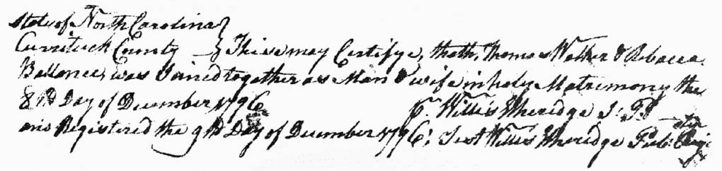