
Deed Book 3 begins in the 1730's, meanders backwards and forwards in time to the 1710's and 1750's, and then jumps abruptly into the first years of the nineteenth century. It contains the oldest group of deeds, which were recopied by the register and so noted. The recopying of the oldest deeds in Deed Book 3 resulted in the misinterpretation of the date of writing, presenting, and recording in the deeds. The reader will see that from time to time the dates of presentation in court are later than those of the original recording. One solution to this involves the practice of observing the old calendar versus the new. For instance, in Deed Bk. 3, pg. 13, it lists the dates as 19 Nov 1739, 1 Jan 1739 and 26 Mar 1739. The most reasonable explanation for this discrepancy is that the two latter dates should be written 1739/40, a facet of dating that was ignored by the nineteenth century clerks who recopied these deeds. At times, however, there is no explanation for a discrepancy in the sequencing of dates. Such must be attributed to scribal error. [A note at the beginning of the book says]: According to note p. 22 the below were copied herein in 1800. The middle of this book pp. 86 to 123 contains the earliest deeds of record in this county. They date from 1696 to 1713. The beginning from 1735 to 1740. The end from 1796 to 1805. Book two has 1761 to 1790 with a few re-recorded 1704 etc. deeds as on pp. 327 and 416 (1719).NOTE:
![]()
[Deed Book 3, pg. 1] John SQUIRES to George TURNER. April 9, 1739. ú20. Land on Marrismonkeete on
the No. side of Weesockin Creek...500 acres...Beg. at a gut on David JONES'
line rinning up the main creek to the head from thence a North course to a sweet
gum thence an easterly to the back of a Grate Savanah then to the first
station. /s/ John (x) SQUIRES, Charles (x) EDEN. Wit: Saml. STOW,
James (x) POYNER, John BROOKS. Acknowledged in open court by John SQUIRES Indian
King with Charles EDEN unto George TURNER.
Registered June 21, 1739.
[Deed Book 3, pgs. 1-2] John BUCKNER
to William HARDING. April 2, 1739. ú10 current money of Virginia. 50 acres commonly known by the
name of the Reedy Island Neck. /s/ John BUCKNER, Sarah BUCKNER. Wit:
Thos. DAVIS, Saml. BAKER, Edwd. (x) COX. Acknowledged by John BUCKNER
and his wife Sarah April 13, 1739. Registered June 21, 1739.
[Deed Book 3, pgs. 2-3] Joseph BELL to Solomon ETHERIDGE. Jan. 2, 1738. "Joseph BELL & Mary his wife
living in Cartrite precinct in the county of Bath." ú51 Virginia money. Land containing by
patent six hundred & sixteen acres which said land was granted to John
HOUDGSON
& son by patent bearing date the 25th day of February 1696 being...on the North
side of the Northwest branch of Tulls Creek. /s/ Joseph BELL, Mary BELL.
Wit: Richd. HODGES, Solomon BRIGHT. Ack. April 3, 1739. Reg. June 21,
1739.
[Deed Book 3, pg. 3] John SQUIRES &
Charles EDEN to Morris JONES. April 3, 1739. John SQUIRES King
of Aramateskeete Indians. ú12 Virginia money. 100 acres...from the head of
Seeder Creek to the head of the lone Creek running a South East course. /s/ John (x) SQUIRES,
Charles (x) EDEN. Wit.: Thos. LOWTHER, Saml. SIMMONS. Acknowledged
April 3, 1739. Registered June 28, 1739.
[Deed Book 3, pgs. 3-4] John SQUIRES
to David JONES. April 4, 1738/39. John SQUIRES King of
Arramaskeete. ú50 current money of Great Brittin. Land lying at Arramuskeet...beginning at a small gut binding
upon Saml. STOW & running as the main creek to a small creek called
Strahorn from thence to a small servana running up to the head of the
creek...250 acres. /s/ John (x) SQUIRES, Charles (x) EDEN. Wit:
Nicholas LUND, Saml. STOW. Ack. April 3, 1739. Registered June 28, 1739.
[Deed Book 3, pgs. 4-5] John SQUIRES
to Saml. STOW. John SQUIRES King of Arramaskeet Indians &
Charles EDEN. ú20 Sterling. Land...on the North East side of Weesocking Creek & so
along the said creek to the first gut that turns out upon the sd. Creek and from
thence back to a water oake and from thence to the head of Cedar Creek including
all the land within the said bounds. /s/ John (x) SQUIRES, Charles (x) EDEN.
Wit: Thos. LOWTHER, Saml. SIMMONS. Ack. April 3, 1739. Reg. June 28,
1739.
[Deed Book 3, pg. 5] Thos. COLLINS to Nickles LUND. Jan. 22, 1738/9. Thos. COLLINS of the precinct of
Pasquotank power of attorney to Nicklas LUND to appear at next court in
Currituck and "acknowledge in my Name one certain parcell of Land called Rowly
park lying on the North Banks". /s/ Thos. (x) COLLINS. Wit:
Robert (x) PAUL. Proved April 3, 1739. Registered Sept. 25, 1739.
[Deed Book 3, pgs. 5-6] Thos. COLLINS
to Joseph MIDYETT. Jan. 19, 1738. Thos. COLLINS of the precinct of
Pasquotank...planter...ú50. Land...on the North Sand Banks...Beginning at the
Southern line or creek & N.E. to John ARESES line...150 acres. /s/
Thos. (x) COLLINS. Wit: Nichlas LUND, Robert (x) PAUL. Acknowledged
April 3, 1739. Registered June 28, 1739.
[Deed Book 3, pg. 6] John SQUIRES to David JONES. Jan. 15, 1738/39. John SQUIRES King of the
Arramaskeet Indians. ú20 current money of North Carolina. 300 acres. Lying...on the south side of Rattel snake
homack creek and binding on the other side with the land of the afsd. JONES.
/s/ John (x) SQUIRES. [No witnesses listed]. Acknowledged April 3, 1739.
Registered June 28, 1739.
[Deed Book 3, pgs. 6-7] Wm. ETHERIDGE
to Owen DOCKETY. Oct. 2, 1739. Wm. ETHERIDGE, SENR. of Norfolk
County in Virginia. [Terms of sale illegible, but doesn't appear to be a sum of
money]. 100 acres. Being part of a tract of land formerly held by John MILLER
& patent bearing the date the 20th day of December 1716 the sd. land Joyning on
part of the same tract whereon George POWERS now lives. /s/ William
ETHERIDGE. Wit: Wm. CREEF, Otho HOLLAND. Acknowledged [no date
given]. Registered Oct. 20, 1739.
[Deed Book 3, pgs. 7-8] Thos. BRINT of
Currituck Precinct, Albemarle County to Jacob BARBER, of the same precinct. Nov. 8, 1720. ú5? lawful money of
England. 100 acres. On the Northwest side of a
branch of Brays Creek & being the half part of that same tract of land whereon
the sd. Thos. BRINT now liveth being the Northwest part of the same. /s/ Thos. (B:) BRINT. Wit: John ETHERIDGE, Marmaduke (x) ETHERIDGE.
Acknowledged July 3, 1739. Registered Dec. 21, 1739.
[Deed Book 3, pgs. 8-9] Patrick WHITE
to Wm. DUDLEY. Sept. 25, 1739. Patrick WHITE of Norfolk County in
Virginia. William DUDLEY of Knots Island in Currituck County. ú25.
Land...on Knots Island formerly Princess Ann County Virginia...100 acres.
Beginning at a sedar stake William WHITE's line upon the Bay side running
south 50 pole to William HARDING's line west and be North three hundred &
twenty poles the north to a hickory fifty pole then running East and be South to
the first station it being a peace of land my father bought of William WHITE,
it lying at the South East end of William WHITE's land. /s/ Patrick
WHITE. Wit: Hugh PURDY, Daniel DUKE. Acknowledged Oct. 2, 1739.
Registered Dec. 22, 1739.
[Deed Book 3, pg. 9] Zachariah JONES
to Capt. Caleb WILSON. Jan. 3, 1739. ú20 current money of Virginia. All my right title & interest I
have unto the within mentioned patent pursuant and agreeable to the Last Will
and Testament of my decd. father Samuel JONES onley excepting two deeds
allready made from the sd. patent: vizt: fifty each deed more or less and all
the remainder...unto the sd. Caleb WILSON. /s/ Zachariah JONES.
Wit: Daniel PHILLIPS, Wm. WHITE. Acknowledged Jan. 3, 1739. Registered
March 4, 1739. Daniel PHILLIPS witnessed a deed from Zachariah JONES to Caleb WILSON on January 3, 1739.
[Deed Book 3, pgs. 9-10] Zachariah JONES of Pasquotank County, ship carpender, to Caleb WILSON of Currituck County, merchant. Jan. 1, 1739. ú20 current money of Virginia. 200 acres more or less and 3 acres of marsh in Currituck Co. lying at the end of Holleys neck point on the south side of the norwes- river, begining at an ash standing on the north side of a branch called deep branch and runing up the said branch west south west two hundred poles then norwest to a pine in Capt. MARCHANTs line, then down the said line to a reedy branch then down the said branch to a pine being the south east corner of the said Capt. MARCHANTs land. Except two small tracts that was sold out to Wm. SCOOT one of them containing thirty acres more or less and the other twenty acres more or less as mentioned in the said SCOOTs deed and fifty acres more or less which BRICKHOUSE hold by deed and bounded as is mentioned in the said BRICKHOUSE deed. /s/ Zachriah JONES. Wit: Daniel PHILIPS and Willm. WHITE. Proved in court the 3 day of January 1739. Registered the 4 day of March 1739.
[Deed Book 3, pgs. 10-11] Zachariah JONES of Pasquotank County, ship carpendar, to William SCOTT of Currituck County. Jan. 1, 1739. ú50 current money of North Carolina. Two tracts of land lying in the county of Currituck and in the province of North Carolina one of the said tracts of land containing by estimation thirty acres more or less begining at the mouth of a branch called Holleneck branch to a marked white gum and standing on the head of the said branch thence on a direct line to a holly on the pocason to the first station: the other tract of land containing by estimation twenty acres more or less begining at an elm tree and by runing southwest to a beach tree to binding to BOLDING line of marked trees. /s/ Zachariah Jones. Registered Jan. 3, 1739. Test: Wm. Shergold Clk. court. Test: Wm. Shergold and Daniel Phillips.
[Deed Book 3, pg. 11] John SMITH to Richd. SMITH. Nov. 20, 1739. I John SMITH Negro of North Carolina in the county of Albemarl planter have named and constuted and by these presents do name and ordain apoint and make my son Richd. SMITH Negro of the county above named county my true and lawfull attorney for and in my name and to my use to demand sue and recover or bargains or in making over in courts lands or tenements giving and hereby granting unto my said attorney my full power and authority to use and exersise all such etc. things and devices as shall be necesary for the acknowledgeing lands or tenements and generally to do executing peremises. /s/ John SMITH, Joaneth [her mark] SMITH. Wit: Saml. BAKER and Jacoby LOOT. Reg. the 7 day of May 1740 by Thos. WILLIAMS Pub. Registar.
[Deed Book 3, pgs. 11-12] Thos. SEARS to Evan MILLER. Jan. 2, 1739. Thos. SEARS of Currituck county in North Carolina of the one part and Evan MILLER in the same county of the other part, the sum of 5 shillings a tract of land containing Seventy one and twenty two chains and bounded as followeth. Begining at a black gum and runing north 55 degrees east 35 pole thence south thirty degrees east seventy pole to a pine thence south twenty degrees west thirty two pole to a pine thence south fifty degrees west forty pole to a black gum thence through the swamp by its vearious courses to the begining station. /s/ Thos. SEYRS. Wit: Andrew DUKE and Wm. SHERGOLD. Acknowledged in open court from Thos. SAYRS and his wife Barbary the first day of Jan. 1739. Registered May 23, 1740.
[Deed Book 3, pgs. 12-13] John SMITH to Jacob LOUTS. Nov. 19, 1740. John SMITH free negro of the presinck of Currituck in the county of Albemarle and in the provience a for said of the one part, for the sum of five pounds Spanish to me in hand paid and secured to be paid by the Jacob LUTS the recipts where I do hereby acknowledge and impower my son Richd. SMITH and make him my attorney. A tract of land on the North River swamp begining at a pine going east by a line of marked trees to a pine at the head line and from thence a southerly courses to a white oake a corner tree along the head line and from that corner tree a westerly course by a line of marked trees to a white oake as a corner tree as a for said containing one hundred acres of land more or less. /s/ Richd. SMITH. 1 day of Jan. 1739 Wit: Wm. ODOWDY, Mick MILLER. Registered 26 day of May 1740.
[Deed Book 3, pgs. 13-14] John SMITH to Samuel BAKER. Nov. 19, 1739. John SMITH Negro of the prect. of Currituck in the County Albemarle and in the prect. of North Carolina and Samuel BAKER of the same prect. and county and province a for said, for the sum of five pound in hand paid and secured to be paid. A tract of land containing one hundred acres more or less situate lying and being in the prect. of Currituck in the county and provence a for said do by these presents impower Richd. SMITH free Negroe to make over the said tract of land joying and binding on the North River swamp. Begining at a read oake corner tee and so runing an east course by line of marked trees to a pine a corner tree at the head line and from thence a south course along the head to a pine a corner tree and from thence a line of marked trees a west course to a pine a corner tree at the swamp side the a for said containing one hundred acres more or less. 10 day of Jan. 1739. /s/ Richd. SMITH. Wit: Test: William DOWDY, Mick MILLER. Registered the 26 day of May 1739.
[Deed Book 3, pgs. 14-15] Judy MIDGETT of Currituck County to Judy MIDGETT of Currituck County. Mar. 14, 1739. ú20 current money, a tract of land in Currituck County called Hawtree Point and lying on the North Sand Banks containing 70 acres butted and bound as followth begining at Frances Creek and runing north along the sound side to a little creek and east back to the head line and so along to the first station. . /s/ Judy MIDGETT Wit: Nickles LUND, Jean [her mark] NEALE. The above deed was acknowledged in open court by Nickles LUND one of the subscribing evidences unto Judith MIDGETT the 3 day of April 1739 and was ordered to be registered. Registered June 10 1740.
[Deed Book 3, pgs. 15-16] Luke & Margret WHITE of Currituck County to William WHITE of Currituck County. We Luke and Margaret WHITE for divers consideration here unto moving but more especially the pertickuler love and natural we have and bear unto our loving son William WHITE, a deed of gift of that plantation of ours joying on the south side of a plantation now James POYNERs with two hundred and thirteen acres of land joying to the same according to the bounds here after expreict sittuate lying and being in the county province a for said on the west side of Currituck bay Begining at the bay side in the line parting the premises and a for said James POYNER land then westerly to the head line then southerly with the line as fare as will make up the a for said two hundred and thirteen acres then down as that course to the bay side then down the bay norwardly to the first being two hundred and thirteen acres of land as the same now is or forever here after shall be it being part of a grate tract of land formerly taken and patented by Richard COMMINFORD late of the county and province decd. /s/ Luke WHITE, Margret [her mark] WHITE. Wit: Elizabeth WHITE, John BROOKS. This above deed was acknowledged in open court by Luke WHITE and his wife Margrett unto their son William WHITE the 3 day of Jan. 1739 and was ordered to be registered. Registered 10 day of June 1739.
[Deed Book 3, pg. 16] Col. Robert WEST to Thos. DUDLEY, SENR. Apr. 8, 1738. I Coll. Robert WEST of Bartie prect. in the province a for said for one hundred and thirty pounds to me in hand paid by Thos. DUDLEY SENR. of Currituck prect. An Island in Currituck sound containing by estimation one hundred and ten acres be the same more or less commonly known by the name of Crow Island which Island was bequethed to me by the last will and testament of magor George POLLOCK of Bartie prect. deceasd. /s/ Robert WEST, Francis WEST. Wit: Nathaniel MARTIN, John DUDLEY. This above deed was acknowledged in open court from Thos. DUDLEY and wife the 3 day of April 1740. Registered the 7th day of May 1740.
[Deed Book 3, pg. 17] Thos. VINCE & wife Margett VINCE to Luke WHITE. Apr. 12, 1714. Thos. VINCE and his wife Margett VINCE of the prect. of Currituck in the county of albemarle and in the province of North Carolina and Luke WHITE of the same county and province a for said, for ú20 sterlin, one plantation or tract of land containing by estimation one hundred and forty and three acres lying and being near poyny point on the south side of the said point and in the prect. and provence of North Carolina a for said, Begining at a pine tree then a straight course one hundred and forty pole down to the marsh then along the river by various courses as the said river runeth thence up in the woods one hundred and twelve pole to a read oake then eighty poles to the first station containing one hundred forty and three acres a for said as by aplate to him the said Thos. was laid out being part of a biger tract of land patetned to Anne BALY dated 21 day Feb. 1696. /s/ Thos. VINCE, Margett [her mark] VINCE. Wit: Thos. VANDERMULIER, Thos. TOLLER. The above deed was acknowledged in open court by Thos. VINCE and his wife Margrett unto Luke WHITE the 3 day of ApriL 1740. Registered 17 day May 1740.
[Deed Book 3, pgs. 17-18] William WILLIAMSON & wife Ann to Caleb WILSON. March 4, 1739. William WILLIAMSON and wife Ann of the county of Currituck in the province of North Carolina in consideration of the sum of ú10 current money of North Carolina in hand paid by Caleb WILSON of the said county and province a for said. One certain peace of land situate and lying in Moyock containing fifty acres more or less begining on a beverdam at a lobed marked poplar and so runing up a line west south west or there abots to a gum on Andw. ETHERIDGE line and thence ruing up his line to a run to a marked beach it being a peace or parcell of land that the said WILLIAMSON bought of Thos. SCOFIELD. /s/ William WILLIAMSON, Ann [her mark] WILLIAMSON. Wit: Willis WILSON, Joseph STEWART and Stillman SIKES. Acknowledged in open court the first day of Apr. 1740. Registered 17 May 1740.
[Deed Book 3, pgs. 18-19] John SQUIRES, King and Charles SQUIRES by and with the consent of the Aramoskeet Indians, sold to Joshua WALLS of Currituck Co., for ú20 current money of North Carolina, a parcel of land lying in Hogg Island Bay commonly known by the name of Mount Pleasant. Beginning at a large pine that was marked by the white folks and the Indians, running across the ridge to the Swamp and so along the Swamp Side containing 200 acres, more or less. This deed was made April 3, 1740. /s/ John [S] SQUIRES; Charles [S] SQUIRES. Witnesses: William SHERGOLD; William PARKER. Registered June 17, 1740.
[Deed Book 3, pg. 19] John ETHERIDGE to James BIGGS. Dec. 9, 1739. I John ETHERIDGE a publick Treasurer for the county of Currituck for ú50 current money of North Carolina to me in hand paid by James BIGGS of said county, planter, for fifty acres of land more or less. /s/ John ETHERIDGE Treasurer, Wit: Cornelius JONES, Richd. CHURCH. Acknowledged in open court by John ETHRIDGE Treasury unto James Biggs the 3 day of April 1740. Registered 17 day of June 1740.
[Deed Book 3, pgs. 19-20] Solomon ETHERIDGE and wife Tamer to John ETHERIDGE. March 8, 1739/40. Solomon ETHERIDGE and wife Tamer living in Currituck county county of Albemarle province of North Carolina and John ETHERIDGE of the same county and province a for said. The sum of thirty four pounds six shilling and eight pence Virginia money. A certain tract of land one hundred and eleven acres more or less. Begining according to the bounds of the deed patent on the North side the northwest branch of Tuls Creek and so runing up this run by virious courses to a gum according to the patent and then through the low grounds or swamp according to the bounds of Saml. LUS and the said land then down the said stream by various courses to the main run then down the main run by various courses to the first station, it being part of a tract of land which was formerly granted to John HUDGSON by patent bearing date the twenty fifth day of Feb. 1696. /s/ Sallomon ETHERIDGE, Tamer [her mark] ETHERIDGE. Wit: Job ETHERIDGE and Elizabeth NORTHERN. Acknowledged the 3 day of April 1740. Registered the 17 day of May 1740.
[Deed Book 3, pgs. 20-21] Alexander LEFTYEAR to Enoch MILLER. July 1, 1738. North Carolina Currituck County. I Alexander LEFTYEAR for ú80 to me in hand paid by Enoch MILLER. A parcell of land lying in Currituck prect. Being fifty acres out of the two hundred acres of land I bought of Mr. Richd. SANDERSON, fifty acres more or less, begining at a black oake a corner tree binding on the Indians line and from thence to a forked pine standing in the edge of a sevenah and from thence to a sweet gum binding on Momele? LEFTYEARs line and the main road. /s/ Alexander LEFYEAR. Wit: John BEMBERIGE SENR., John BEMBERIGE. Acknowledged 3 day of Apr. 1740.
[Deed Book 3, pg. 21] Hezekiah FARROW to Jacob FARROW. May 5, 1736. Hezekiah FARROW of the prect. of Currituck in the county of Albemarle and province of North Carolina and Jacob FARROW of the prect , county and province a for said. for ú50 sterling money, Land lying and being on the sand banks in the prect. a for said near Cape Hatteras containing one hundred and thirty five acres be the same more or less. being bounded as followeth begining at the sound at a creek called deep creek and runing a stright east course across to the sea side thence Northwardly along the sea side abrest of asskins [sic] hill thence westerly across by the said hill to the sound then along the sound to the first station, being a part of a tract of land containing 270 acres granted to Francis FARROW by patent baring date Dec. 19 1716. /s/ Hezekiah FARROW. Wit: Job CARR, J. MARTYN. Acknowledged in open court by Hezekiah FARROW unto Jacob FARROW the 3 day of Apr. 1740. Registered 26 of June 1740.
[Deed Book 3, pg. 22] John SQUIRES, King of the Mattamuskeet Indians and Charles SQUIRES to Jacob FARROW. April 2, 1740. ú100 for 400 acres of land lying and being in Aramoskeet in Currituck Co. beginning at William BROWNINGs line and running northward to Joshua WALLS' line and ending at the Sypries Swamp Creek. /s/ John [S] SQUIRES. Wit: Cornelius JONES; Thomas DUDLEY. Registered June 26, 1740.
[Deed Book 3, pgs. 22-23] George TURNER of Currituck Co. to Samuel SELLBY of Currituck Co. April 2, 1740. ú500 current money of North Carolina to me in hand paid by Samuel SELLBY of the county and province afsd.. Land lying in wassocking by estimation two hundred and fifty acres more or less and bounded as followeth, begining at the mouth of a creek that was formerly belonging to David JONES so runing up the said creek to the mouth of a small gutt between the said SELLBEY house and the said George TURNERs house then a north and be west course to the main swamp then on east course to the head of the said David JONES former line so runing along that line to the first station. /s/ George TURNER. Wit: Wm. SHERGOLD, Moris JONES. Acknowledged 3 day of Apr. 1740. Registered the 26 day of June 1740.
[Deed Book 3, pg. 23] John & Charles SQUIRES to William BROWNING. June 24, 1739. John SQUIRES and Charles SQUIRES by and with the free and willing consent of all the rest of the Mormeskeet Indians in the county of Currituck and province of North Carolina of the one part and William BROWNING of the other part of the afsd. county and province. For the sum of ú10 sterling money of Great Britian. Land lying and being on Mormoskeet afsd. upon hogg Island on a ridge commonly called the English Mount Pleasent lying on the south end of a ridge begining at a grate poine tree marked by the Indians and from thence on east containing estimation five hundred acres of land. /s/ John SQUIRES and Charles SQUIRES. Wit: Wm. SHERGOLD, T. LOWTHER. Acknowledged the 3 day of April 1740. Registered 26 day of June 1740.
[Deed Book 3, pg. 24] Jacob FARROW to Charles SQUIRES. April 2, 1740. I Jacob FARROW for the sum of ú100 lawfull money to me in hand paid by Charles SQUIRES Indian of Arrowmuskeet in the county of Currituck in the province afsd.. Two hundred acres of land lett the same be more or less lying and being on Hatteras Banks in the county and province afsd. and bounded as followeth that is to say begining at the North side of the cutting sedge marsh as is by the house that Vallintine WALLIS built on the said banks so runing to the sound side and so back to the first station. /s/ Jacob FARROW. Wit: Cornelius JONES, Thos. DUDLEY. Registered the 22 day of Aug. 1740.
[Deed Book 3, pgs. 24-26] John DURANT to John CARRONE. I John DURING King of the Opim Indians and of Currituck County for ú750 starling money of Greate Brittian in hand paid to me by Capt. John CARRONE of the same province and county afsd. the recipt whereof I do hereby with consent of the governor and counsill acknowledge my self there with fully satisfied and paid. A parcell of land on the North River on the in the county afsd. begining according to the courses of the patent bearing date Oct. 1714 containing five thousand acres by the same more or less excepting fifty acres to be laid out of the said qantaty [quanity] on this corner of the eastmost line. And I John DURANT with the consent of governor and counsell by order baring the twenty second of day Feb. 1739 for myself and the rest of the Nation do covenant promise and grant to and with the said John CARRON. /s/ John [his mark] DURANT, James [his mark] BARBER, Thos. [his mark] DURANT. Wit: Andrew DUKE, John LURRY, Edw. COX. Acknowledged 7 day of Oct. 1740. Registered 9 Jan. 1740 [should be 1741].
Know all men by these presents that wee John DURANT King of the eopim Indians and Thos. DURANT my son and James BARBER Indian of the same Nation and county afds. held firmly unto Capt. John CARON of the said county and province asfd. in the full and trust sum of ú1500 sterling money of Grate Britian to be paid unto the said John CARON his heirs Execs. Adms. or assigns or certain attorney to which payment will and truly to be made and done wee bind our selves our heirs Execs. Adms. firmly by these presents. /s/ John [his mark] DURANT, Thos. [his mark] DURANT, Thomas [his mark] BARBER. This above Bond form John DURANT Indian King was acknowledged in open court to Capt. John CARRON and at the prayer of the said CARON it was ordered to be registered. Test: Wm. SHERGOLD, Clk. court. Registered 14 day of Dec. 1740.
[Deed Book 3, pgs. 26-27]
Mary
RUSSELL to Thos. GRAY. July 5, 1737. Mary RUSSELL
of the province of North Carolina of the one part and Thos. GRAY of the
said province. For the sum of
ú90
lawfull money of the said province. All that plantation or tract of land
containing by estimation one hundred and forty seven acres be it more or less
being one part of a tract of land which one William RUSSEL purchased of Edward JELFE containing four hundred and forty seven acres and joying
upon the land where on one Thos. RUSSELL formerly dwelt, begining at
marked tree stands by the sound side thence by a line of marked North twenty
eight degrees east three hundred and twenty poles into the woods thence east
thirty six degrees south seventy three poles thence south twenty eight degrees
west on a line of marked trees to the sound thence along the sound various
courses to the first station. The said Mary RUSSELL at the time of
sealing and delivering of this indenture of sail am hole and sole owner of all
and singuler the premises in my own proper right as a good and perfectt and
absolute estate of inheritance in fee simple. /s/ Mary [her mark]
RUSSELL. Wit: Saml. WILLIAMS, Jacob FARROW.
Acknowledged by
Thos. GRAY unto John APPELLSTATE the 7 day of Oct. 1740.
Registered the 15 day of Jan. 1740 [sic].
[Deed Book 3, pgs. 27-28] John DURANT to Edward TAYLOR. November 27, 1740. Both of Currituck. Edward TAYLOR listed as planter. John DURANT is listed as the King of the Yowpinn Indians. Twenty-two pounds, ten shillings current money of Virginia. Fifty acres in Currituck. Bounded by corner of Jeremiah STEPHENS plantation; Land now in possession of said Edward TAYLOR by virtue of a lease to him thereof made by the said John DURANT bearing the date the day of November (sic) one thousand seven hundred and thirty-one and is also part of a bigger tract of land formerly granted unto the King of the Yeopim Indians by patent bearing date of October, 1704. /s/ John (his x mark) DURANT. Wit: T. LOWTHER, Elizabeth (her x mark) TAYLOR. Acknowledged in open court January 1740
[sic]. Registered February 10.
[Deed Book 3, pg. 28] Thos. ALLEN to Phillip WILLIAMS. ____ 1740. Thos. ALLEN of the County Currituck in the Provence of North Carolina for and in consideration of ú10 to me in hand paid and secured to be paid by Phillip WILLIAMS. Land lying and being on the sand Banks in the county afsd. bounded as foloweth, begining at a live oak hamock at the head of Jennyses Cove and so runing Northwardly to the land of Wm. JERVIS? /s/ Thomas ALLEN. Wit: William JARVIS, George POWERS. Acknowledged 7 day of Oct. 1740. Registered 13 day of Feb. 1740 [sic].
[Deed Book 3, pg. 28] John SQUIRES & Charles EDEN to Wateman EMEREY. Oct. 9, 1740. John SQUIRES king of the Aromoskeete Indians and Charles EDEN for in consideration of the sum of ú100 lawfull money of the afsd. province to us in hand paid by Wateman EMEREY. 640 acres of land and bounded as followeth, Begining at the mouth of Back Creek runing a mile west southwest corse then along pampleco sound to seader bush creek then from the creek a mile. /s/ John [his mark] SQUIRES. Wit: Thos. LOWTHER, Andrew DUKE. Registered the 14 day of Feb 1740 [sic].
[Deed Book 3, pgs. 29-30] Caleb WILSON to William WILLIAMS. April 1, 1740. Caleb WILSON of Currituck county, Merchant, for ú50 current money by William WILLIAMS of the county and province afsd. Land containing by estimation fifty acres more or less being part of that tract of land that the said WILSON bought of Zachariah JONES and bounded as followeth, begining at WILLIAMS east line at a holley and so along the percoson to a white gum then along the Branch to a persimon then southwest course by aline of marked trees to a holley then about an east course to an oak, Joying to Daniell PHILLIPS then from the said oak to the first station. /s/ Caleb WILSON. Wit: Jonathan POINER, William MUNCREEF. Acknowledged 8 Apr. 1740. Registered 14 Feb 1740 [sic].
[Deed Book 3, pg. 30]
John
SQUIRES & Charles EDEN to James BAKER. Jan. 28, 1740.
Know yee that we John SQUIRES King of the Arrowmoskets Indians and
Charles EDEN for in consideration of the sum of
ú8
Virginia money paid by James BAKER of the afsd. province. 200 acres of
land bounded as followeth: begining at the south side of Back creek then runing
west south west through the woods into a servanah then runing North to another
servanath then runing an east course to pampleco sound side. /s/ John
[his mark] SQUIRES. Wit: Thos. LOWTHER, Henry GIBS JUNR.
Registered
16 Feb. 1740.
[Deed Book 3, pg. 31] Joseph BOWREN to Gideon WHITEHURST. July 1, 1740. Twenty shillings. BOWREN of Currituck and WHITEHURST of Virginia. Thirty-five acres
lying and being in
the county Currituck and province of North Carolina afsd. Begining at a gum
standing on the east swamp side and so runing northerly a line of marked trees
to a popler corner tree of John CRABs thence along the said CRABs
line to an oake then along Peter DAUGE's line then on it corse to
Richd. STONEs corner tree then runing along the said STONEs line
easterly to the swamp then along the said southerly by natural corses to the
first station.
/s/ Jos. BOWRIN.
Wit: Saml. SIMMONS, John SHIP. Acknowledged July 1, 1740. Registered January 5, 1740
[sic].
[Deed Book 3, pg. 31] Tulle WILLIAMS & Thos.
TAYLOR. "The deposition of Tulle WILLIAMS of Perquimans County and of the province aforesaid and of Thos. TAYLOR of Pasquotank County also aforesaid province planters being
first duly sworn on the holy evangless deposeth and saith that on or about the fourth day of January one thousand seven hundred and thirty-six at Currituck County in the province aforesaid one Stephen WILLIAMS of the said County did give and bestow unto his brother Thos. WILLIAMS of the County and province aforesaid a certain Negroe called by the name of Dinath unto him the said Thos. WILLIAMS during his life and after
his decease the aforesaid Negro girl to be given to the son of Thos. WILLIAMS one Wm. WILLIAMS and his heirs forever and further these deponents saith not." Sworn before me the 12th day of November 1740. David BALLEY. /s/ Tulle WILLIAMS. Thos. TALLER. Registered the 15th day of March 1740
[sic].
[Deed Book 3, pg. 32] Horasha WOODHOUSE to Wm. MACKEY. April 4, 1740. I Horasha WOODHOUSE of Hewies River in North Carolina do here by constitute and appoint my trusty friend Mr. Wm. MACKEY of Currituck county in the above said province to be my lawfull attorney to make and acknowledge in Currituck prect. courts deeds for one hundred and fifty acres more or less lying and being on Island called Mackeys or Jons Island and is the same land that I bought of Mr. Wm. MACKEY my said attorney and Peter MARLBIN of Princes Anne county Virginia and I do give my said attorney as full and ample authority in all things relating to the said land for the coveyence and shore making over the same with the appurtenance unto Mr. Matthew ALLEGOOD of Princess Anne county in Virginia in absolute fee simple as I my self cold [could] or might do were I personally present in comatation of this my above said power of attorney. /s/ Horasha WOODHOUSE. Wit: Wm. KEELING SENR., Laml. CORNICK, Wm. KEELING.
[Deed Book 3, pg. 32] Thomas MUNCREEFE to John MUNCREEFE. Aug. 16, 1740. I Thomas MUNCREEFE for the love and effection I bare to my son John MUNCREEFE do give unto him eighty acres of land it being half the land and plantation where on I now live, begining at the old plantation line so into the plantation to the mouth of a ditch by sider post then runing a strate course out to the back line agreable to those lines, likewise I give to my son John all the cattele in his marke male and female and one bay mare and colt and an chest lock and key comonly called his one desk one bason three plates, the above artickles I do give to my son John MUNCREEF his heirs Exec. Adms. forever from me my heirs Exec. /s/ Thos. MUNCREEFE. Wit: Isaac DAVIS, Elizabeth CREEFE. Acknowledged Oct. 1740. Registered 8 day Oct. 1740.
[Deed Book 3, pg. 32] Thos. SCOFELD to Saml. WILLIAMS. Thos. SCOFELD for the sum of ú3 to me in hand paid by Saml. WILLIAMS, a parcell of land lying in Currituck county northen sand Banks between Currituck Inlet [this is all there is to this deed, a line was drawn and the next deed started]
[Deed Book 3, pgs. 32-33] John SQUIRES & Charles EDEN to Joseph PERSONS. Apr. 3, 1739. We John Squires King of Aromoskeet Indians and Charles Eden for the sum of ú11 lawfull money of North Carolina to us paid by Joseph PESSONS [sic], for two hundred acres of land and bounded, begining at marked pine upon a ridge called Mountplesent so runing across the ridge to a marked sweet gum then runing from the said sweet gum a south east corse to complete two hundred acres. /s/ John [his mark] SQUIRES, Charles [his S mark] EDEN. Wit: T. LOWTHER, Saml. STOW. Acknowledged 3 day of April 1739. Registered 28 day of June 1739.
[Deed Book 3, pg. 33] Thos. COLLINGS to Nickolas LUND. Jan. 19, 1738/39. Thos. COLLINGS of the Prect. of Pasquotank and in the province of North Carolina by these presents make ordain apoynt my friend Nickolas LUND of Currituck prect. in province of North Carolina my true and lawfull attorney for me and in my name and stead to appear for me at our next court held for this prect. Currituck after the date here of and ther to acknowledge in my name a deed for land lying on the Banks in Currituck prect. called Rowsepock. Granting unto my said attorney authority. /s/ Thos. [his mark] COLLINGS. Wit: Joseph MIDGETT. Registered 13 Sept. 1739.
[Deed Book 3, pgs. 33-34] Thos. COLLINGS to Robert PAULE. Jan. 20, 1739. Thos. COLLINGS of the prect. of Pasquotank and in the province of North Carolina planter for ú60 paid by Robert PAULE of the prect. of Currituck in province of North Carolina. A certain percell of land called Rowspock containing two hundred and fifty acres more or less lying and being in Currituc prect. on the North Banks, begining Rowspock point and runing long the sound side to Lemors Southen Creek and binding on Ralph MARTANs line and Charles THOMAS and so along the run to the first station. /s/ Thos. [his mark] COLLINS. Wit: Nicklos LUND, Luranh SAVELL, Robert PAULL. Acknowledged the 3 of Apr. 1739. Registered 25 Sept. 1739.
[Deed Book 3, pgs. 34-35] John SQUIRES & Charles EDEN to Thos. LOWTHER. Apr. 3, 1739. I John SQUIRES King and Charles EDEN of Aromoskeet Indians for the sum of ú30 good and lawfull money paid by Thos. LOWTHER. A certain tract of land lying and being part of the Indian Town old field of Aromoskeete and joying on John DISEOR line on one side to the north and bounded to the south side with marked popler next to the sound side and thence runing from the said popler towards the lake a stright course including all the land within said bounds. /s/ John [his mark] SQUIRES, Charles [his mark] EDEN. Wit: Saml. SIMMONS, Saml. STOW. Registered 1 Day of Nov. 1739.
[Deed Book 3, pg. 35] Phillip & Elizabeth NORTHERN to Thos. LOWTHER. Apr. 4, 1739. We Phillip NORTHEN and Elizabeth NORTHEN wife of said Phillip for the sum of ú35 Virginia money. A tract of land called by the name of WILLIAMS plantation and lying and being upon Moyock creek in Currituck County which said plantation was given to the said Elizabeth NORTHERN by her decesd. father Thos. MILLER as by said MILLERs will. /s/ Phillip NORTHERN, Elizabeth [her mark] NORTHERN. Wit: Isaac DAVIS, John LINTON. Acknowledged the 3 day of Apr. 1739. Registered 1 Nov. 1739.
[Deed Book 3, pgs. 35-36] John SQUIRES to John SIMONS. Apr. 4, 1739. I John SQUIRES King of Marremoskeet Indians for the sum of ú50 current money paid John SIMONS the county of Norfolk in Virginia. A certain percel of land lying between old arromoskeete and new arromoskeete lying between the seader hamock binding on Wm. SPENCERs the westmost part of the creek containing 300 acres more or less. /s/ John [his mark] SQUIRES. Wit: Nickles LUND, David JONES. Acknowledged the 3 day of Apr. 1739. Registered 1 Nov. 1739.
[Deed Book 3, pg. 36] Phillip NORTHERN to Robert PAULE, JUNR. July 4, 1739. I Phillip NORTHERN for the sum of ú6 current money of Virginia paid by Robert PAULE, JUNR. A peice of land begining Currituck County near to Kittyhawk bay and joining on the land called Rich. SMITHs which land was given to me the said Phillip NORTHERN by my decd. father John NORTHERN last will and testament when had relation to will more at large appears that is to say one hundred and twenty five acres be the same more or less together with all houses edifies and all appurtenences belonging to the said piece or parcel of land. Elizabeth the wife of me the said Phillip NORTHERN do renounce all right of dowry and power of thirds. /s/ Phillip NORTHERN, Elizabeth [her mark] NORTHERN. Wit: Thos LOWTHER, William POYNER. Acknowledged 3 July 1739. Registered 15 Nov. 1739.
[Deed Book 3, pg. 37] John BUCKNER to Wm. MANNING. July 3, 1739. I John BUCKNER for the sum of five shillings sterlinig paid by Wm. MANNING of the Colloney of Virginia. Land lying in Currituck County and part of the land I bought of Capt. John GIBBS bounded as followeth, begining at a stooping hickory and runing south 102 pole to a gum and from thence east 132 poles to a white oake in the swamp thence North 132 poles to a popler thence west 132 poles to the begining being one hundred acres. And Sarah wife of the afsd. John BUCKNER doth hereby renounce all right of dowery and thirds unto the demised premises. /s/ John BUCKNER. Wit: Thos. LOWTHER, Roger DOBBS?. Registered 16 Nov. 1739.
[Deed Book 3, pgs. 37-38]
John
BUCKNER to Robert SURLS SENR. June 13, 1739. John
BUCKNER of Currituck county of North Carolina of the one part and Robert
SURLS SENR. of the other part. John BUCKNER for divers causes
and consideration him there unto moving doth sett unto the said Robert SURLS
SENR. one tract of land called and known by the name of the neck adjoining
to the back old fields and being part of the land next to Reedy Island neck it
being allready bounded by marked trees. Robert SURLS SENR. doth further
promise covenant and agree to and with the said John BUCKNER that he will
not sell lease or put any person or persons upon the said land without the
subscribers leave or consent except some of his family. /s/
John BUCKNER.
Wit: Robert SERLS JUNR., Keader MARCHENT. Registered 22 Nov. 1739.
[Deed Book 3, pgs. 38-39] July 2, 1739. John SQUIRES King of the
Arramuskeet Indians with the advice and consent of John MACKEY and Long TOM in the County of Currituck and in the province of North Carolina the one party and Henry GIBBS of Currituck on the other for ú100 Land on a ridge called the Indian Ridge. No names listed as adjoining landholders. /s/John
[his x mark] SQUIRES. Wit: John TAYLOR, James [his x mark] BAKER. This above deed was acknowledged in open court by John TAYLOR one of the subscribing evidences the second day of October
1739 unto Henry GIBBS. Registered November 27, 1739.
[Deed Book 3, pg. 40] James & Sarah NICKOLS to Robert OVERTON. Jan. 1, 1736/7. James NICKOLS together with the free and ailling consent of his wife Sarah both living in the presint of Currituck and Robert OVERTON of Pasquotank prect. of the other party. The said NICKOLS for ú20 sterling money of greate Brittan paid Robert OVERTON . Tract of land containing fifty acres more or less. Begning at a beach runing norwest by aline of marked treed to a holley thence southwest joyning or to Elizabeth BRITEs line to a beach thence east by a line of marked trees to the first station beach and to according to the severall bounds to make up the said land afsd. /s/ James NICHOLS, Sarah [her mark] NICHOLS. Wit: Andw. ETHERIDGE, Job ETHERIDGE.
[Deed Book 3, pgs. 40-41] Joseph SANDERSON to Henry JARVIS. Jan. 5, 1735/6. Capt. Joseph SANDERSON of the prect of Currituck in the provence of No. Carolina of the one party and Henry JARVIS of the prect. and province afsd. of the other part. For five shillings current money of Virginia paid by Henry JARVIS. One plantation situate lying and being on the north east side of No. River in the prect. afsd. called by the name of Drapers Begining at a read oak jouning to a branch which devidth the said land and the Indian Town thence into the woods No. twenty two degrees east three hundred and twenty pole thence so. eighteen degrees east two hundred poles thence south seventy two degrees west three hundred twenty poles to the river side thence along the said river north eighteen degrees west two hundred poles to the first station containing four hundred acres. /s/ Jos. SANDERSON. Wit: Francis MORSE, Dayley LATTER.
[Deed Book 3, pgs. 41-42] Saml. SIMMONS to Henry SIMMONS. Sept. 29, 1736. Samuel SIMMONS of the prect. of Currituck in the county of Albemarl in the province of North Carolina Eldest son and heir of Saml. SIMMONS late Currituck afsd. decsd. of one part and Henry SIMMONS of the prect. of Currituck and county and province afsd. of the other part. for the sum of ú15 current money of Virginia. Land containing by estimation one hundred acres situate lying and being in the prect of Currituck in the county of Albemarl and in the province of North Carolina the said bargained premises commonly called and known by the name of Brooks Ridge being part of a certain tract of land surved and patenred by Saml. SIMMONS Decd. binding on the grate swamp and joining on the end of a certain ridge commonly known by the name of gum ridge. /s/ Samuel SIMMONS. Wit: Moses LINTON, Wm. GLASCOE.
[Deed Book 3, pgs. 42-43] Phillip EVANS to Joseph SANDERSON JUNR. Feb. 4, 1736/7. Phillip EVANS of Currituck perct. in the county of Albemarl and province of North Carolina planter of the one part and Jos. SANDERSON JUNR. of the same prect. county and province gent. Phillip EVANS for and in consideration of an exchange of a plantation called deep Branch to me delivered before the ensealing here of the recipt where of I do here by acknowledge. One certain plantation or percel of land commonly called Populer Branch plantation lying in Currituck prect. near Currituck narrows containing one hundred and fifty acres being bounded as followeth begining at the mouth of Poplar Branch creek from thence to a Branch called Sandy Branch and so along the said branch to the back line to a pine thence along the back line a southerly course to a pine thence southeast to Currituck sound thence along the said sound to the first station. /s/ Phillip [his mark] EVANS. Wit: Thos. LURRY, Thos. SANDERSON. Acknowledged in court 5 day of Apr. 1737.
[Deed Book 3, pgs. 43-44] Joseph SANDERSON JUNR. to Phillip EVANS. Feb. 10, 1736/7. Joseph SANDERSON JUNR. of Currituck Perct. in the county of Albemarl and province of North Carolina gent and Phillip EVANS of the same perct. county and province planter. Witness that I Jos. SANDERSON for and in consideration of an exchange of a plantation called Popler Branch plantation to me already delivered. One certain plantation and land there unto belonging containing one hundred acres begining at the eastward swamp and runing across by the widows path to the westward swamp then along the westward swamp to a Pine thence on easterly course by the end of the new road to the eastward swamp thence along the eastward swamp to the first station being one hundred acres more or less being part of a parcell of land given to the said Jos. SANDERSON JUNR. by his father Joseph SANDERSON SENR. as by deed bearing sate May 28 1733. /s/ Jos. SANDERSON. Wit: Thos. LURRY, Thos. SANDERSON. Jos. SANDERSON appeared with his wife and acknowledged this deed in court 6 Apr. 1737.
[Deed Book 3, pgs. 44-45] Thos. LURRY to Henry JARVIS. March 22, 1736/7. Thos. LURRY of Currituck prect. in the county of Albemarl and province of North Carolina and Henry JARVIS of the same prect and province. Thos. LURRY for the sum of ú35 good species of the said province. One parcel of land containing one hundred acres called RUSSELLs old field lying in Currituck prect. near the narrows being bounded as followeth begining at marked pine on Grandys Island creek side between Thos. LURRYs and Thos. SANDERSONs lands thence a westerly course along the dividing line to the head line to a ditch? to the first station. /s/ Thos. LURRY. Wit: Samuel WILLIAMS, Joseph SANDERSON. Acknowledged in court Apr. 1737.
[Deed Book 3, pg. 45] Luke & Margaret WHITE to Daniel GLASGOW. Jan. 5, 1736/7. I do assign over the within deed unto Daniel GLASGOE his heirs and assigns for ever from me my heirs and assigns in witness where of I have hereunto set my hand and seal this fifth of January 1736\7. /s/ Luke WHITE, Margrett WHITE. Test: Lewis JENKINS, John MARTYN. At court held for the said prect on Tuesday the 5th day of July 1737 and continued by several ajournments till the Wednesday the 6 day following Present his majisty Justices then appeared in open court Mr. Luke WHITE and acknowledged the above assignment of the within deed for land to Daniel GLASCOE.
[Deed Book 3, pgs. 45-46] Richd.SANDERSON & Tulle WILLIAMS to Emanuel LEFTEAR. July 1, 1735. We Richd. SANDERSON and Tull WILLIAMS of the pect. Perquimans in the province of No. Carolina for the sum of ú7, paid by Emanuel LEFTEAR of the prect. of Currituck in the province afsd. A certain parcel of land situated on Dues Quarter and runing from Dues Quarter plantation the the head of the creek where Alex. LEFTEAR now lives containing fifty acres. We were the true sole and lawfull owners of the above said bargained premises and were lawfully possessed of the same in our proper right as a good perfect and absolute estate of Inhertance and have in our selves good right full power and lawfull authority /s/ Richd. SANDERSON, Tulle WILLIAMS. Wit: Robert PAUL, Dayley LATTER.
[Deed Book 3, pgs. 46-47] Richd. SANDERSON & Tulle WILLIAMS to Alex. LEFTEAR. July 1, 1735. Richd. SANDERSON & Tulle WILLIAMS of the prect. of Perquimons in the provicne of No. Carolina for the sum of ú30 paid by Alex. LEFTEAR of the prect. of Currituck and province afsd. a certain percel of land sittuate on Dues Quarter Begining at N. Donnols? creek runing west course to the head line thence southerly to a corner pine various courses down the water side containing two hundred acres more or less. We were the true sole and lawfull owners of the above said bargained premises and were lawfully ceased & possessed of the same in our proper right as a good perfect and absolute estate of Inhertance and have in our selves good right full power and lawfull authority. /s/ Richd. SANDERSON, Tulle WILLIAMS. Wit: Robert PAUL, Dayley LATTER. July court 1735 the deed of sale of land was acknowledged in due form of law by Tulle WILLIAMS in behalf of the afsd. Richd. SANDERSON by virtue of a power of attorney from said SANDERSON to Alex. LEFTEAR.
[Deed Book 3, pgs. 47-48] Richd. SANDERSON & Tulle WILLIAMS to John BENBRIDGE. July 1, 1735. We Richd. SANDERSON & Tulle WILLIAMS of the prect. of Perquimons in the province of No. Carolina for the sum ú7 of paid by John BENBRIDGE of the prect. of Currituck and province afsd. Land situate upon Dues Quarter and runing from Dues Quarter plantation to head of the creed where Alexr. LEFTEAR now lives containing fifty acres. /s/ Richd. SANDERSON and Tulle WILLIAMS. Wit: Robert PAUL, Dayley LATTER.. Acknowledged in court by Tulle WILLIAMS in behalf of himself and Richd. SANDERSON by virtue of a power of attorney from the said SANDERSON to John BENBRIDGE.
[Deed Book 3, pgs. 48-49] John DAVIS to Phillip EVANS. 1735 [no day/month written]. John DAVIS of Pasquotank prect. for the sum of ú160 sterling money of England paid by Phillip EVANS of Currituck. A certain plantation tract or percel of land containing by estimation one hundred and fifty acres, begining at the Popler Branch creek & binding upon Sandy branch and so following the said branch to the head line then a south course to a pine being the middle of the said land then east southeast course to the bay jouning upon the Currituck sound near Currituck narrows then south along the said sound side to Popler branch creek mouth to first station. /s/ John DAVIS. Wit: John BOWREN, Wm. DAWSON. Acknowledged in open court Oct. 1735.
[Deed Book 3, pg. 49] Willis WICKER of Knots Island to Cornelius JONES of the same goverment and prect. August 6, 1737. For the sum of ú180 currituck money of North Carolina paid by Cornelius JONES. Land situate lying and being on Knots Island formly Princes Anne county Virginia in quanity one hundred and twenty acres more or less, begining at a read oak at the westmost part of the land standing on Wm. WICKERs line and runing east five degrees south two hundred twenty pole by marked trees to a white gum and then runing the various courses of the said branch creek to the head of it to a red oak dividing this land and the said Cornelius JONES land then runing west five degrees two hundred and twenty pole to a corner tree then runing south by west to the first station, it being a tract of land given me by my decsd. father Wm. WICKER one hundred and twelve acres be it more or less. Willis WICKER and wife Elizabeth WICKER. /s/ Willis WICKER. Wit: James WANTLAND and Thos. [his x mark] FRENCH.. Acknowledged in court 3 day Jan. 1737 by Willis WICKER.
[Deed Book 3, pgs. 49-50] Willis WICKER to Thos. DUDLEY. Dec. 28, 1737. Willis WICKER of Knotts Island Currituck prect. Albemarl county North Carolina and Thos. DUDLEY of the prect. and goverment afsd. For the sum of five shillings sterling money paid by Thos. DUDLEY. All that tract of land situate on Knots Island in Currituck which was given me by my Father Wm. WICKER excepting one hundred and twelve acres I sold to Cornelius JONES. The said Thos. DUDLEY here by intended to be bargained and sold and to his heirs and assigns from the day before the date here of for and during the time of one whole year from thence next ensuing and fully to be compleate and ended yielding and paying therfore yerly rent one peper corn at the first of saint Michal the arch angel it the same be demanded to the intent that by virtue of these present and of the statute for transfering uses into possessions the said Thos. DUDLEY may be in actuall possession thereof and of all other the premises and to be enabled to expect a grant of the rivision and intrest thereof to him and his heirs. /s/ Willis WICKER. Wit: Lewis JENKINS, Wm. SHERGOLD. Willis WICKER appeared in open court and acknowledged the lease and release to Thos. DUDLEY.
[Deed Book 3, pgs. 50-51] Willis WICKER to Thos. DUDLEY. Dec. 29, 1737. Willis WICKER of Knots Island Currituck prect. Albemarl county North Carolina and Thos. DUDLEY of the prect. and goverment afsd., for and in consideration of the sum of ú30 current money of Virginia to him in hand paid by the said Thos. DUDLEY at and before the ensealing and delivery of these presents the receipt where of he doth here by acknowledge and there of every part and percel there of do clearly aquit and discharge the said Thos. DUDLEY his Exers. and every of them by these presents and of the severall sums of five shillings to the said Willis WICKER paid by the said Thos. DUDLEY the receipt he doth hereby asknowledge have bargained granted alined released and comfirms and by these presents doth grant alin release and confirm unto the said Thos. DUDLEY in his actual possession now being by virtue of a demise bargain and sold to him there of made for one whole year by Indentured bearing date the day before the date here of and by force of the statute for transfering uses into possession and to his heirs and assigns all that tract and percel of land containing two hundred and twenty five acres lying on knots Island which was given to me by my father Wm. WICKER Excepting one hundred and twelve acres I sold to Cornelius JONES out of the afsd. tract and all and singuler the lands and appurtenance there unto belonging or in any wise appertaining to the said Willis WICKER hath any estate of free hold or any estate right title Intrest claim and demand whatsoever of him the said Willis WICKER of in and unto the premises and every or any part or percel there of excepting the reservation afsd. of one hundred and twelve acres to Cornelius JONES and the reversion and Reversions remainder and remainders yearly and other rent thereof to the said Thos. DUDLEY his heirs and assigns forever, to have and hold the said tract and percel of land above specified and all and singular other this premises is herein before mentioned and intended to be here by granted premises with the appurtenances unto the said Thos. DUDLEY his heirs and assigns forever it being part of a tract of land taken up by Wm. Thos. GORDON by patent bearing date the 20 of Nov. 1683. /s/ Willis WICKER. Wit: Lewis JENKINS, Wm. SHERGOLD. Court held 3 Jan. 1737 [sic] Willis WICKER acknowledged lease and release to Thos. DUDLEY.
[Deed Book 3, pgs. 50-52] Cornelius JONES to William HARDING. July 5, 1736. Cornelius JONES of Currituck prect. No. Carolina and Wm HARDING of the same prect. and goverment. For the sum of five shillings to him in hand paid by the said Wm. HARDING, hath bargained and sold to William HARDING all that tract and percel of land with the appurtenance situate on Knots Island in Currituck prect. No. Carolina containing one hundred acres. Rent lease for one year. /s/ Cornelius Jones. Wit: Wm. SHERGOLDLewis JENKINS.
[Deed Book 3, pgs. 52-53] Cornelius JONES to William HARDING. July 4, 1737. Cornelius JONES of Currituck prect. No. Carolina for the sum of ú15 current money of Virginia paid by William HARDING Release to the said William HARDING all that tract of land containing one hundred acres on Knots Island it being part of a patent granted to Richard CORNELIUS bearing date the 20th of Apr. 1682 and bounded as followeth, begining on a bay and runing w. 6 n. 320 pole by marked trees then s. 6 w. 50 pole then e.6 s 320 pole to a pine on the bay then n. 6. e. 50 pole to the first station. /s/ Cornelius JONES. Wit: Wm. SHERGOLD, Lewis JENKINS. Court held Tuesday the 6 day of July 1737, Cornelius JONES and wife appeared in court and acknowledged the within leas and release to Wm. HARDING.
[Deed Book 3, pg. 53] James & Sarah NICHOLS to David DUNKIN. James NICKOLS together with Sarah NICKOLS my wife for consideration of a plantation lying in Black Water through which the line of the goverment of Virginia and Carolina runs, to me in hand made sure by David DUNKIN of Currituck province. Land lying in Cirrituck prect. containing fifty acres more or less and bounded as followeth, that is to say a Ridge of land lying by the great swamp on the south end of James NICKOLS land bounded in by a slash and marked line to a corner tree called a pine. /s/ James NICKOLS, Sarah [her mark] NICKOLS. Wit: Tulle WILLIAMS, Thos. LOWTHER. Acknowledged in court 1 Oct. 1735.
[Deed Book 3, pg. 53] David & Agness DUNKIN to John LINTON. 1737. I David DUNKIN with Agness my wife assign and set over for us our heirs execs. adms. and every of them all our right Title intrest claim and property that we have unto the within deed unto John LINTON heirs execs. adms. and assigns for ever and that the true intent and meaning of this assignment is that said LINTON is to enjoy the same free and clear. /s/ David [his mark] DUNKIN. Wit: Lewis JENKINS, Thos. LOWTHER. Jan. 1737, David DUNKIN appeared in court and acknowledged an assignment of this within deed to John LINTON.
[Deed Book 3, pg. 54] David & Agness DUNKIN to James NICHOLS. Oct. 1, 1735. I David DUNKIN together with Agness my wife do assign and set over all our right title claims property and interest that we have unto the with in deed from us our heirs Exc. Adms. unto James NICKOLS his heirs exec. Asm. and assigns forever and I the said David DUNKIN do warrant the sale of the within deed with warrantee unto him the said James NICKOLS against the lawfull claimes of all manner of persons whatsover. Also the said David do agree to pay and clear the said land free and clear of all incumberances. /s/ David DUNKIN, Agness [her amrk] DUNKIN. Test: J. MARTYN, Thos. LOWTHER, Wm. LURRY. Oct. 1, 1735 acknowledged in court by David DUNKIN and Agness his wife unto James NICKOLS.
[Deed Book 3, pgs. 54-55] Lewis JENKINS to Samuel GRAFFTON. March 28, 1735. I Lewis JENKINS of the county of Albemarl planter, for the sum of ú300 current bills of the province afsd. paid by Samuel GRAFFTON late of Boston in New England now of Edenton in Chowan prect. in the province afsd. Ship Carpenter, An Island or percel of land lying in Currituck prect in the county of Albemarl and province of No. Carolina containing by estimatiom, one hundred and twenty acres of land be the same more or less called Crow island according to a patent granted to Wm. POYNER the seventh day of December in the year of our Lord 1716 lately in the possession of one BURKET. /s/ Lewis JENKINS. Wit: Isaac DAVIS, Wm. MACKEY, Thos. LOWTHER.
[Deed Book 3, pg. 55] Wm. & Hannah ROSS to Robert ERVIN. Sept. 27, 1735. Wm. ROSS and Hannah my wife in the prect. of Currituck in the province of No. Carolina for the sum of ú6 paid by Robert ERVIN of the prect. afsd. A certin plantation situate lying and being in the prect. afsd. and binding as followth, begining at a white gum binding on Luke WHITEs land south ten degrees west thirty eight poles to a sorrel south forty and four degrees east twelve poles to a pine south fourteen degrees west forty eight pole to afsd. oak south forty five degrees east eighty eight pole to a white oak binding on Michael ONEELs line south sixty and five degrees east one hundred and forty poles to a hickory north thirteen degrees east ninety and six poles to a maple then along Thos. VINCEs and Luke WHITEs line by various courses to the first station containing one hundred and thirty four acres. /s/ William [his mark] ROSS, Hannah [her mark] ROSS. Wit: Thos. LURRY, Dayley LATTER.
[Deed Book 3, pg. 56] George POWERS to John WILLIAMS. April 6, 1737. I George POWERS Exer. of Robert ERVIN do assign and make over for my self and the said ERVIN decd. the within mentioned deed for land and I the said George POWERS do defend the said deed from my self my heirs exec. and admr. from any lawfull claim or claims as witness my hand. /s/ George POWERS. Wit: John HUGHS, James CHITTUM.
[Deed Book 3, pg. 56] Thos. HUNTER to Roger DIBBS. Dec. 1, 1736. Thos. HUNTER gentlemen. exer. of Colo. Thos. SWANNs estate as intermarage with the widow and relict of said SWANN together with the said widow for and in consideration of the sum of ú80 Virginia currency to us in hand paid by Roger DIBBS late of Virginia do assign over unto the said Roger DIBBS all our right title interest claim property and demand of the above patent and all other the Indorsments on the back of the same unto him the said DIBBS against the said Colo. Thos. SWANNs heirs and us our heirs exer. Adms. /s/ Thos. HUNTER, Rebeca HUNTER. Wit: Thos. LOWTHER, Stephen WILLIAMS. Colo. Thos. HUNTER and Rebeca his wife acknowledged in court to Roger DIBBS and was registered.
[Deed Book 3, pgs. 56-57] Thos. HUNTER to Roger DIBBS. Dec. 1, 1736. Thos. HUNTER exer. of Colo. Thos. SWANN estate or intermarring with the widow and reliqck of said SWANN together with the said widow assign unto Roger DIBBS late of Virginia to him his heirs ecer. adms. and assignes all our right title intrest claims property and demand of the within deed unto him the said DIBBS against the said Colo. Thomas SWANN heirs and us our heirs Exer. Adms. and assigns and also so warrant the sale of the within land and promises mentioned in the within deed in witness whereof we have here unto put our hands and seals. /s/ Thos. HUNTER, Rebecca HUNTER. Wit: Thos. LOWTHER, Stephen WILLIAMS. Colo. Thos. HUNTER and Rebecca his wife appeared in open court and acknowledged the assignment of the within deed to Roger DIBBS 5 day of Jan.
[Deed Book 3, pg. 57] Thos. HUNTER to Roger DIBBS. Dec. 5, 1736. Thos. HUNTER gent. exer. to Colo. Thos. SWANNs estate as intermarring with the widow and relique of the said SWANN together with the said widow assign over unto Roger DIBBS late of Virginia all our right and title intrest claim property and demand of the within deed unto DIBBS against the said Colo. Thos. SWANN heirs and us our heirs exec. adms.. /s/ Thos. HUNTER, Rebecca HUNTER. Wit: Thos. LOWTHER, Stephen WILLIAMS. Registered 4 Jan.
[Deed Book 3, pg. 57] Thos. WALLIS of New England, tobaconess, to Josias NICHOLSON of Currituck precinct. Oct. 21, 1735. For the consideration of ú30 sterling. Land in the precinct of Currituck, County of Albemarle, province of North Carolina lying on the west side of Cowinjock Bay containing three hundred acres begining by the bay side in a marsh thence by a line of marked trees west south west two hundred and forty pole in the woods to a marked white oak then south south east tow hundred and twenty poles to the head of a creek that divides this land from that land which formerly belonged to John SANDERSON thence down with the said creek then from the mouth of the said creek down the said bay by various courses to the first station. /s/ Thos. [his x mark] WALLIS. Wit: Wm. WHITE, James CHITTUM. The within deed was acknowledged by John MARTIN attorney of Thos. WALLIS to Josias NICKOLSON and ordered registered. Court held January 6, 1735 [sic].
[Deed Book 3, pg. 58] Samuel VINES to Benjamin COWELL. Sept. 8, 1735. Samuel VINES of Pampleco in the county of Bath and province of No. Carolina gent. together with the free and willing consent of Mary my wife do for the sum of ú50 sterling money paid by Benjamin COWELL of Norfolk County in Colony of Virginia. A messuage or tract of land situate lying and being in the prect. of Currituck on Cowinjock bay containing one hundred and fifty acres be it more or less being the full half of a tract of land which did formerly belong to John SANDERSON which said hundred and fifty acres of land the said Samuel VINES bought of one Wm. MAUSY? being northward most part of the said land. /s/ Samuel VINES. Wit: Wm. WHITE, John MARTYN. Acknowledged in open court July 6, 1736 by John HUGHES attorney of the said VINES.
[Deed Book 3, pg. 59] Jos. CRADOCK to John HUGHES JUNR. Jan. 4, 1736. Jos. CRADOCK do assign over all my right tile and intrest of this within deed of sale of John HUGHES JUNR. /s/ Joseph CRADOCK. Wit: Test: Wm. SHERGOLD, John MARTYN. Joseph CRADICK appeared in open court and acknowledged the above assignment to John HUGHES JUNR.
[Deed Book 3, pg. 59] Elizabeth ISLAND to Edward RAULINGS. June 5, 1737. I Elizabeth ISLAND of the prect. of Currituc county of Albemarl and province of No. Carolina have bargained sold and made over this deed and the land therein mentioned from me my heirs exec. and adms. unto Edward RAULINGS of the afsd. prect. county and province to him his heirs exec. adms. and assigns. I the said Elizabeth ISLAND widow and relique of Richd. ISLAND for the sum of ú15 current money of Virginia paid by Edward RAULINGS. /s/ Elizabeth [her mark] ISLAND. Wit: Wm. SHERGOLD, Thos. LOWTHER.
[Deed Book 3, pg. 60] Henry HEARTLY to Phillip BURGIS. May 16, 1737. I Henry HEARTLY of Currituck prect. in the province of No. Carolina son and heir at law to Archabald HEARTLY with in mentioned did for a valuable consideration to me in hand paid by Philip BURGIS of the same prect and province have and set over all my whole right title and interest of this within patent containing one hundred and twenty acres of land unto the said Phillip BURGIS. Wit: John ALLEN, John MARTYN. On Oct. 4, 1737 Henry HEARTLY acknowledged an assignment of a patent to Phillip BURGIS.
[Deed Book 3, pgs. 60-61] Tulle WILLIAMS & Richd. SANDERSON to Joseph ODOWDY. July 6, 1737. I Tulle WILLIAMS of Perquimans prect and province afsd. for the sum of ú40 current money of this province paid by Joseph ODOWDY of this prect. do for my self my heirs exec. and adms. as also for the heirs exec. and adms. of Wm. Richd. SANDERSON decd by virture of a power of attorney from him dated October 2, 1735 assigned transfered set over unto the said Joseph ODOWDY the within patent and tract of land therein contained with all the priviledges and appertenance there unto belonging unto him the said Joseph ODOWDY his heirs exec. adms. and assigns forever and ot no other use intent or purpose whatsoever in witness where I have here unto put my hand and seal. /s/ Richd. SANDERSON, Tulle WILLIAMS. Test: John CONNYER, John MARTYN. Tulle WILLIAMS acknowledged for himself and Richd. SANDERSON an assignment of the within patent to Jos. ODOWDY.
No. Carolina Perquimans prect. Oct. 2, 1735 Littel River, this is to certifie all persons to whom it may concern that I Richd. SANDERSON of the county and prect afsd. do make constitute and appoint my trusty and well beloved friend Tulle WILLIAMS to be my lawfull attorney to acknowledge and make over the one half of a tract of land lying on the Sand Banks the whole tract containing four hundred and eighty acres according to law in open court and my self unto Joseph DOWDEY of Currituck. /s/ Richd. SANDERSON. Wit: Tulle WILLIAMS, Jean [her mark] HARMON. July 4, 1737 before me Jon. STEVENSON.
[Deed Book 3, pgs. 61-62] Mary RUSSELL to Thos. GRAY. July 5, 1737. Mary RUSSELL of the province of North Carolina of the one part and Thos. GRAY of the said province of the other part. For the sum of ú90 lawfull money of the said Province paid by Thos. GRAY. A plantation or tract of land containing by estimation one hundred and forty seven acres more or less being one part of a tract of land which one Wm. RUSSELL purchased of Edward JELFE containing four hundred and forty seven acres and jouning upon the land where on one Thos. RUSSELL formerly dwelt, begining at a marked tree that stands by the sound side then by a line of marked trees No. twenty eight degrees east three hundred and twenty poles into the woods thence east thirty six degrees south seventy three poles thence south twenty eight degrees west on a line of marked trees to the sound thence along the sound by various courses to the first station. /s/ Mary [her mark] RUSSELL. Wit: Jacob FARROW, Samuel WILLIAMS. Registered July 6, 1737.
[Deed Book 3, pg. 62] Samuel STOW to John NELSON JUNR. April 6, 1737. Samuel STOW of currituck prect. in the county of Albemarl a province of No. Carolina planter for the sum of ú100 current money of this province paid by John NELSON JUNR now of Pasquotank in the province of North Carolina afsd. Marchant .Tract or parcel of land lying and being at Cape Hatteras in the prect and province afssd. begining at the mouth of Tom King creek then up the said creek by various courses three hundred and twenty poles and from the begining on the sound north forty five degrees east two hundred and twenty poles to a stake south forty five degrees west two hundred and thirty poles into the woods to a pine south forty and five degrees west two hundred and twenty poles to the first line which said tract or percel of land containing four hundred and forty acres and granted by patent unto John ONEAL of the prect and province afsd. from the honorable Charles EDEN Esqr. governor and commander in Cheaf of said province and recorded in the secretary office Oct. 11 1716. /s/ Samuel STOW . Wit: Wm. NIMMO, John CONNYER. Saml. STOW accknowledged the within deed to John NELSON JUNR. and it was registered.
[Deed Book 3, pg. 63] John FLORY to Nickolas SLACK. Dec. 9, 1735. I John FLORY of North Carolina living in Currituck prect. for ú10 sterling to me paid by Nickolas SLACK of the afsd. provience and prect. Set over all my right title intrest claim to Nickolas SLACK. /s/ John [his mark] FLORY. Wit: Thos. LOWTHER, Richd. HODGES. Acknowledged in court Jan. 6, 1735 [sic] by John FLORY to Nickolas SLACK and was ordered registered.
[Deed Book 3, pgs. 63-64] William MUNCREEF to Isaac DAVIS. Oct. 2, 1736. William MUNCREEF of the prect of Currituck in the county of Albemarl in the province of North Carolina and Isaac DAVIS Esq. of the prect and province afsd. For the sum of ú100 current money of No. Carolina to me in hand paid. by Isaac DAVIS one plantation or tract of land wheron the said Wm. MUNCREEF lately lived sittuate and lying in the prect of Currituck in the county and province afsd. lying on the south side of the northwest river, Begining at the river pequsson then runing along by Thos. MUNCREEFs to Daniel GLASGOW JUNR. then southwest by a line of marked trees to the land that formerly belong to John MUNCREEF JUNR. then as the line runs down to the river poqusson then along the poqusson to the first station, including as much as will exactly make up the afsd. compliment of one hundred and sixty acres. /s/ Wm. MUNCREEF, Margrett [her mark] MUNCREEF. Wit: Andw. DUKE, Thos. DAVIS. Registered Apr. 6, 1737.
[Deed Book 3, pg. 64] Phillip BURGIS to Charles THOMAS. May 16, 1737. Phillip BURGIS of Currituck prect. in the province of No. Carolina and Charles THOMAS of the prect and province afsd. Phillip BURGIS for the sum of ú20 current money paid by Charles THOMAS. A certain peice of land lying on the northern Sand Banks joyning on the great fish pond in the prect of Currituck containing fifty acres more or less bounded as followeth, begining at an oak near the run side and runing s. w. courses to the head line from the said oak and n. e. to the sea side. The said land being part of a tract of land containing one hundred and twenty acres granted by patent under the Colonys Seal to Archbold HEARTLY bearing date Oct. 16 1722. /s/ Phillip [his mark] BURGIS. Wit: Samuel WILLIAMS.
[Deed Book 3, pg. 65] Phillip BURGIS to John TILLIT. May 16, 1737. Phillip BURGIS of Currituck prect. in the county of Albemarl and province of North Carolina of one part and John TILLIT of the prect. county afsd. province of afsd. Phillip BURGIS for the sum of ú25 current money of the said province paid by John TILLIT. A certain parcel of land on the northren Sand Banks on the great fish in the prect. of afsd. containing fifty acres more or less being bounded as folowerth, begining at a mulbery tree in old field joning on the land of Phillip BURGIS and runing s.w. course to the head line and n.e. to the sea side and from thence to the souther most part of the said land as pr. patent bearing date Oct. 16 1722 will at large appear to have and to hold the said fifty acres of land more or less to him the said John TILLIT. /s/ Phillip [his mark] BURGIS. Wit: Henry HEARTLY, John MARTYN.
[Deed Book 3, pgs. 65-66] Elisha COX to Richd. HODGES. May 23, 1737. Elisha COX with the free and willing consent of of Sarah his wife both living in the prect of Currituck in No. Carolina and Richd. HODGES of the same prect. afsd. For the sum of ú30 good and lawfull money paid by the said Richard HODGES. Land containing one hundred and twenty acres it lying and being on the south side of Moyock creek in the prect afsd., begining at a branch dividing of Elizabeth BRITEs and the land I now live on thence along a branch to a corner oak on a dividing line between me and my brother Thos. COX and so according to the several bounds to make up the said land afsd. I am the lawfull owner in my own proper right as a good absolute estate of inheritance. /s/ Elisha COX, Sarah [her mark] COX. Wit: John LINTON, Caleb WILSON, Phillip NORTHERN.
[Deed Book 3, pgs. 66-67] Wallis & Sarah BRAY to Wm. FERREL. July 5, 1737. Wallis BRAY and Sarah his wife of Currituck in the county of Albemarl and in the province of No. Carolina o the one part and Wm. FIRRILL of the same County and Province afsd. Wallis BRAY and Sarah his wife for the sum of ú70 paid by Wm. FERREL one messuage and parcel of land containing by estimation fifty acres more or less, begining at the east swamp at the mouth of the broad? branch and so runing up the broad? branch by various courses till it comes to a line of marked trees and so along the said line of marked trees till it comes to the west line thence runing along the west line northwardly till it comes to Charles BARBERs line so along to the first station containing by estimation fifty acres more or less according to the bounds insertained. Absolute estate of inheritance. /s/ Wallis BRAY, Sarah [her mark] BRAY. Wit: Solomon JARVIS, John ETHERIDGE.
[Deed Book 3, pgs. 67-68] John & Sebellah PELL to Richard GREGORY. 1737. John PELL and Sebellah my wife both of Currituck prect in the county of Albemarl in North Carolina for the sum of ú26 current money of this province paid by Richard GREGORY of the county and province afsd. A small parcel of land containing forty acres more or less, begining at a beach standing on the north side of the north river swamp at the mouth of the great fork branch so runing down the said swamp to a gum standing by a branch then along the branch to a black gum then along a line of marked trees to a chesnutt oak standing by a branch then along the branch various courses to a popler by the great fork branch then by a straight line to the first station. /s/ John PELL, Sebellah PELL. Wit: Andrw. DUKE, Cornelius JONES. Acknowledged in court the 6 Apr. 1737 by John and his wife to Richard GREGORY.
[Deed Book 3, pg. 68] Joseph CRADICK to Wm. SCOTT. April 3, 1738. Joseph CRADICK of the prect. of Currituck in the province of No. Carolina for the sum of ú10 current money paid by Wm. SCOTT of the said prect. and province afsd. A certain percel of land situate and joyning on Dainiel PHILLIPS plantation begining at a corner tree a chesnut oak so runing up JONES line and then along BRICKHOUSEs line to the line that is Charles BRINTs and then runing by a line of marked trees to the first bounded red oak containing forty four acres mor or less. /s/ Joseph CRADICK. Wit: Wm. SHERGOLD, Joseph MESCER.
[Deed Book 3, pg. 69] Joseph CRADICK to Benjamin BRICKHOUSE. April 3, 1738. Joseph CRADICK of the prect. of Currituck in the province of North Carolina for the sum of ú5 current money paid by Benjamin BRICKHOUSE of the said prect. and province afsd. A parcel of land joyning on the said BRICKHOUSEs plantation, begining at a red oak and so runing by a line of marked trees into the swamp and then runing from a pine on John BRENTs by a line of marked trees to the first station containing twenty five acres more or less. /s/ Joseph CRADICK. Wit: Wm. SHERGOLD, Joseph MESCER.
[Deed Book 3, pgs. 69-70] George TURNER to Francis JACKSON. July 5, 1738. George TURNER of the province of North Carolina and Francis of the prect. and province afsd. for the sum of ú40 current money paid by Francis JACKSON. One hundred acres of land more or less, joining on the west side of Gibs creek lying on Hatterass Banks as by a line of marsh will appear. /s/ George TURNER. Wit: Nicholas LUND, Thos. NEEL.
[Deed Book 3, pgs. 70-71] George TURNER to Thomas OLLIVER. July 4, 1738. George TURNER of the province of No. Carolina and Thos. OLLIVER of the province and prect. afsd. for the sum of ú200 lawfull money of the said province paid by Thos. OLLIVER. A plantation called Pitch tree ridge containing one hundred acres more or less being part of a patent containing three hundred acres bearing date begining at a little creek and runing west from thence to pitch tree ridge. One hundred acres of land lying on Hatterass banks. /s/ George TURNER. Wit: Nicholas LUND, Richd. NEEL.
[Deed Book 3, pgs. 71-72] John PALIN to Joseph SANDERSON. Oct. 7, 1735. John PALIN of Pasquotank prect. and provenace afsd. guardian by lawfull authority ordered and appointed unto Grissell BULL and rest of the Coeheirs of Charles BULL late of the same place decd. I John PALIN in the quality afsd and for and in consideration to ten barrels of pork to me in hand for the use of the said coeheirs of the said Charles BULL by Joseph SANDERSON of Currituck prect. and province afsd., for the consideration of a mortgage made by the said James ROE, pewterer, unto the said Charles BULL for a certain piece of land lying on poles point [Powells Point] in Currituck prect. near the Indian Town containing four hundred acres called and known by the name of DRAPERs as by the said mortgage deed bearing date the 6 day of Apr. 1726 may appear the recipt where of I do hereby acknowledge and do hereby acquit and discharge the said James ROE and the said Joseph SANDERSON from the consideration of the mortgage deed as asfd. hath released and forever quit claim and in and by these presents in behalf of the said coeheirs of the said Charles BULL doth fully clearly and absolutely release and for ever quit claim unto the said Joseph SANDERSON assignes of James ROE in his full and peacably possession. /s/ J. PALIN. Wit: James CRAVEN, John DAVIS. No. Carolina Currituck at a court Oct. 1735 Acknowledged in open court by John PALIN unto Joseph SANDERSON Esqr. and was ordered registered.
[Deed Book 3, pgs. 72-73] Richd. HODGES to Thos. WILLIAMS. April 15, 1735. Richd. HODGES of province of North Carlolina and of the prect. of Currituck and Thos. WILLIAMS Ch. Warden of the other part of the afsd. province and prect. For and in consideration of the certain sum received according to estimation paid by Thos. WOLLIAMS. Convey to Thos. WILLIAMS Ch. warden & his sucessors for ever certain percell of land containing half an acre to build a chapple on the south side of Moyock mill dam it being half that acre of mill land that the afsd. Richd. HODGES bought of Luke ETHERIDGE situate lying and joyning on the afsd. Luke ETHERIDGE decd. land to be layd out on a square for a church yard and to have and to hold. /s/ Richd. HODGES. Wit: Thos. MUNCREEF, Nehemiah HEATH.
[Deed Book 3, pgs. 73-74] David ETHERIDGE of Princess Anne in Virginia to Rich. BAULE of Norfolk Co. October 4, 1735. For the sum of ú6. A certain tract of land lying and being in the prect. of Currituck containing fifty acres being part of a tract patented to Robt. SMITH under the seal of the Colony in the year 1716 as by the said patent will at large appear being the said land that Eve ETHERIDGE did formerly live on begining at a poplar standing upon Butt Rich neck thence south a cross the said land to Richd. LINTONs line thence along the said LINTONs line to a corner tree standing at the main Swamp thence along the said line to MILLERs line thence along MILLER line to the first station poplar and so according to the severall bounds to make up the said land afsd. /s/ David ETHERIDGE. Wit: Edward TAYLOR, Daniel [his x mark] LEE]. At a court began and at the court house for the prect. afsd. on the first Tuesday in Oct. 1735 a deed of sale of land from David ETHERIDGE was acknowledged in open court unto Richd. BAULE.
[Deed Book 3, pg. 74] Wm. LURRY to John LURRY: July 5, 1737. I Wm. LURRY of Currituck prect. and province of afsd. Gent. for the sum of ú50 sterling money of grest Brittain to me in hand paid by Capt. John LURRY of the same prect and province. A certain tract of land containing one hundred and fifty acres be the same more or less, being a part of the same tract of land on which the said Wm. LURRY now liveth on being the norther most part of the land being bounded as followeth, begining at a -----? tree standing on the sound side and runing up the sound a north course to a marked pine at the marsh thence by various courses up a branch to a marked pine at the fork of the said branch and from thence on east course to the first station. /s/ Wm. LURRY. Wit: Jacob CARON, Otho HOLLAND.
[Deed Book 3, pg. 75]
John
SQUIRES to William SPENCER JUNR. Sept. 27, 1731. John
SQUIRES King of the aromattskeet Indians with the advice and consent of
John MACKEY and Long TOM in the prect of Currituck and in the county
of Albemarle and in the province of No. Carolina of the one part and William
SPENCER JUNR. of the prect. and county and province above said the other
part. We John SQUIRES, Long TOM and John MACKEY for
the sum of
ú20
good lawfull money of the province of No. Carolina. Land situate lying and being
in the province of North Carolina on the north side old aromattskeet creek
commonly known by the name of the table of pine creek containing by estimation
one hundred and forty acres be the same more or less, begining at the head of
the said afsd. creek and thence runing a westerly course to the head of the main
creek. Total cost
ú180
of No. Carolina to be paid later. /s/ John [his mark] SQUIRES.
Wit: John SOLLEY, Henry GIBBS. John SQUIRES acknowledged
the within deed the 5th July 1737.
[Deed Book 3, pgs. 76-77]
John
SQUIRES to William SPENCER JUNR.& Henry GIBBS. May 14,
1737. John SQUIRES King of the Aromattskeet Indians and with the
and consent of John MACKIE and long TOM in the prect. of old
Currituck and in the county of Albemarle and in the province of North Carolina
of the one parties and Wm. SPENCER and Henry GIBBS of the prect.
and county and province above said of the other part. We afsd. John
SQUIRES King with John MACKIE and long TOM for the sum of
ú20
of good and lawfull money of North Carloina. Land situate lying and being in the
provnce of North Carolina and on the north side of new aromattskeet creek
begining at a marked gum standing near the head of the said creek and runing
from thence north 320 perches then east 320 then south 320 perches to the said
creek then runing up along with the said creek containing by estimation six
hundred and forty acres be the same more or less. John SQUIRES,
John MACKIE and long TOM their heirs doth covenant and agree to and
with him the said Wm. SPENCER and Henry GIBBS his heirs exec. and
assigns forever in the full and just sum of
ú180
good lawfull money of
North Carolina
to be paid on demand on the nonperformance of this present writing indenture.
/s/ John [his mark] SQUIRES. Wit: John TAYLOR, Henry GIBBS JUNR.
In Court Tuesday, July 5, 1737.
[Deed Book 3, pg. 77] Thos. & Barbery SEARS to John HUGHES. April 5, 1738. Thos. & Barbery SEARS both of the prect. of Currituck and province of No. Carolina for the sum of ú40 sterling paid by John HUGHES of the said prect. and province afsd. Land situate and joyning on the said land of Wm. ELLIS decd containing fifty acres more or less. /s/ Thos. SAYRS, Barbery [x] SAYRS. Wit: Andw. DUKE, John HUGHES, Danl. DUKE.
[Deed Book 3, pgs. 77-78] Edward COX to Robert BELL. Jan. 3, 1737. Edward COX of the prect of Currituck in the province of North Carolina for the sum of ú5 current money of north Carolina paid by Robert BELL of the said prect. and province afsd. Land situate on the Round swamp side begining at Wm. LURRYs line on the said swamp runing wt. s. wt. to the branch that crosses the ridge to Thos. SAYRS land containing twenty acres. /s/ Edward [his mark] COX. Wit: Wm. SHERGOLD, Joseph MERCER.
[Deed Book 3, pgs. 78-79] Daniel SAVILS to Robert PAULE. Feb. 25, 1737. Daniel SAVILS of Currituck prect. in the province of North Carolina wheel wright of the part and Robert PAULE of the said province and prect. planter of the other part, Witness that where as his excellency the right honour able John lord Carterete Pallintine and the rests of the true and absolue lords propritors of the province afsd. Did by their deed of patent under the great seal of the province bearing date the twenty fourth day of October 1717 grant unto Richd. SANDERSON JUNR. Esqr. a tract of land containing two hundred and sixty four acres lying in the prect. afsd. on the Sand Banks begining at a live oak and thence up the bay north thirty four degrees east two hundred and thirty two poles to a water oak thence north three hundred and twenty poles to a beach thence south thirty four degrees west two hundred and thirty two poles to a bay tree thence south three hundred and twenty poles to the first station which said land PARKER by virtue of a power of atty. from the above said Richd. SANDERSON JUNR. Esqr. did assign and make over unto the above named Daniel SAVILS. The said Daniel SAVILS for the sum of ú40 current money of the province afsd. paid by Robert PAULE. /s/ Daniel SAVEL. Wit: Tulle WILLIAMS.
Feb. 25 1737/8. Recd. of Robert PAUL full satisfaction for the within mentioned, in consideration sum of ú40 currt. money witness my hand. /s/ Daniel SAVEL. Test: Tulle WILLIAMS. No. Carolina Currituck Prect. Court for the said prect. 4 Apr. 1738 then appeared in open court Danl. SAVELS and acknowledged a deed for land to Robert PAUL.
[Deed Book 3, pgs. 79-80] Joseph SANDERSON to Joseph SANDERSON, JUNR. June 23, 1738. Joseph SANDERSON of the prect. of Currituck in the province of North Carolina of the one part and Joseph SANDERSON JUNR. of the prect. and province afsd. planter of the other part. For the love and affection that he hath for his said son Joseph SANDERSON and for and in consideration of five shillings sterling paid by Joseph SANDERSON JUNR. A certain plantation and parcel of land on the said banks commonly called and known by the place where old Will formly lived begining at a ceader tree on the creek side then along the south side of the old field a eastrly course to the sea side then along the sea side till it comes against the glade so up to the said glade to a ceder tree standing on the side of the grate flag pond thence to the head of a creek so on the said creek by various to the mouth of the said creek then along the main creek southerly to the first station containing fifty acres more or less. /s/ Joseph SANDERSON. Wit: Wm. SHERGOLD, John PELL.
[Deed Book 3, pgs. 80] Joseph SANDERSON to Thos. SANDERSON. June 9, 1738. Joseph SANDERSON of the prect of Currituck and province of North Carolina of the one part and Thos. SANDERSON of the prect and province asfd. of the other part. witness that he the said Joseph SANDERSON for the love and affection he hath for his said son Thos. and for in consideration of the sum of five shillings sterling to him paid by Thos. SANDERSON. A certain parcel of land containing fifty acres more or less on the sand banks. Begining at the sea side thence runing up a westerly course along the south side of the old field to a ceder post standing by the creek side the said field commonly known by the place where on Will lived then southerly along the said creek to the great beach that formerly belonged to Relph LOVETHON and across the said beach an easterly course to the sea side then along the sea side to the first station. /s/ Joseph SANDERSON. Wit: Wm. SHERGOLD, John PELL.
[Deed Book 3, pg. 81] Henry GIBBS to Thos. OLIVER & James WAWHOB. July 4, 1738. Mr. Henry GIBBS do assign over all my right and title to Thos. OLIVER and James WAWHOB to be equall of the within mentioned patent. /s/ Henry GIBBS. Test: Wm. SHERGOLD, Lewis JENKINS. Capt. Henry GIBBS appeared in court and acknowledged an assignment on a patent to James WAWHOB and Thos. OLIVER.
Know all men by these presents that I Henry GIBBS do assign all my right title and intrest of the within patent to George TURNER as witness my hand this fourth day of July 1738. /s/ Henry GIBBS. Wit: Wm. SHERGOLD, Lewis JENKINS
[Deed Book 3, pg. 81] Thos. & Mary SCOFIELD to Wm. WILLIAMSON. Oct. 4, 1738. Thos. SCOFIELD with Mary my wife of the prect of Currituck and province of No. Carolina for the sum of ú60 current money paid by Wm. WILLIAMSON of the said prect. and province afsd. A certain peice of land situate and lying in Moyock containing fifty acres more or less begining on beavorer? at a slab marked popular and so runing a line as? w or there abouts to a gum on Andrew ETHERIDGEs line and then runing up his line to a run to a marked beach. /s/ Thos. SCOFIELD, Mary [her mark] SCOFIELD. Wit: Wm. SHERGOLD, T. LOWTHER.
[Deed Book 3, pg. 82] Joshua DEAL to Thos. WALKER. Oct. 4, 1738. Joshua DEAL of the prect. of Currituck in the province of No. Carolina for ú50 current money of North Carolina paid by Thos. WALKER. A percel of land lying and being in the prect. afsd. containing by estimation eighty nine acres and a half being one half of a tract of land containing one hundred and seventy nine acres and 33 pole being the southermost part of a tract of land contained as afsd. and patented under the Coloneys seal for Luke WHITE bearing date the second day of Oct. 1712, the said half part begining at the southermost part and line of the said land and so as near as may be half the land contained in the afsd. patent the southermost part of the said land to him said Thos. WALKER. /s/ Joshua [his mark] DEAL. Wit: Wm. SHERGOLD, T. LOWTHER
[Deed Book 3, pgs. 82-83] Thos. SCOFIELD to Samuel WILLIAMS. Oct. 4, 1738. I Thos. SCOFIELD for the sum of ú3 paid by Samuel WILLIAMS. A piece of land lying in Currituck prect. on North Sand Banks between Currituck Inlet and the land belonging to Timothy IVES. /s/ Thos. SCOFIELD, Mary [her mark] SCOFIELD. Wit: Wm. SHERGOLD, I. DAVIS, Wm. MACKIE
[Deed Book 3, pg. 83] Wm. & Susanna GLASCOE to the Church warden. April 21, 1738. Wm. GLASCOE and Susanna wife of the prect. of Currituck and province of North Carolina for the sum of ú6 current money to us in hand paid by the Ch. warden of the said prect and province afsd. Do acquit and discharge to the said Ch. warden and sucessors and for ever. One certain acre of land situate and lying at the head of Tulls Creek where of the Chappell is bilt on and bounded as followeth that is to say begining at a marked presimon tree on the branch then runing down the said branch sixty yards to another marked prisimond tree then runing twenty eight yards to a post and from the said post seventy eight yards to the first station containing one whol acre more or less. /s/ Wm. [his mark] GLASCOE, Susanna [her mark] GLASCOE. Wit: Wm. SHERGOLD, Andw. DUKE.
[Deed Book 3, pg. 83] Moses KEATON to Thos. LOWTHER. Oct. 3, 1738. We the justice of the court assigned for the prect. of Currituck being made sensable that the personall estate of Moses KEATON decd. is not sufficient to satisfi and pay the creditors that have demands against the said Moses KEATONs estate therefore pursuant to and act of Assembly of this goverment in that case made for a remety to creditors in such case where any person departs and there personall estate is not sufficient to pay the creditors the court is to order the lands belonging to such person or such part there of to be appraised and the court shall make a good title in fee simple for the same and whereas regular steps being had and made on the said Moses KEATONs lands we of the court do assingn and make over unto Thomas LOWTHER the land. For the consideration of the said Thos. LOWTHER paying off the creditors to the said Moses KEATONs estate. /s/ Isaac DAVIS, Wm. MACKIE, Saml. WILLIAMS, Luke WHITE. Wit: Wm. SHERGOLD, Thos. SANDERSON, Wm. LURRY.
[Deed Book 3, pgs. 84-85] Even LURRY & Thos. LURRY to Jos. SANDERSON, JUNR. Sept. 10, 1738. Even LURRY of the prect of Currituck in the province of North Carolina and Thos. LURRY of the prect of Currituck in the province afsd. For ú50 sterling paid by Jos. SANDERSON, JUNR. of the prect. of Currituck and province afsd. Land lying on the north side of poplar Branch where he now lives containing fifty acres more or less begining on the bay side at the mouth of the populer Branch creek then northerly along the bay side to the mouth of a gutt then up the said gutt a westerly course to a straping pine tree thence westerly course to a white oak marked and standing on the east side of main road then the same course to the head? of the land then a southrely course against the head of the sandy branch then down the said branch to the first station. /s/ Evan LURRY, Thos. LURRY. Wit: John LURRY, Wm. BEDNAM.
[Deed Book 3, pgs. 85-86] Richard GREGORY to Richd. SAWYER. Oct. 3, 1738. Richd. GREGORY of the prect. of Currituck and province of North Carolina planter for divers good causes and the sum of ú20 paid by Richd. SAWYER of the prect of Pasquotank and province afsd. A percel of land lying on the northwest part of Currituck containing one hundred acres more or less begining at a beach a corner tree and binding on the head swamp to a maple in the fork a corner tree then binding on the hawtree branch to a chesnutt oak a corner tree northeast to a hickory a corner tree and thence south east to the first station being part of a tract of land granted by patent to Thos. SWANN and by him sold to Richd. GREGORY and now transfered to Richard SAWYER. /s/ Richd. [his mark] GREGORY. Wit: Lewis JENKINS, John CARON
[Deed Book 3, pg. 86] Wm. MACKIE to Wm. KEELING, SENR. Oct. 2, 1738. Wm. MACKIE of the prect of Currituck in the county of Albemarl and province of North Carolina and Wm. KEELING, SENR. of Princes Anne county in the colony of Virginia. Wm. MACKIE for the sum of ú15, 10 shillings current money of Virginia by the said Wm. KEELING paid to Wm. MACKIE. One hundred and fifty acres of land and marsh lying situate and being on Jones Island in the prect. afsd. begining in the glade that runs from the ditch pond at the bounds of that tract of land that Horasha WOODHOUSE JUNR. bought of the above said MACKIE and runing along midle of the said glade to a line of marked trees which runs from the glade northerly to a marked pine standing in the marsh near place called [clerk's note says: "I cannot under stand this deed any further"] Edward TAYLOR, Public Register.
[Deed Book 3, pg. 86-87]
William REED to Thos. IVY. July 27, 1708. William REED
of the prect. of Currituck in the county of Albemarl and in the province of No.
Carolina gent. for the sum of
ú20
sterling paid Thos. IVY of the prect county and province afsd. carpender.
Land containig by estimation two hundred and fifty acres be it more or less
butted and bounded viz. begining at the mouth of a creek commonly called by the
name of warrick squeahicke creek then up the said creek to Charles DRAPER
his line then along with the said DRAPERs line to David JONES line
then along the said David JONES line to the head of another creek then
down with the said creek to Currituck sound or bay thence along with said sound
or bay by various courses to the first station, the afsd. tract of land bounded
as afsd. is one parte of a divident of land surveyed and patented containing one
thousand four hundred and forty acres as in and by the said patent relation
there unto being had doth and may more fully and at large appear. /s/
William REED. Wit: Will BRAY, Benjamin TULLE.
Registered Sept. 2, 1708
by Edwd. TAYLOR
Pub. Register.
[Deed Book 3, pgs. 87-88] Thos. IVEY to Charles DRAPER.
July 27, 1708.
Thos.
IVEY of the prect. of Currituck in the county of Albemarl and in the province of
North Carolina for the sum of
ú20
sterlin paid by Charles DRAPER of the prect., county and province afsd. planter,
one messuage tract or percell of land lying and being in the prect., county and
province afsd. containing by estimation one hundred twenty and five acres be it
more or less butted and bounded viz. which David JONES his line on the
south side and on north side with a line of marked trees that Divids this land
from the land wereon the said IVEY now liveth and on the east end with
Currituck Sound or bay and on the west end with Charles DRAPERs land
where he now liveth on the afsd. tract or percell of land bounded as afsd. being
one half part of that tract of land which said IVEY purchased of Mr.
Wm. REED containing two thousand and fifty acres more or less. /s/
Thos. IVY.
Wit: Will BRAY, Benjamin TULLE. Registered Sept. 2, 1708 by Edwd. TAYLOR
Pub. Register.
[Deed Book 3, pgs. 88-89] William Earl of Craven to John HODGSON. Feb. 5, 1696. Albemarl County--William Earle of Craven Palatine and the rest of the true and absolute Lords proprietors of Carolina to all to whome these presents shall come greeting in our Lord God everlasting Know ye that we the said Lords and absolute proprietors according to our great deed of grant bearing date the first day of May 1668 given to our said county of Albemarl under our hands and great seal of our province do hereby give and grant unto John HODGSON a tract of land containing six hundred and sixteen acres lying on the northeast side of Tulls creek in the prect. of Currituck in the county afsd. begining at a pine in the west branch and runing up the said branch by various courses three hundred and forty poles to a gum then south west by west three hundred and twenty poles then south east by south two hundred and eighty poles then south east by south two hundred and eighty poles to a gum by the side of the said creek then down the said creek by various courses to the first station the said land being due to the said John Hodgson for the transportation of one person for every fifty acres as appears upon record under this patent. to have and to hold the said land with all rights and priviledged of hunting , hawking , fishing and fowling with all woods waters rivers with all proffits comodities and hereditaments to the same belonging except one halfe of all gold and silver mines unto him the said John HODGSON his heirs and assigns in as large and ample manner to all intents and purposes as by the said deed is granted or intended yielding and paying unto us our heirs and successors yearly every twenty ninth day of Sept. the fee rent of one shilling for every fifty acres hereby granted to be hold in of us our heirs and successors in fee and aproveded that the said John HODGSON his heirs or assigns do not seat or cause to be seated there on within three years after the date here of that then this patent to be voyd other wise to stand and be in full force given under the seal of our said county. Witness our trusty and well beloved John ARCHDALE Esq. governor of Carolina and our trusty and well beloved Councellors who have here unto putt there hand. /s/ John ARCHDALE, Daniel AKEHURST, Francis TOMS. Wit: Thos. POLLOCK, Saml. SWANN, Henderson WALKER. This patent was by the said John HODGSON assigned by Indorsment unto Thos. WILLIAMS and the assignment acknowledged in open court by the said HODGSON and his wife to the said WILLIAMS the 23 day of July 1706. Reg. by Edwd. Taylor P. R.
John HODGSON and Mary his wife to Thos. WILLIAMS. July 26, 1706. John HODGSON and Mary my wife do for us our heirs execr. freely and vollentary of our own wills and consent assign over all our right title and intrest of and to the within grant of land with all priviledges and appertenances thereunto belonging to him Thos. WILLIAMS. /s/ John HODGSON, Mary [her mark] HODGSON. Wit: Will. BRAY, Peter POYNER, Will. NICHOLSON. Registered before Edward TAYLOR.
Thos. WILLIAMS [see above deed] assigns land patent to Andr. BELL on July 26, 1708. /s/ Thos. WILLIAMS Mary [her mark] WILLIAMS. Wit: Jos. WICKER, Edw. TAYLOR, John WICKER. In open court July 27, 1708. Test. Edwd. TAYLOR, Clk Court. Registered September 2, 1708 by Edward TAYLOR, Pub. Register.
[Deed Book 3, pgs. 89-90] John WICKER to Thomas WILLIAMS. July 23 1708. John WICKER of the prect. of Currituck in the county of Albemarle in North Carolina of the one part and Thomas WILLIAMS of the prect. afsd. of the other part. I John WICKER for the sum of ú50 sterling paid by Thomas WILLIAMS. Land commonly called Moyock containing three hundred and twenty five acres of land situate lying and being on the east side of Moyock Creek begining at a marked pine standing in Moyock old field by the head of Moyock creek a corner tree between the said John WICKERs and Thos. MILLERs then east ten degrees south three hundred and eighty two poles to a line tree of adj. Christopher MARCHANTs then north east seventy two poles to the pocosen of the north west river then up the said river by various courses to the mouth of Moyock creek then up the said creek by various courses to the first station. /s/ John WICKER. Wit: Jos. WICKER, James DAUGE, Thos. MATTHEWES. The above deed of sale was by the said John WICKER and his wife Cleopatra acknowledged in open court to the said Thos. WILLIAMS the 27 July 1708. Registered Sept. 3, 1708.
[Deed Book 3, pgs. 90-91] Lord Granville Esqr. to John WICKER. Nov. 1, 1704. His execellency the right honourable John Granville Esqr. palatine and the rest of the true and absolute Lords and proprietors of all Carolina. We the said Lords and absolute proprietors according to our great deed of grant bearing date the first day of May 1668 given to our county of Albermarle under our hands and great seal of our said province do hereby give and grant unto John WICKER of our said province a tract of land containing three hundred twenty and five acres lying in Currituck prect. begining at a pine standing in Moyock old field by the side of Moyock creek a corner tree between Christopher BRAY on and Thos. MILLER thence east ten degrees south three hundred and eighty two pole to a line tree of Capt. Christopher MARCHANT then No. east seventy two pole to the pocosson of the north west river then up the said river by various courses to the mouth of Moyock creek then up the said creek by various courses to the first station. The said land being due to the said John WICKER for the transporttation of one person for every fifty acres as apear upon record under this patent. Yielding and paying unto us our heirs and successors yearly every twenty ninth day of Sept. the fee rent of one shilling for every fifty acres hereby granted to be holdin of us our heirs and successors in free and comon souage? provided that if the said John Wicker don not seat or patent a course to be seated or peanted there on with in three years after the date here of then this patent to voyd other wise to stand trend be in ful force given and the seal of the colony. Witness our trusty and well beloved Robert DANIEL Esqr. Liuetenant of Generall vice Admirall and Deputy governor and our trusty and well beloved councellers who have here unto set there hands. /s/ Robt. DANIEL, Thos. POLLOCK, Wm. GLOVER, John ANDOVE.
The above patent is now assigned by indorsment by said WICKER and his wife to Thomas WILLIAMS assignment orderly followeth, I John WICKER & Cleopatra my wife do assine all our right title and intrests to Thos. WILLIAMS. July 26, 1708. /s/ John WICKER, Cleopatra [her mark] WICKER. Wit: Jos. WICKER, Thos. TAYLOR, James DAUGE. Registered the 5 of Sept. 1708 by Edwd. TAYLOR, public register.
[Deed Book 3, pgs. 91-92] Benjamin TULLE to Joseph WICKER. July 23, 1708. Benj. TULLE of the prect. of Currituck in the county of Albemarle in the province of North Carolina of the one part and Joseph WICKER of the county and province afsd. of the other part. The said Benja. TULLE for the sum of ú10 sterling paid by Jos. WICKER. A tract of land containing three hundred forty and five acres situate lying and being on the Yawpimme ridge commonly called the Bullyards, begining at a marked pine then south 65 degrees west 54 poles to a beach then north 47 degrees west 120 poles to a Jerale? then north 50 degrees west 26 poles to a white oak then north 70 degrees west 34 poles to a popler then west 32 poles to an elm then south 60 degrees west 46 poles to a popler then south 19 degrees east 24 poles to a beach then south 80 degrees east 40 poles to a gumme then south 54 degrees east 26 poles to a holly then south 80 poles to a popler then south 60 poles to a pine then south 43 poles to a beach then south 70 degrees east 80 poles to a beach then east 60 poles to a holley then south 70 degrees east 34 poles to a gumme then south 65 degrees east 20 poles to a popler then south 50 degrees east 60 poles to a popler standing by the swamp then up the said swamp by various course to the first station. /s/ Benja. TULLE. Wit: Michael ONEELL, Edwd. OLD, JUNR. Benja. TULLE personly appeared 27 July 1708 in court and acknowledged the above deed to Jos. WICKER. Registered the 5 Sept. 1708 by Edwd. TAYLOR, Clk Court & Pub. Register.
[Deed Book 3, pgs. 92] Edmond
BOWRING to Thos. BRINT. July 27, 1708.
Edmond BOWRING
do assign all my right Title and intrest of the within instrument of wrighting
from me my heirs Exers and Adms. to the said BRINT his heirs and assignd
in as large and ample manner as the same was granted. /s/ Edmond [his
mark] BOWRING. Registered 6 Sept. 1708 by me Edwd. TAYLOR, Pub.
register.
[Deed Book 3, pg. 93] William RUSSELL to William LURRY. July 27, 1708.
I
William RUSSELL of the prect. of Currituck in North Carolina for the sum of
ú15
sterling have granted assigned and sett over unto William LURRY his heirs
and assigns as well this present indenture and all the messuage tenement and
hereditaments to be dimised as also my estate title right and intrest of and
unto the same estate by force virtue or means of this present indenture or other
wise in as full and ample manner as the same was to me granted or intended
warranting the sale of the same to the said LURRY. /s/ William (x) RUSSELL.
Witnesses: Edwd. TAYLOR and Joseph SANDERSON.
At court 27 July
1708 William RUSSELL personal appeared and acknowledged the above
assignment to Wm. Lurry.
[Deed Book 3, pg. 93] Henry PERKINS to
Children. April 25. 1709.
I Henry PERKINS
of Currituck in North Carolina do for good will I bear to my children here after
named give unto them as followeth. I give to my son in law Fra. JERVIS
and his wife fifty acres of land where on they now live for there natural life
and after there deasd. to there eldest daughter Dorcas and also I give to
my son Henry PERKINS and his wife Rebeckah fifty acres of Land and
after there deceasd. to his heirs of his body forever it being the land which
they now live on and also I give to my son John PERKINS the plantation
where on I now live with fifty acres of land after my deceasd. and my wife but
if my son John should have any accasion of land or houses before our
decsed. I by virtue of these presents do give him leave to build or clear on any
part of the fifty acres of land afsd. but if my son Henry should die with
out lawfull issue that then the fifty acres of land to retain to John PERKINS
and also if my Daughter Elizabeth JARVIS should die with out issue that
the land given to her to return to John and also by virtue of these
presents I confirm all the promises in Witnsss wher of have her unto sett my
hand and fixt my seal. /s/ Henry [his
x mark] PERKINS. Wit: Thos. TAYLOR and Thos. VANENMULER.
This deed of gift
was acknowledged in court by Henry PERKINS to his children the 26 of Apr.
1709. Registered the 15 July 1709 by Jos. WICKER Pub. R.
[Deed Book 3, pg. 93] John BENNET to Andrw. ETHERIDGE. I John BENNET of Currituck and in the county of Albemarle and in the province of North Carolina do aquitt and discharge Andw. ETHERIDGE of the above said province him his heirs execr. adms. or assigns for paying me my heirs exers. adms. or assigns for paying any quite rents by virtue of a bill of sale bearing date 23 of Aug. 1701 now if the said Andw. ETHERIDGE pay or causes to be paid unto the Lords proprietors there quiete rent duly yearly and every year to the extent of the Lords proprietors and then the said BENNET nor his heirs will make any further for ashure testimony here of the persons above mentioned have here unto sett our hands and seals: /s/ John BENNET, Andw. [x] ETHERIDGE. Wit: Willoby MARCHANT, Richd. BALLANCE. This discharge was acknowledged in open court by John BENNET to Andw. ETHERIDGE the 26 of Apr. 1709. Registered July 15, 1709.
[Deed Book 3, pg. 94] George BULLOCK to William WILLIAMS. April 11, 1709. George BULLOCK of Knots Island in the County of Princes Anne in province of Virginia do here by appoint my trusty and well beloved friend Wm. WILLIAMS my true and lawfull attorney for me and in my place name and stead and for my heirs a certain tract of land containing five hundred and fifty acres by patent situate upon Brays Creek in the prect. of Currituck to Robert HEATH late of Virginia his heirs or in as large and manner as by assignment now allready on the said patent by me assigned is given granted or intended here by rattifieing what so ever my said attorney shall do in what the premises above directed given under my hand and seal. /s/ George BULLOCK. Wit: Wm. BRAY, Wm. SWANN. This power of attorney was proven in open court the 26 day of Apr. 1709.
[Deed Book 3, pgs. 94-95] Thos. IVY to John JONES. April 26, 1709. Thos. IVY of the prect. of Currituck in the county of Albemarl and the povince of North Carolina carpender of the one part and John JONES of the same prect county and province afsd. cord winder of the other part. I Thos. IVY for the sum of ú24 sterling paid by John JONES. One messuage of land sittuate lying and being in the prect. county and province afsd. containing by estimation one hundred twenty and five acres more or less begining at a creek called or known by name of Warrick Squehike creek then up with the said creek westerly to Charles DRAPERs line then along with the said DRAPERs line to a line of marked trees that was marked by Henry SLADE SENR. and Richd. JARVIS which line divids this land from that land which the afsd. IVY sold to Charles DRAPER then along with the said line easterly to a stake that stands in the mash by the sound or bay side then along with the said sound or bay to the mouth of the afsd. creek which is the first station which said hundred twenty and five acres of land situate lying and being patened and bounded as afsd. is the one halfe part of a tract of devident of land which the said Thos. IVY purchased of Mr Wm. REED containing by estimation two hundred and fifty acres more or less. /s/ Thos. IVY. Wit: Thos. TAYLOR, Edwd. TAYLOR. Registered July 16 1709.
Note that Mr. Wm. REED gave Thos. IVY a deed of saile for two hundred and fifty acres of land and the said Thos. IVY assigned the said deed to John JONES which assignment followeth: Memorandom that I Thos. IVY within mentioned for and in consideration of the sum of ú23 sterling paid by John JONES of the prect. of Currituck in the county of Albemarle and in the province of North Carolina Cord winder have grant assign and sett over to John JONES one halfe part of the land and hereditaments in conditioned or to be dismised as also my estate title right and intrest of and unto the same either by deed of saile or indenture or otherwise however and Mary IVY the wife of me the said Thos. IVY doth by these presents freely and willingly give yield up and surrender all her right of Dowrey and power of thirds of in and unto same. /s/ Thomas IVY, Mary [her mark] IVY. Nov. 27, 1708. Wit: Wm. RUSSELL, Edwd. TAYLOR.
[Deed Book 3, pgs. 95-96] James & Mary MARTIN to James DAUGE. James MARTIN of Currituck prect. in Albemarle county in No. Carolina with Mary my wife her consent do by these presents for good and divers causes and the sum of ú8 sterling paid by James DAUGE of Princes Anne county Virginia. Two tracts of land containing fifty acres apeace lying upon the two Islands called the great fresh pond and the little fresh pond Island both in the above said Currituck which two tracts I the said MARTIN have bought from Ambros MacCOY as it appears by a deed of sale baring date of the 25 July 1705. /s/ James MARTIN. [no witnesses]. This deed of sale was acknowledged by James MARTIN to Capt. James DAUGE the 26 July 1709. Registered Aug. 2, 1709.
[Deed Book 3, pgs. 96-97] Thomas TAYLOR to Charles BARBER.
July 25, 1709.
Thos.
TAYLOR of Currituck in the county of Albemarle and in the province of No.
Carolina and Charles BARBER of the same prect., county and province afsd.
For the sum of
ú10
sterling paid by the said Charles BARBER. One plantation and tract of land sittate lying and being in the prect of Currituck in the province of No.
Carolina afsd. containing by estimation two hundred forty and two acres,
begining at a white oake runing west 200 pole to a read oake thence south 34
degrees east 276 pole to a maple thence No. 76 degrees east 40 ploes thence No.
66 degrees east 120 pole to a hickre thence no. 34 degrees west 160 pole to the
first station. I Thos. TAYLOR by virtue of these presents do reserve to my selfe and my son Thos. TAYLOR timber on the said land during our lives and no
longer and Hester TAYLOR the wife of me the said Thos TAYLOR doth by virtue of
these presents relinquish her power of thirds and right of dower unto him the
said Charles BARBER. /s/ Thos TAYLOR. Wit: Thos. VANDERMULER, Wm. NICHOLSON. Acknowledged in court July 26, 1709.
[Deed Book 3, pg. 97]
Jos.
CHASE & Co. to Benj. TULLE. July 26, 1709. We the said
attorneys to Mr. Jos. CHASE and Company merchants have here by sett and
made over this within mentioned patent to Mr. Benj. TULLE as fully as it
was assigned or intended. 26 July 1709. /s/ Thos VANDEMULER, Wm. BRAY. Wit: Thos. TAYLOR, Wm. LINTON.
Registered
Aug. 6, 1709.
[Deed Book 3, pg. 97] Benj. TULLE to John BROOKS, JUN. July 26, 1709. I Benj. TULLE of Currituck in No. Carolina do by virtue of these present assign over unto John BROOKS JUNR. of the province afsd. all my right title and intrest of this within mentioned patent as large as to me was granted or assigned. /s/ Benj. TULLE Wit: Thos. TAYLOR, Thos. VANDERMULER. Registered August 6, 1709.
[Deed Book 3, pgs. 97-98] George & Ann BULLOCK to Robert HEATH. July 27, 1709. We George BULLOCK and Ann BULLOCK of Princes Anne county in Virginia for the sum of ú10 sterling paid by Robert HEATH of Albemarle county in the province of No. Carolina. Plantation and land containing five hundred and fifty acres situate and being on the north east side of Tulls creek in the county of Albemarle in the province of No. Carolina as by patent baring date 27 July 1696 granted unto George BULLOCK. /s/ George [his mark] BULLOCK, Ann [his mark] BULLOCK. Wit: Marmaduke EVARIDGE, Richd. EILAND SENR. This deed of sale was acknowledged by Wm. WILLIAMS attorney to the above George BULLOCK.
[Deed Book 3, pgs. 98-99] George BULLOCK to Robert HEATH. Oct. 12, 1708. I George BULLOCK of Princes Anne Virginia do assign all my whole right title and intrest of this within mentioned patent and land within mentioned unto Robert HEATH of Albemarle county. /s/ George BULLOCK. Wit: Solomon WHITE, Richd. EILAND. Registered 7 Aug. 1709.
[Deed Book 3, pg. 99] Joseph WICKER to John LEGATT. Oct. 25, 1709. I Joseph WICKER of the prect. of Currituck in No. Carolina do assign all my right title of this with mentioned deed of sale to John LEGATT as fully and as largely as to me granted. /s/ Jos. WICKER, Ruth WICKER. Wit: Wm. SWANN, Benja. TULLE, Andw. MAKEFATION.
[Deed Book 3, pgs. 99-100] Wm. BRAY to Wm. WILLIAMS. Oct. 24, 1709. Wm. BRAY of the prect of Currituck in the province of No. Carolina for the sum of ú50 sterling paid by Wm. WILLIAMS. One plantation and land containing by estimation 266 acres more or less being on the east side of the mouth of Brays creek in the prect. of Currituck afsd. begining at a sider post standing by the creek side thence to a white oske standing in the old field thence south by a line of marked trees 80 poles to another sider post standing in the woods thence so 19 degrees west 240 poles by a line of marked trees to a marked beach thence north 71 degrees west to another sider post standing by the creek side thence no. 50 degrees east 360 poles to the mouth of Brays Creek thence easterly to the first station it being a part of a tract of land containing five hundred eighty and two acres by patent baring date Nov. 4, 1709 and now in the occupation of him the said Wm. WILLIAMS. Elizabeth BRAY the wife of said Wm. BRAY doth acknowledge her right of thirds to Wm. WILLIAMS. /s/ Wm. BRAY, Elizabeth [her mark] BRAY. Wit: Wm. SWANN, Jos. WICKER, Wm. LINTON.
[Deed Book 3, pg. 100] Wm. & Elizabeth BRAY to Obediah RICH?/RICK?. The above named Wm. BRAY and Elizabeth his wiffe before signing sealing the said deed did before the witness have hereunto attesting except against insuring a certain percell of the above premises by them firmly given and granted to Obediah RICH his heirs, which part of the said land so excepted is comonly called by name of the welash mans hole and bounded as by a deed granted to the said RICH his heirs for ever is at large mentioned, this deed of sale was by Wm. BRAY and Elizabeth his wife acknowledged in open court to Wm. WILLIAMS the 25 day of Oct. 1709.
[Deed Book 3, pg. 100] William POWELL to Edwd. POYNER. July 25, 1709. I Wm. POWELL of Nuese? River do make constitute appoynte for me and in my name my trusty and well beloved friend Edwd. POYNER of Currituck my lawfull attorney. /s/ Wm. POWELL. Wit: Luke WHITE, Michel [x] CREED.
[Deed Book 3, pg. 101] John HENDRIX to Richard SANDERSON. Jan. 31, 1703/4. John HENDRIX late of London mariner do appoint Richd. SANDERSON, Esqr. of Currituck as my true and lawful attorney. /s/ John HENDRIX. This power of attorney was proved in open court January 24, 1709/10 by the oath of M. Wm TRAYED(?), Edward TAYLOR and Charles BARBER. Registered Apr. 4, 1710.
[Deed Book 3, pgs. 101-102] Wm. SWANN to Richd. FERRILL. Jan. 24, 1709/10. Wm. SWANN of Currituck do for the consideration of ú22 and ten shillings to be paid in fresh poarke an twelve shillings and sixpence. Three hundred and fifty acres of land in as full and large as was by patent granted to me. /s/ Wm. SWANN. Wit: Wm. BRAY, Thos TAYLOR. Registered 25 Apr. 1710\9. Wm. BRAY give Wm. WILLIAMS quit possession of these within granted premises before us whose names under written the 23 day of Jan. 1708\10. /s/ Joseph SIMON, Richd. FERRILL. Registered by Jos. WICKER the 6 Feb. 1709\10.
[Deed Book 3, pgs. 102-103] Wm. & Christian REED to John NORTHEN. Wm. REED of the county of Albemarle in the collony of North Carolina and Christian his wife on the one part and John NORTHEN of Charles parish in the county of York and Colony of Virginia in the other part. For the sum of ú100 lawfull money of England paid by John NORTHEN. Land containing by estimation five hundred and sixty acres lying and being in the prect of Currituck in No. Carolina afsd. Called or known by the name of Powells Poynt begining at a stake standing by the side of Currituck Sound thence back in the woods north fifty two degrees west three hundred and twenty pole to a read oak thence south fifteen degrees west three hundred and twenty poles to a cypress standing by the side of albermarle sound a bounded tree between the said REED and James CARY then from the said cypress by various courses along the said sound to a live oak on the pitch of Powell Poynt thence by various courses down Currituck sound to the first station all which said premises were by Letters patent from the Lords proprietors of all Carolina under the seal of the said Collony bearing date the 13 of March 1704 granted to the said Wm. REED. /s/ William REED, Christian REED. Wit: Thos. ALBRITTEN, Wm. RUSSELL, Richd. SMITH. Acknowledged in court by Wm. REED and Christian his wife 10 July 1710 to Elizabeth NORTHEN the attorney for John NORTHEN. [NOTE: According to Charles Parish, York County, Virginia History and Registers John & Elizabeth Northern had the following children baptized: Rachel, born July 6, 1690, John, born April 14, 1692 and Phillip, born Sept. 25, 1703.]
[Deed Book 3, pg. 103] John NORTHEN to Elizabeth NORTHEN. John NORTHEN appoints Elizabeth NORTHEN his loving wife his attorney. /s/ John NORTHEN. Wit: Thos. ALBRITTEN, Richd. SMITH. Registered Oct. 25, 1711.
[Deed Book 3, pgs. 104-105] Wm. & Christian REED to John NORTHEN. Nov. 14, 1709. [same parcel of land as was mentioned on pg. 102 & 103] /s/ Wm. REED, Christian [x] REED. Wit: Henry BRADLE, James SHELTON, Thos. ALBRITTEN, Wm. RUSSELL, Richd. SMITH. Registered Oct. 15, 1711. The sum of ú100 was received Nov. 14, 1709.
[Deed Book 3, pgs. 106-107] Wm. RUSSELL to Richd. SMITH. July 10, 1711. Wm. RUSSELL of the county of Albemarle in the prect. of Currituck in North Carolina and Margrett his wife and Richd. SMITH of the afsd. colony county and prect. Wm. RUSSELL and Margratt for the sum of ú25 pounds of currant money paid by Richd. SMITH. Land containing three hundred acres lying situate near that poynt comonly known by the name of Powels Poynt in the prect. and county and provinceafsd. and joyning at a corner tree that stands on the said sound side on the west side the said land thence by a line of marked trees north twenty eight degrees east three hundred and twenty poles to another marked corner tree thence east thirty six degrees south by a line of marked trees one hundred and fifty seven poles to another corner tree thence south twenty eight degrees west by a line of marked trees three hundred and twenty poles to the last corner tree thence along the sound to the first station. /s/ William [x] RUSSELL. Wit: James DAUGE, Thos. ALBRITTEN. Registered Oct. 25, 1711.
[Deed Book 3, pg. 107] Wm. RUSSELL to Thos. ALBRITTEN. July 10, 1711. I Wm. RUSSELL of the prect of Currituck in the county of Albemarle and in the province of No. Carolina have granted assigned and sett over unto the said Thos. ALBRITTEN this present patent and all the messuage tenement and hereditaments within mentioned. /s/ William [x] RUSSELL. Wit: Richd. SMITH, James DAUGE, Obediah RICH?/RICK?. Registered Oct. 25, 1711.
[Deed Book 3, pgs. 107-108] Wm. SWANN to Thos. DAVIS. Jan. 21, 1709/10. Wm. SWANN gent. of the prect of Currituck in the county of Albermarle and in province of No. Carolina and Thos. DAVIS of same place afsd. Sum of ú25 sterling paid by Thos. DAVIS. One plantation and tract of land lying and being in the prect. of Currituck in the province afsd. containing by estimation eighty six acres as by patent bearing date the 4 Nov. 1707. /s/ Wm. SWANN. Wit: Thos. VANDERMULER, Jos. WICKER. Acknowledged in court by Wm. SWANN Oct. 10, 1711.
[Deed Book 3, pgs. 108-109] Thos. WALKER to John JONES. I Thos. WALKER of the Currituck prect. No. Carolina. for divers good causes and considerations and in my stead my trusty and loving friend Mr. John JONES SENR. of the afsd. province and prect. to be my attorney all for good of my wife Mary. /s/ Thos. [x] WALKER. Wit: Wm. [x] RUSSELL, John [x] JONES. The above power of Attorney was proven in court Jan. 8, 1701\2. Recorded Mar. 12, 1701\2 by Jos. WICKER.
[Deed Book 3, pgs. 109-110] On January 17, 1701/2 Charles BARBER of Currituck County sold to Michell O'NEEL of Currituck County, for ú15 sterling, a tract of land in Currituck County in Cowingjock, containing 242 acres as by a deed of sale from Thos. TAYLOR bearing date of July 25, 1709. /s/ Charles [x] BARBER and Ann [x] BARBER. Wit: Jos. SANDERSON, Jos. WICKER. Registered: April 1, 1712.
[Deed Book 3, pg. 110] Wm. REED to John NORTHEN. Nov. 12, 1709. I Wm. REED of the county of Albemarle in the Colony of North Carolina do owe and firmly stand bound unto John NORTHEN of Charles parish in the county York and Colony of Virginia in the sum of ú200 of lawfull money of England to be paid to the said John NORTHEN to which payment will and truly to be made I bind me my heirs exers. adms. firmly by these presents sealed with my seal dated the twelfth day of November in 1709. /s/ William REED, Christian [her x mark] REED. Wit: Henry [x] BARADALE, Thos. ALBRITTEN, James SHELTON. The above bond was acknowledged in court by Wm. REED and Christian his wife the 10 July 1711.
[Deed Book 3, pg. 110] Timothy MATTHEWS to Samuel WENTWORTH, Jos. CHASE and John WEBSTER. May 1, 1712. I Timothy MATTHEWS of the prect. of Currituck in North Carolina do by virtue of these presents fully and freely assign over all my right title and intrest of this within mentioned deed of sale unto Samuel WENTWORTH and Joseph CHASE and John WEBSTER Company marchants of Boston in New England for the sum of ú40 serling money of this province as witness my hand and seal this first day of May 1712. /s/ Timothy MATTHEWS. Wit: Thos. TAYLOR, Jos. WICKER. This above assignment was by the above mentioned Timothy MATTHEWS was acknowledged in open court unto Saml. WINTWORTH SENR., Jos. CHASE, and Capt. John WEBSTER a Company of Marchants in Bostown in New England. Test: Jos. WICKER.
[Deed Book 3, pgs. 110-111] Richd. SANDERSON to William RUSSELL. Jan. 24, 1709/10. Richd. SANDERSON of the prect. of Currituck in the county of Albemarle and in the province of one part and William RUSSELL of the same county and province afsd. of the other part. I Capt. Richd. SANDERSON for the sum of ú6 sterling to me in hand paid by William RUSSELL. Land containing 100 acres lying and being in the prect. of Currituck in the county of Albermarle and province of North Carolina, binding on the North River begining a pine that stands by the North river side thence No. thirty nine degrees east four hundred chains to a branch then south forty five degrees east six chains then south thirty three degrees west to a pine then no. forty five degrees west up the said North River to the first station. /s/ Richd. SANDERSON. Wit: Thos. EVANS, John PELL, Michell ONEEL. Registered Aug. 7, 1712.
[Deed Book 3, pgs. 111-112] Richd. SANDERSON to Henry WOODHOUSE. July 14, 1712. Richd. SANDERSON in the prect. of Currituck of the province of North Carolina and Henry WOODHOUSE of the same prect. and province afsd. Capt. Richd. SANDERSON for the sum of ú35 pounds sterling paid by Henry WOODHOUSE. Land containing 300 acres more or less lying and being on the North River in the prect. of Currituck in the province of North Carolina, begining at a marked beach and from thence two a marked pine and runing north east to a head line then runing south east one hundred and fifty poles then runing southwest of a marked gum binding upon the swamp then runing up the river northwest where it first begun. /s/ Richd. SANDERSON. Wit: Thos. EVANS, John PELL, Michell ONEEL. Registered Aug. 17, 1712 by Jos. WICKER, Clk Court.
[Deed Book 3, pg. 112] Wm. & Mary LINTON to Moses LINTON. Oct. 13, 1712. I Wm. LINTON together with Mary my wife for divers reasons us hereunto moving butt more appeasially for the love and affections we bear unto Moses LINTON the son of Wm. LINTON do freely and absolutely give Moses LINTON 285 acres of land more or less according to the division lines in the woods joyning to the land that is now Wm. ETHERIDGE on the south side and joyning to John WARRILLs land on the north side. /s/ Wm. LINTON, Mary [x] LINTON. Wit: Thos. NASH, Andrw. [x] ETHERIDGE, Luke [x] ETHERIDGE. Registered Nov. 14, 1712.
[Deed Book 3, pgs. 112-113] Moses LINTON to Thos. NASH. Oct. 14, 1712. Moses LINTON of the southern branch of Elizabeth river in the county of Norfolk for a valluable consideration paid by Thos. NASH of the afsd place and county cooper, Land being in the woods in the prect. of Currituck in the County of Albemarle in the province of North Carolina. Said land being a part of a greater quantity given to me by my father Wm. LINTON SENR. now living in the afsd. place and county by deed of gift as by the records of the afsd. place and province more full and at large will apeare which land is bound as followeth, Ever being at a marked maple joining to John WARRELL then runing no. and by west binding upon the remainder of part of Moses LINTONs land to a maple joying to Nicholas MARSHELL then south west along the said line to a marked oake then runing nearwest to a gum still runing upon the said MARSHELLs line thence south to a marked beech then runing south to a marked beech joining to Wm. BALLANCEs his land to a marked beech thence runing south and be east to a marked beech joining on Wm. LINTON JUNR. thence east binding upon John WARRELs to the first mentioned maple, the land containing 100 acres. /s/ Moses LINTON. Wit: Wm. LINTON, Andrw. [x] ETHERIDGE, Luke [x] ETHERIDGE. Registered Oct. 14, 1712.
[Deed Book 3, pgs. 113-114] David & Mary BLAKE to John NORTHEN. Jan. 8, 1710. David BLAKE and Mary his wife of the county of Albemarle in the prect of Currituck in North Carolina for the sum of ú16 of current money to them in hand paid by John NORTHEN a tract of land containing by estimation 250 acres lying in the prect. of Currituck in No. Carolina afsd. on the Sandy Banks taken up and surveyed by the afsd. David BLAKE begining at a small creek called or known by the name of panters creek which lieth no. east and south west and runs out on the west side due north to the miles end it is divided on the east side by a small creek which comes out of panters creek it makes the west side of the said David Blaks new patent for w then from the head of the said panters creek to a marked pine then due north to the miles end. /s/ David BLAKE. [no witnesses]
Deed of sale from David BLAKE was acknowledged Jan. 13, 1712\3 unto Elizabeth NORTHEN the lawfull attorney of John NORTHERN. Registered Apr. 1713.
[Deed Book 3, pgs. 114-115] Benjamin TULLE to Joseph BOWREN. Oct. 13, 1712. Benjamin TULLE of the prect. of Currituck in the county of Albemarle and in the province of North Carolina and Jos. BOWREN of the same prect., county and province afsd. Benjamin TULLE for the sum of ú35 sterling in hand paid. One plantation and tract of land situate and being in prect. of Currituck and in the province of North Carolina afsd. containing by estimation 165 acres more or less lying on the Yowpim ridge in the prect. of Currituck afsd. begining at a marked gum standing by the eastward swamp side ten [then] northerly by various courses along the said swamp to the miles end then the ridge thence southerly along the said swamp runing across various courses tell it bears thirty degrees north to the first station. /s/ Benj. TULLE. Wit: Jos. WICKER, Thos. TAYLOR, Danl. McFASHON. Registered 10 Nov. 1712 by Jos. WICKER, Clk Court.
[Deed Book 3, pg. 115] Henry WOODHOUSE to William RUSSELL. Jan. 13, 1712/13. I Henry WOODHOUSE of the prect of Currituck in North Carolina do assigne all my right title and intrest of this within mentioned patent unto William RUSSELL, for the sum of ú15 sterling money of this province. /s/ Henry WOODHOUSE. Wit: Richd. SMITH, James CARRON. Acknowledged Jan. 13, 1712/13. Registered by Jos. WICKER Clk Court Dec. 20, 1713.
[Deed Book 3, pg. 115] William BRITTNELL to Wm. PARKER. Jan. 14, 1712/13. I William BRITTNELL do assign over all my right title of the within deed of sale unto Wm. PARKER. /s/ William [x] BRITTNELL. Wit: Richd. SMITH, Thos. SWANN. This above assignment was drawn on the back of a deed of sale as doth appear on the same. Registered by Jos. Wicker Clk Court June 20, 1713.
[Deed Book 3, pg. 116] William WILSON to John SMITH. Sept. 11, 1711. I William WILSON of the prect of Currituck in the county of Albemarle planter for and in consideration of love good will and affections which I have and do bare towards John SMITH free negro of the prect, county and province afsd. have with the consent of my wife Sarah WILSON given and granted to John SMITH a plantation or messuage of land where on he now livith begining at a branch issuing out of the North river swamp at a pine marked standing by the side of the said branch from thence runing by a line of marked trees to the further side the savannah to a marked pine which binds upon the land of Capt. Richd. SANDERSON JUNR. containing by estimation 304 acres of land. /s/ William [x] WILSON. Wit: Jos. SANDERSON, Danl. McFASHON. Acknowledged the 14 day Apr. 1713.
[Deed Book 3, pgs. 116-117] John LEGETT to Thos. DUDLEY. John LEGETT of the prect. of Currituck in the county of Albemarle and province of No. Carolina of the one part and Thos. DUDLEY of Knots Island in Virginia of the other part. John LEGET and Agnes his wife of the consideration of ú20 current money of this county already paid. Land situate in the prect of Currituck lying or bounded between two greate swamps and comonly called or known by the name of the Bull yard by estimation 100 acres more or less the premises being part of a tract of land where on the said LEGETT now lives and survaied for his plantation by a low reedy swamp. /s/ John [x] LEGETT. Wit: Jos. WICKER, Thos TAYLOR. Acknowledged April 14, 1713.
[Deed Book 3, pgs. 117-118]
James
& Hester JONES to Edward JONES. Apr. 13, 1713. James
JONES and Hester his wife of the prect. of Currituck in the county of
Albemarle and in the province of No. Carolina of the one part and Edwd. JONES
of the same county and province afsd. of the other part. For the sum of
ú20
sterling paid by Edward JONES, land containing 240 acres lying and being
up the northwest river in the prect of Currituck and in the provinse of No.
Carolina, begining at two presimon trees standing near the norwest river
percorson then runing westerly to the west line of the said land then runing
down along Saml. BALLANCEs to the norwest river then down the said river
by various courses to the first station, the said plantation and tract of land
being part of a tract of land patented by Edwd. JONES SENR. containing
610 acres under the seal of the colony baring date Feb. 21, 1696 will at large
appear being the plantation where on Edwd. JONES SENR. lived on.
/s/ James [x] JONES. Wit: Jos. WICKER, Southwood [x]
DENBY. Registered by Jos. Wicker the 20 day of July 1713.
[Deed Book 3, pgs. 118-119] Thomas TAYLOR and Hester his wife to Charles BARBER. April 10, 1713.
Thos.
TAYLOR and Hester his wife of the prect. of Currituck in the county of Albemarle
and province of NC. and Charles BARBER of the same county afsd. for
ú10
sterling paid by Charles BARBER for land containing 160 acres more or less being
part of a patent containing 640 acres of land under the seal of the colony
baring date Oct. 18, 1712 will at large appear, begining at a white oake in the
easternmost line of the said land and so runing a westerly course by a line of
marked trees all ready made across the said tract of land to the westerd line of
the above said land to a marked beach then north fifteen degrees east to the end
of the said land then south 80 degrees east 80 poles to a marked beach standing
by the swamp side then down the said line by various courses to the first
station containing 160.
/s/ Thos TAYLOR Hester [x] TAYLOR. Wit: Jos. WICKER, Edw. [x] JONES, James [x] JONES. Registered July 20, 1713.
[Deed Book 3, pgs. 119-120] Wm. & Johanna PARKER to Aaron PRESCOTT. April 14, 1713. Wm. PARKER of the prect of Currituck in the county of Albemarle and province of NC and Aaron PRESCOTT of the same place afsd. Wm. PARKER and Johanna his wife for the sum of ú25 current money paid by Aaron PRESCOTT. A tract of land whereon is two plantations situate in the prect of Currituck lying in the woods and bounded from a pine a corner tree dividing the premises from a percell of land containing 40 acres formaly sold to Barneby OHEAVEN out of the said tract by the said William PARKER then from the said line by various courses according to the survey and the said dividing line to the first station on the pine first mentioned, said premises and tract of land being by estimation 160 acres more or less. /s/ William PARKER, Johana [x] PARKER. Wit: Humphry [x] VINCE, Azriham PARKER. Registered 20 July 1713.
[Deed Book 3, pgs. 120-121] John FULFORD?/TWILFORD? to William SWANN. Feb. 24, 1709/10. John TWILFORD? assign all my right title of the within deed of sale of 50 acres of land more or less by the several courses within specified is given unto William SWANN of Currituck. /s/ John TWILFORD?. Wit: Wm. BRAY, Richd. [x] THORPE. Note that this above assignment was sett on the back side of deed of sale which deed was by John ALDRIDGE given to the above said TWILFORD? the above assignment was by Joseph WICKER attorney to the above said TWILFORD?. Acknowledged in court. May 1712. Registered July 20, 1713.
[Deed Book 3, pg. 121]
James
DAUGE to James DAUGE. April 12, 1713.
I James DAUGE
of Princes Anne County Virginia do appoint my son James DAUGE of
Currituck prect in NC to be my lawfull attorney in the said province of NC. To
also impower my said attorney to acknowledge a deed of sail to doctor William
HUNTER for a tract on the sand banks sold unto him. /s/ James DAUGE.
Wit: Thos. TAYLOR, Jos. WICKER. Acknowledged July 14, 1713.
Registered Oct. 7, 1713.
[Deed Book 3, pgs. 121-122] Thos. TAYLOR and Hester his wife to Jeremiah SMITH. July 11, 1713.
Thos.
TAYLOR and Hester his wife of the prect of Currituck in the county of
Albemarle and province of NC. to Jeremiah SMITH of the same afsd. place.
for the sum of ú10
sterling paid. Land containing 160 acres be it more or less being part of
a patent containing 640 acres of land unto the seal of the Colony bearing date
Oct. 18, 1712 will at large appear lying and being in the prect of Currituck in
the county of Albemarle and province of NC. begining at the mouth of a branch at
the east swamp which said branch is known by the name of the devals ditch and so
runining westerly as the said branch runs to the west swamp into the westlline
of said tract of land then along said line to Charles BARBERs line then
down the said BARBERs line to the east line of the said land then down
the said line along the swamp to the first station.
/s/ Thos. TAYLOR, Hester [x] TAYLOR. Wit: Wm. SWANN, Wm. BELL, Jos. WICKER. Acknowledged in open court July 14, 1713.
Registered Oct. 7, 1713.
[NOTE: A broken line is drawn and below it was written at the bottom of page 122 was "This may certify that we the subscribers being appointed by the county court agreeable to an act of assembly have met and certify that they are accurately and leterally copied -- this 20 day of May 1800.". /s/ Andrew DUKE, James ETHERIDGE.
[Deed Book 3, pg. 123] Thomas MULDER to Daniel KINNON. Mar. 11, 1796. Daniel KINNON of the county of Currituck and state of North Carolina of the one part and Thomas MULDER of the same county and state of the other part. For the sum of one hundred fifty dollars paid by Daniel KINNON for 62 acres of land more or less lying and being near the head of Tullys Creek being part of William GRIFFIN dec'd. land he left to his daughter Zilpphy GRIFFIN now the wife of said Thomas MULDER beginning at a sweet gum on the road side the corner tree between Richard DAUGE, James BRINT and William JARVIS form thence northerly course along a line of marked trees down to a bay tree in Thos. FEREBEEs line thence and s. easterdly course along a new line of marked trees down to beach from thence s. westardly course along a line of marked trees to a corner pine on the road side from thence along the road to the first station. /s/ Thomas MULDER, Zilpha [x] MULDER. Wit: Jesse SIMMONS, Wm. SIMMONS. Registered March 31, 1801 Test: Willis ETHERIDGE, Pub. Register.
[Deed Book 3, pg. 124] Azariah BAUM to Maurice BAUM JUNR. Jan. 15, 1801. I Azariah BAUM of the State of North Carolina and County of Currituck Roanoak Island planter of the one part and Maurice BAUM, JUN. of the State and County afsd. planter of the other part for and in consideration of the sum of Nine hundred Dollars current money of the State afsd. to me in hand paid the receipt whereof I do acknowledge and my self there with fully satisfied do hereby grant bargain and sell set over convey and confirm and by these presents granted bargained and sold convey and confirmed unto Maurice BAUM, JUN. A certain tract or parcel of land lying and being situate on Roanoak Island in the State and County afsd. butted and bounded as follows beginning at a post on the sound side from thence running N.W. till it enters Mourice BAUM's line thence running said line to William DOWDEY? line and from thence binding on Abel ASHBEE line the one half of the said tract of land which formaly belong to Mourice BAUM,SEN. containing 150 acres more or less with all & every priviledge hawkin out houses orchards woods & waterways there unto belonging I do warrant and defend from all and every claim or claims whatsoever that may hereafter be made by or under me or any other person or persons right or priviledge whatsoever unto the afsd. Maurice BAUM, JUN. /s/ Azariah BAUM. Witnesses: Thos. TILLETT, Abraham BAUM. Currituck County Feby. Term 1801 this Deed of Sale from Azariah BAUM to Morris BAUM, JUN. was in open court in due form of law proved by the oath of Thos. TILLETT and is ordered to be Registered. Test N. HALL, CCC. Registered March 31, 1801. Test. Willis ETHERIDGE, Pub. Register
[Deed Book 3, pgs. 124-125] Joshua GARD to John DOUGH. Apr. 23, 1795. Joshua GARD of the County of Currituck and State afsd. North Carolina of the one part and John DOUGH of the same County and State afsd. for and in consideration of the sum of ú9 pounds paid by John DOUGH hath granted bargained and sold confirmed and conveyed unto John DOUGH a certain piece or parcel of land and marsh known by the name of Cowpen Ridge buted and bounded as follows beginning at the horse wading place thence runing across Cowpen Ridge to Flat Ridge thence down Flat Ridge to the Cross Run thence across to Henry SIKES line to the first station containing 50 acres. /s/ Joshua GARD. Wit: A. GRIVES, Thos. [x] JONES. Currituck County FrebÆy Term 1801: This Deed from Joshua GARD to John DOUGH was in open court in due form of Law proved by the oath of Thomas JONES and is ordered to be Registered; Test. N. HALL, CCC. According to order is Registered March the 31st. day 1801. Test. Willis ETHERIDGE Pub. Register
[Deed Book 3, pg. 125] Thomas COX to George FORKER. Jan. 22, 1801. Thomas COX of the County of Currituck and State of North Carolina of the one part and George FORKER of the County and State afsd. of the other part witnesseth that he the said Thomas COX for and in consideration of the sum of fifty seven dollars to him in hand paid by the said George FORKER hath bargained and sold conveyed and confirmed unto the said George FORKER one certain tract or parcel of Cypress Swamp land situate in the County of Currituck near the Great Swamp Bridge beginning at a gum standing in Caleb COX's line thence runing with said COX's line to a gum marked for the Corner of Thomas ALLASON's swamp and mine thence South East corse to Thos. ALLASON's back line thence to the corner of my new survay thence with my line to opperset [opposite] my foot way thence along the foot way to the first station gum containing 30 acres. /s/ Thos. COX. Witness: John COX, James [x] FORKER. Currituck County Feby. Term 1801 this Deed from Thos. COX to George FORKER was in open court in due form of law acknowledged by the sd. Thos. COX and is ordered registered. Test. N. HALL CCC. According to order is Registered March 31, 1801. Test. Willis ETHERIDGE Pub. Register
[Deed Book 3, pg. 126] Robert BARNARD to Children. Oct. 25, 1800. I Robert BARNARD of Currituck and state of No. Carolina, for the natural love and affection which I have and bear unto my beloved children, viz. Willoughby BARNARD, Grandy BARNARD, Edmond BARNARD and Cloe BARNARD. Unto my son Willoughby BARNARD one negro man named Solomon and one negro woman Dina and her increase. Unto my son Grandy BARNARD two negro men names Ned and Cambredge. Unto my son Edmond BARNARD two negro men names Pool and Terry. Unto my daughter Cloe BARNARD one negro man named Tom and one negro girl named Jhean and her increase. /s/ Robert BARNARD. Wit: Samuel FEREBEE, Joseph GREGORY. Registered Apr. 1 1801.
[Deed Book 3, pgs. 126-127] Doctor John ROBERTSON to Jeremiah MERCER JUNR. Jan. 17, 1801. Docr. John ROBERTSON of the County of Currituck and State of North Carolina of the one part and Jeremiah MERCER JUNR. of the County and State afsd. for the sum of five hundred and fifty one and a quarter dollars paid by Jeremiah MERCER JUNR. a certain peice of land lying and being in said county, begining at a gum stump in the road Indian line Jeremiah MERCER SENR. corner up his line n. 17 degrees e. 10 chains n. 14 degrees e. 18 chains and 10 links. n. 89 degrees w. 14 chains , to an ash corner in Saml. FEREBEEs line along his line southerly to the road Indian line along the same s. 74 e. 12 chains and 30 links to the first station containing 361/3 acres. /s/ John ROBERTSON. Wit: Jacob PERKINS, Geo. FEREBEE. Registered Apr. 1, 1801.
[Deed Book 3, pgs. 127-128] William PUGH SENR. to Paul S. PUGH. I William PUGH SENR. of the County of Currituck and Province of NC. for the sum of three hundred and sixteen dollars paid by Paul S. PUGH marriner of the said province, 100 acres of land it being more or less lying and being on Chiknecomock banks begining at a holly Wm. PUGH JUNR. south line runing east to the sea side thence to the south along the sea to John PUGH SENR. North line thence west to the sound thence to the north along the sound to William PUGH JUNR. south line thence to the first station. Free of all in cumbrances except the quitrents due to the state. I William PUGH SENR. am the lawfull owner of the above land it being the middle part of Wm. DANIELS SENR. patent. /s/ William [x] PUGH. Wit: Francis PUGH, William PUGH JUNR., Edward PUGH. Registered Apr. 1, 1801.
[Deed Book 3, pg. 128] Jeremiah MEEKINS to George MEEKINS. Jan. 20, 1800. Jeremiah MEEKINS of Chicknacomack banks in the county of Currituck and state of NC. For the sum of ú5 lawful money of this state paid by George MEEKINS, one tract of land lying on Chicknacomack Banks it concluding 10 acres out of the 50 that he bought of Caleb MEEKINS. /s/ Jeremiah MEEKINS. Wit: Francis PUGH, Sparrow MIDYETT. Registered April 1, 1801.
[Deed Book 3, pgs. 128-129] Joseph BOWREN to Maxmilion BOWREN. Dec. 20, 1800. Joseph BOWREN of the County of Currituck and State of North Carolina of the one part and Maximilion of the County and State afsd. Joseph BOWREN for the sum of ú500 current money of the county and state afsd. paid by Maximilion BOWREN. A certain tract of land about one mile from Moyock mill up the streem and southly course begining at a pine in Lewis COXes line thence up the line a westerly course to the back line of Edmond BOWRENs patent thence a southly along the back line to against the head of the run so down the run known by the name of midleplantation run a easterdly course to said Maximilion BOWREN thence down the said run a northly course to the first station containing 175 acres. /s/ Joseph BOWREN. Wit: Nathaniel BOWREN, Cornelius BOWREN. Registered Apr. 1, 1801.
[Deed Book 3, pgs. 129-130] Thomas HARRIS to Davis FANCHER. Feb. 25, 1801. Thomas HARRIS of the County of Currituck and State of North Carolina of the one part and Davis FANSHER of the County and State afsd. for the sum of 138 silver dollars paid by Davis FANSHER. Land in the county afsd. Begining at a post in the lain that parts Luke LAMBs land and the premises then along Luke LAMBs line to the lands belonging to the orphans of William WHENTRUP? then with their line till it takes one half of all the land that belonged to William LUFMAN and Phillip LUFMAN as given them by Daniel LUFMAN dec'd. to the first station containing 39 acres more or less it being all that land as sold by William LUFMN and Richard DAUGE and Dinah his wife as by deed. /s/ Thomas HARRIS. Wit: S. FEREBEE, Obadiah CAPTS. Registered Apr. 1, 1801.
[Deed Book 3, pg. 130] Malichy BRIGHT & Francis and Richard OVERTON to Peter CULPEPPER. Feb. 14, 1801. I Malichy BRIGHT orphan of William BRIGHT dec'd. and Francis & Richard OVERTON are held and firmly bound unto Peter CULPEPPER in a sum of five hundred dollars that payment will and truly to be made. The condition of the above obligation is such that if the above bounden Malachi BRIGHT his heirs Excrs. nor assigns nor no one for them nor by them shall never ask nor demand of Peter CULPEPPER his heirs execrs. nor assigns any part or portion of the money due him from his fathers estate neither of Elisha McBRIDE nor his heirs execs. nor assigns but shall at the time he the said Malichi BRIGHT shall come to the age of 21 give to Peter CULPEPPER or his heirs or certain attorney a good and lawfull discharge from his guardian ship then the above obligation to be void and of no effect or other wise remain in full virtue. /s/ Malachi BRIGHT, Francis OVERNTON, Richard OVERNTON. Wit: Mason CULPEPPER, Thos. CULPEPPER. Registered Apr. 2 1801.
[Deed Book 3, pgs. 130-131] Cornelius WHITE to Charles BRADLEY. Nov. 3, 1800. I Cornelius WHITE of the county of Beauford in the state of NC am held and firmly bound unto Charles BRADLEY of the county of Currituck and state afsd. in the just sum of one hundred dollars which payment will and truly to be made I bind my self my heirs and firmly by these presents. The condition of the above obligation such that if the above bound Cornelius WHITE with Sarah his wife do upon request of Charles BRADLEY appear in court and make over unto said BRADLEY a good and lawfull deed for a certain peice of land lying in the afsd. county, Beginning at a pine in Thos. MARCHANTs line thence to the poscoson line thence with the pocosson line to said BRADLEYs line thence his line to a pocosson the first station containing 25. /s/ Cors. WHITE. Wit: Wm. SIMMONS, Edwd. WEST. Registered Apr. 2, 1801.
[Deed Book 3, pg. 131] Giles GIBBS to Samuel TAYLOR. I Giles GIBBS of the county of Currituck am held and firmly bound unto Samuel TAYLOR of the county and state afsd. in the sum of ú500 for the conveyance of all my cipress timber on my land and the said Saml. TAYLOR for to cut and carry off and convert to his own use or benefit and never to be interupted by me nor my heirs or execrs. any further then to git such as for my own use about my plantation and the said Saml. TAYLOR has all right and power to cut work and cary off my land as may suite him. /s/ Giels GIBBS. Wit: Jesse TAYLOR, John TAYLOR. Registered Apr. 2, 1801.
[Deed Book 3, pgs. 131-132] James DAUGE to John HUTCHINGS. Mar. 30, 1784. I James DAUGE of the county of Currituck and state of NC am held and firmly bound unto John HUTCHINGS of the afsd. county and state in the just sum of ú500 specie to be paid unto the said John HUTCHINGS. The condition of the above obligation is such that if the above bounden James DAUGE his heirs or assigns do never interrupt nor disturb the said John HUTCHINGS or his heirs or assigns in the line between them running along Sawyers Branch then the above obligation to be void or else remain in full force and virtue. /s/ James DAUGE. Wit: William MOUND, Saml. BERRY. Registered Apr. 2, 1801.
[Deed Book 3, pgs. 132-134] Michael LAWLESS to Bridget LAWLESS, Thomas LAWLESS, Susanna TERNAN, Elizabeth LAWLESS, Elinor LAWLESS, Michael DUIGAN, John DUIGAN, Elinor DUIGAN, Mary DUIGAN, Edmond DUIGAN and Luke LAWLESS. Feb. 23, 1800. Where as Michael LAWLESS formerly of the City of Dublin and Kingdom of Ireland but late of Currituck County NC in the united of America departed this life intestate or without making any will leaving Bridget LAWLESS his mother and next of kin and also Thomas LAWLESS, Luke LAWLESS, Susanna TERNAN otherwise LAWLESS, Elizabeth LAWLESS and Elinor LAWLESS spinsters, his brothers and sisters and also Michael DUIGAN, John DUIGAN and Elinor DUIGAN, nephews and nieces of said deceased, the only children of Mary DUIGAN otherwise LAWLESS late deceased who was in her life time one of the sisters of said deceased. and whereas the several persons above named, save except the said Thomas LAWLESS who is now resident in some part of America or the West Indies are now living in the said city of Dublin and Kingdom of Ireland aforesaid. Now know all men by these presents that we the afsaid. Bridget LAWLESS, Susanna TERNAN other wise LAWLESS, Elizabeth LAWLESS and Elinor LAWLESS and also Edmond DUIGAN father of the above named Michael DUIGAN, John DUIGAN and Elinor DUIGAN who are now ninors, have nominated constituted and appointed the before named Luke LAWLESS Brother of said deceased our true and lawfull attorney for us and in our names to ask demand collect sue or recover and receive of and from the several persons who were indebted to or possessed or now or here after may possess property belonging to the said deceased of any discription or kind what soever. Witness our hand and seal. /s/ Bridgett LAWLESS, Susana LAWLESS, Elizabeth LAWLESS, Elinor LAWLESS and Edmd. DUIGAN. Wit: Micke TERNAN, Matt HAGARTY, Rob. NOT.
State of NC Currituck Feb. Term of court. 1801. Power of attorney form Bridget LAWLESS, Susanna TERNAN otherwise LAWLESS, Elizabeth LAWLESS and Edmond DUIGAN to Luke LAWLESS. Michael TERNAN of the city of Dublin gentleman Husband of Susanna TERNAN otherwise LAWLESS in the foregoing letter or power of attorney. Registered Apr. 3 1801.
Luke LAWLESS appoints Thomas BERNARD of the Narrows in Currituck County NC planter my true and lawfull attorney. Feb. 26, 1801.
[Deed Book 3, pg. 135] Edward WEST to James BOWIN. Mar. 18, 1800. Edward WEST of the County of Currituck and State of North Carolina planter of the one part and James BOWIN of the County and State afsd. for the sum of two hundred and fifty dollars paid by James BOWIN sold to said BOWIN one negro woman names Sarah and one negro girl named Obiah. /s/ Edward WEST. Wit: Malachi READ, John HILL. Bill of sale registered Apr. 3, 1801.
[Deed Book 3, pg. 135] Thomas BARNARD to Daniel LINDSEY. Apr. 27, 1795. Thomas BARNARD of Currituck county for the sum of ú100 paid by Daniel LINDSEY for one negro wench named Pirsilliar and one small gairl child named Matel about 6 months old. /s/ Thos. BARNARD. Wit: Jonathan LINDSEY, Leml. SIMMONS. This bill of sale was recorded Apr. 3, 1801.
[Deed Book 3, pg. 136] Sarah SIMMONS to Jonathan CAMP. Jan. 1, 1801. Sarah SIMMONS guardian to Charles LINDSEY orphan of Thomas LiINDSEY of the one part and Jonathan CAMP of the other part for and in consideration that Jonathan CAMP is to set a fence along the main road side of the plantation where on the said Culling COOK did live on belonging to Charles LINDSEY orphan of Thomas LINDSEY dec'd. and further the said CAMP is to take in and clear up all ground belonging to said plantation and to put it under a good fence beginning at Samuel SIMMONS line and runing along the main road as afsd. to Wm. LINDSEYs line thence binding Wm. LINDSEYs line to the river side thence binding the river side to Leml. SIMMONS line thence binding the said SIMMONS line to the main road. Also the said CAMP is to find Tarr and to Tarr the house and find plank and nails to lay the upper floor and under floor all is to be done in a workman like manner and the said CAMP is to have a priviledge of rail timber and fire wood off said land or part of the land where on Susannah SANDERSON lived and the said CAMP is to return the said plantation in good repear at the experiation of the time hereafter mentioned fiting for a Cropp the insuing year and the said CAMP is to have the above mentioned land for 4 years. /s/ Susannah SIMMONS, Jonathan CAMP. Wit: Danl. SHANNON, Sarah COOK. Registered Apr. 4, 1801.
[Deed Book 3, pgs. 136-137] William LUNN to Jonathan CAMP. Jan. 1, 1801. William LUNN guardian to Thos. SIMMONS orphan of Lamuel SIMMONS dec'd. of the one part and Jonathan CAMP of the other part and John IDOLET as security. Witness that William LUNN guardian as afsd. for and in consideration of said Jonathan CAMP setting the fence on the main roadside of the two thirds of the plantation where on Leml. SIMMONS dec'd. lived now belonging to his son Thos. SIMMONS and for the said Jonathan CAMP is to take in and clear a piece of land that Laml. SIMMONS hath begun to clear before his death and further the said Jonathan CAMP is to cut a four foot ditch from the main road through the low ground westwardly to the swamp or persoson and also the said Jonathan CAMP is to cut down all the bushes and trees within said fence and clear them up and return said plantation in good repaire at the expiration of the time here after mentioned fitting for a crop the ensuing year and the said CAMP is to tend the new ground to be cleared up three years and afterwards he is to run a cross fence across the plantation and tend one part one year and the other the other year. CAMP is to have rail timber and wood. This lease is for 9 years. /s/ Wm. LUNN, Jonathan CAMP, John AYDLET. Wit: Danl. SHANNON. Registered Apr. 4, 1801.
[Deed Book 3, pgs. 137-138] Isles & Nancy SIMMONS to Joseph GREGORY. Feb. 22, 1800. Isles SIMMONS and Nancy his wife of the County of Currituck and State of North Carolina of the one part and Joseph GREGORY of the County and State afsd. for the sum of ú1000 currency of said state paid by Joseph GREGORY for a tract of land lying and being in said county of Currituck near Indian Town butted and bounded, beginning at Sams run Bridge thence eastwardly along the main road to the edge of the swamp binding on Griffith DAUGEs line thence east binding on said DAUGESs line to a corner gum thence a southwesterly binding on William NIAVILLS and the heirs of William FEREBEE JUNR. line to Sams run thence northerly finding on said run to the first station containing 200 acres. /s/ Isles SIMMONS, Nancy [x] SIMMONS. Wit: S. FEREBEE, Richd. GREGORY. Registered Apr. 4, 1801.
[Deed Book 3, pgs. 138-139] John SANDERSON to Benjamin SANDERSON. Jan. 12, 1784. I John SANDERSON of the county of Currituck and state of NC am held and firmly bound unto my brother by fathers side by name Benjamin SANDERSON son of Benjamin in the full and just sum of ú150 speice to be paid unto the said Benjamin SANDERSON minor infant. The condition of the above obligation is such that whereas by a certain deed of gift or bargain of the nature there of my father Benjamin SANDERSON on who now at this time is supposed to be at the point of departing this life, did make over and convey to me the said above bound John SANDERSON a certain tract or parcel of and known by the afsd. Benjamin SANDERSONs manner plantation joining on Joseph ODOWDAY and Thos. HEATH on the line? extending out lines from the sound thence joining on the bank with MITCHELs and WHITEHALLs which said tract of land was given to the said John SANDERSON from the second marriage of his father and since said gift said father married a wife by which wife had the afsd. son Benjamin and his said father Benjamin being uneasy in his said sickness concerning the said afsd. gift prevailing of his said son John in the above forfit to make over and convey unto the said Benjamin SANDERSON, infant, fifty acres of the afsd. plantation on the back of the said plantation next to WHITEHALLs and MITCHELs in case he the said John SANDERSON holds the said plantation clear of all incumbrances whatever and should thence be no incumbrance on said land the said John is here by bound with the within forfit to make a right of fifty acres as within mentioned to him the said Benjamin SANDERSON infant when called on. /s/ John SANDERSON. Wit: Thos. HEATH, John WHITECAR. Feb. Term 1801, this bond from John SANDERSON to Benjamin SANDERSON was in open court in due form of law proved by the oath of Thos. HEATH a subscribing witness there to and is ordered to be registered. Registered May 26, 1801.
[Deed Book 3, pg. 139] Grant to Thomas BRAY. Dec. 5, 1800. State of NC #205--We for the sum of fifty shillings for every 100 acres hereby granted paid into our treasury by Thomas BRAY have given and granted land containing 9 acres lying and being in Currituck County near the launch, beginning at a gum Caleb SEARS corner in Hanson BRIGHTs line, then along his line north twenty one west 1 chains ninety links to a gum north twenty eight west two and a half chains north thirty seven east two chains north forty one west three chains to a white oak Wallis BRAYs corner, then along his line south sixty four west five chains and sixty links to a red oak south sixty eight west two and a half chains to red oak in a pond inn Holo. WILLIAMS line along his line south eight and a half chains to Caleb SEARS line then along his line to the beginning. Entered 1 Mar. 1800. To Thomas BRAY paying to us such sums of money yearly or otherwise as our general assembly from time may direct provided always that the said grantee shall cause this grant to be registered in the registers office of our said county of Currituck within twelve months from the date hereof otherwise the same shall be void and of no effect. /s/ Benjamin WILLIAM. Notice the red oak in a pond in Holo. WILLIAMS line is a mistake it is a pine which the register will pleas to take notice of. /s/ S. FEREBEE. The afsd. patent is registered June 2, 1801.
[Deed Book 3, pg. 140] Grant to John NORTHERN. Nov. 30, 1796. State of NC. #174--We for the sum of thirty shillings for every 100 acres paid into our treasury by John NORTHERN have granted to John NORTHERN 100 acres of land lying in Moyock districk, begining at a beach on long ridge a corner in William STAFFORDs old patent thence runing south two and a half chains to a cypress thence west five chains to a maple thence south seventy six degrees west twelve and a half chains to a maple thence north eighty two degrees west eight and a half chains to a maple thence north forty five degrees west three chains to a black gum thence north five chains to a gum thence north eighty degrees east twenty six and a half chains thence north thirty two and a half chains -----------[torn] with his line and William STAFFORDs old patent north eighty seven and a half degrees east twenty two chains thence along STAFFORDs line south thirty four and a half chains then with said patent south eighty seven and a half degrees west twenty one and a half chains thence with said line about south fifteen degrees east three and a half chains to the first station. Paying unto us such sums of money yearly as our general assembly from tine to time may direct. Provided always that the said grantee shall cause this grant to be enrolled in the registers office in said county of Currituck within the time limit by law otherwise the same shall be void. Witness Samuel ASHE Esqr. our governor, Captain general and Commander in Chief at Raleigh,. Registered June 8, 1801.
[Deed Book 3, pgs. 140-141] Grant to John NORTHERN. Jan. 7, 1795. State of NC. #151--We for the sum of thirty shillings for every 100 acres paid into our treasury by John NORTHERN have granted to John NORTHERN 701/2 acres of land lying in Currtiuck co. joining John NORTHERNs east ridge tract and Maxamillion BOWRENs land Moyock district beginning at an oak thence running south twelve and a half chains to a gum then east five chains then forth five east six chains to a gum then north twenty chains to a bay tree then north thirty eight west eight and a half chains then west five chains then north seventy west twenty four chains to a poplar Maximillion BOWRENs corner then south twenty one west ten chain south thirty six east ten chain south sixty east eighteen and half chain thence to the first station. Paying unto us such sums of money yearly as our general assembly from tine to time may direct. Provided always that the said John NORTHERN shall cause this grant to be registered in the registers office in said county of Currituck within the time limited by law otherwise the same shall be void. Witness: Richard Dobbs SPAIGHT Esqr. our governor, Captain general and Commander in Chief at Raleigh. Registered June 10, 1801.
[Deed Book 3, pg. 141] Linner BRAY to Wallis BRAY. May Term 1801. [Payment] Wallis BRAY acknowledged to have received from Linner BRAY adms. of Peter BRAY dec'd. ú15 current money in full of all claims right title or demand said Wallis BRAY has against the estate of said Peter BRAY. /s/ Wallis BRAY. Registered June 22, 1801.
[Deed Book 3, pgs. 141-142] Division to Saml. & James DAUGE. Oct. 27, 1800. We William SIMMONS and Brickhouse BELL the subscribers being chosen by Saml. & James DAUGE heirs of Tulley DAUGE, dec'd., to lay off and set apart unto the said Saml. & James DAUGE all the lands and plantations which their father Tulley DAUGE left them to be divided between them. We lay off and set apart unto Saml. DAUGE the land and plantation where on Tulley DAUGE dec'd. formerly lived bounded as follows, beginning at a corner gum at the fork road in Willoughby DAUGEs line thence running with the patent line to William SIMMONS line thence with his line to Saml. SIMMONS line thence with his line to Willoughby DAUGEs line thence with his line to the first station containing [no amount mentioned]. Then we proceed to lay off unto James DAUGE one tract of land and plantation called long ridge in the North River swamp adjoining the land of the heirs of Benjamin CHITTOM dec;d. by deed from general Peter DAUGE said to contain 154 acres be the same more or less and all the lands there unto adjoining. Also one tract of land called the white oak glade bought of Peter PARR said to contain 100 acres more or less. Also all the land that belonged to the said Tulley DAUGE to eastward of the glade land said to contain 70 acres more or less. Also one tract of land called Juniper ridge binding on Willoughby DAUGE containing 80 acres more or less and we the subscribers for Saml. DAUGE pay unto James DAUGE the sum of ú72 ten shillings, that sum appearing to us to be the difference between the lands divided between the said heirs of Tulley DAUGE dec'd. /s/ Wm. SIMMONS, B.H. BELL. Wit: Saml. DAUGE, James DOZIER.
[Deed Book 3, pgs. 142-143] Anne WILLIAMS to Andrew BATES. Mar. 27, 1801. Anne WILLIAMS of the County of Currituck and State of North Carolina for the sum of sixty dollars paid by Andrew BATES of the County and State afsd. have sold to Andrew BATES 2 fether beds and furniture 2 bedsteads 9 chairs one chest one table one sow and 8 pigs 2 iron pots, pan, teakittle, spider and Trunk, linnen whel and Sundry articles. Nevertheless that I the said Anne WILLIAMS my exers. or assigns or any of us do and shall well and truly pay or cause to be paid unto the said Andrew BATES his heirs or assigns the sum of sixty dollars on or before 1 July next ensuing the date here of with lawfull interest for the same for the redimption of the said bargained premises then this present bill of sale to be void or else to continue in full force and virtue. /s/ Anna WILLIAMS. Wit: Mary HALSTEAD, Lidia WILLIAMS. Registered June 22, 1801.
[Deed Book 3, pg. 143] Elizabeth CAVE to Elizabeth CAVE. May 13, 1801. Elizabeth CAVE of the County of Currituck and State of North Carolina for the love I bear to my grandaughter the daughter of Even CAVE of the one part and of the County and State afsd. Reserving life, have given a tract of land where on I now live lying between William WILLIAMS plantation Linards & Wallis BRAYs containing 85 acres more or less. /s/ Elizabeth CAVES. Wit: Simons MATTHIAS, Richd. WILLIAMS. Registered June 22, 1801.
[Deed Book 3, pgs. 143-144] Rachel FULFORD?/TWIFORD? to Griffen MULDER. May 24, 1801. For the natural love I bear to my nephew Griffen MULDER son of Thos. MULDER and Zilpha his wife have given a tract of land lying in the county of Currituck near the head of Tulls creek being all the land that fell to me by the death of my father William GRIFFITH, adjoining the land of James LEE, William FULFORD?/TWIFORD? and Daniel KINNON. /s/ Rachel TWILFORD?. Wit: Solo.ALCOCK, Hillary FANSHERS. May Term 1801 this deed of gift from Rachel TWILFORD? to Griffith MILLER [sic] was proved. Registered June 22, 1801.
[Deed Book 3, pg. 144] James TOLER to Saml. TILLETT. Mar. 31, 1801. James TOLER of the County of Currituck and State of North Carolina for the sum of three hundred silver dollars paid by Saml. TILLETT of the County and State afsd. have sold to said Samuel TILLETT a certain negro girl called by the name of Delila and one negro boy by the name of Oain [Owen]. /s/ James TOLER. Wit: Thomas GARRETT. Registered June 22, 1801.
[Deed Book 3, pgs. 144-145] Abel ASHBEE to Thomas TILLETT. Mar. 17, 1801. Abel ASHBEE of the County of Currituck and State of North Carolina Administrator of Lazarus LINTON dec'd. of the County and State afsd. for the sum of four hundred and seventy two dollars paid by Thomas TILLETT Esqr. of the same County and state afsd. convey unto Thomas TILLETT one negro man called Pew Shank Isaac, the property of the said Lazarus LINTON dec'd. /s/ Abel ASHBEE. Wit: J. PERKINS. Registered June 23, 1801.
[Deed Book 3, pg. 145] I Sam. TILLETT for and in consideration of the natural Love and Affection which I have and bear unto my beloved Son Thomas TILLETT do give and convey all and singular my Negroe Boy called Oain [Owen]. Signed sealed in presents of Thomas GARRETT, Joseph BOZMAN. May Term 1801 - This Deed of Gift from Samuel TILLETT to Thos. TILLETT ordered to be Registered June 23, 1801
[Deed Book 3, pg. 145] John SANDERSON to Willis GALLOP. Sept. 27, 1797. John SANDERSON of Currituck and state of NC for the sum of one hundred Spanish Milled dollars paid by Willis GALLOP sold one negro girl about fourteen years old named Silvey. /s/ John SANDERSON. Wit: Thos. BARNARD, George CAFFEE. Registered June 22, 1801.
[Deed Book 3, pg. 145] Samuel TILLITT to Thomas TILLITT. May 12, 1801. Saml. TILLITT for the love I have for my son Thomas TILLITT of the state and county afsd. give my negroe boy called Cain. 12 May 1801. /s/ Samuel TILLITT. Wit: Thomas GARRETT, Joseph BOZMAN. Registered June 22, 1801.
[Deed Book 3, pg. 146] Anthony GALLOP to Mekar GAMEWELL. Apr. 19?, 1801. Anthony GALLOP of the one part and Mekar GAMEWELL of the other part. For the sum of ú45, fifteen shillings paid by Mekar GAMEWELL for land on the North Banks in the county of Currituck and state of NC. begining at a pirsimon standing on the west side of Donuing ridge runing easterly binding on Leavin TWIFORDs line to secipress thence southerly to a screpress soposed to be Matthias TOLERs line thence westerly to a gum standing on Doneing ridge thence northerly to the first station the same to be 50 acres more or less. /s/ Anthony GALLOP. Wit: Thos. GARRETT, Moses CAPS. Registered June 23, 1801.
[Deed Book 3, pgs. 146-147] John JARVIS to Joseph TAYLOR. May 15, 1801. John JARVIS of the County of Currituck and State of North Carolina of the one part and Joseph TAYLOR of the County and State afsd. for the sum of ú20 specie paid by Joseph TAYLOR for land lying on payna [Piney?] Island and begining at the head line near the head of Jonathans creek Thomas MacHONEYs corner and runing due west by a line of marked trees to the lot of land that formerly belonged to Nathan ONEEL then south by a line of marked trees to the lot that formerly belonged to Frances WOODHOUSE then due east to the head line then along the head line to the first station containing 12 acres and a half. /s/ John JARVIS, Darkis [her x mark] JARVIS. Wit: Thos. MackHORNEY, Hosea BALL. Registered June 23, 1801.
[Deed Book 3, pg. 147] Joseph TAYLOR to Thomas MACKHORNEY. May 20, 1801. Joseph TAYLOR of the County of Currituck and State of North Carolina of the one part and Thomas MackHORNEY of the County and State afsd. for the sum of ú25 specie paid by Thomas MackHONEY. Land lying in Currituck county known by the name of Munkeys Island beginning at Munkey head thence south 42 e. 24 chain to Munkey Tail thence North 8. w. 23 chain thence west 10 chain thence south 45 w.11 chains to first station containing twenty five and three fourth acres more or less. /s/ Joseph [his x mark] TAYLOR. Wit: Hosea BALL, Foster [his x mark] JARVES. Registered June 23, 1801.
[Deed Book 3, pg. 148] Jacob SAWYEAR to Bowen GREEN. Feb. 7, 1801. Jacob SAWYEAR of the County of Currituck and State of North Carolina of the one part and Bowen GREEN of the County and State afsd. for the sum of two hundred and fifty silver dollars paid. Land on Powells Point in Currituck County beginning at a pine standing on the west side of the main road thence binding on said road so. 49. e. 6 chain to a ditch thence south 2. e. 15 1/2 chain to apine thence s. 82. w. 16 chain to a pine thence s. 10. w.1 1/2 chains to a pine thence s. 28 .e.8. chain to a pine James FORBES corner thence n. 34 w. about 26 chain to a oake thence s. 57 e. 13 1/2 chain to a pine thence n. 45. e. to the first station containing forty acres of land. /s/ Jacob SAWYER. Wit: Thos. POYNER, T. WHITEHALL. Registered June 23, 1801.
[Deed Book 3, pgs. 148-149] William LINDSEY to Jonathan LINDSEY, Esqr. William LINDSEY of the County of Currituck and State of North Carolina of the one part and Jonathan LINDSEY Esqr. of the County and State afsd. for the sum of one hundred and sixty silver dollars. Land on Powels Point adjoining the land of the said Jonathan LINDSEY and beginning at the main road at an oak bush south west course of David LINDSEYs land thence runing with said main road binding on said Jonathan LINDSEY line containing fifteen acres of land. /s/ William LINDSEY. Wit: Thos. POYNER, Jonathan CAMP. Registered June 24, 1801.
[Deed Book 3, pgs. 149-150] Jacob & Sally GILFORD and Roday HUTCHINS to Nathaniel HUTCHINS. Oct. 1, 1800 - Jacob GILFORD and Salley his wife and Roday HUTCHINS of the County of Currituck and State of North Carolina of the one part and Nathaniel HUTCHINS of the County and State afsd. For the sum of ú17, ten shillings specie paid by said Nathaniel HUTCHINS for tract of land in Currituck County containing by estimation 98 acres beginning at a gum which is the beginning of Thos. HUTCHINS patent then running north fifty two west thirty chains to a maple then north thirty west to James HUTCHINS corner tree then south to a black gum in the back line of PERKINS patent then easterly along said line as far as it extends and from thence to the first station. /s/ Jacob GILFORD, Salley GILFORD, Roday HUTCHINS. Wit: John LAMB, Thos. HUTCHINS. Registered June 24, 1801.
[Deed Book 3, pg. 150] William FENTES [Fentress?] to Josiah PERRY. Nov. 20, 1799 - William FENTES of the County of Currituck and State of North Carolina of the one part and Josiah PERRY of the County and State afsd. For the sum of ú150 current of the state afsd. paid by Josiah PERRY for land containing 50 more or less on Martins Point on the North Banks in Currituck County on the sound side beginning at a red oak at the sound at Thos. GARRATs line of the land he bought of Seth LAND then running a line of marked trees to the middle of the point to a post then up the point southerly a line of marked trees to a hickory a corner tree from thence a line of marked trees to the sound side to an oak from thence along the sound side to the first station. /s/ William FENTES. Wit: Thos. GARRETT, Saml. DOUGH. Registered June 24, 1801.
[Deed Book 3, pg. 151] Christopher O'NEAL, SEN'R. to Charlotte PUGH. June 25, 1800. Christopher ONEAL SENR. of Chicknicomack of the County of Currituck and State of North Carolina of the one part and Charlotte PUGH of the other part, for the sum of ú50 lawful money paid by said Charlotte PUGH for land lying on chicknicomack beginning at Fields ONEELs north line running the courses of the patents to the contents of 100 acres certain. /s/ Christopher O'NEAL. Wit: Nathan O'NEAL, John O'NEAL. This deed of sale from Little John PUGH [sic] to Christopher ONEAL was acknowledged in open court in due form of law and ordered to be registered. Registered: June 24, 1801.
[Deed Book 3, pgs. 151-152] Thomas GLASCO to Davis BALLENTINE. May 1800. Thomas GLASCO of the County of Currituck and State of North Carolina of the one part and Davis BALLENTINE of the County and State afsd. for the sum of forty five silver dollars paid for a persel of land lying and being in the county of Currituck afsd. beginning at a holley joining William SCOTs land thence running along the said SCOTs line a northerly corse to a pine sapling joining Francis MORSE land being a corner tree thence runing a north eastly along Frances MORSE line to the main road to an arch thence along the main road to a read oak joining Duke BELL land thence running a straight corse to the first station containing 10 acres of land more or less. /s/ Thomas GLASGOW. Wit: John DAILY. Registered June 24, 1801.
[Deed Book 3, pg. 152] John & Elizabeth MORRISS to Saml. SALYEAR, JUNR. June20, 1800. John MORRISS and Elizabeth MORRISS his wife both of the County of Currituck and State of North Carolina of the one part and Saml. SALYEAR, JUNR. of the County and State afsd. For the sum of thirty dollars paid by Saml. SALYEAR JUNR. the whole of the one third part of Richard BARRETT JUNR.,dec'd., land as it was laid off and divided by law for and to the said Elizabeth wife of the said Richard BARRETT JUNR. deceased. To have and to hold during the natural life of the said Elizabeth MORRISS. /s/ John MORRISS, Elizabeth MORRISS. Wit: Nathan TATEM, Cabb MILLER. Registered June 25, 1801.
[Deed Book 3, pg. 153] Joel & Betsey AILES to Joseph BALLENTINE. May 27, 1801. Joel AILES and Betsey AILES of the County of Currituck and State of North Carolina of the one part and Joseph BALLENTINE of the County and State afsd. For the sum of one hundred dollars paid for a percel of land and swamp land bound by the lands of SWANNs deed to HODGES for said BALLENTINEs one acre lot--one acre and a quarter of high ground and two acres of swamp. /s/ Joel ALES, Betsey ALES. Wit: Saml. SIMMONS. Registered June 25, 1801.
[Deed Book 3, pgs. 153-154] Foster JARVIS to Joseph TAYLOR. May 20, 1801. Foster JARVIS of the County of Currituck and State of North Carolina of the one part and Joseph TAYLOR of the County and State afsd. For the sum of ú18, ten shillings specie paid by Joseph TAYLOR for land in Currituck County beginning at the head line near the Jonathon creek running a west course binding on Frances WOODHOUSEs south line to Nathan ONEELs line thence southerly along ONEALs line to Charlotte POYNERs north line thence east binding on POYNERs line to the head line thence northerly along the head line to the first station containing twelve acres and a half. /s/ Foster JARVIS, Sarah JARVIS. Wit: Hosea BALL, John JARVIS. Registered June 25, 1801.
[Deed Book 3, pgs. 154-155] Mordecai BEASLEY to Taylor BEASLEY. April 14, 1801. Mordicai BESLEY of the County of Currituck and State of North Carolina of the one part and Taylor BESLEY of the County and State afsd. For the sum of seventy dollars. For land on Knots Island. Beginning at a pine a corner tree between my self, James ANSELL and Saml. JASPER running along said Saml. JASPER line to a other marked as a corner a southerly course thence an easterly course by a line of marked trees to a pine marked as a corner between me and said Taylor BESELY thence a northwardly course by a line of marked trees to another pine a corner tree between my self James ANSELL and said T. BESELY thence along said ANSELLs line to the first station containing 4 acres. /s/ Mordicai BESELEY. Wit: Malachi JONE, Wm. BESELEY, Vinson WHITE. Registered June 25, 1801.
[Deed Book 3, pg. 155] John and Foster JARVIS to Joseph TAYLOR. May 20, 1801. John JARVES and Foster of the County of Currituck and State of North Carolina of the one part and Joseph TAYLOR of the County and State afsd. For the sum of ú8 specie paid by Joseph TAYLOR for land being in Currituck county on poiney Island beginning at a stake on Coinjock bay running due east binding on Michel ONEELs line as far as ONEELs line extends thence southerly to Joseph GRAYs line thence west binding on GRAYs line to Coinjock bay thence northerly to the first station containing by estimation twelve acres and a half more or less. /s/ John JARVIS, Foster [his x mark] JARVIS. Wit: Hosea BALL, Thos. MackHONEY. Registered June 25, 1801.
[Deed Book 3, pgs. 155-156] Daniel LINDSEY to Caleb SANDERSON. July 12, 1801.
Daniel
LINDSEY of the County of Currituck and State of North Carolina of the one
part and Caleb SANDERSON of the County and State afsd. For the sum of two
thousand three hundred dollars paid by Caleb SANDERSON for a peace of
land laying on North River near the mouth of said river beginning at the river
side at a cypress joinding the land of John SANDERSON thence with said
SANDERSON line an easterly course by aline of marked trees to two small oaks
the corner thence and southerly and easterdly course by aline of marked trees to
a large pine joinding the land of Lemuel RUSSELL then a southardly course
with said RUSSELL land by a line of marked trees to the head of the
Branch thence with the streame of said Branch to the river a joinding Jacob
SAWYER line thence a northwesterdly various courses with river side to the
first station containing 230 acres be the same more or less.
/s/ Daniel LINDSAY. Wit: T. SANDERSON, Benjamin TAYLOR. Registered June 26, 1801.
[Deed Book 3, pgs. 156-157] Thomas MACKHONEY to Joseph TAYLOR. May 20, 1801.
Thomas
MACKHONEY of the
County
of Currituck and State of North Carolina of the one part and Joseph TAYLOR
of the County and State afsd. for the sum of ú25
specie paid by Joseph TAYLOR for land on Piney Island beginning at a
stake in the marsh near the southend of afsd. Island Hosea BALLs corner
running due north to Joseph GRAYs line thence easterly binding on GRAYs
line to Thomas MACKHONEY west line thence due south by a line of marked
trees to the lot that was Charlotte POYNERs thence west to the first
station containing twelve and a half acres.
/s/ Thomas MACKHONEY; Wit: Hosea BALL and John JARVES. Registered June 26, 1801.
[Deed Book 3, pg. 157] Thomas MACKHONEY to Joseph TAYLOR. May 20, 1801.
Thomas
MACKHONEY of the
County
of Currituck and State of North Carolina of the one part and Joseph TAYLOR
of the County and State afsd. for the sum of ú10
specie paid by Joseph TAYLOR for land on Poyney Island begining at the
head line near Jonathans creek running due west to Nathan ONEELs corner
thence north to Sarah JARVES line thence due east to the afsd. head line
thence southerly to the first station containing twelve and a half acres.
/s/ Thomas MACKHONEY. Wit: Hosea BALL, John JARVES. Registered June 26, 1801.
[Deed Book 3, pg. 158] Josiah BELL to Andrew BATES. Mar. 17, 1801. Josiah BELL of the County of Currituck and State of North Carolina of the one part and Andrew BATES of the County and State afsd. For the sum of one hundred and twenty dollars paid by Andrew BATES for land beginning at a chincopin post at the main road where John GRAYs line intersects the said road then running along said GRAYs line to a red oak tree then to a sweet gum then to Spence HALLs line then along said line 7 1/2 chains to the first station containing 12 acres. /a/ Josiah BELL. Wit: Anne WILLIAMS, Lydia WILLIAMS. Registered June 26, 1801.
[Deed Book 3, pgs. 158-159] William LINDSEY to Jonathan LINDSEY. Jan. 10, 1801. William LINDSEY of Currituck Co.. for the sum of ú40 currency of the state afsd paid by Jonathan LINDSEY Esqr. of the same county and state afsd. land in Powels Point near the mouth of North River, beginning near deep creek the edge of Albermarle sound and running along the sound north fifteen degrees east fifty seven and a half chains to the mouth of great creek then along the said creek and various courses thereof the the first station containing 50 acres. /s/ William LINDSEY. Wit: Lemuel GREGORY, John AYDLET. Registered June 27, 1801
[Deed Book 3, pgs. 159-160] John & Bridget BELL to James WHITE. May 14, 1801. John BELL and Bridgett BELL his wife of the County of Currituck and State of North Carolina of the one part and James WHITE of the County and State afsd. for the sum of ú1000 specie paid by James WHITE for land on Bells Island containing by estimation 150 acres more or less, begining at the west side of Bells island on Coinjock Bay at William TATOMs line thence runing an easterly course with the said TATOMs line across the Island to the sound side thence with the water side a northerly course to a post at the mouth of a ditch between the two plantations thence with the ditch a southerly and westerly course to a post at the head of the ditch thence with a line of marked trees across the Island to the marsh thence northerly with the marsh and woods so far as to include one half of the marsh on the north end of Bells Island thence westerly to Pouners creek thence westerly and southerly with the creek to Cowinjock Bay thence easterly and southerly with the bay to the first station. /s/ John BELL, SENR., Bridget BELL. Wit: Andrw. DUKE, James ETHERIDGE, William TATEM. Registered June 27, 1801.
[Deed Book 3, pg. 160] Samuel DAUGE to James DAUGE. May 25, 1801. Samuel DAUGE of the County of Currituck and State of North Carolina of the one part and James DAUGE of the County and State afsd. for the sum of ú25 current money of the state. Conveyed to James DAUGE land lying in the west swamp begining at a maple in Richd. HUTCHINGS line it being a corner tree between Peter DAUGEs land and the said premises rising north by a line of marked trees forty chain to a beach thence north 60 west twelve chain and half to a maple in Phillip DAUGEs line thence south forty chain to a beach in Richd. HUTCHINS line thence long said HUTCHINS line to the first station containing 50 acres of land and swamp. /s/ Saml. DAUGE . Wit: Phillip DAUGE, John SEVN? Registered June 27, 1801.
[Deed Book 3, pgs. 160-161] Jacob WILLIAMS to Ignatious SCARBROUGH. Dec. 17, 1800. Jacob WILLIAMS of the County of Currituck and State of North Carolina of the one part and Ignatious SCARBROUGH of the County and State afsd. for the sum of ú90 lawfull money of this state. Land at Kennekeet begining at a cedar post Wm. MEEKINS N.E. corner thence runing with the patent to bring a marked cedar at the head of Spencers Creek wt. and then to the tree thence wt. corse to the sound then runing the varable corses of the sound back bring the first station e. and thence to begining to include 100 acres more or less. /s/ Jacob WILLIAMS. Wit: Edwd. FARROW, Joseph FARROW. Registered June 27, 1801.
[Deed Book 3, pgs. 161-162] Edward SCARBROUGH to Henry PRICE. Oct. 20, 1800. Edward SCARBROUGH of Kinnekeet of the County of Currituck and State of North Carolina of the one part and Henry PRICE of the same place, for the sum of fifty dollars paid by Henry PRICE for land at Kennekeet begining at the sea Beach at Richard GRAYs line running southerly with the patent line to the North side of bag opening then west to the patent line then with said line northrely to Richard GRAYs line at the sound then with his line to the first station conclude 50 acres more or less of patent land unto the afsd. Henry PRICE. /s/ Edward SCARBOROUGH. Wit: William MILLER, Henry BARNS. Registered June 29,1801.
[Deed Book 3, pgs. 162-163] Josiah BELL to William POYNER. Mar. 17, 1801 - Josiah BELL of Camden County and William POYNER of the County of Currituck and state of NC. for the sum of one hundred and sixty silver dollars, land begining at a lightwood post in Gideon MARCHANTs line running south eighty five west sixteen chain down Jolley HOLSTEADs line then no. sixteen west ten chain then bach agreable to the corse of the first line to Spence HALLs line then down his line to the first station containing of 16 acres. /s/ Josiah BELL. Wit: James ETHERIDGE, Mary ETHERIDGE. Registered June 29, 1801.
[Deed Book 3, pg. 163] Makar GAMEWELL to Anthony GALLOP. May 25, 1801. Makar GAMEWELL of the County of Currituck and State of North Carolina of the one part and Anthony GALLOP of the County and State afsd. for the sum of ú45 and fifteen shillings paid by Anthony GALLOP for land on the North Banks Begining at an oake standing on the sound side runing easterly to a pine thence to the sea side thence southerly binding the sea to Sarah GAMEWELLs line thence westerly to the sound thence northerly to the first station the same to be 50 acres more or less. /s/ Makar GAMEWELL. Wit: Thomas GARRETT. Registered June 29, 1801.
[Deed Book 3, pgs. 163-164] Little John PUGH to Nathan ONEEL, both of Currituck Co. Sept. 3, 1800. Little John PUGH of the province afsd. for the sum of ú20 lawfull money of NC paid by Nathan ONEEL for land on Chicanocomack Banks begining at Paul PUGHs south line runing southerly the corses of the patent to the containing 50 acres of land. /s/ Little John PUGH. Wit: Christopher ONEEL, John ONEEL. Registered June 29, 1801.
[Deed Book 3, pgs. 164-165] Joseph WILLIAMS SENR. to Joseph WILLIAMS JUNR. March 10, 1801. Joseph WILLIAMS SENR. of Kenekeet of the County of Currituck and State of North Carolina of the one part and Joseph WILLIAMS JUNR. of the County and State afsd. for the sum of ú5, discharge to Joseph WILLIAMS JUNR a percel of land in Kinekeet Banks begining at a ceder post at the south west corner of the new path runing north to the back of the patent then runing a direct course to the cider tree on the side of the ridge from thence to the first station containing 12 acres more or less of patent land it being part of a patent belonging to Jacob WILLIAMS unto the afsd. Joseph WILLIAMS JUNR /s/ Joseph WILLIAMS. Wit: Thos. FARROW, George SCARBROUGH. Registered June 30, 1801.
[Deed Book 3, pg. 165] State of North Carolina Currituck County These may Certify that John WOODWARD and Anna WILLIAMS was Joined Together as man and wife in Holy Martamony the 3rd day of July 1801. Willis ETHERIDGE, JP Registered the 6th day of July 1801. Test: Willis ETHERIDGE, Pub: Register. [MARRIAGE] See image
[Deed Book 3, pgs. 165-166] Thomas WHITEHALL to Thomas JARVIS, both of Currituck Co. Thomas WHITEHALL of the state and county afsd. am held firmly bound unto Thomas JARVIS, Black Smith of the state and county afsd., in the full and just sum of one thousand silver dollars . To the which payment will and truly be made and done I bind my self my heirs execrs. adms. and assigns this 12 Jan. 1799. The conditions of the above obligation is such that whereas Thomas JARVIS hath purchased 32 acres of land of the said Thomas WHITEHALL begining on the east side of the main road against Henry GIBSONs fence at a small oak marked thence runing an easterly course by a line of marked trees to William LUTTSs line thence southerly with said LUTTSs line to the said Thos. JARVIS line thence westerly with said JARVIS line to the main road thence northerly with the main road to begining. Now if the above bounded Thomas WHITEHALL his heirs and assigns shale whenever required by the said Thos. JARVIS or his heirs or assigns a good and sufficient warrantee deed of sale for the above described land then the above obligation to be void. /s/ Thomas WHITEHALL. Wit: Thos. POYNER, Kizia [x] POYNER. Registered 24 Aug. 1801.
[Deed Book 3, pg. 166] John SAWYER to Thomas P. WILLIAMS. Feb. 16, 1799. John SAWYER of the County of Currituck and State of North Carolina of the one part and Thomas P. WILLIAMS of the County and State afsd. for the sum of thirty nine pounds 1\ 10 1/2 to be paid by said Thomas P. WILLIAMS for 12 months all that messuage or tenement of land bounded by the lands of Griffeth DAUGE, Isles SIMMONS, John HUMPHRIES and Thomas FEREBEE containing 50 acres more or less. For 12 months yielding and paying therefore yearly during the said term the lawful interest theron provided always and upon conditions that if the said John SAWYER his heirs or assigns pay said Thos. P. WILLIAMS ú105 pounds and nine pence one farthing in and upon the sixteenth day of Feb next ensuing the date hereof without any deduction or abatement whatsoever, that thenceforth these presents and everything herein contained shall cease determine and be void. /s/ John SAWYER. Wit: S. FEREBEE, Thos. C. FEREBEE. Registered Sept. 2, 1801.
[Deed Book 3, pg. 167] State of North Carolina Currituck County. Sept. 8, 1801. These may certify that William HOLSTEAD and Polley BAGNEL was joyned together as man and wife in holy wedlock. Registered Sept. 9, 1801. Test: Willis ETHERIDGE, Pub. Register. [MARRIAGE] See image
[Deed Book 3, pg. 167] Thomas BEST to Jesse PADRICK. I Thomas BEST of the county of Currituck and state of NC for the sum of ú10 paid by Jesse PADRICK for land containing ten acres in Kitty Hawk bay on the North Banks in the afsd. county, begining at a live oak at Jacks caben path thence a northerly course along the bay to a forked pine thence a northeste corse to the sea beach thence a southerly corse along the beach to the old patent line thence a southwest corse along the said line to the first station. /s/ Thomas BEST. Wit: Daniel WILLIAMS, John PADRICK. Aug. court term 1801, this deed from Thomas BEST to Jesse PADRICK was proven by the oath of Daniel WILLIAMS. Registered Sept. 26, 1801.
[Deed Book 3, pgs. 167-168] James ANSELL to William WICKER. Sept. 1801. James ANSELL of the one part and William WICKER son of Wm. WICKER decsd. of the other part. For the sum of one hundred and seventy five silver dollars paid to James ANSELL by the said Wm. WICKER deceasd at or before the sealing. James ANSELL doth acquit and discharge the said William WICKER execrs. and admrs. a piece of land in county of Currituck and state of NC. Lying on Knots Island begining at a pine and runing a westerly course to a whit oak from thence a northerly course to a water oak and from thence to a white oak and thence to the first station containing 8 acres and three quarters of an acre. /s/ James Ansell. Wit: Mt.? JONES, Willis GUIN. Registered Sept. 26, 1801.
[Deed Book 3, pgs. 168-169] Kedar OLD to Peter DAUGE. Aug. 31, 1801. Kedar OLD of the county of Norfolk and state of Virginia and Peter DAUGE of the county of Currituck and state of NC. For the sum of sixty dollars in specie paid to Kedar OLD by Peter DAUGE. Land containing 353/4 acre it being one half of a patent granted to Dililer BRADLEY in favour of Frances, Dolley and Eunice BRADLEY for 713/4 bearing date the tenth day of July 1788 records thereunto being had will more fully appear. /s/ Kedar OLD. Wit: Thos. BANKS, James BANKS. Registered Sept. 26, 1801.
[Deed Book 3, pgs. 169-170] Spencer ROGERS to William BEST. I Spencer ROGERS of the County of Currituck and State of North Carolina planter, for the sum of ú13 and thirteen shillings have given and granted unto William BEST of the County and State afsd. planter a tract of land having and containing 25 acres, the one fourth of a deed of George POPPERWELLs and lying on the north Banks in the county of Currituck to the said BEST, a percel of land lays on Lemons Bay, begining at the bay side line runing Makar GAMEWELLs line thence runing up the said line to the run thence across the said run to Burkitt GUARDs line along the said line until it takes the one half of that piece of land between GARDs and the said bay. /a/ Spencer ROGERS. Wit: Daniel WILLIAMS, Nealy SAWYER. Registered Sept. 26, 1801.
[Deed Book 3, pgs. 170-171] Miles PERKINS to Jacob CARTWRIGHT. July 11, 1801. Miles PERKINS of the County of Currituck and State of North Carolina of the one part and Jacob CARTWRIGHT of the County and State afsd. For the sum of ú250 current money of the state afsd. paid by the said Jacob CARTWRIGHT for a tract of land in the county of Currituck at Powels Point, begining at a pine standing near Albemarl sound formely a line tree between the lands of Georg Day WEST and the lands now sold which formerly belonged to Elizabeth ANGEL thence runing up the said line to Josiah CURLINs land then binding CURLINs land as far north and west as will include all the land that Georg Day WEST give by his last will and testement to the afsd. Nancy WEST thence down the land southerly by an wesly corse agreeable to a line to a line to be agreeable to the afsd. last will of Georg Day WEST as he there ordered the said land to be divided between his two daughters Lurana and the afsd. Nancy the said line to run down to Albemarl Sound then by verious courses of the said sound to the first station, bounded so as to include all the land the afsd. Nancy WEST held by virtue of her fathers will containing 50 acres more or less. /s/ Miles PERKINS. Wit: Thos. BURGES SENR., Jesse BURGES. Registered Sept. 28, 1801.
[Deed Book 3, pg. 171] Daniel PARR to Dennis DOZIER. May 9, 1799. Daniel PARR of the County of Currituck and State of North Carolina of the one part and Dennis DOZIER of the County and State afsd. For the sum of three hundred silver dollars paid by Dennis DOZIER for land in the county afsd. it being first agreed on between them lying and being on the Indian Ridge adjoining of Willoughby DAUGE SENR. on the northward side and Jacob PERKINS on the southeast and the heirs of James HUTCHINS on the southwest and by Capt. Josiah PARR on the west side containing of 33 acres more or less. /s/ Daniel PARR. Wit: Joseph FEREBEE, Ephriam JARVIS. Registered Sept. 28, 1801.
[Deed Book 3, pgs. 171-172] John CASON to Elias WILLIAMS. June 16, 1800. John CASON of the county of Princess Anne in Virginia of the one part and Elias WILLIAMS of the county of Currituck in NC. For the sum of 7 pounds and 10 shillings current money of Virginia paid Elias WILLIAMS, 25 acres of Marsh land lying and being in the province of NC in the county of Currituck and is part of the marsh granted to Thomas WARD by a grant or patent bearing date May 25, 1761 and is part of the Island of Marsh called Deals Island. /s/ John CASSON. Wit: J. PERKINS, John WHITE. Registered Sept. 28, 1801.
[Deed Book 3, pgs. 172-173] Jacob PERKINS to Dennis DAUGE. June 9, 1798. Jacob PERKINS of the County of Currituck and State of North Carolina of the one part and Dennis DAUGE of the County and State afsd. For the sum of eighty silver dollars paid by Dennis DAUGE, land lying and being in the county afsd. it being first agreed on the line straightened between them begining at the main road at the mouth of a ditch across Indian ridge and the line between us thence runing south eighty eight degrees east twelve chain to an Elem thence continued on the same course twenty two chain to the center of three trees a gum and two ash in the run thence down the run north three degrees west six chain and forty five links to a poplar an old line tree thence along that old line south forty eight degrees west two and a half chain to a sweet gum then south thirty eight degrees west two chain to a sweet gum stump then north seventy degrees west one and three quarter chain to a poplar then north seventy two degrees west four chain to a white oak then north seventy degrees west two chain to dead white oak then north seventy one degrees west three and one quarter chain to a black gum a corner then south fifty five degrees west ten chain to the elem mentioned in the straight line containing eight acres more or less. /s/ Jacob PERKINS. Wit: Samuel FEREBEE, Epharim JARVES. Registered Sept. 28, 1801.
[Deed Book 3, pgs. 173-174] Benjamin MORRIS, Thos. MORRIS & Lydia MORRIS of Camden County to John MORRIS of Currituck County. June 10, 1801. For the sum of sixty Spanish mill dollars paid by John MORRIS for a certain parcel of land situated in the county afsd. beginning at a sweet gum a corner of John BARROTs dec'd. line thence running a southerly course by a line of marked trees to a sowerwood standing on the west side of the main road thence a westerly course by a line of marked trees to the Laurril Swamp thence a northerly course binding on the swamp to a bay tree a corner thence an easterly corse by aline of marked trees of John BARRETs dec'd. to the first station, including by estimation nine and one half acres. /s/ Thomas MORRIS Lydia [x] MORRIS. Wit: J. TAYLOR, Caleb MILLER, Benj. TAYLOR, SEN., Edmond DAILY and Benjamin GILBERT. August Term 1801. Registered, September 27, 1801.
[Deed Book 3, pgs. 174-175] Jonathan WILLIAMSON to Dempsey CASEY. Jan. 28, 1801. Johathan WILLIAMSON of the the Burrough of Norfolk and state of Virginia of the one part and Demsey CASEY of the county of Currituck and state of NC of the other part. For the sum of thirty five dollars paid by Dempsey CASEY for two tracts of land which I purchased of Hezekiah PURLLINGTON lying and being in the county of Currituck, begining at a chinquinpin stake thence running westerly and southerly bounded by the lands of John TOWNSEND dec'd. and the said Dempsey CASEY and the lands of Silas BRIGHT and Carter BENNET dec'd. containing ten acres. /s/ Jona. WILLIAMSON. Wit: Gideon MARCHANT, Jurdon MARCHANT. Registered 30 Sept. 1801.
[Deed Book 3, pgs. 175-176] Jonathan MORRIS to Benjamin TAYLOR, SEN.,
Both of Currituck County. July 25, 1801.
For the sum of
seventy five dollars paid by Benja. TAYLOR SENR. Land, begining at a sweet gum
at John BARROTs dec'd. line thence westerly various courses to the west swamp to
a sweet gum thence northerly twenty yards to a bay tree on the swamp side thence
on eastardly course by a line of marked trees to the first station containing
three fourths of the above mentioned piece which will contain seven acres and
one eighth more or less. /s/
John MORRIS. Wit: Joseph SIMSON and Benjamin POYNER. Registered September 30, 1801.
[Deed Book 3, pg. 176] Jesse PERRY to Benjamin TAYLOR, SEN.
both of Currituck County. June 13, 1801.
For
the sum of one hundred dollars paid by Benja. TAYLOR SENR. A percel
of land situated in the county afsd. begining at a gum a corner tree between
Jonathan CASE and Joseph CASE formally standing in Hadley
WOODHOUSEs line thence westerly to a corner sasafras standing near north
west corner of the plantation that formally was Joseph CASE thence
southerly by a line of marked trees to a marked hickory a corner thence a
westerly course by a line of marked trees to a pine stump joining the land of
Sarah SMITH the corse continued to an oak in the line of Peter LITCHFIELD
JUNR. dec'd. thence an easterly corse with said line to a marked gum
standing on the north side of the plantation near the old house where
Jonathan CASE formerly lived the course continues by a line of marked trees
to WOODHOUSEs land thence southerly with said WOODHOUSEs line by a
line of marked trees to the first station encluding by estimation fifty acres
agreeable to buts and bounds be the same more or less. /s/
Jesse PERRY. Wit: Luke BARCOCK, Jostin(?) ENIS(?), J. TAYLOR. Registered September 30, 1801.
[Deed Book 3, pg. 177] Thomas MORRIS and Biar MORRIS, his wife of Camden County to Benjamin TAYLOR, SEN. of Currituck County. May 30, 1801.
For the
sum of six hundred Spanish mill dollars paid by Benj. TAYLOR SENR. for
land begining at a cedar post standing on the sound side joining William
BARROTs line at the edge of a small marsh thence a southerly corse to an
Ellem thence by a line of marked trees a southerly and westerly corse to a sweet
gum formally a corner between Saml. SALYEAR and John BARROTs
thence a westerly corse by a line of mark trees to the Lauril Swamp thence
northerly with the swamp binding said swamp to a black gum a corner between
Jesse PERRY & BARROT thence southerly with the sound side to the
first station including by estimation one hundred acres more or less. /s/
Thomas MORRIS, Biar [x] MORRIS. Wit: James GAMWELL, John BELL, Caleb MILLER,
J. TAYLOR. Registered September 30, 1801.
[Deed Book 3, pg. 178]
Solomon FRIZZELL to John DOWDAY. July 25, 1801.
Solomon FRIZZELL of the
county of
Princess
Anne in the state of Virginia of the one part and John DOWDAY of the
county
of Currituck and state of NC of the other part. For the sum of twenty five
silver dollars. For land situate in the county of Currituck on the Bankes
begining at Jacob DOWDAYs line runing a southerly course along the sound
side to a small creek thence an easterly course to the sea side thence a
northerly course to Jacob DOWDAYs line from thence a westerly course to
the first station containing 50 acres. /s/ Solomon FRESSELL.
Wit: Ben. POYNER, Benja.
TAYLOR, SENR.
Registered Oct. 1, 1801.
[Deed Book 3, pgs. 178-179] Thomas STOWE to William BALLANCE. June 16, 1801. Thomas STOWE of the county of Norfolk and state of Virginia of the one part and William BALLANCE of Cape Hatteras Banks and Currituck County and state of NC, for the sum of two hundred and fifty dollars paid by William BALLANCE for two hundred and fifty acres of land more or less situate in Hatteras Banks, begining at a live oak standing on the sound and runing southwesterly up the great pon gutt to the corner and thence turning northwesterly to the sound thence runing the various course binding on the sound to the first station it being a tract of land that Samuel STOWE conveyed to Daniel STOWE by a deed of bargain and sale. /s/ Thomas STOWE. Wit: John WOODARD, Wm. QUIDLEY, March WOODARD, James SOARY. Registered Oct. 1, 1801.
[Deed Book 3, pgs. 179-180] William SIMMONS to Richard JARVIS. July 8, 1801. William SIMMONS of the County of Currituck and State of North Carolina of the one part and Richard JARVIS of the County of Camden and State afsd. for the sum of two thousand silver dollars, Land lying in Currituck county, begining at an ash instead of a chesnut oak the begining of Absolom LEGETTs Pattent line by a line of marked trees fifty and a half chain to a black gum Samuel FEREBEEs corner in the Herrin run then along the stream of the herin run to a how? tree William GLASGOWs corner then along his line and the patent line to a white oak stump Willoughby DAUGEs corner then along an old line of marked trees to the first station containing two hundred and fifty acres of land more or less. /s/ Wm. SIMMONS. Wit: Samuel FEREBEE, Josiah BELL. Registered Oct. 1, 1801.
[Deed Book 3, pgs. 180-181]
To all people to whom these presents shall
come Know ye that I James THOMAS free negro of the
County and State afsd. For the valuable consideration of the sum of
ú14 one shillings to me in hand paid by Richard DOUGH
SEN. of the same County and State, the receipt whereof I the said James THOMAS do hereby acknowledge and that there with I
am fully contented and paid do by virtue of these presents and for the
consideration afsd. Bargain sell alinate convey confirm and make over unto the
said Richard DOUGH a certain
piece or parcell of land lying and being in the County of Currituck on Powells
Point. Beginning at a white oak corner tree of the said DOUGH's land then runing S. 30 East 29 1/3 pole
across the New Road to a corner white oak and marked as such then with the said
New Road an easterly course crossing the said road to a pine corner tree and
marked as such and standing by the side DOUGH's
fince thence a westerly course by a line of marked trees along the fince to the
first beginning containing two and a quarter acres of land with every apprertain
once to the same belonging to have and to hold the afsd. Bargained and sold land
and premises with all improvements priviledges or appertaininus to the same
belonging or that any ways appertaining to the whole and sole use and benefit of
him the said Richard DOUGH and his heirs and
assignes do further covenant promise and agree to and with the said Richard DOUGH his heirs and assigns the right and title of
the afsd. Tract of land to warrant and defend against all persons whatever
laying any claim to the same. In witness whereof I have hereunto set my hand and
affixed my seal this 25th day of June in the year of our Lord 1801.
/s/ James [x] THOMAS. Signed sealed and delivered in presents of N. HALL, Dorcost [her mark]
CHAPLIN. Witness: N. HALL. Recd.
25th June 1801 of RichÆd. DOUGH fourteen
pounds one shilling in full for the within mentioned tract of land. /s/ James
[x] THOMAS. Currituck County August term 1801: This Deed of Sale from James THOMAS to RichÆd. DOUGH
was proved by the oath of N. HALL in open court in
due form of Law and ordered to be Registered. Test.:
T. BAXTER, CCC.
[Deed Book 3, pg. 181] Benjamin TAYLOR, SENR. to Jesse PERRY, both of Currituck. June 13, 1801.
For the sum of two
hundred and fifty dollars. Land known by the name of Narrows Island begining at
or near the south mouth of the Narrows or at a creek called and known by the
name of Negro creek thence various courses with said negro creek to the sound or
great Narrows thence with said Narrows and sound various courses to the north
mouth of the little Narrows thence with said Narrows various courses to the
first station containing 100 acres of marsh and land. /s/ Benjn. TAYLOR. Wit: Luke [x] BARCOCK, J. SPRONOPAIS(?), and T. TAYLOR. Registered October 2, 1801.
[Deed Book 3, pgs. 181-182] Caleb and Lovey MILLER to Benjamin TAYLOR, Both of Currituck. April 25, 1801.
For the sum of
ú50
current money. Land begining at a sweet gum at John BARROTs line thence
westerly various courses to the westard swamp to a sweet gum thence northwardly
twenty yards to a bay tree on the swamp side thence on easterly corse by a line
of markt trees to first station containing nine and one half acres. /s/ Lovey
[x] MILLER, Caleb MILLER.
Wit: Saml. JARVIS, SEN., Jesse TAYLOR. Registered, October 2, 1801.
[Deed Book 3, pgs. 182-183] Thomas GARRETT to James BEST. July 3, 1801. Thomas GARRETT of the County of Currituck and State of North Carolina of the one part and James BEST of the County and State afsd. For ú5 of current money. Land situated on North Banks on the east side of Jean Gite creek begining at DUKEs N. W. corner tree and at the head of Wm. BESTs patent runing easterly to Doning ridge thence northerly along the ridge till the number of fifty acres be made up thence westerly to the creek thence up the creek to the first station. /s/ Thomas GARRETT. Wit: Burket GARD. Registered Oct. 2, 1801.
[Deed Book 3, pg. 183] Francis MORSE, Davis BALLENTINE & Daniel LEE, all of the county of Currituck and state of NC. Aug. 31, 1801. Agreed amongst themselves to have a road from the house of Daniel LEEs to the main road leading from Tulls Creek to Moyock have for that efect given granted to each other the land whereon the said road shal run, Begining at Daniel LEEs gate leading to his house thence northwardly by to Francis MORSEs line thence across his land northwardly to Davis BALLENTINEs line thence on Davis BALLENTINE line to the main road and to be twelve feet wide form the first to the last station which breadth is to run on BALLENTINEs land. /s/ Davis BALLENTINE, Francis MORSE, Daniel LEE. Wit: John WALMSBY, Thos. WILLOUGHBY. Registered Oct. 2, 1801.
[Deed Book 3, pgs. 183-184] John GRAY to Josiah BELL. June 23, 1801. John GRAY of Currituck County and state of NC of the one part and Josiah BELL of Camden County and state afsd. For the sum of one hundred dollars. A certain piece of Cyrerss swamp lying in said county being part of the swamp sold by Thomas YOUNGHUSBAND out of Hillary SIMMONS patent begining at a black gum marked this and standing on the edge of the swamp side not far off the old bridge or foot way northerly along the swamp side to a sweet gum the widow JARVIS line close to the old bridge thence easterly along her line to a pine on John GRAYs line the begining of Hillary SIMMONS new patent still easterly along John GRAYs line and so on the corner of SIMMONS new patent then southerly along said patent time one hundred and eighty yards then westerly a straight course to the first station containing 24 acres. /s/ John GRAY. Wit: Thomas BELL, Even DAUGE. Registered Oct. 3, 1801.
[Deed Book 3, pgs. 184-185] John GRAY to Josiah BELL. June 23, 1801. John GRAY of Currituck County and state of NC of the one part and Josiah BELL of Camden County and state afsd. For the sum of fifteen hundred dollars. Land containing by estimation 479 acres more or less, begining at an angle corner of two black gums and a maple thence 19 chain to a pine John COOPERs and COWELs corner thence s. 65 e. 95 chs. to a maple Lemuel HOLSTEADs and John COOPERs corner thence south 165 chas. to a maple Lemuel HOLSTEADs and John COOPERs corner then n. 83 w. 12 chas. 75 links to a gum Lemuel HALSTEADs and John COOPERs corner thence n. 58 w. 42 chas. and 20 links to an oak and a holly Lemuel HOLSTEADs and John COOPERs corner then s. 84 w. 385 chas. to an ash John COOPERs and William SIMMONS corner the s. 66 w. to an angle corner between John COOPER and Willoughby DAUGEs land the s. 51 e. 16 chas. to a holley John COOPERs corner then s. 30 e. 13 chain and 40 links to a maple Mary JARVIS and John COOPERs corner then n. 83. e. 44 chain to a pine COOPERs corner then n. 2. w. 195 chains to a pine COOPERs corner and from thence to first station. /s/ John GRAY. Wit: Thos. BELL, Evan DAUGE. Registered Oct. 3, 1801.
[Deed Book 3, pg. 185] John WHITE to John J. WHITE. Jan. 16, 1799. John WHITE of the county Currituck and state of NC. to John J. WHITE of Currituck County, for the sum of twenty Spanish milled dollars. Land situated on Knots Island lying in the s. w. part of said John WHITEs land begining at a pine on the road side then n. on the road 13 pole thence e. 13 pole 11? links thence s. 13 pole thence w. to the first station containing one acre. /s/ Jno. WHITE. Wit: Saml. JASPER. This deed of sale was exhibited in open court and Saml. JASPER the subscribing witness being dead his assignment was proved by Malachi JONES to be the same in open court in due form of law and ordered to be registered. Registered Oct. 5, 1801.
[Deed Book 3, pgs. 185-186] John WHITE to John J. WHITE. Jan. 16, 1799. John WHITE of the county Currituck and state of NC. to John J. WHITE of Currituck County for consideration of one hundred dollars paid by John J. WHITE land on Knots Island, s. w. corner of said John WHITEs land, begining at a pine on the road thence runing n.6 degrees w. 29 pole thence e.6 s. 29 pole thence s. 6 degrees w. 29 pole to a pine thence w.6 n. to the first station containing four acres for and during the term of fifteen years to have and to hold the above granted land the term afsd. which term of time comminced the fourth day of Jan. 1797. /s/ Jno. WHITE. Wit: Saml. JASPER. Saml. JASPER the subscribing witness being dead his assignment was proved by Malachi JONES to be the same in open court in due form of law and ordered to be registered. Registered Oct. 5, 1801.
[Deed Book 3, pg. 186] Thomas MILLER to James ETHERIDGE, SENR. Feb. 15, 1801, Thomas MILLER of Hallafax county and state of NC have appoynted my trusty friend James ETHERIDGE SENR. of Currituck Co. my lawful attorney. /s/ Thos. MILLER. Wit: Willis SIMMONS, Jesse SIMMONS. Registered Oct. 5, 1801.
[Deed Book 3, pgs. 186-187] Samuel PHILLIPS to Jacob DUNTON. Sept. 1, 1801. Samuel PHILLIPS of the county of Currituck and state of NC for the sum of four hundred and fifty dollars paid by Jacob DUNTON of the county of Currituck and state afsd. one negro woman and two children names Diney, Viney & Sinney. /s/ Saml. PHILLIPS. Registered Oct. 5, 1801.
[Deed Book 3, pg. 187] Lazarus LINTON to James SCAFF. Sept. 25, 1800. Coming from North Landing Virginia Princess Anne County. Know all men by these presents that I Lazarus LINTON for the love and effection that I have for James SCAFF give convey and by in virtue of these presents put him in full persession of the all my lands, but two hundred acres for the but contained and disposed of in an other deed and I give unto the said James my negro fellow by the name of Isaac Black Smith and all the estate in care of Adam SEAMORS. /s/ Lazarus LINTON. Aug. Term 1801 this deed of gift from Lazarus LINTON to James SCAFF was exhibited in court and the hand writing of said Lazarus was proved by oath of Thomas BAXTER and Joseph DANIEL Esqr. Registered Oct. 6, 1801.
[Deed Book 3, pgs. 187-188] Archelous & Saray TURTON to John BELL. Aug. 31, 1801. Archelous TURTON and wife Sarah TURTON of the county of Currituck and state of NC and John BELL of the other part and county and state afsd. for the sum of sixteen hundred dollars in my hand paid by John BELL. Land in Gibbs Woods, begining at the west side of Mouth of Simmons creek and running up the head of said creek to Cortan small Island binding on the mouth of the reedy Branch thence along the said Branch upwards and a northaly corse to fork of said Branch to a certan old pine formaly the corner in old Christopher MARCHANT patent thence binding said branch easterly corse binding on Obidiah WESTs line to a certain tree near the ready Branch bridge thence binding on Wm REEDs line to William MULDERs line along said line westwarely to head of the gum branch thence down the said Branch concluding the land eastwardly of the said gum Branch to the main percoson thence binding on Thomas MARCHANTs line to Thos. MARCHANT cross way to a certain creek called the cow bridge creek from thence binding on the north west river to the mount of Simmons creek the first station. fifty acres more or less. /s/ Archelaus TURTEN, Sarah TURTEN. Wit: Edwd. WEST, Wm. SIMMONS. Registered Dec. 26, 1801.
[Deed Book 3, pg. 189] James NICKHOLDS to John ELLISON. May 29, 1795. I James NICKHOLDS of the county of Currituck farmer am held and firmly bound unto Thomas ELLISON farmer of the county afsd. in the sum of ú200 good and lawfull money of NC to be paid to the said Thos. ELLISON or to his certain attorney or assigns. The condition of this obligation is such that where as the said Thos. ELLISON doth complain that he hath no fifty acres of land joining my plantation but is cut off short by me where of I the said James NICKHOLDS doth bind my self my heirs and assigns freely and clearly to make up whatever be wantin of the said fifty acres of my land joining the said Thos. ELLISON, I agree to give the said Thos. ELLISON or assigns a good and lawfull deed for the said land if done this obligation to be void. /s/ James NICHOLS. Wit: John ALLESON, Thos. LINTON. Registered Dec. 26, 1801.
[Deed Book 3, pgs. 189-190] David T. W. COOK to Richard BRIGHT. I David T. W. COOK of the county of Currituck and state of NC do for the sum of one hundred and twenty five dollars paid by Richard BRIGHT for one negro girl named Viae. /s/ David T. W. COOK. Wit: Aaron BRIGHT Esqr. Registered Dec. 28, 1801 Test.
[Deed Book 3, pg. 190] David T. W. COOK & Lydia COOK to James BALLENTINE. Oct. 20, 1801. David T. W. COOK and wife Lydia of the state of NC and county of Currituck for the sum of three hundred and twenty seven silver dollars paid by James BALLENTINE of the same county and state afsd. one negro woman by name of Winer and a small child of hers by name of Paty. /s/ David T. W. COOK, Lydia COOK. Wit: Tamer NORTHERN, Peter BALLENTINE. Registered Dec. 18, 1801.
[Deed Book 3, pgs. 190-191] Jacob PERKINS, Shrf. to Willoughby WHITE. I Jacob PERKINS, Shrf. of Curritick county by virtue of an execution issued out of the office of the county of Currituck at the instance of Maximillon BOWREN against Hollowell ETHERIDGE wherein I was commanded to make of the goods and chattels and of the said Hollo. ETHERIDGE the sum of forty pounds nineteen shillings and ten pence besides my fee for this servis and I the said Jacob PERKINS Shrf. as afsd. did levy on and take possession of sundry articles as will appear by the acct. sales and inventory and advirtise the same for sale as the law directs on the 23 day of may 1801, at which time and place Mr. Willoughby WHITE did attend and bid for the folowing articles viz. one bed two sheets one coverlet and blanket the sum of eight pounds ten shillings. One bed two sheets 1 bolster and piller one coverlet and bed stead mat and cord the sum of ten pounds sixteen shillings amounting in all to nineteen pounds six shillings and was highest bider . Now I the said Jacob PERKINS Sher. as afsd. for an in consideration of the sum of nineteen pounds six shillings to me in hand paid the receipt where of I do here by acknowledge my self there with fully sattisfied contented and paid did sell at public saile for ready money the right title claim and that the said Hollowell ETHERIDGE had in and to the above articles unto him the said Willoughby WHITE his heirs and assigns forever and the said Jacob PERKINS Sherf. of Currituck county do in Virtue of my office well and truly as far as the laws for the recovery of debts made and provided, do warrant and defend the same. /s/ Jacob PERKINS Shrf.. Wit: S. FEREBEE. Registered Dec. 28, 1801.
[Deed Book 3, pg. 191] Thomas JARVIS to Leml. TAYLOR. Sept. 17, 1800. Both of Currituck, for ú50 one Negro boy named George. /s/ Thomas JARVIS. Wit: Jesse TAYLOR. Registered December 28, 1801.
[Deed Book 3, pg. 191] Thomas BARNARD to George CAFFEE. Oct. 3, 1797. Thos. BARNARD of Currituck and state of NC for the sum of three hundred and ten Spanish milled dollars paid by George CAFFEE for one negro man about twenty years old named Quash. /s/ Thos. BERNARD. Wit: Bricus KINNETT. Registered Dec. 28, 1801.
[Deed Book 3, pg. 192] Zepha BURGES to Thomas GARRET. Oct. 27, 1798. Zepha BURGES of the county of Camden and state of NC. for the sum of ú150 current money paid by Thomas GARRET for one certain negro man names George aged about twenty five years to be taken as he now runs at large. /s/ Zepha BURGES. Wit: Joseph GREGORY, Labin GREGORY. Registered Dec. 29, 1801.
[Deed Book 3, pgs. 192-193]
Susanna SIMMONS to Joice SHANNON, both of Currituck County.
Oct. 24, 1801. Susanna SIMMONS for the sum of ú200
lawful money of the state afsd. paid by Joice SHANNON 1/3 part of a
negro named Gid, one bed and furniture called the high bedstead one
heffer called Brindy also one heffer brendled and white contowed, one horse colt
named Jack , also one Linnen wheal and one wollen wheal and one pewter dish and
one tea kittle also one red clock. /s/ Susanna SIMMONS. Wit:
Thos. POYNER. Registered Dec. 29, 1801.
[Deed Book 3, pg. 193] Benjamin TAYLOR, JUN., son of Edward, to William TAYLOR his brother. Nov. 30, 1801.
For one ear of Indian corn per year to be paid unto the said Benjamin TAYLOR by the said William TAYLOR. Tenements and land in Currituck beginning at
the main road and bounded by TAYLOR's Gap thence to run out on the other land and marsh for the full Term of Fifteen years from the first day of January next to him the said William TAYLOR and in case of the said William should leave the peace of land heretofore mentioned for it not to be sold to no other person but to return to me again and I the said Benjamin TAYLOR for the true performance do agree to bind my self under the penalty of the sum of ú100. /s/ Benjamin [x] TAYLOR, William [x] TAYLOR. Wit: S. HALL. Registered December 29, 1801.
[Deed Book 3, pgs. 193-194] Malachi WILSON to Aaron BRIGHT. Dec. 10, 1800. Malachi WILSON of Norfolk county in the state of Virginia for the natural love and affection which I have and bear unto Aaron BRIGHT of the county of Currituck in the state of NC and for divers good causes have given Aaron BRIGHT one negro woman caled Chane and child caled Self. /s/ Malachi WILSON. Wit: Richd. HOLSTEAD, Joseph BALLENTINE. Registered Dec. 30, 1801.
[Deed Book 3, pg. 194] Barbra BALLANCE to Cortney BALLANCE, both of Currituck County. Sept. 19, 1801. Barbra BALLANCE of the state and county afsd. widow, for divers good causes me hereunto moving but more especially for the love and effectin which I have unto my daughter Cortney BALLANCE hath given, One roan mare Bonney and her colt and their encrease only excepting the first colt said mare Bonney shall have hereafter for my son Labin BALLANCE and the second colt said mare shall have for my daughter Barbra BALLANCE, only excepting my natural life in said mare and her encrease. Also I give unto my daughter Cortney BALLANCE two hiffers calves and their encreas that is my daughter Cortneys own mark, excepting my natural life and for my daughter Cortney BALLANCE. To have and hold the above creatures after my decrease and their encrease to her and her heirs. /s/ Barbra BALLANCE. Wit: Thos. POYNER, Willo. BALLANCE. Registered Dec. 30, 1801.
[Deed Book 3, pgs. 194-195] Joseph FEREBEE to George FEREBEE. Feb. 12, 1801. Joseph FEREBEE planter of the county of Currituck, for the love I have for my son George FEREBEE of the same county have given him a certain parcel of land begining in the line between Anthony SIMMONS and my self, straight forward to a line in WILLIAMSONs patent thence with WILLIAMSONs line to Thomas MERCER JUNR. line thence to the back line to include Georges Island patten thence to Anthony SIMMONS line thence along the said SIMMONS line to the first station conclude 300 acres. /s/ Joseph FEREBEE. Wit: T. P. WILLIAMS, Jno. WILLIAMS. Test: T. Registered Dec. 30, 1801.
[Deed Book 3, pgs. 195-196] Samuel & Mary SIMMONS to Archelous TURTON. Dec. 1, 1800. Samuel SIMMONS and Mary his wife for the sum of eighteen hundred silver dollars paid by Arter TURTON have granted to said Arter TURTON all that tract of land hereon we now live lying and being in the county of Currituck , begining at a gum a corner between the premises of James ETHERIDGE and Josiah ETHERIDGE then runing along Josiah ETHERIDGE line to Willio. SIMMONS line then along his line to Samuel DAUGEs line then along his line to Willoughby DAUGE line a black gum a corner of said Samuel SIMMONS new pattent then along Willoughby DAUGEs line to James COWELLs along his line to Willo. DAUGEs juniper ridge line along his line to Saml. DAUGEs line along his line to James ETHERIDGE line and along his line to the first station containing 500acres of land. /s/ Samuel SIMMONS, Mary SIMMONS. Wit: S. FEREBEE, Agness ETHERIDGE. Registered Dec. 30, 1801.
[Deed Book 3, pg. 196] John & Nancy BERRY to James HARVEY. June 25, 1801. John BERRY and wife Nancey of the one part and James HARVEY of the other part both of the county of Currituck and state of NC. for the sum of one hundred and thirty Spanish milled dollars paid by James HARVEY. Land, begining at Buckshins creek William BAXTERs deces'd. orphans corner thence his line to John PERKINS orphans line thence his line to John CALLIS orphans line thence his line to the creek thence up the creek to the first station containing 50 acres. /s/ John BERRY. Wit: Saml. THOMPSON, Joel HARRIS?. Registered Dec. 31, 1801.
[Deed Book 3, pgs. 196-197] Lemuel GREGORY to Laban GREGORY. June 3, 1801. Lemuel GREGORY of the County of Currituck and State of North Carolina of the one part and Laban GREGORY of the County and State afsd. Lemuel GREGORY for the sum of ú350 lawfull money paid by Laban GREGORY. Land lying in Currituck county, begining at a pine marked and standing by the side of the county road then runing a westerly course by a line of marked trees to the head of a branch, then down the said branch by varrious courses to the swamp then a westerly course through the swamp the same course it is run from the road to the swamp then through the swamp an easterly course to a pine at the edge of the high land in the afsd. division line then an easterly course the divission line by a line of marked trees and through the plantation to the main road to a chinkpin stake then a northerly course with said road to an oake on DUKEs corner then an easterly course with DUKEs line to ADAMS line then a northerly course with ADAMS line to a sweet gum a marked corner tree then a westerly course binding said ADAMS line to red oak at the said road side then by and with the said main road to the begining pine containing two hundred and sixteen acres of land and swamp more or less together with the plantation houses and improvements. /s/ Lemuel GREGORY. Wit: S. HALL, Derceter CHAPLIN. Registered Dec. 31, 1801.
[Deed Book 3, pgs. 197-198] Abraham WATERFIELD SENR. to John WATERFIELD. Nov. 20, 1800. Abraham WATERFIELD SENR. of the county of Currituck and state of NC and his son John WATERFIELD of the same county and state. for the sum of two hundred and fifty silver dollars paid by John WATERFIELD as above said, Land on Knots Island, begining at John LITCHFIELDs dec'd. line and runing a southerly course to a wild cherry tree to a marked pine the corner tree and from thence by various courses to a marked chinkepin and from thence a westerly course as the fence runs to the main publick road and from thence as the road and fence runs to John WILLIAMS line and from thence an easterly course as the line runs to a marked pine by marked trees to John LITCHFIELDs dec'd. line the old station. I Abraham WATERFIELD do give and grant unto my son John WATERFIELD the liberty of rail timber and fire wood from the westerd of Joheco Branch and likewise liberty in the old pasture of such as cows and calfs and horses. /s/ Abraham WATERFIELD. Wit: Elizabeth LITCHFIELD, Malachi DUDLEY. Registered Dec. 31, 1801.
[Deed Book 3, pgs. 198-199] George FORKER to Thomas LINTON. Feb. 17, 1801. George FORKER of the county of Currituck and state of NC and Thomas LINTON of the county and state afsd. For the sum of forty dollars paid by said Thomas LINTON. One certain tract of land or parcel of swamp situated lying and being in the county of Currituck and Camden near the new swamp bridge begining at juniper tree in Edward DOUGHTYs dec'd. line then runing with the bridge that leads to Daniel BALLANCEs dest? Swamp as far Jo's MAYS line now called Solomon COXs line thence with that line agreable to the corse of the patent to the corner thence runing agreable to the corse of the pattent to said Edwards line then along his line to the first station containing one hundred and 50 acres. /s/ George FORKER. Wit: Thos. ELLISON\ALLERSON, James FORKER. Registered Jan. 1, 1802.
[Deed Book 3, pg. 199] Sarah AUSTIN of Cape Hatteras Banks to John BALLANCE of Cape
Hatteras Banks. November 21, 1801. For 30 dollars, a parcel of land on Hatteras Banks beginning at
the sound side at the westernmost corner of Robert BURRUS' line, joining
the sea beach and Coartney BALLANCE line, containing 25 acres. /s/
Sarah [ his x mark] AUSTON. Witnesses: Reuben
BURRUS, Dempsey QUIDLEY. Registered: Jan. 1, 1802.
[Deed Book 3, pg. 200] Jesse TAYLOR to Edward TAYLOR. Both of Currituck. September 5, 1801. Three hundred sixty two dollars and fifty cents. Land in Currituck beginning at Main Road and along shore road bounded by Edward TAYLOR, Thos. TAYLOR patent line, land formerly of Randolph JONES, deceased now of his heirs,
containing by estimation 45 acres. /s/ Jesse TAYLOR. Wit: Thos. HEATH, Saml. BARNARD Registered January 1, 1802.
[Deed Book 3, pg. 201]
Daniel
LINDSEY to Caleb SANDERSON. Nov. 30, 1801 - Daniel LINDSEY
of the
county of
Currituck
of the one part and Caleb SANDERSON of the
county
afsd. both of the state of NC for the sum of one hundred and thirty dollars paid
by Caleb SANDERSON for land lying near North River, situated on the main
road leading to Powels Point, begining at a pine at Lemuel RUSSELs line
thence an easterdly course binding on said RUSSELs line to the main Road
thence Northerdly with said road to Adan HUMPHRES line thence westardly
binding on said HUMPHRIES line to John SANDERSONs line thence
southestardly binding on said Caleb SANDERSON line to Lemuel RUSSELs
line to the first station containing 48 acres. /s/ Daniel LINDSEY.
Wit: Nathan POYNER, Thos. SANDERSON. Registered Jan. 2,
1802.
[Deed Book 3, pg. 201] Joseph, and Mary GRAY, his wife, to Thomas WHITE, all of Currituck County, for ten silver dollars. Fifty acres
of land lying on the Sand Banks to be laid off on the north end of a deed given by William ODOWDAY to John WOODHOUSE bearing the date of February 25, 1745/6. /s/ Joseph GRAY, Mary [x] GRAY. Wit: Benjamin TAYLOR, Polly GRAY. Proved at November Term 1801 on oath of Benjamin TAYLOR, SENIOR in open court. Registered January 2, 1802.
[Deed Book 3, pgs. 202-203] William ROLINSON to Daniel TOLSON. June 15, 1801. William ROLINSON of Cape Hatteras Banks in the county of Currituck and state of NC. and Daniel TOLSON, pilot, for the sum of ú25 lawfull money paid by said Daniel TOLSON. Land lying on Cape Hatteras Banks and of a pattent granted to William ROLINSON begining at the sea side at the corner of the said William ROLINSON line runing with the said William ROLINSON line to the old pattent line northly and then a cross to the sea side and then to the first station containing 25 acres. /s/ William ROLINSON. Wit: John QUIDLEY, William BURRUS. Registered Jan. 4, 1802.
[Deed Book 3, pgs. 203-204] Elijah FARROW to Christopher FLOWER. Sept. 23, 1801. Elijah FARROW of Kinnekeet in the county of Currituck and state of NC and Christopher FLOWER of the same place. For the sum of one hundred and fifty silver dollars paid. Land lying in Currituck county on Kinekeet Banks beginning at a live oake to the eastwerd of the main road running east to the sea then with the sea to Pharoh FARROWs line then a west course with said line to the sound then with sound so far as to bring the begining bounds to bear east then to the first station to conclude 50 acres of pattent land it being part of two pattents the one formerly belonging to Jacob FARROW SENR. dec'd. the other belonging to Francis FARROW SENR. /s/ Elijah FARROW, Comfort FARROW. Wit: Thos. POYNER. Registered Jan. 4, 1802.
[Deed Book 3, pgs. 204-205] Thomas DUNKIN to William QUIDLEY. Sept. 12, 1801. Thomas DUNKIN of the state of NC and county of Currituck and William QUIDLEY of the state and county afsd. for the sum of twenty six silver dollars paid by William QUIDLEY for land being in Currituck on Hatterass Banks containing 26 acres of land begining near the side of the main road at a post John BRATCHAMs well thence runing south forty five degrees east fifteen and one half chain to the sea side thence south sixty four degrees west thirty six and a half chains from thence to the begining. /s/ Thomas DUNKIN. Wit: Thos. POYNER, Christopher ROLINSON, Saml. STOW. Registered Jan. 4, 1802.
[Deed Book 3, pg. 205] Andrew BATES to John GRAY. July 16, 1801. Andrew BATES of the county of Currituck and John GRAY of said county, for the sum of one hundred and thirty dollars, land lying in Currituck and state of NC. begining at a chinkepin post at the main road where John GRAYs line intersects the said road then running along said GRAYs line 16 chains to o--? tree then s. 14 degrees east 7 1/2 chain to a sweet gum 6 chain to Spence HALLs line then along Spence HALLs line 7 1/2 chain to the first station containing 12 acres. /s/ Andrew BATES. Wit: Joliff HOLSTEAD, Robert BELL, Jno. WOODARD. Registered Jan. 5, 1802.
[Deed Book 3, pg. 206] Jesse MILLER to Max. MILLER. Oct. 22, 1801. Jesse MILLER of Norfolk County in the state of Virginia and Max. MILLER of Currituck county and state of NC. for the sum of fifty silver dollars paid by said Max. MILLER. Land situate lying and being in the county of Currituck and state of NC bounded as followeth containing 25 acres it being one third of the land which my grand father Evan MILLER dec'd. gave to his grandson Evan MILLER now dec'd. which is my half brother by my father side. /s/ Jesse MILLER. Wit: Wm. ETHERIDGE. Registered Jan. 5, 1802.
[Deed Book 3, pg. 207] Jesse MILLER to Maxemillon MILLER. Aug. 15, 1801. Jesse MILLER of Currituck county and state of NC and Maxemillon MILLER of the same county and state. for the sum of ú25 paid by Maxemillon MILLER for land situate in Currituck county, begining at a sweet gum a corner tree between James ETHERIDGE and William ETHERIDGE then running westwardly the corse of Evan MILLERs pattent to the west corner then the corse of the afsd. pattent southwardly so far as will contain one third of the plattent then eastwardly to the line next to the plantation then northwardly down the pattent to the first station containing of forth acres more or less. /s/ Jesse MILLER. Wit: James ETHERIDGE SENR., Caleb ETHERIDGE, James ETHERIDGE JUNR. Registered Jan. 6, 1802.
[Deed Book 3, pgs. 207-208] Francis JACKSON to William BALLANCE. Dec. 14, 1770. Francis JACKSON of Ocracoke Island in the county of Carterite in the province of NC and William BALLANCE of Currituck county and province of afsd. for the sum of ú10 lawfull money paid by William BALLANCE, for all that plantation and parcel of land lying on Hatteras Banks in Currituck county in province afsd. containing 85 acres, begining at a stake eighty two poles on a corner s. 56 w. from said JACKSONs north east corner of the said pattented by Henry GIBBS and runing s. 50. e. 146 poles to the sea side thence along the sea side 128 poles towards Oracock then n. 50 w. 120 poles and then to the begining. /s/ Francis JACKSON. Wit: John FREARL?, Sam. STOW, William ONEEL. Registered Jan. 6, 1802.
[Deed Book 3, pgs. 208-209] William BALLANCE to Reuben BURRUS. Sept. 19, 1801. William BALLANCE of Cape Hatteras Banks and Currituck county and state of NC and Reuben BURRUS of Cape Hatterass and Currituck county and state of NC for the sum of ú25 for a tract of land begining and lying situate on Cape Hatterass Banks in Currituck County and state afsd. begining at a stake in the marsh at William QUIDLEYs corner thence south 36. e. to Robert BURRUS corner then north 48. e. with Robert BURRUSes line to the sound to the corner of his line then with the line of the pattent in 65 acres being part of a tract of land William BALLANCE bought of Thomas STOW pattent by old Samuel STOWE. /s/ William BALLANCE. Wit: Thos. POYNER, Wm. BALLANCE, Joshua BALLANCE. Registered Jan. 6, 1802.
[Deed Book 3, pgs. 209-210] William BALLANCE to Caleb BALLANCE. Sept. 19, 1801. William BALLANCE of the state of NC and county of Currituck and Caleb BALLANCE of the state and county afsd. for the sum of fifty silver dollars paid by Caleb BALLANCE, for land on Cape Hatterass Banks, begining at a stake Samuel STOWs corner thence runing n. 36. w. 9 chain 43 links by a line of marked trees binding on Samuel STOWs line to a stake Wm. BALLANCE corner then n. about 51 east by a line of marked trees binding on William BALLANCE land to the sound thence easterly to a live oak at Labin BALLANCE land from thence to the first station containing 60 acres. /s/ William BALLANCE. Wit: Thos. POYNER, William BALLANCE, Joshua BALLANCE. Registered Jan. 7, 1802.
[Deed Book 3, pg. 210] William BALLANCE to William QUIDLEY JUNR. Sept. 12, 1801. William BALLANCE of the state of NC and county of Currituck and William QUIDLEY JUNR. of the state and county afsd. for the sum of fifty dollars paid by William QUIDLEY JUNR. for land on Hatteras Banks containing 75 acres of land, begining on the sound side at a post at Samuel STOWs line thence runing south thirty six east nine and one half chain to a stake Reuben BURROUS line thence n. 46 e. about 69 1/2 chain binding on Reuben BURROUSs line to the sound thence n. 10 w. across Durants Point to a stake on the sound thence binding on the sound by various courses to the first station. /s/ William BALLANCE. Wit: Thos. POYNER, Christopher ROLINSON, Robt. BURRUS. Registered Jan. 7, 1802.
[Deed Book 3, pg. 211] Benjamin COWEL of Camden County to Andrew BATES of Currituck. Sept. 19, 1801. For the sum of two hundred dollars. Land in Currituck formerly the property of Solomon COWELL, deceased. Bounded by Obediah CAPTS deceased corner then running up said line to the corner of the land belonging to the orphans of Elias DAUGE thense along said line to Buckskin Creek then running down said creek to the main creek then running up said creek to the first station containing 150 acres. /s/ Benjamin COWELL. Wit: David JONES, Robert BELL. Registered January 7, 1802.
[Deed Book 3, pgs. 211-212] William BALLANCE to Robert BURRUS. Sept. 12, 1801. William BALLANCE of Cape Hatteras Banks in Currituck county and state of NC and Robert BURRUS of Cape Hatterass and Currituck county and state of NC, for the sum of ú25 , for land on Hatterass Banks in Currituck county and state afsd. begining at a stake in the marsh at Reuben BURRUSes corner then south 36, e, 8 chains and 45 links to William BALLANCE corner n. 48. e. 58 chain to the north part of Samuel STOWs pattent then n. 10. w. about 12 chain to Reuben BURRUS line then with his line to the begining containing 60 acres. /s/ William BALLANCE. Wit: Thos. POYNER, Christopher ROLINSON. Registered Jan. 7, 1802.
[Deed Book 3, pgs. 212-213] Maxamillon & Jane MILLER to Caleb COX SENR. Dec. 4, 1801. Maxamillon MILLER & Jane MILLER his wife and Caleb COX SENR. for the sum of Four? hundred and fifty silver dollars paid, land begining at a black gum in Caleb ETHERIDGE line along his line to a black gum and pine James ETHERIDGEs corner along his line to a sweet gum corner of Evan MILLERs new pattent along that line a westward corner to a black gum then a south course to a corner pine then along the back line to a bay tree thence to a red oak James ETHERIDGEs corner then along his line to a black gum in James ETHERIDGEs line then to the first station containing 150 acres of land and swamp be the same more or less. /s/ Maxy MILLER. Wit: William ETHERIDGE. Registered Jan. 8, 1802.
[Deed Book 3, pg. 213] Maxamilon & Jane MILLER to Benjamin COX. Dec. 4, 1801. Maxamilon MILLER & Jane MILLER his wife of Currituck county and state of NC and Benjamin COX of the said county and state. for the sum of fifteen silver dollars paid by Benjamin COX, the one third part of a tract of land lying and being in the county of Currituck and bounded as followeth, begining at a Juniper tree standing near Kinnen ridge runing s. 61. east 40 chas. to a small gum on EVANs ridge thence so. 20 w. 60 chains to the first station containing 240 acres of land /s/ Max. MILLER, Jane MILLER. Wit. Willouby WHITE. Registered Jan. 8, 1802.
[Deed Book 3, pg. 214] Caleb COX SENR. to Aaron BRIGHT. Oct. 13, 1801. Caleb COX late of the county of Currituck and state of NC planter of the one part and Aaron BRIGHT of the county and state afsd. of the other part. For the sum of five hundred dollars current money of the united states of America paid by Aaron BRIGHT. Land between Moyock Mill and the great swamp bridge begining at a holley tree standing near the south end of Thomas ALLISONs lane a corner between said ALLISON and the above Caleb COX thence a northerly corse by a line of marked trees to a beach a corner between said Caleb COX and John NORTHERN Esqr. thence with said division line a westerly course to a gum George FORKER corner thence a southerly course with said FORKERs line to a pine thence by a line of marked tree to a gum saplin standing by the side of the citty old field thence a westerly curse with his line to a gum in the old line thence easterly the course with the great swamp various courses to the plattent by the line of marked trees to a beach standing on the side of the Wolfpit, thence continuing with the course of the pattent by a line of marked trees to the first staion containing 100 acres more or less. /s/ Caleb COX and wife Nancy COX. Wit: David T. W. COOK, John COX. Registered Jan. 8, 1802.
[Deed Book 3, pg. 215] James WHITE SENR to William TATUM. Dec. 1, 1801. James WHITE SENR. of the county of Currituck and state of NC and William TATUM of the county and state afsd. for the sum of one hundred and fifty dollars. For land lying and being in the county of Currituck on Bells Island, begining on the west side of Bells Island at a pine in the edge of the woods and marsh John BELLs and James WHITEs line thence a northerly course with the woods and marsh so fare with BELLs and WHITEs line as will contain one half of the marshes that James WHITE bought of said John BELL and thence eastwardly and southwardly course to the first station pine containing 50 acres. /s/ James WHITE. Wit: T. BAXTER. Registered Jan. 9, 1802.
[Deed Book 3, pgs. 215-216] Grant to Thomas SANDERSON. Dec. 5, 1801. Grant No. 220. We, for the sum of fifty shillings for every hundred acres here by granted paid unto our treasury by Thomas SANDERSON, Grant unto the said Thomas SANDERSON a tract of land containing 150 acres lying and being in the county of Currituck, begining at swamp road thence south S w on east seven and one half chains south twenty east two and one half chains north eighty five east two chains to Jesse SANDERSONs patent then with said patent south twenty two east eleven and a half chains south eighteen west ten and a half chains south twenty east twelve chains south three east six and a half chains south forty west five chains south fifteen east five chains south thirty west three chains fourteen links to a forked white gum south thirteen and a half chains south twenty west six chains and twenty links to a corner white oak thence north twenty two and a half west eighty one and one half chain to three maples thence east twenty three and a half chain to the swamp road thence along the said road to the beginning entered 4 Feb. 1799. Yielding and paying to us such sums of money yearly or other wise as our general assembly directs provided always that the said grantee shall cause the grant to be registered in the registers office of said county of Currituck within twelve months from the date here of, other wise the same shall be void. /s/ B. WILLIAMS. Will WHITE, Secretary. Registered Feb.15, 1802.
[Deed Book 3, pg. 216] John SNOWDEN to Thomas MERCER. April 6, 1793. John SNOWDEN of Camden county and the state of NC for the sum of sixty six pounds five shillings have sold unto Thomas MERCER one negro boy named Samson being eight years old. /s/ John SNOWDEN. Wit: Hilary SIMMONS, Thomas MERCER JUNR. Registered Mar. 23, 1802.
[Deed Book 3, pg. 217] Jacob PERKINS, Shrf. to Jonathan LINDSEY. Feb. 24, 1802. Jacob PERKINS sheriff of Currituck County by virtue of a writ directed from Currituck Nov. term 1800 commanding me to make of the goods and chattels lands and tenements of Joseph LINDSEY the sum of ú23 and five shillings and nine pence which lately in the court of please and quarter sessions held for the county of Currituck Griffeth DAUGE recovered against him for debt and cost and damages and I the said Jacob PERKINS sheriff pursuant to the said writ did levy the same on the first day of Jan. 1801 offer the said negro gairl Nance at publick vendue and Jonathan LINDSEY appeared and bid ú65 for said negro. /s/ J. PERKINS Sher. Wit: S. HALL. Registered Mar. 24, 1802.
[Deed Book 3, pgs. 217-218] Solomon ALCOCK, Shrf. to Jonathan LINDSEY. Feb. 1802. Solomon ALCOCK sheriff of Currituck county by virtue of and order of court to me directed from Nov. term 1801 commanding me to sell at publick auction two thirds of a negro man called Gidion the property of Thos. SIMMONS orphan of Lemuel SIMMONS deceased. and after advertising the said negro agreable to law I did offer the said negro Gideon at publick vendue on the first day of January in the year of 1802 and Jonathan LINDSEY Esqr. appeared and bid ú119 and thirteen shilling and four pence which was the highest bid for the two thirds of the said negro man. /s/ Solo. ALCOCK, Sher. Wit: Thos. C. FEREBEE. Registered Mar. 24, 1802.
[Deed Book 3, pg. 218] Thomas MERCER SENR to William BALLANCE. Feb. 4, 1802. Thomas MERCER SENR. of Currituck county for the sum of four hundred dollars have sold to William BALLANCE of the county of Edge Comb and state of NC one negro man called Will about 25 years old. /s/ Thomas MERCER. Wit: T. BAXTER, John SCURR.
[Deed Book 3, pg. 218] William BALLANCE to William MAUND. Feb. 17, 1802. William BALLANCE of the county of Edge Comb do assign the within bill of sale unto William MAUND or his assigns for ever and from all persons claiming or laying claim to the premises and therein specified and witness my hand and seal. /s/ William BALLANCE. Wit: T. BAXTER, John SCURR. Registered Mar. 24, 1802.
[Deed Book 3, pg. 219] Thos. POYNER, Adms. to Daniel LINDSEY. Feb. 25, 1802. I Thos. POYNER adms. of the estate of Nancy SANDERSON deceased by virtue of an order of the court of pleas and quarter session held for the county of Currituck at Nov. term 1801 ordering me as adms. afsd. to sell all the negros belonging to the estate of the said deceased. and after advertising agreable to law did Jan. 1, 1802 offer at publick vendue one negro woman called Taliean belonging to the estate of the said deceased. Daniel LINDSEY appeared and bid ú55 and seven shillings which was the higest bid for the said negro woman Taliean (or Talicon) and the said Daniel LINDSEY having given a note with approved security for the payment of the above said sum of money as the law directs. /s/ Thos. POYNER J.P.. Wit: S. HALL Registered Mar. 25, 1802.
[Deed Book 3, pgs. 219-220] Thos. POYNER, Adms. to Willis GALLOP. Feb. 25, 1802. I Thos. POYNER adms. of the estate of Nancy SANDERSON deceased by virtue of an order of the court of pleas and quarter session held for the county of Currituck at Nov. term 1801 ordering me as adms. afsd. to sell all the negros belonging to the estate of the said deceased. and after advertising agreable to law did Jan. 1, 1802 offer at publick vendue one negro boy called Mustipher belonging to the estate of the said deceased and Willis GALLOP appeared and bid one and thirty three pounds which was the highest bid for the said negro. Willis GALLOP having given his not with approved security for the payment of the above sum of money as the law directs. /s/ Thos. POYNER J.P.. Wit: S. HALL Registered Mar. 25, 1802.
[Deed Book 3, pg. 220] Spence HALL to Assa ETHERIDGE. Jan. 4, 1802. I, Spence HALL Execr. of Josiah SIMSON dec'd., by authority vested in me by the last will and testament of the said Josiah SIMSON dec'd. did on the 30 day of Mar. 1801 offer at publick vandue a negro woman Sarah and her child Nell, belonging to the estate. Assa ETHERIDGE bid ú154 which was the highest bid. /s/ Spence HALL Execr. to the last will and testament of Josiah SIMSON dec'd. Wit: Louln? BALL. Registered Mar. 25, 1802.
[Deed Book 3, pgs. 220-221] Nathan POYNER to Jonathan LINDSEY. I Nathan POYNER a lawfull constable for the county afsd. by virtue of several executions to me directed to be levied on the goods and chattels of Joseph LINDSEY dec'd. in the hands of his adms. I the said constable did by virtue of the said executions levey the same on a negro boy named Dick and no other property belonging to the estate of the said dec'd. was to be found except negroes and after advertising agreable to law did on the sixteenth of Jan. 1802 at the house of offer said neegro boy Dick at publick vendue and Jonathan LINDSEY appeared and bid ú59 currency which was the highest bid for the said negro boy Dick. /s/ Nathan POYNER. Wit: S. HALL. Registered Mar. 25, 1802.
[Deed Book 3, pg. 221] Thos. POYNER to Samuel BROWN. I Thos. POYNER adms. of the estate of Nancy SANDERSON deceased by virtue of an order of the court of pleas and quarter session held for the county of Currituck at Nov. term 1801 ordering me as adms. afsd. to sell all the negros belonging to the estate of the said deceased. and after advertising agreable to law did 1 Jan. 1802 offer at publick vendue one negro woman Hannah, one of the negros belonging to the said estate. Samuel BROWN appeared and bid ú178 which was the highest bid. /s/ Thos. POYNER. Wit. S. HALL. Registered Mar. 25, 1802.
[Deed Book 3, pgs. 221-222] John BARNARD, of Camden County, executor of Samuel BARNARD, dec'd., to John SANDERSON SENR. Feb. 24, 1802. John BARNARD did legally advertise and exposed to sale at the house of Thos. HEATH in the county of Currituck one negro boy called Ishmal on Jan. 20, 1802 and John SANDERSON SENR. of the county of Currituck appeared at the place afsd. and bid the sum of ú100 and one shilling and was the highest bidder. /s/ John BARNARD. Wit: Thos. HEATH, Benjamin TAYLOR. Registered, March 25, 1802.
[Deed Book 3, pgs. 222-223] Thos. POYNER to Asa ETHERIDGE. Feb. 25, 1802. I, Thos. POYNER adms. of the estate of Nancy SANDERSON deceased, by virtue of an order of the court of pleas and quarter session held for the county of Currituck at Nov. term 1801 ordering me as adms. afsd. to sell all the negros belonging to the estate of the said deceased. and after advertising agreable to law did Jan. 1, 1802 offer at publick vendue one half of a negro man called Cuse\Case belonging to the estate of the said deceased. Asa ETHERIDGE bid ú107 which was the highest bid. /s/ Thos. POYNER, Adms. Wit: S. HALL. Registered Mar. 26, 1802.
[Deed Book 3, pg. 223] Sarah BENNET to Elizabeth BENNET. March 12, 1801. For the love I bare to my daughter Elizabeth BENNET or if she should have either brother or sister hereafter the I am love and due respect to then also. I do give to my daughter Elizabeth one feather bed and curtains and furnitude and blew chist if in case the said Elizabeth BENNET should inter marry and if not this gift to be void and if in case I should not hereafter have no lawfull issue, I give my negro garl Silva to my daughter Elizabeth BENNET at my deceas likewise I give at my death six silver tee spoons a simmer and tongs to said Elizabeth BENNET with one hunting sadle all the afsd. goods I have given. /s/ Sarah BENNET. Wit: Maximilion BOWREN, Thos. FEREBEE. Registered Mar. 26, 1802.
[Deed Book 3, pgs. 223-224] David T. W. COOK to David Cook BRIGHT. I David T. W. COOK of the county of Currituck and state of NC for the natural love I have for my beloved Nephew David Cook BRIGHT of the afsd. county and state and for divers other good causes give to David Cook BRIGHT one negro gairl caled Dianna. /s/ David T. W. COOK. Wit: Benjamin NORTHERN, Lydia COOK. Registered Mar. 26, 1802.
[Deed Book 3, pg. 224] Willoughby WHITE to Leven BALLANCE. February 20, 1802.
Willoughby WHITE of the Currituck county do for divers good cause and
considerations paid more espacially for the sum of five shillings paid.
Give and grant to Levan BALLANCE his heires as he has or will have by
daughter Chloe for ever a certain tract of land known by the name of Crow
Island containing 421? [121? acres] acres more or less together with all the
stock thereto belonging except one mare named Fly also 50 acres of land joining
and lying on Bellows Bay likewise two cows and calves there belonging.
/s/ Wiloughby WHITE. Wit: Josiah NICHOLSON, Josias NICHOLSON. Registered March 26, 1802.
[Deed Book 3, pgs. 224-225] Jesse MILLER to Benjamin COX.
January 25, 1802.
Jesse
MILLER of the county of Currituck and state of NC and Benjamin COX of
the county and state afsd. for the sum of ten silver dollars paid by Benjamin
COX. Land situated and lying and being in the county and state afsd.
and out of Even MILLERs Juniper swamp patent containing 80 acres, it
being the land that fell to the said MILLER by his father. /s/ Jesse
[x] MILLER. Wit: Caleb ETHERIDGE, Isaac ROBERTS. Registered March 27, 1802.
[Deed Book 3, pg. 226] William SIMMONS to Willis SIMMONS. Feb. 25, 1802. William SIMMONS of the county of Hallifax and state of NC and Willis SIMMONS of the county of Currituck and state afsd. for the sum of one thousand silver dollars. Land whereon I formerly lived in Currituck, begining at a black gum on the side of the swamp side DAUGEs line [bordering the lands of] Saml. DAUGE and Arter TURTEN corner along TURTENs line north 130 to a sweet gum Willis SIMMONS corner along his line, Richd. JARVES line, James DAUGE corner in JARVIS line, 82 acres /s/ William SIMMONS. Wit: S. FEREBEE, James ETHERIDGE. Registered Mar. 27, 1802.
[Deed Book 3, pgs. 226-227] Stephen WESKETT to Winefred ETHERIDGE. Feb. 8, 1802. Stephen WESKETT for the sum of ú100 paid by Winefred ETHERIDGE my daughter, land on Roanoak Island, begining at a marked stake on the creek side and then runing south westerdly to a mulberry stump on the edge of the high ground and from the said stump still runing on a south westwardly course by a line of marked trees to a marked pine at the southwest corner of Barnabe ETHERIDGE line then runing north westwardly along Barnabe ETHERIDGEs line to a corner poll then north 56 degrees east to a marked pine tree then the same course down to the creek side then along the creek to the first station containing 50 acres. /s/ Stephin WESKETT. Wit: Benja. DOUGH, Elijah MARMEDUKE, Ris? ETHERIDGE. Registered Mar. 27, 1802.
[Deed Book 3, pg. 228] James & Annis BANKS to Tully SORY. Dec. 25, 1801. James BANKS and Annis his wife of the county of Currituck and state of NC and Tully SORY of the said county and state afsd. for the sum of Twenty five dollars paid by Tully SORY. James BANKS and Annis his wife doth sell to Tully SORY a piece of land in Currituck county bounded by the marsh on the south and s. west on the north by Thos. MARCHANTs line thence joining the land of my brother containing by estimation twelve and a half acres more or less. It being the one fourth of that piece of land which my father James BANKS purchased of James PHILLIPS reference to record will more fully and at large appear. /s/ James BANKS. Wit: Thos. BANKS. Registered Mar. 29, 1802.
[Deed Book 3, pg. 229] Jesse PERRY to John SANDERSON. Jan. 6, 1802. Jessey PERREY of the state of NC and county of Currituck and John SANDERSON of the county and state afsd. for the sum of ú100 paid by John SANDERSON, a piece of marsh and land known by the name of the Narrows Island begins at or near the south mouth of the Narrows near or at a creek called and known by the name of niger creek thence various courses with the said creek to the sound or grate Narrows thence with said narrows and sound various courses to the north mouth of the little Narrows thence with said Narrows various courses to the first station containing of 100 acres of marsh and land. /s/ Jesse PERRY. Wit: Daniel LINDSEY, Thos. BARNARD. Registered Mar. 29, 1802.
[Deed Book 3, pg. 230] Nathan POYNER to Samuel JARVIS. Feb. 19, 1802. Nathan POYNER of the state of NC and county of Currituck and Samuel JARVIS of the same county and state afsd. for the sum of forty two pounds ten shillings currency of the state. Land begining at a red oak standing on the side of the main road joining Edward TAYLORs land thence an easterly course by a line of marked trees binding on Jesse SANDERSONs dec'd. land to a corner pine down thence southerly course by a line of marked trees binding on the land of Jesse SANDERSON dec'd. to a pine saplin a corner tree standing adjoining the land of James WHITEHALL thence westerly by a line binding on James WHITEHALL land to the main road thence northerly with main road to the first station containing seventeen and a half acres more or less. /s/ Nathan POYNER. Wit: William MERCER, Edward COLLINS. Registered Mar. 29, 1802.
[Deed Book 3, pg. 231] Thomas GARRETT to Anthony FENTRESS & Nathan GREEN, all of Currituck Co. July 8, 1799. Thomas GARRETT sold to Anthony FENTRESS and Nathan GREEN for the sum of one hundred silver dollars paid by FENTRESS and GREEN, land situated on the North Banks on the east side of Gean Gite Creek begining at a read oake stump at the head of the flag gut thence east corse to the had [head] of the patent thence northerly to PERRYs line thence with PERRYs line to said creek thence southerly the creek to the first station soposing the same to be 200 acres. /s/ Thomas GARRETT. Wit: William FENTRESS, Moses CAPTS. Registered Mar. 29, 1802.
[Deed Book 3, pgs. 231-232] Samuel BENSON to Avery TILLITT. Jan. 11, 1802. Samuel BENSON of the state of NC county Currituck and Avary TILLITT of the same place. for the sum of ú90 paid by said TILLITT for a parcel of land situated on the North Banks begining at the mouth of a gut on the head of Kitty Hoak Bay thence up the said gut various courses to a pine at the main road thence easterly along the main road to a pine thence a north east corse to pine a corner tree joining BEATCHUMs line thence runing a southerly corse by a line of marked trees to a drean and a joining BEATCHUMs land to the head of the bay thence down the bay to the first station containing 100 acres. /s/ Samuel BENSON. Wit: Thos. GARRETT, Thos. ROBERDS. Registered Mar. 29, 1802.
[Deed Book 3, pg. 232] Mathias TOLER to Clemant HILL. Dec. 22, 1801. Mathias TOLER of the state of North Carolina and county of Currituck and Clemant HILL of the state and county afsd. for the sum of twenty silver dollars. Land lying and being on the North Banks in the state and county afsd. on the east side of Jean Guike Creek begining at a cedar post on the east side of said creek at Charles B. HARBERTs land thence runing n. about 45 degrees east by a line of marked trees so for as to run a south course to Thomas GARRETTs land thence to bind said GARRETTs land to the said Creek and thence northerly binding on Jeane Guike creek to the begining to contain 108 acres of land. /s/ Mathias TOLEAR. Wit: Thos. POYNER, Andrew WYNNE, Thos. GARRETT. Registered Mar. 29, 1802.
[Deed Book 3, pg. 233] John EVANS JUNR. to Anthony FENTRESS. Apr. 20, 1801. John EVANS JUNR. of one part and Anthony FENTRESS of the other. for the sum of five hundred and three dollars paid by said Anthony FENTRESS for land lying on Albemarle Sound on the west side of Powels Point, begining at Daniel DOWDYs line at the sound side then runing with said DOWDYs line to Laban THOMAS's corner tree formerly Daniel BOW's corner tree then a straight line a southerly course across to William FORBEs line then a westerly course down his line to the sound side then by various courses of the said sound to the begining the afsd. boundaries is to contain the whole of the parcell or tract of land that Caleb DOWDY dec'd. give by will to his son Thos. DOWDY and said Thos. DPWDY sold to me the said John EVANS containing 80 acres of land. /s/ John EVINS. Wit: John McCOY, Elijah FREEMAN. Registered Mar. 30, 1802.
[Deed Book 3, pgs. 233-234] William CARTER to Bowen GREEN. Feb. 15, 1802. William CARTER sold to Bowin GREEN, both of the county of Currituck, for the sum of ú25. Land lying on Powels Point, joining the land of Richd. DOE, begining at the foot of ditch at the sid of the main road and runing down the side of the ditch an easterly corse to the swamp thence through to the north side of the swamp to Joshua HARRISONs line thence northly with said line to a pine a corner tree thence a westly corse to the main road thence a southly corse with said road to the first station containing 12 acres. /s/ William CARTER. Wit: John McCOY, John DAVIS. Registered Mar. 30, 1802.
[Deed Book 3, pgs. 234-235] Benjamin MORRIS of Camden County
sold to Benjamin TAYLOR, SEN. of Currituck.
Sept. 16, 1801. For Twenty-seven dollars and fifty cents land lying near Currituck Narrows
and begining at a
sweet gum standing on the east side of the road formerly a corner tree between
Sam. SALYER SENR. and John BARROTT dec'd. thence a southardly
course to a gum standing on the east side of the said road thence a westardly
course by a line of marked trees to the lorrell Swamp thence a northwardly
course twenty yards along the swamp to a bay tree thence and eastardly course by
a line of marked trees formerly a line between Saml. SALYER SENR. and
John BARROTT dec'd. to the first station containing nine and half acres in
the whole which is the one fourth part of the above mentioned tract of land.
/s/ Benjamin MORRIS. Wit: Thos. SANDERSON, Samuel JONES. Registered March 30, 1802.
[Deed Book 3, pgs. 235-236] William THOMSON of Currituck
County to William TWIFORD, SEN. of Tyrrell County. January 20, 1802.
For
the sum of twenty dollars paid by William TWIFORD SENR. for a certain
parcel of land in Coinjock being the remainder of that tract of land I sold
John BERRY out of Luke WHITEs pattent and bounded with James WHITE
SENR line on the north and eastward and Leban SMITH dec'd.
lines on the westard and William ROBERTSON on the south and Willis
WALKER dec'd. on the southward and eastward supposing to be nine acres.
/s/ William THOMSON Wit: T. BAXTER, Jas. NICHOLSON. February Term, 1802. Registered March 30, 1802.
[Deed Book 3, pg. 236] Isaac, Saml. & Thos. TILLITT & William ETHERIDGE to Fredrick DOUGH. Mar. 7, 1799. Isaac TILLITT, Thos. TILLITT and Saml. TILLITT all brothers and William ETHERIDGE of the state of NC Currituck county of the one part and Fredreick DOUGH of the afsd. of the other part. for the sum of ú50 for land on North Banks begining at the sound side to the southward side adjoining of William ETHERIDGEs line and running an east course to the head thence running a s. w. course to panters creek thence along panters creek to the sound thence along the sound to the first station containing 50 acres. /s/ Isaac TILLITT, Thomas TILLITT, Samuel TILLITT, William ETHERIDGE. Wit: John BEECHAM.. The hand writing of John BEACHAM proved by Thomas TILLITT Esqr. Registered Mar. 31, 1802.
[Deed Book 3, pgs. 236-237] James & Elizabeth AILES to William WILSON SENR. Feb. 9, 1802. James AILES and Elizabeth his wife of the county of Currituck and state of NC and William WILSON SENR. of the county afsd. for the sum of seven hundred dollars paid by William WILSON SENR. Land near Moyock Mill in the county of Currituck bounded by the lands belonging to the orphans of Samuel COOPER and Fredrack DALEY it being part of the land that formerly belonged to James FEREBEE thence conveyed to his brother Robert FEREBEE thence conveyed to Sarah FEREBEE widow of James FEREBEE and from her to James AILES from Norfolk county as will appear by deeds recorded in the county of Currituck court reference being there unto and bounded as followeth, begining on the north side of the main road at an oake stump joining the land Fredrick DALEY thence runing up the road towards the Mill to the land belonging to the orphans of Samuel COOPER dec'd. thence down the orphans line to Fredrack DALEYs line to a beach ditch thence down the said ditch by a line of marked tree in DALEY line to a corner beach thence by a line of marked trees still joining DALEY line a straight course out to the main road to the first station oak stump containing 15 acres. /s/ James AILES. Wit: Jos. BALLENTINE, Wm. WILSON. Registered Mar. 31, 1802.
[Deed Book 3, pg. 238] Joshua GIBBINGS to Zorabable HARRISON. May 17, 1800. Joshua GIBBINGS of Currituck county and Zorabable HARRISON of the said county, for the sum of forty silver dollars. Land in Powels Point begining at a pine on Nathan HALLs line thence running with said line a westardly course to DOWDYs line thence with DOWDYs line to FORBES line thence a southerly and easterly course with FORBES line to CURLINGs line thence to the first station containing 50 acres. /s/ Joshua GIBBINS. Wit: John McCOY, Mary AYDLOTT. Registered Mar. 31, 1802.
[Deed Book 3, pgs. 238-239] Jacob CARTWRIGHT to Jonathan PARKER. Sept. 10, 1801. Jacob CARTWRIGHT of the county of Camden and state of NC and Jonathan PARKER of the county of Currituck and state afsd. for the sum of fifty dollars paid by Edward PARKER and Sarah his wife, Father and mother of said Jonathan, land on west side of Powels Point, begining at a pine standing near Albemarle sound formerly a line tree between the land of George Day WEST and the land now sold which was formerly Elizabeth ANGELs thence runing up the said line to a maple and cornering and runing down a straight line through the plantation to a mullbery tree near the sound thence as the sound makes southardly to the first station containing 4 acres. /s/ Jacob CARTWRIGHT. Wit: John MaCOY, Mary WEST. Registered Mar. 31, 1802.
[Deed Book 3, pgs. 239-240] Bowen GREEN to William CARTER. I Bowen GREEN shoe maker of the county afsd. for the sum of one hundred and fifty dollars paid by William CARTER brick layer of the county and state afsd. land in Powels Point adjoining the land of Spence GREGORYs corner on the road side then runing a northerly course fifty pole to an oak then a westerly course sixty pole to a sassafrass tree then a southerly course fifty five pole to a pine on the road side then thirty four pole containing 15 1/4 acres agreeable to a deed which the said Bowen GREEN holds from Joshua HARRISON dec'd. /s/ Bowen GREEN. Wit: John McCOY, John DAVIS. Registered Mar. 31, 1802.
[Deed Book 3, pgs. 240] Josiah CURLING to Zorababel HARRISON. Nov. 25, 1801. I Josiah CURLING for the sum of four hundred and thirty six dollars paid by Zorababel HARRISON. Land in Powels Point, begining at a red oak corner of James GREENs land then runing a southerly course bind of said HARRISONs land to a pine corner tree of John MARRELs land then runing with John MARRELs line a southerly and easterly course to a hickory corner tree of said MARRELs land then a southerly course by a line of marked trees bind in said MARRELs land to a pine corner of Robert WESTs land then a southerly and easterly course by aline of marked trees bind said WESTs line and Jacob CARTRIT [Cartwright] line to a marked pine corner tree then a northerly and easterly course binding said WESTs land to Spence HALLs corner then with said HALLs line to the main road then runing along the said road to James GREENs corner then with said GREENs line to the begining containing 49 acres. /s/ Josiah CURLING. Wit: S. HALL, Thos. GREGORY. Registered Mar. 31, 1802.
[Deed Book 3, pg. 241] Josiah NICHOLSON. Grant. #73. Oct. 27, 1784 at Newbern. We for the sum of fifty shillings for every 100 acres here by grant unto Josiah NICHOLSON a tract of land containing 400 acres and being in our county of Currituck in Moyock, begining at John ETHERIDGEs west corner beach runing along the said ETHERIDGE line twenty chains to a corner gum thence south forty five degrees west seventy chain along the said ETHERIDGEs line to a corner poplar thence west six chain to an oak standing in Tatem WILSONs survey line the along the survey line north fifteen chains to an elm thence north thirty west fifteen chains along the survey line to a corner gum thence south sixty west forty chain to a gum thence north fifty chains to HODGEes south east corner pine and poplar standing on the head of a cypress branch then along the said branch to a maple standing near the fork of Dam Bridge thence along Thomas MULDERs south line to ALLENs then to the first station. as by the plat hereunto annexed doth appear. Josiah NICHOLSON shall cause this grant to be registered in the registers office of our said county of Currituck within twelve months from the date here of other wise the same be void. /s/ Alexn. MARTIN by his excellys. comd. J. GLASGOE, Secretary. Registered Apr. 9, 1802.
[Deed Book 3, pgs. 241-242] Benjamin TAYLOR, SENIOR. Grant. #221. Dec. 18, 1801. We for the sum of fifty shillings for every 100 acres hereby granted, paid into our treasury by Benjamin TAYLOR SENR. A tract of land containing 80 acres being in the county of Currituck near the narrows, begining at Benjamin TAYLORs old patent land near the larrel swamp in Thomas SANDERSON line at the swamp road thence running westerly with the said road to Samuel BARNARDs line thence binding on Samuel BARNARDs swamp land about north twenty eight west about fifty two and a half chain to Saml. SALYER JUNR. corner thence south eighty seven east about thirty four chain with SALYERs line to Benjamin TAYLORs old patent land thence binding on said TAYLORs old patent land to the beginning. Entered the 8 of Nov. 1800. as by the plat hereunto annexed. Yielding and paying to us such sums of money yearly or otherwise as our general assembly from time to time may direct. Said Grantee shall cause this grant to be registered in the registers office of our said county of Currituck within twelve months from the date here of other wise the same shall be void. /s/ B. WILLIAMS. Registered May 10, 1802.
[Deed Book 3, pgs. 242-243] Thomas SANDERSON. Grant #189. Dec. 2, 1799. We for the sum of thirty shillings for every 100 acres hereby granted paid into our treasury by Thomas SANDERSON. Land containing 50 acres begining at a black gum on the west swamp in the line that divided the land of Thos. SANDERSON and the land whereon Nathan POYNER dec'd. formerly lived thence runing north fifty four east three chain seventy links to William NICHOLSON pattent then south twenty six east three and a half chain then south thirty five east fifteen chain to Thomas SANDERSON Esqr. pattent then south seventy west eight chain sixty links to a gum then south eighteen east nineteen and a half chain to a gum then west five chain to a gum thence north forty four west thirty two and a half chain to three gums thence to the first station. /s/ B. WILLIAMS. Registered May 20, 1802
[Deed Book 3, pg. 243] Samuel FEREBEE. Grant #207. Nov. 18, 1801. We for the sum of fifty shillings for every 100acres hereby granted, paid into our treasury by Samuel FEREBEE. Land containing 85 acres lying in Moyock deastrick, begining at a pine Abel ETHERIDGE corner in William McPHERSONs line then along his line north seventy nine east five and a half chain to a maple north thirty two east thirteen and a fourth chain to an ash in Solo. WILSONs line south thirty four east one chain to a black gum then east twenty six chain to a beach south fifty four east twenty five chains to a sweet bum south five chain and ninety links to a poplar in McPHERSONs? line thence along his line North sixty seven and a half west thirty five chain to a gum a corner thence south twenty two and a half chain to a holly in Thos. HAYMES pattent line Samuel ETHERIDGE corner then along the pattent line north seventy one west twenty one and afourth chain to a white oak then north thirty four west twelve an a half chain to the first station. Entered June 1, 1796. Yielding such sums of money yearly or otherwise as our general assembly from time to time may direct, provided always that the said grantee shall cause this grant to be registered in the registers office of our said county of Currituck within twelve months from the date here of, otherwise the same shall be void. /s/ B. WILLIAMS. Registered June 1802.
[Deed Book 3, pg. 244] John PEAL. Grant #200. Nov. 19, 1800. We for the sum of fifty shillings for every 100 acres hereby granted, paid into our treasury by John PEAL. Land containing 150 acres on Kinneykeet begining at Christopher PEALs landing path then east twenty five and a half chain to a cedar stake then north twelve east fifty eight chains then west twenty eight chains to the sound side then finding on the sound to the first station. Entered May 26, 1796. Yielding such sums of money yearly or otherwise as our general assembly from time to time may direct, provided always that the said grantee shall cause this grant to be registered in the registers office of our said county of Currituck within twelve months from the date here of, otherwise the same shall be void. /s/ B. WILLIAMS. Registered 26 May 1802.
[Deed Book 3, pgs. 244-245] Thomas MackHORNEY to James GAMEWELL. May 26, 1802. Thomas MackHORNEY of the county of Currituck and state of NC and James GAMEWELL of the county and state afsd. for the sum of ú30 specie paid by James GAMEWELL. Land known by the name of Munkey Island, begining at the munkey head thence south 42 e. 24 chain to munkey tail thence north 8. w. 23 chain thence west 10 chain thence south 45. w. 11 chain to the first station containing twenty five and three fourths. /s/ Thomas MackHORNEY. Wit: John JARVES, Cornelius GREGORY. Registered June 28, 1802.
[Deed Book 3, pg. 245] Benjamin TAYLOR, SENIOR to Nathan TATEM. April 8, 1802. Benjamin TAYLOR SENR. of the state of NC and County of Currituck and Nathan TATEM of the state and county afsd. for the sum of one hundred and thirty dollars for a certain parcell of land lying on the main road near Currituck Narrows and bounded as follows, begining at a sweet gum in John BARROTs line thence westardly varrus courses with said line to the eastward swamp to a marked gum thence northdly twenty yards to a marked bay tree on the swamp side thence eastardly various courses by a line of marked trees to the first station containing nine acres and one half of land more or less. Warrant against the claims or demand of Lovey MILLER dec'd. Benjn. MORRISS, John MORRISS, Ledey MORRISS and Thos. MORRISS their heirs Exers. /s/ Benjamin TAYLOR. Wit: Thos. SANDERSON and Saml. SALYEAR, JUN. Registered June 28, 1802.
[Deed Book 3, pgs. 246-247] Samuel SALYEAR, SENR. to Nathan TATEM. March 23, 1801. Samuel SALYEAR SENR. of the state of NC and county of Currituck and Nathan TATEM of the state and county afsd. for the sum of thirty eight dollars for land lying and being near Currituck Narrows containing nine and one half acres of land and bounded as follows, begining at a gum in the line that devides the land sold and land in possession of Samuel SALYEAR, JUNR. formerly given by Lemuel SANDERSON dec'd. to Joseph SANDERSON, running form thence a westerly course by a line of marked trees to a gum on the swamp side thence a northerly course to a smell bay tree thence an easterly course by a line of marked trees to the first station. /s/ Samuel SALYEAR SENR. Wit: Jacob CARTWRIGHT, Nathan SHANNON. Registered June 28, 1802.
[Deed Book 3, pgs. 247-248] Jonathan ROBERSON to Samuel HOLT. Mar. 20, 1802. Jonathan ROBERSON of the county of Currituck and state of NC and Samuel HOLT of the same county and state afsd. for the sum of three hundred and fifty spanish milled dollars to me paid by Samuel HOLT. Two certain pieces of land lying in Currituck bounded as followes, one piece begining on the north side of the mouth of a large ditch on the shore side David TATEM corner thence south twenty nine degrees east along the shore side seven and a half chain to a chinkepin post thence south seventy eight west eleven chain and eighty five links to a chinkepin post then south five east two chain and twenty eight links to a chinkepin post then south seventy four west eighteen chain to the midle of the main road then along the road to David TATEMs line then along his line to the shore being the first station containing 24 acres and five eights of land. Also another certain piece the afsd. county bounded as follows beginning at a pine Robert BELLs corner thence along his line agreable to his deed to David TATEMs back line then along TATEMs line as fair as for a parelall line with Robert BELLs line to my back line to make25 acres and it is the intent and meaning that this piece of land should be of equals with that the east and west ends. /s/ Jonathan ROBINSON. Wit: Wallis BRAY, Jueay? BRAY. Registered June 29, 1802.
[Deed Book 3, pg. 248] George & Mary ROWLAND to John GRAY. March 19, 1802. George ROWLAND and wife Mary of the county of Currituck and state of NC and John GRAY of the same county and state afsd. for the sum of fifteen silver dollars paid by John GARY. A piece of land situate in the county of Currituck and bounded as follows, begining at a post in the old road then a northerly course down the said road as fare as his land extends to a corner post then southerly course along the main road to the first station containing one acre of land. /s/ George [x] ROWLAND, Mary [x] ROWLAND. Registered June 29, 1802.
[Deed Book 3, pg. 249] William SIMMONS to Moses FANSHAW. March 16, 1802. William SIMMONS of Hallafax county and state of NC and Moses FANSHAW of the county of Currituck and state afsd. For the sum of one hundred and twelve dollars for a certain parcel of land lying and being in the county afsd. Begining at a read oak at William JARVES corner thence to an ash at Wm. & James JARVES corner thence James JARVES line to a sweet gum at or Mary FEREBEEs corner thence to a beach in Marsey FEREBEEs line thence by a line of marked trees to the first station containing 15 acres. /s/ Wm. SIMMONS. Wit: Samuel DOZIER, Archelous TURTEN. Registered June 29, 1802.
[Deed Book 3, pgs. 249-250] John WHEATLEY to Zebulon LEE. May 31, 1802, John WHEATLEY of the county of Currituck and Zebulon LEE of same. For the sum of ú62 current money of North Carolina. A certain parcel of land on a prong of Tulls Creek bounded as follows begining at the foot of a bridge over WALMSLEYs Mill Stream runing up the new road s 33 e. 8 chain ? 30 link to a red oake WALMSLEYs corner then s 58. w. chain & 60 links to a beach WALMSLEYs corner in WHEATLEY & ETHERIDGEs line then along that line of marked trees to Panter Branch thence down Panter Branch to a pine & black gum thence n 26 w. by a line of marked trees to the mill Race thence up the same to the begining containing 29 acres. /s/ John WHEATLEY. Wit: Thomas MULDER, Thomas SNOWDEN. Registered June 29, 1802.
[Deed Book 3, pg. 250] James & Elizabeth BALLENTINE to Richard BRIGHT. Dec. 1, 1801. James BALLENTINE and his wife Elizabeth BALLENTINE sold to Richard BRIGHT for the sum of fifty silver dollars a parcel of land laying and being in the county of Currituck which was given to the said Elizabeth BALLENTINE by her father Willis BRIGHT dec'd. in his last will. Bounded as follows on the land of Solomon, Richard and Mary BRIGHT and the land where on Letisha LEE lives being a part of the land sold by George ROWLAND to Willis BRIGHT containing 50 acres. /s/ James BALLENTINE, Elizabeth BALLENTINE. Registered June 29, 1802.
[Deed Book 3, pg. 251] Josiah BELL to Samuel THOMSON.
May 27, 1802.
Josiah BELL
of the county of Currituck and state of NC and Samuel THOMSON of the
county and state afsd. for the sum of one hundred and twenty five silver
dollars. Land in Currituck County. begining at a chinquopin in Spence HALLs
line runing along his line north thirteen degrees west thirteen chain and twenty
five links to a small red oak John GRAYs corner in Spence HALLs
line then along GRAYs line south sevety five degrees west ten chain to a
chinquopin post in GRAYs line then by a line of marked trees south
thirteen degrees east thirteen chain and seventy five links to a chinquopin post
in Wm. POYNER line then along his line north eighty five degrees east
nine chain to a pine Spence HALLs line then along his line north four
degrees west one chain & sixty links to a white oak thence north sixty four
degrees east two chain and ten links to the first station containing twelve
acres and a halfe of land more or less, it being part of that tract of land I
bought from Jesse SIMMONS. /s/ Josiah BELL Wit: S. FEREBEE, Godfrey [x] WHITEHURST. Registered June 29, 1802.
[Deed Book 3, pgs. 251-252] Josiah BELL to Godfrey WHITEHURST.
May 27, 1802.
Josiah BELL
of the county of Currituck in the state of NC and Godfrey WHITEHURST of
the county and state afsd. for the sum of fifty silver dollars. Land
begining at a chinquopin post Samuel THOMSON corner in John GRAYs
line thence along GRAYs line south seventy degrees west three and a halfe
chain to a small sweet gum in said line thence by a line of marked trees south
thirteen degrees east twelve and a halfe chain to a chinquopin post in Wm.
POYNERs line thence along his line north eighty five degrees east three and
a hafe chain to a chinquopin post Saml. THOMSONs corner in said line
thence along his line to the first station containing 5 acres of land. /s/ Josiah BELL. Wit: S. FEREBEE, Saml. THOMPSON. Registered June 30, 1802.
[Deed Book 3, pgs. 252-253] Jacob & Affiah ODOWDY to Eiljah ADDERSON. Sept. 11, 1801. Jacob ODOWDY and his wife Affiah of the state of NC and county of Currituck and Elijah ADDERSON of the same state and county. for the sum of two hundred Spanish milled dollars. Land that was formerly called Ambrose MITCHELs home place begining at John SANDERSONs dec'd. corner at a stake thence bearing and binding with Saml. STEVANS dec'd. line westwardly to a corner hickrey thence southardly bearing and binding on said ADDERSONs line by a line of marked trees to Thos. WHITEs thence Eastwardly binding with said Thos. WHITEs line by a line of marked trees to the above mentioned John SANDERSONs corner tree thence bearing and binding with said SANDERSONs line northardly to the first station containing 35 acres. /s/ Jacob DOWDAY, Affiah [x] ODOWDAY. Wit: Thos. HEATH. Registered June 30, 1802.
[Deed Book 3, pgs. 253-254] John BARNARD to Jesse BARNARD. Apr. 5, 1802. John BARNARD of Camden county and state of NC and Jesse BARNARD of the county of Currituck and state of NC. For the sum of two hundred and fifty spanish milled dollars. Land being the one half part of my brother Saml. BARNARDs dec'd. home land and plantation the same being given to me by my said brother Saml. BARNARD in his last will and Testament which will appear by deed on record. Begining at an oak on the main road adjoining the land of Leml. GIBSON orphans thence with the main road northardly so far as shall contain one half of said afsd. plantation land & woods thence eastwardly along a line of marked trees to a swamp to a new patent obtained by my brother Saml. BARNARD dec'd. thence with the said new patent so as to enclude one hundred acres of the said new patent land the whole together containing estimation one hundred and seventy acres. /s/ John BARNARD. Wit: Saml. SALYEAR SENR., Joseph GRAY. Registered June 30, 1802.
[Deed Book 3, pg. 254] Jesse BARNARD to John BARNARD. Apr. 5, 1802. Jesse BARNARD of Currituck county and state of NC and John BARNARD of Camden County and state afsd. For the sum of one hundred and fifty Spanish milled dollars. Land situated in Currituck county and known by the name of the GIBSON place being a peace of land S. [or L.] GIBSON bought of Richard SANDERSON dec'd. and said S. [or L.] GIBSON sold the same to Camden Saml. BARNARD and said Camden Saml. BARNARD to Saml. BARNARD dec'd. which said Saml. BARNARD dec'd. willed the said one half afsd. land to the afsd. Jesse BARNARD his brother. Begining at the northardly corner of said land adjoining the land formerly the property of Richard SANDERSON dec'd. thence running with the main road southardly so far as will take the one half of said land thence eastardly by a line of marked trees to a new patent line thence with the said new patent line so as to enclude 48 acres. /s/ Jesse BARNARD. Wit: Saml. SALYEAR JUNR., Joseph GRAY. Registered June 30, 1802.
[Deed Book 3, pg. 255] William LINDSEY to Jonathan LINDSEY, both of Currituck Co.. May 11, 1802. For the sum of nine hundred and thirty dollars paid by Jonathan LINDSEY Esqr. for land on Powells Point begining at a marked white wood on the water side on the mouth of north river thence an easterly course binding on said Jonathan LINDSEYs land to the main road thence a northerly course along the main road to David LINDSEYs land thence an easterly course by a line of marked trees to the land belonging to the orphans of Thomas LINDSEY dec'd. thence a southerly course to the land belonging to the orphan of Lemuel SIMMONS dec'd. thence a westerly course by a line of marked trees to a cypress on the water side thence a northerly course binding on the water side to the first station containing 86 acres. /s/ William LINDSEY. Wit: Thos POYNER, Jacob LITCHFIELD.. Registered June 30, 1802.
[Deed Book 3, pgs. 255-256] Mitchel M. LAUGHLIN to Leml. GREGORY, both of Currituck Co. June 4, 1801. For the sum of three hundred silver dollars. Land in Powells Point known by the name of Stenneth it being a piece of land said M. LAUGHLIN bought of Mathias TOLER SENR. as will appear by a deed from said TOLER to said M. LAUGHLIN and recorded in court. Butted and bounded as the afsd. deed will certify containing 50 acres. /s/ Mitchel M. LAUGHLIN. Wit: Laben GREGORY, Mary [x] GREGORY. Registered July 1, 1802.
[Deed Book 3, pgs. 256-257] Willis SIMMONS to Spence HALL both of Currituck Co.. May 31, 1802. For the sum of three hundred and sixty five dollars and fifty cents paid by Spence HALL. Land on the north side of Tulls creek it being a part of a tract of land which lately belonged to Hollowell ETHERIDGE known by the name of Waqlins which said land was sold by virtue of an execution obtained by Jesse SIMMONS against the said Holowell ETHERIDGE as the Sheriff deed to the said Willis SIMMONS will fully appear butted and bounded, begining at a black gum William ETHERIDGE corner then along his line of marked trees a westerly course to a branch BRINTs line then with the said BRINTs line by various courses of the said branch to a marked beach Daniel LEEs corner then north 85 degrees east twenty seven and an half chain by a line of marked trees to a marked white oak corner tree standing by the side of the plantation then south eleven degrees east by a line of marked trees and through a part of the plantation to a marked beach in John ARMSTRONGs line then along his line a westwardly course to a marked beach his corner tree then with a stright course to the begining containing eighty nine and three quarters acres of land. /s/ Willis SIMMONS. Wit: Wm. WILLIAMS, T. BAXTER. Registered July 1, 1802.
[Deed Book 3, pgs. 257-258] Thomas P. WILLIAMS to John WILLIAMS both of Currituck Co. May 25, 1802. For the sum of two hundred dollars. One half a lot or piece of land and warf on the east side of the main road leading to Indian Town bridge begining at a black walnut tree forked in HUMPHRIES line near the main road and with the road to Indian Town bridge thence down the North river to John HUMPHRIES line and with the said HUMPHRIES line to the first station containing 10 acres. /s/ T. P. WILLIAMS. Wit: John HUMPHRIES, Homey? FEREBEE. Registered July 1, 1802.
[Deed Book 3, pgs. 258-259] Eunice BRADLEY to Kader OLD. Jan. 23, 1797. Eunice BRADLEY of the county of Currituck and state of NC. and Kader OLD of Norfolk county State of Va. for the sum of thirty three dollars and one third of Virginia money paid to Eunice BRADLEY by Kader OLD. Land containing thirty five acres and three quarters of an acre it being one half of a patent granted to Delila BRADLEY in favor of Francis DOLLEY and Eunice BRADLEY for seventy one acres and three quarters bearing date the tenth day of July 1788 record thereunto being had will more fully appear. /s/ Eunice BRADLEY. Wit: Elizabeth GRAVES, James OLD, Thos. BANK.
Kader OLD to Peter DAUGE. Indorse the within land (Eunice BRADLEY to Kader OLD) which is thirty five acres and three quarters unto Peter DAUGE. /s/ Kedar OLD. Registered July 1, 1802.
[Deed Book 3, pgs. 259-260] John GRIFFIN to Joshua JAMES. Apr. 10, 1802 between John GRIFFIN of the county of Princess Anne in the commonwelth of Virginia and Joshua JAMES of said county and commonwelth. For the sum of fifty dollars current money of Virginia paid by the said Joshua JAMES. Fifty acres of marsh land lying and being in the county of Currituck in the stat of NC. and is part of an undivided tract of 420 acres of land which William JAMES late of the county of Princess Anne deceased by deed bearing date the sixth day of Oct. in the year 1761 conveyed to his brothers Edward JAMES, Jonathan JAMES and the said John GRIFFIN as by reference to said deed duly proved and recorded in the court of the said county of Currituck will more fully appear. All the estate right title and interest of him the said John GRIFFIN to the said 50 acres of marsh land hereby conveyed to Joshua JAMES his heirs and assigns forever in common with the said John GRIFFIN and the other owners of the said undivided tract of 420 acres. /s/ John GRIFFIN. Wit: Jacob LITCHFIELD, David MAULBERN, Thos. MOOD?. Registered July 2, 1802.
[Deed Book 3, pgs. 260-261] John GRIFFIN to John JAMES. Apr. 12, 1802. John GRIFFIN of the county of Princess Anne in the commonwelth of VA and John JAMES of said county and commonwelth. For the sum of Ninety dollars current money of Virginia. 90 acres of marsh land lying and being in the county of Currituck in the state of NC and is part of an undivided track of 420 acres of land which William JAMES late of the county of Princess Anne Dec'd. by deed bearing date the sixth day of Oct. in the year 1761 conveyed to his brothers Edward JAMES Jonathan JAMES and the said John GRIFFIN as by reference to said deed duly proved and recorded in the court of the said county of Currituck will more fully appear. All the estate right title and interest of him the said John GRIFFIN to the said 90 acres of marsh land hereby conveyed to John JAMES his heirs and assigns forever in commons with the said John GRIFFIN and the other owners of the said undivided track of 420 acres. /s/ John GRIFFIN. Wit: Jacob LITCHFIELD, Thos. ALNSOD?, David MAULBERN. Registered July 2, 1802.
[Deed Book 3, pgs. 261-262] Abel ETHERIDGE to Malachi BUTT. Feb. 9, 1802. Abel ETHERIDGE of the county of Currituck and state of NC and Malachi BUTT of the county of Norfolk and state of VA. For the sum of eighty dollars current money of the United States of America. Land situate lying and being in the county and state afsd. Begining at a white oak near the Virginia line thence south seventy one degrees east thirty seven and an half chains to a holly thence south thirty six degrees west twenty chains to a water oak thence north seventy one degrees west thirty seven and an half chains to a gum thence to the first station oak containing 75 acres. /s/ Abel ETHERIDGE, Lydia ETHERIDGE. Wit: Caleb ETHERIDGE, Griffin ETHERIDGE, Frederick BUTT. Registered July 2, 1802.
[Deed Book 3, pgs. 262-263] Wm. & Anne MORRIS & Maxey Millian, Malachi & Joseph MILLER to William READ. Feb. 25, 1802. Wm. MORRIS and Anne his wife and three sons Maxey Millian MILLER, Malachi MILLER and Joseph MILLER of Princess Anne county VA and William READ of the county and state afsd. For the sum of ú75 current money money of Virginia paid to them the said Wm. MORRIS and Anne his wife and her three sons Maxey Million MILLER, Mal MILLER and Joseph MILLER by William READ. A tract of land containing 50 acres more or less being in Currituck county in the province of NC and bounded as followes, begining at a Persimon tree a corner tree in said READs line thence running easterly course by a line of marked trees to a red oak a nother corner in said reads line thence running southly course by a line of marked trees to a beach a corner tree in Jno. BELL line formely Malachi MARCHANT line thence running westarly course to a sweet gum a corner tree in Thos. MARCHANT line and thence running northly along said MARCHT. line to the first mentioned corner tree. /s/ William MORRIS, Anne MORRIS, Maxey Million MILLER, Malachi MILLER, Joseph MILLER. Wit: Malachi READ, Corprew WILKINGS, Frances ETHERIDGE. Registered July 3, 1802.
[Deed Book 3, pgs. 263-264] George PUGH to William PUGH, SENR. Jan. 12, 1802. I George PUGH of the county of Currituck and province of NC for the sum of twenty five dollars to me in hand paid by William PUGH SENR. of the said province. Fifty acres of land more or less it being on Chicknecomack Banks begining at the sea side runing west with Banisters MIDYETTs north line to Thos. PAINs back line thence northly with the said line until an east course to the sea will contain 50 acres with runing back to the first station. /s/ George PUGH, JUNR Wit: Paul S. PUGH, Wm. MEEKINS, Wm. MERRY?. Registered July 3, 1802.
[Deed Book 3, pgs. 264-265] Joseph & Willey WILLIAMS to Thomas FARROW. May 26, 1802. Joseph WILLIAMS and Willey WILLIAMS his wife of the state of NC and county of Currituck and Thomas FARROW of the same state and county, for the sum of one hundred and five dollars paid by Thomas FARROW. Land situate in Currituck on Cape Hatterass begining at a ceder post on the water side Silas FARROW corner of the land left him by the virtue of James WAHABs will thence along the sound side 8-? chain to a ceder stake thence so. 12 e. about 59 chain to Hezekiah FARROW SENR. line thence with said line to Silas FARROW line then with said line to the first station for to contain 50 acres of land which has bin run out for him it being land left to Willey WILLIAMS by the virtue of James WAHABs will. /s/ Joseph WILLIAMS, Willey WILLIAMS. Wit: Thos. BRADY, Jacob WILLIAMS. Registered July 3, 1802.
[Deed Book 3, pg. 265] Christopher MIDYETT of Hyde County sold to Jacob MIDYETT of Currituck County. Feb. 5, 1802. For $150.00, a tract of land in Currituck County on Chicamacomack Banks begining at the head of Thomas FISHERs creek and running eastwardly along Thomas MIDYETTs line to the back line of Christopher ONEELs patent then with the course of the patent so far as will contain one half of Joseph MIDYETTs deed by estimation 50 acres. /s/ Christopher [x] MIDYETT. Wit: Daniel CARTER, Thos. FARROW. Registered: July 3, 1802.
[Deed Book 3, pg. 266] Jacob WILLIAMS to Joseph WILLIAMS, JUNR., both of Currituck County. May 26, 1802. For the sum of ú60 lawfull money of this state. Land lying and being in the county of Currituck at Cape Hatterass to be taken out of an old patent formerly the property of James WAHAB dec'd. being land left Rachel WILLIAMS by will beginning at the sound side Thomas FARROWs corner then running across the patent with said FARROWs line so. 12 E. to back of the patent thence no. 81 E. to SALTERs line and then with SALTERs till No. 12 W. will conclude 50 acres to the sound and thence to the first station. /s/ Jacob WILLIAMS, Rachel WILLIAMS. Wit: Thos. FARROW, Thos BRADY. Registered July 5, 1802.
[Deed Book 3, pgs. 266-267] Jacob WILLIAMS to William MEEKINS both of Currituck. October 6, 1801. For ú50 cash, a tract of land containing 50 acres on Kinnekeet Banks joining Ignatius SCARBOROUGH, dec'd., land, the Sound, said MEEKINS' Creek, a boundary between said MEEKINS and Ezekiel HOOPER. /s/ Jacob WILLIAMS. Wit: Thos. FARROW, Hezekiah FARROW. Registered: July 5, 1802
[Deed Book 3, pgs. 267-268] Major WHIDBEE to Hezekiah SCARBOROUGH. Major WHIDBEE of Cape Hatterass Banks Currituck County for the sum of fifty hard dollars to me in hand paid by Hezekiah SCARBOROUGH of the same state and county and place, planter. Land begining at a ceder post on the sea side hills Hezekiah FARROWs line then runing along the sea side hills with the corse of William WHIDBEEs patent to Robert BURRUSes bounden on the sea hills thence no. 15 w. 160 pole thence no 73 e. 250 pole then with said FARROW line to the first station to conclude all the land in William WHIDBEEs patent except what he sold in his lifetime which is now 250 acres. /s/ Major WHEDBEE. Wit: Thomas FARROW, John WHEDBEE. Registered July 5, 1802.
[Deed Book 3, pgs. 268-269] Hezekiah SCARBOROUGH to Thomas FARROW. March 13, 1802. Hezekiah SCARBOROUGH of the state of North Carolina and county of Currituck and Thomas FARROW of the same county and State. For the sum of seventy five dollars paid by Thomas FARROW for land on Cape Hatterass, begining at a ceder post on the sea side hills Hezekiah FARROWs corner then so. 73 w. fifty poles to a ceder stake then no. 15 w. one hundred and sixty poles to a post then no. 73 est. fifty poles to a post and from thence to the first station containing 50 acres. /s/ Hezekiah SCARBOROUGH. Wit: Thomas BRADY. Registered July 5, 1802.
[Deed Book 3, pg. 269] William PUGH SENR to Cornelius PUGH. William PUGH SENR.. of the county of Currituck and province of NC. for the sum of one hundred dollars paid by Cornelius PUGH of the said province. for land it being on Chicknicomock Banks begining at a ceder stake the north end of Wm. DANIELS patent runing east to the sea thence along the sea to Thomas PAINs line then with his line to the sound the north line of William DANIELS patent then along the sound to Paul PUGHs north line then to the first station for 50 acres. /s/ William PUGH. Wit: Paul S. PUGH, Wm. MEKINS, Wm. MERRY. Registered July 5, 1802.
[Deed Book 3, pgs. 269-270] Isaac FARROW to Pharoah FARROW. Nov. 11, 1801. Isaac FARROW of Kinnekeet in the county of Currituck and state of NC and Pharoah FARROW of the same place. For the sum of Sixty silver dollars paid by Pharoah FARROW for a parcel of land on Kennekeet, begining at a ceder stake at Pharoah FARROWs line at the sound running south with Jacob FARROW SENR. old patent to a cedar post on the sound near Isaac FARROWs old well then running a direct course to a live oak tree at the corner of the big orchard then running by the south side of the orchard to a ceder post then north to a ceder stump in Isaac FARROWs old gardain then a direct course through the field to a live oak stump near the upper end to the field then north to Pharoah FARROW own line then with said line to first station at the sound the intent being to conclude 10 acres. /s/ Isaac FARROW. Wit: John CLARK, John FLOWER. Registered July 6, 1802.
[Deed Book 3, pgs. 270-271] Matthias TOLAR SENR. to John WALKER. 1802 [month & day not given]. Matthias TOLLER SENR. do give and bequeth to my cousin John WALKER the son of Spencer WALKER a sertain peace or parcel of land containing by estamation 50 acres lying and situate on the north Banks in the county afsd. Begining at a place caled the viney swamp and running along James LEWARKs eastwardly to the Bull Ridge thence along the Bull Ridge northardly as far as to contain the 50 acres and from thence to the viney swamp and thence along said swamp to the first station. /s/ Matthias TOLAR. Wit: Darkes WALKER, Daniel WALKER. Registered July 6, 1802.
[Deed Book 3, pg. 271] Elizabeth WALKER to Ezekiah WALKER, both of Currituck County. Mar. 16, 1802. For the natural love and affection which she hath unto the said Ezekiah WALKER her son, and also for the better maintenance of the said Ezekiah WALKER have given all that messuage of land sittuated in the county afsd. being the land whare I now live on containing 39 acres. Begining at John THIMPSONs land then running an east course along a line of marked trees and north course to a pine then west to the afsd. John THOMPSONs line after my decease. /s/ Elizabeth WALKER. Wit: Willis ETHERIDGE, Agness ETHERIDGE. Registered July 6, 1802.
[Deed Book 3, pg. 272] William SIMMONS to Dennis DOZIER. March 9, 1802. William SIMMONS of the county of Halifax and state of NC. for the sum of four hundred and fifty silver dollars paid by Dennis DOZIER of Currituck county and state of NC. for one Negro man slave named Ephrim aged twenty eight. /s/ Wm. SIMMONS. Wit: Willis SIMMONS, J. PERKINS. Registered July 6, 1802.
[Deed Book 3, pgs. 272-273] Thomas SANDERSON to George CAFFEY. July 18 (or 28?), 1797.
For 275 Spanish Mill Dollars one Negro Boy named Jack.
/s/ Thos. SANDERSON. Wit: Elizabeth [x] BARNARD, Polley [x] FORBES.
Registered July 7, 1802.
[Deed Book 3, pg. 273] Joyce
SHANNEN to Jonathan LINDSEY. Feb. 1802. For fifty nine pounds & Sixteen Shillings and Eight pence. The one third of a Negro Man called Gideon.
/s/ Joice [her x mark] SHANNEN. Wit: Daniel SHANNEN, William LINDSEY. Registered July 7, 1802.
[Deed Book 3, pg. 273] Aaron BRIGHT to Mary DOUGH,
both of Currituck County. Sept. 13, 1801. For Four hundred and fifty dollars. A Certain Negro woman Called Chain and two Children known by the Names of Zilph and Sue.
/s/ Aaron BRIGHT. Wit: David JONES, Thos. GARRETT. Registered July 7, 1802.
[Deed Book 3, pg. 274] Samail KEATON to Benjamin DOUGH. Aug. 8, 1801. Samail KEATON of the state of NC and county of Camden for the sum of ú120 lawfull money paid by Benjamin DOUGH of the state afsd. and county of Currituck. For a certain Negro girl named Judith of about the age of fifteen years old. /s/ Samuel KEATON. Wit: Joseph TORKSEY. Registered July 7, 1802.
[Deed Book 3, pgs. 274-275] Jacob PERKINS Esqr. Sheriff to Peter DAUGE. Feb. 1, 1799. Jacob PERKINS Esqr. Sheriff of Currituck county in the State of NC and Peter DAUGE of the county and state afsd. Whareas by virtue of Sundry writs of fieri facias of the state afsd. Court of pleas and quarter sessions for the county of Currituck afsd. held for said county at the court house the last Monday in Nov. 1798 directed to the sheriff of Currituck county whereby he was commanded by the following fieri facias: Edwd. DOUGHTY vs Luke BARNARD debt of three pounds fourteen shillings and three pence; Edward DOUGHTY vs Luke BARNARD debt of two pounds seventeen shillings; Saml. SOORY vs Luke BARNARD debt of four pounds twelve shillings and three pence; Simon WILSON guardian. to Nancy GLASGOW vs Luke BARNARD debt of eleven pound eighteen shillings and eleven pence and in the following words to wit: We command you that of the goods and chattles lands and tenements of Luke BARNARD if to be found in your bailwick you cause to be made the sum of ten pound nine shillings and eight pence which Sally GLASGOW lately in our county court of pleas and quarter session held for Currituck county at the court house in Currituck recovered against him for debt also the sum of one pound nine shillings and three pence for costs and charges in the said suit expended whereof the said Luke BARNARD is liable as appears to us of record and have you the said monies before our said court on the last Monday in Feb next then and there to render the said Saley GLASGOW and fair debts cost and charges afsd. fail not and have you then and there this writ. T. BAXTER and the said Jacob PERKINS Sheriff in obedience to the said Sundry writs of fieri facias to him directed did enter upon and take posession of a certain tract of land wheron the said Luke BARNARD lives, and other property sufficient being not to be found. Land is situate lying and being in said county of Currituck on the west side of the main road binding on the lands of Jacob PERKINS, James DAUGE and Peter DAUGE begining at Jacob PERKINS line turn of the road then along the main road s.10 w. seven chain thence west 14 chain to Peter DAUGEs line along his line north 88 degrees east seventeen chain and ninety links to first station containing eleven acres three rods and eight poles of land being a part of the tract of land wheron the said Luke BARNARD now lives. After legal notice Peter DAUGE did appear and bid the sum of three pounds one shilling per acre and was the highest bidder.
That the said Jacob PERKINS Esqr. Sheriff in virtue of the said writs to him directed of the laws in such cases provided and in consideration of the sum of thirty five pounds eighteen shillings and ten pence being the amount of the fieri facias to me paid by the said Peter DAUGE. /s/ J. PERKINS, Sheriff. Wit: T. BAXTER, S. FEREBEE. Registered July 26 1802.
[Deed Book 3, pgs. 275-277] Solomon ALCOCK Esqr. Sheriff to Willis SIMMONS. Nov. 26, 1801. Whereas by a certain fieri facias of the state issued out of the county court of pleas and quarter sessions last Monday in Aug. 1801. To the sheriff of Currituck county you are commanded to make of the goods and chattles lands and tenements of Holowell ETHERIDGE if in your baliwick to be found the sum of one hundred and eighty five pounds six shillings four pence which was by Jesse SIMMONS lately recovered against the said Holo. ETHERIDGE in our court of pleas and of Currituck for damages also the sum of fourteen pounds 6/10 besides the sheriffs fees in the same suit awarded for costs whereto the said Holo ETHERIDGE is liable as appears of record and ---? the said money before the justices of our said court of pleas on the last Monday in Nov. next to render to the said Jesse SIMMONS his said damages and costs afsd. and have there this writ. Solomon ALCOCK Esqr. Sheriff in obedance to the said writ to him directed did enter upon and take possession of a certain tract of land where on the said Holowell ETHERIDGE lives, other sufficient property being not to be found, which said land is situate lying and being in the said county of Currituck in a place called Wacklons bounded as follows, begining at a black gum William ETHERIDGE corner and along his line a westerdly course to a branch BRINTs line along his line to Beach Daniel LEEs corner then n. 85 E. 27 P? chain to white oak then s. 11 e. by a line of marked trees to a beach in John ARMSTRONGs line then along his line to a beach ARMSTRONGs corner then to the begining containing eighty nine acres and three fourths acres of land being a part of the tract of land whereon the said Holo. ETHERIDGE now lives. Willis SIMMONS was highest bidder. /s/ Sol. ALCOCK, Sheriff. Wit: Thos. BAXTER, S. FEREBEE. Registered July 26, 1802.
[Deed Book 3, pg. 277] Grant to Ezekiel HOOPER & Solomon ALCOCK. Grant #216. Nov. 30. 1801. We for the sum of fifty shillings for every 100 acres hereby granted, paid into our treasury by Ezekiel HOOPER and Solomon ALCOCK. Land containing 100 acres lying and being in the county of Currituck on Cape Hatterass Banks. Begining at a stake on the sea side south east corner of Jacob FARROWs patent thence running the various courses to the sea shore at low water mark to the pitch of Cape hatterass point thence north about ten west about seventy three and a halfe chain along the sea shore to a stake thence north eighty five west about fifty one chain to Jacob FARROWs patent thence to the begining. Entered the July 24, 1797. Yielding such sums of money yearly or otherwise as our general assembly from time to time may direct, provided always that the said grantee shall cause this grant to be registered in the registers office of our said county of Currituck within twelve months from the date here of. /s/ B. WILLIAMS. Registered Aug. 11, 1802.
[Deed Book 3, pgs. 277-278] Grant to Christopher ONEEL. Grant #213. Nov. 30, 1801. We for the sum of fifty shillings for every 100 acres hereby granted, paid into our treasury by Christopher ONEEL Land containing 500 acres lying and being in the county of Currituck begining in Jacob MIDGETs south line of his new survey by ten chain from the sea side then south seventy nine east binding on said Jacob MIDGETTs new survey to the sea side thence south about eleven east along the sea side about five hundred and eighty four chain to the bold beach to a gainst the south end of Christopher ONEELs old patent thence west about ten chain to near said ONEELs old patent then with said ONEELs old patent or near them to the first station. Entered -May 1799. Yielding such sums of money yearly or otherwise as our general assembly from time to time may direct, provided always that the said grantee shall cause this grant to be registered in the registers office of our said county of Currituck within twelve months from the date here of. /s/ B. WILLIAMS. Registered Aug. 11, 1802.
[Deed Book 3, pgs. 278-279] Grant to Christopher ONEAL. Grant #214. Nov. 30, 1801. We for the sum of fifty shillings for every 100 acres hereby granted, paid into our treasury by Christopher ONEAL. Land containing 400 acres lying and being in Currituck county, begining at Christopher ONEALs old patent line southard of said ONEALs new patent then south six west one hundred and forty two chain with said ONEALs old patent to the south end at the south side of Jenkins Hammock thence north seventy two west forty seven and a half chain to the south west corner of howake Island then the various courses to the sound including all Islands and marsh to the mouth of cedar creek to Christopher ONEALs new patent then up said creek binding on said ONEALs new patent to the head then to the beginning. Entered Aug. 1, 1799. Yielding such sums of money yearly or otherwise as our general assembly from time to time may direct, provided always that the said grantee shall cause this grant to be registered in the registers office of our said county of Currituck within twelve months from the date here of. /s/ B. WILLIAMS. Registered Aug. 11, 1802.
[Deed Book 3, pg. 279] Grant to Major CLARK. Grant #212. Nov. 30, 1801. We for the sum of fifty shillings for every 100 acres hereby granted, paid into our treasury by Major CLARK. Land containing 62 acres on Cape Hatteras Banks, Begining at a live oak on Stephen BROOKS line thence running south five east twenty eight and a half chain to a bay tree at George CLARKs patent line thence south seventy one west twenty four and a half chain to the Indian patent thence north five west twenty chain to land belonging to the heirs of Henry CLARK thence south sixty seven east nine and a half chains to a cedar stake thence north five west eighteen chains to a cedar stake in the back marsh thence to the beginning. Yielding such sums of money yearly or otherwise as our general assembly from time to time may direct, provided always that the said grantee shall cause this grant to be registered in the registers office of our said county of Currituck within twelve months from the date here of. /s/ B. WILLIAMS. Registered Aug. 11, 1802.
[Deed Book 3, pgs. 279-280] Grant to Jacob MIDGETT. Grant #211. Nov. 30, 1801. We for the sum of fifty shillings for every 100 acres hereby granted, paid into our treasury by Jacob MIDGETT . Land containing 100 acres on Chickinomocomak Banks, begining at the north east corner of Christopher ONEALs old patent thence running south seventy nine east twenty one chain to the sea side thence south about eleven west forty eight chain along the sea side thence north seventy nine west twenty one chain to Christopher ONEALs old patent then to the begining. Entered Aug. 27, 1799. Yielding such sums of money yearly or otherwise as our general assembly from time to time may direct, provided always that the said grantee shall cause this grant to be registered in the registers office of our said county of Currituck within twelve months from the date here of. /s/ B. WILLIAMS. Registered Aug. 12, 1802.
[Deed Book 3, pgs. 280-281] Moses CREEKMUR to Ephraim JARVES. Aug. 23, 1802. I Moses CREEKMUR do appoint Ephraim JARVES my lawfull attorney for me in my name and for my own proper use and benefit. /s/ Moses CREEKMUR. Wit: James ETHERIDGE, Tucker CREEKMUR. Registered Sept. 4, 1802.
[Deed Book 3, pg. 281] Wm. & Esther LUNN to Joyce SHANNON. Received Sept. 10, 1801 of Joyce SHANNON, execr. of William CHANDLER, dec'd., a note for twenty dollars which when paid is in full payment and satisfaction for a small tract of land on Powels Point which the said William CHANDLER dec'd. sold to John NORTHON dec'd. and which the said CHANDLER had no lawfull right to as had appeared since the said twenty dollars being in full of the purchase money and interest which was paid by the said John NORTHON for the before mentioned tract of land rec'd. from us. /s/ Wm. LUNN, Esther LUNN. Wit: S. HALL.
State of NC Currituck . Aug. Term 1802. This receipt is a discharge from Wm. LUNN and wife to Joyce SHANNON, execr. of Wm. CHANDLER dec'd. was proven in open court by the oath of Spence HALL. Registered Sept. 27, 1802.
[Deed Book 3, pg. 281] William ONEEL to Daniel TOLSON. Aug. 26, 1802. I William ONEEL in and for divers causes do give unto Daniel TOLSON all my right of house hold property that I now posess in the world. /s/ William O'NEEL. Wit. Dempsey QUIDLEY. Registered: Sept. 27, 1802.
[Deed Book 3, pgs. 281-282] Leban GREGORY to John AYDLETT. Sept. 24, 1801. I Leban GREGORY of Currituck county for the sum of eighty pounds ten shillings current money of the state afsd. do sell to John AYDLETT of Currituck one Negro woman named Patience of the age of thirty seven years. /s/ Laben GREGORY. Wit: Levin W. HALL, John EVINS. Registered Sept. 27, 1802.
[Deed Book 3, pgs. 282-283] Jacob PERKINS, Sheriff to Thomas WILLOUGHBY SENR. Aug. 31, 1802. I Jacob PERKINS Sheriff of Currituck County by virtue of a fieri facias of the state afsd. issued out of the court house in Currituck on the last Monday in Aug. 1799 and to me directed at the instance of Thomas WILLOUGHBY SENR. vs Asa LEE whereby I was commanded that of the goods and chattles lands and tenements of Asa LEE if to be found in your bailiwick you cause to be made the sum of three hundred and eighty four pounds 5/4 which Thomas WILLOUGHBY SENR.. lately in the county court of pleas and quarter sessions held for Currituck county at the courthouse in Currituck recovered against him for debt as also the sum of twenty four pounds 10/3? for costs and charges in the said suit expended besides sheriffs fees on the same where of the said Asa LEE is liable as appears to us of record and have you the said monies before our said court on the last Monday in Nov. next then and there to render unto the said Thos. WILLOUGHBY SENR. his debt costs and charges afsd. Wit: Spence HALL, clerk of the said Court.
And I Jacob PERKINS sheriff as afsd. in obediance to the writ, entered the premises of the said Asa LEE and levy the same on one Negro girl the property of the said Asa LEE by the name of Nance and advertised by law, legal notice. William WILLIAMSON of Moyock appeared and bid the sum of ú72 and was the highest bidder and I Jacob PERKINS sheriff by virtue of the said writ to me directed conveyed unto the said William WILLIAMSON the said Negro girl Nance. /s/ J. PERKINS, Sheriff. Wit: T. BAXTER, Gideon LAMB. Registered Sept. 27, 1802.
[Deed Book 3, pg. 283] George McCLIVE? to Eustace OBRIEN. Sat., Dec 4, 1784. Received from George McCLIVE the sum of Ten hard dollars it being in part of 20 hard dollars for which I promised to make him a good title to a tract of land sold him on the North Banks joining unto Francis Creek as witness my hand. Eustace OBRIEN was proved in open court by the oath of Saml. SALYEAR JUNR. and was ordered to be registered. Registered Sept. 27, 1802.
[Deed Book 3, pgs. 283-284] George McCLEVE to William McCLEVE. Article of agreement made Dec. 19, 1784 between Eustace OBRIEN and George McCLEVE of Currituck county. I the said OBRIEN for the sum of ú8 in gold or silver do quit claim and comfirm unto the said McCLEVE all my right title and interest I have in a parcel of land on the North Banks containing 100 acres lying 3 miles north of Roanoke Inlet on the sound being part of an entry made on Frances Creek to be known by the name of the Doctors Folly bounded by the line of Thos. TILLOT on the north the sound on the west the line of ROGERS on the south and sea on the east. /s/ Eustace OBRIEN. Wit: Saml. SALYEAR JUNR., Josiah NICHOLSON.
Observe
that if there be more acres of land in said entry the said Ruark? McCLEVE
is to pay for the over plus of 200 acres at the rate of ú8
silver dollars. I do hereby sign over all my right and title of the within
article and the purpose therein mentioned to William McCLEAF. April 24,
1802. /s/ George M. CLEAVER. Wit: Emanuel VANTREES,
Conrad VANTREES. Registered Sept. 27, 1802.
[Deed Book 3, pgs. 284-285]
George
M. CLEAF to William M. CLEAF. I George M. CLEAF of the
township of St. Clair in the county of Hamilton and teritory of the United
States North west of the Ohio, for divers causes and considerations me hereunto
moving have made ordained constituted and appointed and by these presents do
make ordain constitute and appoint my trusty friend William M. CLEAF of
the township afsd. my lawful attorney, claiming or posesing a certain tract of
land lying and being in the state of NC in the county of Currituck about 3 miles
north of Roanoke Inlet on the sound being part of an entry made on Francis Creek
known by the name of Docktors Folly as the bill of sale will show. /s/
George McCLEAVES. Wit: Conrad VENTREES, Jacob TODORO.
Territory of the United States North west of the river Ohio Hamilton county. Apr. 30, 1802. Personably came this day George M. CLEAF of the county and acknowledged the power of atorney. /s/ Emanuiel VENTREES. Admitted to registration by the court S. HALL C C C.
[Deed Book 3, pgs. 285-286] Eustace OBRIEN to Matthias TOWLER, both of Currituck County. Dec. 19, 1784. I Eustace OBRIEN of the state for divers good causes and considerations have appointed my trusty friend Matthias TOWLER my true and lawfull attorney at the resonable request cost and charges of James LUARK and George McCLEVE to grant to the said James LUARK and George McCLEVES a firm deed for 100 acres of land sold each the above LUARK and McCLEVE. /s/ Eustace OBRIENT. Wit: Saml. SALYEAR JUNR., Josiah NICHOLSON. This power of attorney from Eustace OBRIEN to Matthias TOLAR SENR. was proven in open court by the oath of Saml. SALYEAR JUNR.. Registered Sept. 28, 1802.
[Deed Book 3, pgs. 286-287] I do hereby sign over all my right and title of the within power of attorney and the purposes therein mentioned to William MCLEEF. /s/ George MCLEVE. Wit: Emanuel N. VANTREES, Conrad VANTREES. This Deed of Bargain & Sale of land made and done this 23th Day of June 1802 by and between William McCLEAVE late of the Territory of the United States North West of the Ohio and Samuel TILLETT of the County of Currituck. Witness that I the sd. William McCLEVE by virtue of a power of attorney from George McCLEAVE bearing date the thirteenth day of April 1802 for and in consideration of the sum of $30.00 to me paid by Sam. TILLETT a certain parcel of land lying on the North Banks beginning or being 100 Acres of a tract of land patent by Eustace OBRIANT and sold by said OBRIANT to George McCLEAVE as deed from Mathias TOLER, sd. Tract of land known by the name of Doctors Folly lying on Francis Creek binding the land of Thos. TILLETT on the North the sound on the west the land of RODGERS on the South and East by the sea which said Hundred acres sold by virtue of this deed is to be laid off. Witnesses: James HALL, S. TOLER. Rec. 23rd June 1802 of Sam. TILLETT the sum of Thirty Dollars in full for the within mentioned Tract of land William McCLEVE
[Deed Book 3, pgs. 287] June 22, 1802 - I the said Mathias TOLER by virtue a power of attorney from Eustace OBRIAN bearing date the Nineteenth day of December 1784, impowering me to make a good and sufficient deed to the said George McCLEVES for 100 acres of land lying in this County on the North Banks it being part of a tract of land patented by sd. Eustace OBRIAN known by the name of Doctors Folly bounded on Francis Creek the lines of Thomas TILLETT on the North the sound on the West the lines of RODGERS on the South and the sea on the East which said tract of land Described as above was the one half thereof 100 acres within the said bounds was sold by the said OBRIAN to the afsd. George McCLEVES as pr. Articles of agreement bearing date 19 day of December 1784. Now know ye that I the afsd. Mathias TOLER do by virtue of the afsd. McCLEAVES and his heirs forever the lawfull right or title of the sd. Eustace OBRIAN to the afsd. 100 acres of land in as full and simple manner as by the afsd. Power of attorney I am authorized lawfully to do. Registered: Sept. 28, 1802.
[Deed Book 3, pg. 290] August 26, 1802. Joseph SIMMONS to John FISHER. Both of Currituck. Four hundred and fifty dollars. Land in Coinjock bordering John FISHER; John SIMMONS; Joseph SIMMONS. Eighty acres. /s/ Joseph SIMMONS. Witnesses, James DOUGLAS, Benjamin TAYLOR. August Term, 1802. Registered September 29, 1801.
[Deed Book 3, pg. 292-293] On August 26, 1802 William O'NEEL of Cape Hatteras banks granted to Daniel TOLSON of Cape Hatteras Banks "for the good
will & affection" a tract of land on Cape Hatteras Banks, "it being a part of a
tract of land now undivided where my father formerly dwelt containing 50 acres
on whatsoever part falls to me divided among the heirs". /s/ William O'NEEL. Wit: Demsey
QUIDLEY. Registered: September 30, 1802
[Deed Book 3, pg. 298] Matthias TOLER, SR. to James RUARK, son of James RUARK, deceased. Both of Currituck. December 23, 1801. Twenty-five silver dollars. Land on the North Banks in Currituck beginning on the Kitty Hawk Ridge at John RUARK's line. Fifty acres. /s/ Matthias (x - his mark) TOLER. Witnesses: Thos. POYNER and Thos. (x - his mark) ROBERTS. August Term, 1802. Registered October 21(?), 1802.
[Deed Book 3, pg. 300] This indenture made the 6th day of May in the year of our Lord One Thousand Eight Hundred and Two by and between John AYDLOT and William LINDSEY of Currituck for the sum of Two Hundred and Fifty Dollars paid to John AYDLOT for a certain parcel of land beginning at the mouth of the Spring Branch and running with the said branch to the main road northwardly to John SIMMONS line from SIMMONS line westerly to the swamp containing Twenty Five acres more or less. Witnesses: Sol. ALCOCK, Jonathan LINDSEY
[Deed Book 3, pg. 300-301]
Christopher O'NEEL of Currituck County sold to Jacob MIDYETT of
Currituck County for 10 pounds, a tract of land on Chicknacomack Banks bounded
by the lands of Christopher O'NEEL and Daniel MIDYETT, containing
16 acres. This indenture was made August 27, 1802. Wit: Joseph
MORGAN, Drusilla JENNETT. /s/ Christopher O'NEEL.
[Deed Book 3, pg. 301] John WHITE to Jesse TAYLOR. Both of Currituck. August 25, 1802. Five hundred and twenty-five silver dollars. Land on Knots Island bounded by Henry WHITE, ESQ., corner where Thos. HERVEY (?) formerly lived. Thirty acres. /s/ John WHITE. Test: M. JONES and Elias WILLIAMS. In the summary, it is listed as "Jesse TAYLOR,
SEN.". August Term 1802. Registered October 4, 1802.
[Deed Book 3, pg. 307] Deed of gift from John SANDERSON, SEN. to his two sons Daniel and John Four(fourth?) acres of land to Daniel, land was purchased of Caleb SANDERSON joining Caleb; and one half of my swamp and marsh lying up North River and to John one half of the march and one negro girl by the name of Geroues. /s/ John SANDERSON. Witnesses: Daniel LINDSEY and Benjamin TAYLOR. November Term 1802. Registered January 10, 1803.
[Deed Book 3, pg. 312-313] On September 23,
1802 William O'NEEL, JUN'R. of Currituck County
sold to Robert BASNETT of Currituck County for 50
Spanish milled dollars, a tract of land containing 50 acres in Currituck County
on Cape Hatteras Banks, it being a part of the Joseph
MASQUE patent which joins the Sound. /s/ William O'NEEL. Wit: John CLARK,
William WILLIAMS
[Deed Book 3, pg. 320] Hosea and Bridget BALL to Joseph TAYLOR. August 30, 1802. All of Currituck. Eight pounds. Marsh land on Poiney (?) Island. Bounded by Coinjock Bay, no names of adjacent land owners listed. /s/ Joshua BALL Bridget (x - her mark) BALL. Witnesses: Joshua BALL, Stephen GRAY. November Term 1802. Registered January 14, 1803.
[Deed Book 3, pg. 330] David GIBSON to Edward TAYLOR. Both of Currituck. September 13, 1802. Two hundred fifty silver dollars. Land containing David GIBSON's present home plantation; bounded by William DUDLEY. Seventy acres. /s/ David (x - his mark) GIBSON. Witnesses: Thos. HEATH, John HEATH. November Term, 1802. Registered January 18, 1803.
[Deed Book 3, pg. 339] Josiah NICHOLSON of Currituck bound unto Andy L. THOMSON in the sum of one thousand dollars. January 17, 1803. Certain parcel of land that the act of Assembly have
empowered the wardens of the poor to make or transfer to Josiah NICHOLSON and if the wardens do or Josiah NICHOLSON make the said Andy L. THOMSON a deed for the said land then this obligation to be void. /s/ Josiah NICHOLSON. Witnesses: Robert POYNER, Nolley ROBERTSON, William SNHOLD(?). February Term, 1803. Registered, April 7, 1803.
[Deed Book 3, pg. 341] Cornelius BEASLEY to David JONES. Both of Currituck. December 21, 1802. Four hundred dollars. Land on Knots Island. Bounded by Wm. BEASLEY, Vinson WHITE, Henry BEASLEY; Waterfield, son of Mickel; Benjamin WATERFIELD; John WATERFIELD. /s/ Cornelius (x - his mark) BEASLEY and Sarah (x - her mark) BEASLEY. Witness: Jesse TAYLOR. February Term 1803. Proved on oath of Malachi JONES and Jesse TAYLOR in open court. Registered April 8, 1803.
[Deed Book 3, pg. 342] Demsey DOUGLAS to Benjamin TAYLOR. Both of Currituck. December 24, 1802. Three hundred and sixty five silver dollars. Land in Coinjock bounded by Col. Asahel SIMMONS, Daniel DUNTON, Ebenezer TAYLOR. /s/ Demcy DUGLAS, Fanny DUGLAS. Witnesses: Hosea BALL and Stephen GRAY. February Term 1803. Registered April 8, 1803.
[Deed Book 3, pg. 344] Benjamin TAYLOR, SEN. to Joseph SIMMONS. Both of Currituck. August 26, 1802. Seven hundred and fifty dollars. Land in Currituck. Bounded by John TAYLOR; Jonathan TAYLOR. One hundred and fifty-two acres. /s/ Benjamin TAYLOR Witnesses, John (x - his mark) FISHER and James DOUGLAS.
February Term 1803. Registered April 9, 1803.
[Deed Book 3, pg. 348] James WHITE SEN and Nancy his wife for and in consideration of the sum of $500.00 paid to me by William HOLOWAY SEN for a parcel of land beginning at a post on the sound side a corner post
between the afsd. James WHITE SEN
land & the land of Jarvis ALLIN running
westwardly to the swamp thence Northwardly to the head of the creek to Jarvis ALLINs
line thence Eastwardly with said ALLINs line
to the soundside thence binding on the sound to the first station containing 30
acres more or less.á Witness: Jarvis
ALLEN, James SPRY December 30, 1802.
[Deed Book 3, pg. 363] Thos. EVERTON to Charles GRIGGS. Both of Currituck. January 17, 1803. Five pounds. Land on Jones Marshes bounded by Thos. EVERTON new patent. Sixty-six acres. /s/ Thomas (x - his mark) EVERTON. Witness: Lamb TAYLOR. February Term 1803 Proved in open court by the oath of Lemuel TAYLOR. Registered April 16, 1803.
[Deed Book 3, pg. 364] Thos. EVERTON to Peter PARKER. Both of Currituck. January 17, 1803. Five pounds. Land, no adjoining property owners listed. Sixty-six acres. /s/ Thomas (x - his mark) EVERTON. Witness: Lamb TAYLOR. February Term 1803. Registered April 16, 1803.
[Deed Book 3, pg. 378-379] On January 16, 1802 James PARKER of Currituck County sold to Nathan O'NEEL of Currituck County for 100ú,
a tract of land containing 72 acres "it being the land entered by the said James PARKER and patented Oct. 29, 1782 & lying near the
Narrows Shore and joining the land he now lives on". /s/ James [x] PARKER and Elizabeth [x]
PARKER. Wit: John HAMMOND,
Edward HOLLOWAY. Registered: June 28, 1803
[Deed Book 3, pg. 386] Samuel FEREBEE and Aaron BRIGHT to Josiah NICHOLSON. All of Currituck. April 9, 1803. ". . . in consideration of the power vested in us by act of the General Assembly of this State passed at Raleigh in December 1802 have conveyed and confirmed and by these presents do convey and confirm unto him the said Josiah NICHOLSON a certain piece or lot of land lying in . . . Currituck." One acre. No adjoining property owners listed. ". . . the same bounders as mentioned in the Deed from the sd. Josiah NICHOLSON to Wallis ETHERIDGE and John SIMMONS, county wardens, bearing date the 22nd Day of June 1771." /s/ S. FEREBEE and Aaron BRIGHT. Wit: S. HALL. May Term 1803. Registered June 30, 1803.
[Deed Book 3, pg. 391] Benjamin and Ann COX to Thomas WALKER. All of Currituck. April 25, 1803. One hundred and two silver dollars. Land in the middle of the main road on Josiah NICHOLSON's line; Dory DAUGE /s/ Benjamin COX and Anne (x - her mark) COX. Witnesses, C. FEREBEE and Josiah NICHOLSON. May Term 1803. Registered, July 1, 1803.
[Deed Book 3, pg. 400-401] On May 5, 1803 Ezekiel HOOPER of Currituck County sold to Joshua GRAY of Currituck County for 75 silver dollars, a tract of land containing 25 acres on Cape Hatteras Banks & joining the Sound at Elijah FARROW's and the said HOOPER's southeast corner. /s/ Ezekiel HOOPER. Wit: Christopher BELL, Joseph GRAY. Registered: July 6, 1803.
[Deed Book 3, pg. 401] On February 18, 1803 Jacob WILLIAMS and his wife Rachel of Currituck County sold to William MEKINS of Currituck County for $100 a tract of land containing 38 acres on Cape Hatteras Banks, beginning on the Sound at the corner of the land that said MEKINS bought of Joseph WILLIAMS, JUNR. and running to Henry SALTER's line in the Muddy Marsh and then to Henry SALTER's corner of the land he bought of Jacob WILLIAMS & Rachel his wife which was left to Rachel by the virtue of James WAHAB's will, then to the Sound. /s/ Jacob WILLIAMS, Rachel [x] WILLIAMS. Wit: Thomas FARROW, John CLARK.
[Deed Book 3, pg. 408-409] Morris BAUM & Abel ASHBEE of Currituck County sold to the heirs of Thomas MIDYETT, dec'd., for 20 pounds, "...1/7 part of the lands we now possess on Bodys Island that is covered by our patent grant." This indenture was made February 1, 1803. Wit: William MIDYETT, John MIDYETT. /s/ Morris BAUM, Abel ASHBEE.
[Deed Book 3, pg. 409] Morris BAUM & Abel ASHBEE of Currituck County sold to William MIDYETT of Tyrrell County, for 20 pounds, "...the 1/7 part of the lands that we are now possessed of on Bodyes Island." This indenture was made February 1, 1803. Wit: John MIDYETT, Absolom BAUM. /s/ Morris BAUM, Abel ASHBEE.
[Deed Book 3, pg. 410] Morris BAUM & Abel ASHBEE of Currituck County sold to John MIDYETT
of Tyrrell County, for 20 pounds, "...the 1/7 part of all the land that we now
possess on Bodys Island." This indenture was made January 1, 1803.
Wit: William MIDYETT, Abraham BAUM. /s/ Morris BAUM, Abel ASHBEE.
[Deed Book 3, pg. 417-418] Nathan ONEEL to Lamb TAYLOR. Both of Currituck. August 16, 1803. Ten pounds. Land in Currituck by William WOODHOUSE, Lamb TAYLOR. Twenty-five acres. /s/ Nathan ONEEL Wit: Thomas IVES. August Term 1803. Registered October 27, 1803.
[Deed Book 3, pg. 437] Thomas MACKONEY to Joseph TAYLOR. Both of Currituck. September 3, 1803. Twenty-five pounds. Land in Currituck known as Poiney Island, being "part of the South End of the afsd. Thos. MACKORNEY's plantation beginning at Joseph TAYLOR's Ditch",
and also adjoining JARVES line", Joseph TAYLOR's line. Twelve acres. /s/ Thomas MACKONEY, Julian (x - her mark) MACKONEY. Wit: Hosea BALL and John (x - his mark) TAYLOR. November Term 1803. Registered January 7, 1804.
[Deed Book 3, pg. 439] On July 25, 1803 William O'NEEL, JUNR. of Currituck County sold to Daniel TOLSON of Currituck County for 50ú,
a tract of land containing 50 acres on Cape Hatteras Banks and joining Ivy O'NEAL at the Soundside. /s/ William O'NEEL. Wit: John CLARK,
John BURRIS
[Deed Book 3, pg. 442] Josiah NICHOLSON to Andy L. THOMSON. Both of Currituck. Two hundred silver dollars. Land bounded by Andy THOMSON, Thos. WALKER, NICHOLSON patent line. Two acres of land. January 17, 1803. /s/ Josiah NICHOLSON. Wit: Joseph FEREBEE, S. FEREBEE. November Term, 1803. Registered Nov. 1804.
[Deed Book 3, pg. 443] Grant No. #230 to Lemuel TAYLOR. Fifty shillings for every hundred acres. Lemuel TAYLOR. Land containing thirty-eight and a half acres in Currituck known by the name of Morgans Marsh. No adjoining landowners named. /s/ James TURNER, Willm. WHITE, Sec. December 14, 1803. Registered March 3, 1804.
[Deed Book 3, pg. 444-445] Dec. 13, 1803. Grant #226 to Ezekiel HOOPER. Land Containing fifty two acres lying and being in the County of Currituck on Kinneykeet Banks and Bounded as follows, Beginning at the Mouth of a creek North point of the Great Island Marsh thence running south forty five East about twelve chain to Jacob WILLIAMS patent then south thirty two west binding on Jacob WILLIAMS patent about seventy four chains to the sound at Cates Drain then along the sound North Eight East Nineteen & a half chains North twenty two East twenty one and a half chain, North thirteen & a half chain North thirty one East Eight chain along the sound then North forty five East Seventeen and a half chain along the sound to the Beginning. Entered 27th August 1800 as by the plat hereunto annexed doth appear together with all woods waters mines minerals. /s/ James TURNER. Registered, Mar. 4, 1804.
[Deed Book 3, pg. 445] Dec. 13, 1803.
Grant #228 to
Mitchel SIMMONS & Caleb SEARS
Land containing,
three hundred and Eighty five acres lying and being in the County of Currituck
near East Ridge, Bounded as follows Beginning at a Black Gum and white oak in
Josiah BELLs back line running along his line south two East Sixty chains to
a pine his corner on Borneys point thence west three chains to a bay tree &
holley in Hillery SIMMONS patent line thence along his line south thirty
East twelve and a half chains to a gum in sd. Patent line thence North Eighty
Eight East fifty two chains to a stooping Maple thence North two West twenty
chains to a Black gum thence South Eighty Eight west fifty five chains to the
first station: Entered the 11th of March 1803: as by the plat
hereunto annexed doth appear together with all woods: waters, mines, minerals
hereditaments, & appurtenances to the said Land Belonging or appertaining.
/s/ James TURNER. Registered, Mar. 5, 1804.
[Deed Book 3, pg. 448] "I William TWIFORD of the County of Terrel [sic] & State of North Carolina am held and firmly bound unto James & John POYNER of the County of Currituck & State afsd the (?) and Just sum of one thousand pounds to which payment will and truly be made & done I bond my self my heirs Execs., . . . " Dated January 30, 1804. The condition of this obligation is such that if ever my children by the Name of Polley, Betsy, James, Nancy TWIFORD & do ever become (?) and claim lawfully any part of land that came by their mother in Currituck County in Cowinjock then this obligation is to be bond (?) to remission full force and virtue. /s/ William TWIFORD Josiah NICHOLSON.
Wit: Jas. NICHOLSON. February Term 1804. Bond from William TWIFORD, SEN. and Josiah NICHOLSON to James & John POYNER was proved by the oath of James NICHOLSON in open court in due form of law and ordered recorded. Registered, March 26, 1804.
[Deed Book 3, pg. 451] James WHITE to Lamb TAYLOR. Both of Currituck. Five pounds. One Negro boy named Lewis. March ?, 1804. /s/ James WHITE. Witmess: Benjamin TAYLOR. February Term, 1804 (sic). Registered March 27, 1804. James WHITE listed as James WHITE,
JUN.
[Deed Book 3, pg. 455] Samuel MIDYETT of Tyrrell County sold to John DANIEL of Currituck County, for 400 pounds, a tract of land in Currituck County on western Roanoak Island bounded by the Crooked Marsh, Stephen WESKETT and the Sound, containing 100 acres. This indenture was made September __, 1803. Wit: Thos. SHERWOOD, Morris BAUM. /s/ Samuel [x] MIDYETT.
[Deed Book 3, pg. 456] Samuel MIDYETT of Currituck
County sold to Solomon MANN of Tyrrell County, for 20 silver dollars, a
tract of land in Currituck County on Bodys Island bounded by the land of
Samuel MIDYETT on the soundside and seaside, containing 50 acres. This
indenture was made August 11, 1803. Wit: Belcher DANIEL, Saml. SPRUILL.
/s/ Samuel MIDYETT.
[Deed Book 3, pg. 460] January 30, 1804 William TWIFORD JUN., William COWELL and his wife Lydia and Sophia TWIFORD and John POYNER and James POYNER in company of the state of North Carolina and Currituck County on one part and William TWIFORD and William COWELL and Joseppia TWIFORD of Currituck on the other part. Twenty-five pounds. Land in Coing Jock (sic) formerly belong to Lydia PRESCOAT, being the land that Robert POYNER lived on; twenty-five acres of land. /s/ William TWIFORD, William COWELL Lydia (x - her mark) COWELL, Sophia (x - her mark) TWIFORD and William TWIFORD [Jun?]. Wit: James NICHOLSON. February Term 1804 Proved by the oath of James NICHOLSON in open court. Registered March 29, 1804.
[Deed Book 3, pg. 476] On February 20, 1804 Christopher O'NEEL, SEN'R. sold to William COMBS for 25 silver dollars, a tract of land or marsh containing 50 acres on Chickamacomico Banks joining Edward MANN's northwest corner. /s/ Christopher O'NEAL. Wit: John MIDYETT, Jacob MIDYETT. /s/ Christopher O'NEAL. Registered: April 6, 1804.
[Deed Book 3, pg. 476] On February 20, 1804 Christopher O'NEEL, SEN'R. sold to Edward MAN of Currituck County for 25 Spanish milled dollars, a tract of land and marsh containing 50 acres on Chickamacomico Banks joining said Chris. O'NEAL and the seaside. /s/ Christopher O'NEAL. Wit: Thomas GARRETT, Adam GASKINS. Proved: February Term 1804.
[Deed Book 3, pg. 476] On February 20, 1804 Christopher O'NEEL, SEN'R. sold to Jacob MIDYETT for 50 silver dollars, a tract of land or marsh containing 100 acres on Chickamacomico Banks joining said William COMBS and the sea. /s/ Christopher O'NEAL, SEN'R. Wit: Nathan O'NEAL, John O'NEAL.
[Deed Book 3, pg. 481] Benjamin TAYLOR, SR. to Benjamin POYNER. Both of Currituck. September 23, 1803. Five hundred pounds. Land in Currituck beginning at a post on the Sound and bounded by Samuel SALYEAR, John BARROT, Jesse PERRY. One hundred acres. /s/ Benjn. TAYLOR. Witnesses, Thos. SANDERSON, Jesse BARNARD. February Term 1804. Registered April 7, 1804.
[Deed Book 3, pg. 481] Benjamin TAYLOR, SEN., Samuel SALYEAR, Esq. Both of Currituck. November 25, 1803. Ten and one half dollars. Land on the Banks near the "Grate Hammock" bounded by Thomas POYNER, Hadley WOODHOUSE. Fifty acres. /s/ Benjamin TAYLOR. Witness: Thos WHITE. February Term 1804. Registered, April 9, 1804.
[Deed Book 3, pg. 482] Benjamin TAYLOR, SEN. to the last will and testament of John SANDERSON, deceased. Both of Currituck. January 12, 1802. Authorized and commanded by virtue of the afs. will to sell at publick sale a certain piece or parcel of land. A certain piece of land in Currituck situated on the Banks to the north of the place called Devils wood . . . Bounded by Hadley WOODHOUSE. Fifty acres. /s/ Benjn. TAYLOR. Witness: Thos. POYNER. February Term 1804. Registered April 9, 1804.
[Deed Book 3, pg. 483] Benjamin TAYLOR, SEN. to the last will and testament of John SANDERSON, deceased and Hadley WOODHOUSE. All of Currituck. Authorized and commanded by virtue of the afs. will to sell at publick sale a certain piece or parcel of land. In Currituck on the Banks. Bounded by Benjamin TAYLOR's line. Three pounds, fourteen shillings. Fifty acres. Benjamin TAYLOR, Executor. /s/ Benja. TAYLOR. Wit: Thos. POYNER, Thos. SANDERSON. February Term 1804. Registered April 9, 1804.
[Deed Book 3, pg. 484-5] Additional two sales by Benjamin TAYLOR, Executor to Samuel SALYEAR, Esq.; Thomas POYNER.
[Deed Book 3, pg. 490] James COWEL to Solomon ALCOCK. February 23, 1804. Both of Currituck. One hundred and thirty dollars. Land in Currituck being the same tract I bought at the same of John WILMESLEY(?) on April 1 last. Sixty-five acres. Bounded by BRIGHT's line; HALL. /s/ James COWEL. Witness, Dory DOZIER. Registered April 11, 1804, Wallis ETHERIDGE, jurat.
[Deed Book 3, pg. 493] Solomon ALCOCK, ESQ., Sheriff, to James COWEL. Both of Currituck. Superior Court of Edenton. October 21, 1802. Goods, lands, and Tenements of John WILMESLEY and Thomas HARVEY. Four hundred pounds. /s/ Solomon ALCOCK. Wit: John SCURR. February Term 1804. Registered April 13, 1804.
[Deed Book 3, pg. 497] William BRUMSEY constable for Currituck. Under the hand of Andrew DUKE, Esq., one of the justices for said County of Currituck. Goods, chattels lands and tenements of Wm. NICHOLSON, decd. Written judgment of law court this 17th day of March 1804. Did enter the said premises of Wm NICHOLSON, decd. One Negro woman by the name of Rachel and one young black mare and other property of the said Wm. NICHOLSON, deceased. Julia NICHOLSON did appear and bid three pounds one shilling for the said negro woman Rachael and the sum of eleven shillings and four pence for the said black mare called diamond and the sum of twenty shillings by John POYNER for sundry articles to satisfy the said judgment. March 28, 1804. /s/ Wm BRUMSEY, constable. Witness: T. BAXTER. May Term, 1804.
[Deed Book 3, pg. 503] Sparrow MIDYETT, planter of Chickamacomico Banks in Currituck County, sold to Joseph FARROW of Currituck County, for 50 pounds, a tract of land lying on Chickamacomico Bankis known by the name of Cold Beach and adjoining the lands of Christopher MIDYETT, SEN'R. and Daniel MIDYETT's patent, containing 50 acres. This indenture was made May 21, 1804. Wit: Thos. FARROW, Daniel [x] MIDYETT. /s/ Sparrow MIDYETT.
[Deed Book 3, pg. 505] On February 18, 1803 Joseph WILLIAMS, JUNR. of Currituck County sold to William MEAKINS of Currituck County, for $150 cash, a tract of land containing 50 acres on Cape Hatteras Banks & joining Thomas FARROW's land that he bought from Jacob and Rachel WILLIAMS which was left to Rachel by virtue of James WAHAB's will, Hez'h. FARROW's land, Henry SALTER's line and the Sound. /s/ Joseph WILLIAMS, Wille [x her mark] WILLIAMS. Wit: John CLARK, Jacob WILLIAMS. Registered June 29, 1804.
[Deed Book 3, pg. 509] Daniel MIDYETT of Currituck County sold to Samuel MIDYETT of Stumpy Point in Tyrrell County, for 10 pounds, a tract of land on Bodys Island joining William DANIELS' north line and containing 50 acres. This indenture was made May 7, 1804. Wit: Thomas PAINE, Jacob MIDYETT. /s/ Daniel MIDYETT.
[Deed Book 3, pg. 512] John WESKETT
of Currituck County sold to Morris MIDYETT of Currituck County, for 125
pounds, a tract of land in Powells Point which is a part of the land bought from Richard JARVIS and containing 50 acres. This indenture was made
June 9, 1802. Wit: Levi HALL, Sam'l. TILLETT.
[Deed Book 3, pg. 513] Joseph TAYLOR to John TAYLOR. Both of Currituck. Two hundred silver dollars. April 20, 1804. Land in Currituck known as Poiney Island. Beginning near the mouth of Jonathan's Creek, and bounded by Joseph GRAY; GRADY's line(?); Thomas MAHORNEY; JARVIS; WOODHOUSE line. Eighty-seven and a half acres. /s/ Joseph (x - his mark) TAYLOR. Witnesses, Hosea BALL and Stephen GRAY. May Term 1804. Registered July 3, 1804.
[Deed Book 3, pg. 515] William HOLLOWAY and Rebeckah his wife to Thomas MACHORNEY. All of Currituck. September 30, 1803. Twenty-five pounds. Land known by the name of Poiney Island, north end. Bounded by Joseph GRAY; Thomas MACKORNEY. Twelve and a half acres. /s/ Wm. HOLLOWAY and Rebekah (x - her mark) HOLLOWAY. Witnesses, Edwd. HOLLOWAY and Joseph (x - his mark) TAYLOR. May Term 1804. Registered July 4, 1804.
[Deed Book 3, pg. 516-517] This indenture made this the January 23, 1804, I Mark DAVIS for and in consideration of the sum of Four Pounds paid by Asa ETHERIDGE for a peac of land lying on Powels Point beginning at the Dren? And running a Northward corse then Westardly corse and then Southerdly cors to contain 1 acre of land. Witness: Bowen GREEN, SamÆl GREGORY. Registered July 4, 1804
[Deed Book 3, pg. 517] This indenture made this April 24, 1800, I John WESKETT for and in consideration of the sum of Fifteen Pounds paid to me by Stephen WESKETT for 100 acres of Marsh beginning at the head of Broad Creek then running to and with S. ASHBEEs to LAZAROUS LINTONs line thence N.ly course to A. ASHBEEs line then along S. ASHBEEs line to TART ETHERIDGE line thence to the first station. Witness: Barnabe ETHERIDGE, Henry BEASLEY, Henry HILL Registered July 4, 1804.
[Deed Book 3, pg. 517-518] This deed made and done this March 28, 1804, I for and in consideration of the sum of $100.00s paid by Archabold ETHERIDGE for a certain piece of land lying on Powels Point, beginning at a pine corner tree on Spence WALKERs decÆd. line then running southerly by a line of marked trees to Charles DIXes then to run easterly with the said DICKes line and Easterly with the afsd. Spence WALKERs line as far on each line as will include 25 acres. Witness: S. HALL, Elijah MARMADUKE. Registered July 4, 1804
[Deed Book 3, pg. 518] This indenture made on this December13,1803, I Josiah Bell for and in consideration of the sum of 500 Silver dollars paid to me by Norman? BELL of the County of Camden & State of North Carolina, for his rights in negroes left him by his Grandfather WRIGHTs will, and I do grant unto him a certain piece of land lying in Currituck at corner of William BELLs land various courses around William BELLs line to first station to contain 50 acres. S. FEREBEE, Tulley COLLINS Registered July 5, 1804
[Deed Book 3, pg. 519] Samuel WHITEHURST to Maxey WALKER. Both of Currituck. May 25, 1804. Eight silver dollars per acre. Land in Currituck bordered by BRUMSEY's line; FEREBEE's line; Elizabeth WALKER's line. Twenty acres. /s/ Samuel WHITEHURST. Witnesses, Wm. BRUMSEY, Wm. ROBERTS. May Term 1804. Registered July 5, 1804.
[Deed Book 3, pg. 521] Grant #224. William ROBERTS and Endymyor(?) CORNOCK. Fifty shillings for every hundred acres. Six hundred ten acres on Knots island District. Entered June 13, 1803. December 6, 1803. Registered August 29, 1804. /s/ Jas. TURNER, Will. WHITE, Sec.
[Deed Book 3, pg. 537] On August 4, 1804 Christopher O'NEEL of Currituck County, plaintiff,
sold to Daniel MIDYETT of Currituck County, for 20ú,
a tract of land containing 50 acres on Chickamacomico Banks, being part of a new
survey taken by the said Chris. O'NEEL lying on the
Soundside & beginning at the north end of Daniel MIDYETT's
pasture & running to the south end of the same. /s/ Christopher O'NEEL. Wit: Jacob
MIDYETT, Nathan O'NEEL.
[Deed Book 3, pg. 540] Feb. 2, 1802. Sarah AUSTIN of Cape Hatteras sold to Thomas BALLANCE, for 5
dollars, one acre of land lying in a square which the subscribers have chosen
and are now building the schoolhouse for the use of having their children
educated. /s/ Sarah [x] AUSTON. Witnesses: Joshua BALLANCE,
Rob.. BURRUS, Zachariah BURRUS, Reuben BURRUS. Registered: Oct. 11,
1804.
[Deed Book 3, pg. 541-542] On May 22, 1802 Francis JACKSON, Thos.
JACTION, Elizabeth O'NEEL, Susanna JACTION sold to Caleb
BALLANCE, for 50ú 150 acres on
the Sound & joining Samuel STOWE's corner.
/s/ William O'NEEL, Ann NEAL,
Francis [x his mark] JACKSON, Thomas [x] JACKSON, Susannah JACKSON
& Elizabeth [x] NEEL.
[Deed Book 3, pg. 542] Aug. 6, 1804. John DANIEL of Currituck Co. sold to Willis GALLOP of the same
place, for 75 dollars, 100 acres on the North Banks. /s/ John [x]
DANIEL. Witness: Abraham BAUM. Registered: Oct. 12, 1804.
[Deed Book 3, pg. 552] Morris MIDYETT of
Currituck County sold to Dempsey DOUGH of Roanoak Island, for 300 Spanish
milled dollars, a tract of land on Roanoak Isand beginning at the swamp
at Samuel MIDYETT's line and then along the old manner plantation of
Stephen WESKETT, dec'd., which will appear by deed of gift given from
the said S. WESKETT, dec'd., to his grandson, William BEASLEY,
then to Barnabee ETHERIDGE's line, containing at least 40 acres.
This indenture was made November 19, 1804. Wit: Daniel [x] DOUGH, David
OLDS. /s/ Morris MIDYETT.
[Deed Book 3, pg. 521] John TAYLOR to Edward TAYLOR. Both of Currituck. Five silver dollars. Seven years from the first day of January past. One bushel of wheat. Plantation to be kept in repair. /s/ John (x - his mark) TAYLOR Edward (x - his mark) TAYLOR. Witnesses, Hosea BALL and Joshua BALL. August Term 1804. Lease proved by oath of Hosea BALL in open court. Registered October 3, 1804.
[Deed Book 3, pg. 522] Andy THOMSON to Thomas MILLER, SEN. both of Currituck. In consideration of the rents and Tenements of said Thomas MILLER, SEN. Seven year term. One hundred
Spanish milled dollars yearly. /s/ Andy THOMSON and Thos. MILLER. Witness, Andrew DUKE. August Term 1804. Registered October 3, 1804.
[Deed Book 3, pg. 522] Solomon ALCOCK, Sheriff of Currituck, in pursuance of an order by the County Court of Currituck . . . made in November Term 1802. A Negro man apprehended and committed to goal (sic) by Samuel SALYEAR, Esq. Negro man named Frank. Joseph MANNING gets Frank for ninety-eight pounds. /s/ Solo. ALCOCK, Sheriff. Witness, James COWEL. November 29, 1802. August Term 1804.
[Deed Book 3, pg. 543] Nathan POYNER for three hundred silver dollars by James WHITE. Negro man named Charles. /s/ Nathan POYNER. Wit: Jesse TAYLOR, Alexander WHITE. Charles being forty-one years of age. November Term 1804. October 13, 1804.
[Deed Book 3, pg. 545] Andy THOMSON. Thomas MILLER gives up the right of lease he had bargained for the time of seven years. Test: Andrew DUKE. /s/ Thomas MILLER October 8, 1804. November Term 1804. Refers to him as Thos. MILLER the Elder. Registered January 1, 1805.
[Deed Book 3, pg. 553] Reuben TAYLOR to Maxey TAYLOR. October 3, 1804. Both of Currituck. Fifty pounds. Land in Currituck bounded by Josiah TAYLOR's corner tree; Thomas TAYLOR's line; Jonathan TAYLOR's line; Twenty acres. /s/ Reuben (x - his mark) TAYLOR. Wit: Hosea BALL,Thom (?) BALL. November Term, 1804. Refers to Reuben TAYLOR, Senior. Registered January 7, 1805.
[Deed Book 3, pg. 554] Benjamin TAYLOR, SEN. to Thomas WHITE, SEN. Both of Currituck. Thirty-five silver dollars. October 4, 1804. Land in Currituck bounded by WHITE's line, TAYLOR's line, WILSON's patent. Seven acres. /s/ Benjamin TAYLOR. Witnesses, Thomas WHITE and John WHISSON(?). November Term 1804. Registered January 7, 1805.
![]()
|
|
|
|
|
|
|
|
® 2016


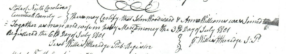
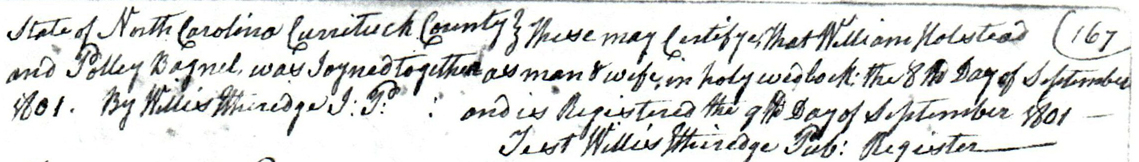