“The county was formed in 1750 from Bladen County. 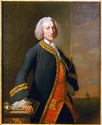 It was named for George Anson, Baron Anson, a British admiral, who circumnavigated the globe from 1740 to 1744, and later became First Lord of the Admiralty. He commanded the vessel which brought Princess Charlotte of Mecklenburg-Strelitz Germany, to her future husband King George III.”
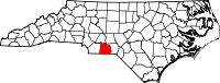
In 1750, when Anson County was formed from Bladen County, because North Carolina’s western boundary extended all the way across the English colonial territory, Anson County reached all the way to the Mississippi River. It has been cut in physical size five times since then. If you wish to see how the county evolved over the years, open this link: North Carolina County Formation.
“Like its parent county, Anson County was originally a vast territory with indefinite northern and western boundaries. Reductions in its extent began in 1753, when the northern part of it became Rowan County. In 1762 the western part of Anson County became Mecklenburg County. In 1779 the northern part of what remained of Anson County became Montgomery County, and the part east of the Pee Dee River became Richmond County. Finally, in 1842 the western part of Anson County was combined with the southeastern part of Mecklenburg County to become Union County.” [Wikipedia article]
The following counties were once part of Anson County:
Alexander, Alleghany, Ashe, Avery, Buncombe, Burke, Cabarrus, Caldwell, Catawba, Cherokee, Clay, Cleveland, Davidson, Davie, Forsyth, Gaston, Graham, Guilford, Haywood, Henderson, Iredell, Jackson, Lincoln, Macon, Madison, McDowell, Mecklenburg, Mitchell, Montgomery, Polk, Randolph, Richmond, Rockingham, Rowan, Rutherford, Scotland, Stanly, Stokes, Surry, Swain, Transylvania, Tryon, Union, Watauga, Wilkes, Yadkin, and Yancey.
From New and Complete Gazetteer of the United States, Thomas J. Baldwin and J. Thomas, M.D., Lippincott, Grambo & Co., Philadelphia, PA, 1854 (page 46):
ANSON – A county in the S. part of North Carolina, bordering on South Carolina, has an area of 650 square miles. Rocky River forms its entire boundary on the N., and the Yadkin or Pedee on the E. It is also drained by Brown’s and Lane’s creeks. The surface is undulating or hilly; the soil is mostly fertile. C otton is the staple product: Indian corn is also cultivated. In 1850 this county produced 389,828 bushels of corn; 35,796 of wheat; 95,113 of sweet potatoes, and 10,864 bales of cotton. The quantity of cotton was the greatest produced by any county in the state except Surry. It contained 26 churches and 2 newspaper establishments. There were 11 corn and flour mills, 9 saw mills, and 2 tanneries. Granite underlies a portion of the county. The forests contain the white oak and other hard timber. The Yadkin furnishes motive-power for several cotton factories in this county. It is intersected by a plank-road leading to Cheraw, South Carolina. Capital, Wadesborough. Formed in 1749, and named in honour of Admiral Anson, the famous navigator. Population, 13,489, of whom 6657 were free, and 6832 slaves.
Germans came to the present-day Anson County area, as did many settlers from the British Isles, Africa, and Moravia.
Also, see the history articles in the Archives for Anson, including the 1868 fire that burned the Courthouse:
Present-day Anson County contains the following communities:
Ansonville, Burnsville, Cairo, Cason Old Field, Cedar Hill, Deep Creek, Fountain Hill, Gravelton, Griffin’s Crossroads, Kikers, Lilesville, Little’s Quarters, Long Pine, Lowrys, McFarlan, Morven, Old Sneedsboro, Peachland, Pee Dee, Pinkston, Polkton, Shoates, Sugar Town, and Wadesboro.
Past communities that existed in Anson County at one time include:
Abecrumby, Beverly, Jones Creek, Lookout, Roper, and Tindallsville.
See the Maps page in the menu above for more detailed maps of Anson County.
And thank you for visiting Anson County NCGenWeb!